Earth by Allaby
Ref: Michael Allaby (2008). Earth. A Visual Guide. Metro Books.
___________________________________________________________________________
Summary
A visual guide to the latest thinking on all aspects of Earth science, from the formation of the planet to violent volcanic eruptions and the ever-changing patterns of life on Earth. Dive into the depths of the oceans and beyond, through rocks and minerals, right down to Earth’s core. Explore Earth’s different habitats, their plants and animals, and the role humans have played in their protection and demise. Then look to the heavens for a comprehensive guide to weather in all its manifestations.
___________________________________________________________________________
Earth’s History
Local Group: A group of galaxies that include the Milky Way, Andromeda, and the Triangulum Galaxy (‘M33’).
Asteroid Belt: A belt between Mars and Jupiter comprising millions of rocks that failed to coalesce into a larger planet due to tidal forces produced by the gravitational attraction of Jupiter.
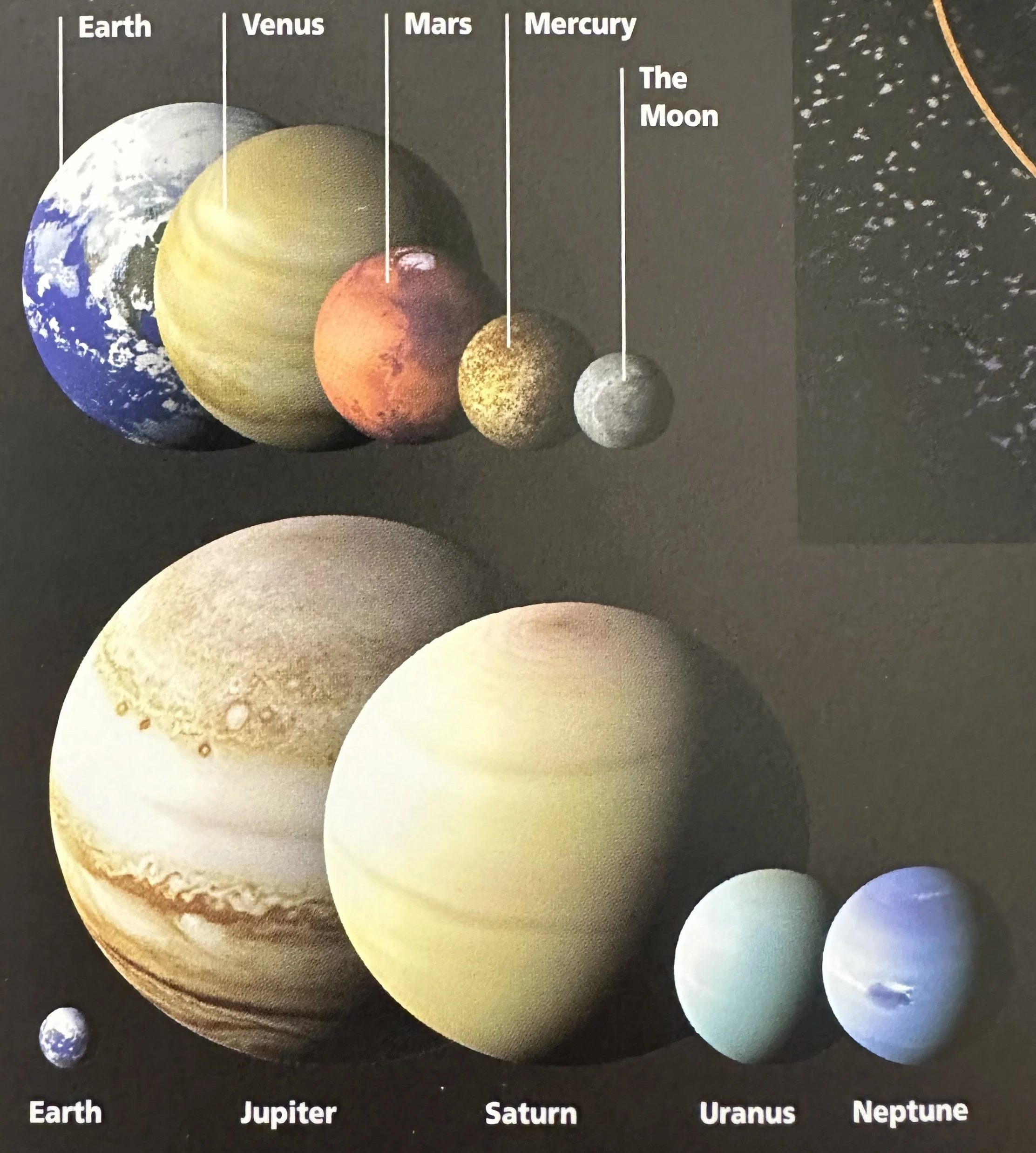
Distance from Sun (avg): Mercury: 58M km; Venus: 108M km; Earth: 150M km (Moon: Orbits Earth at 384,500 km); Mars: 228M km; Jupiter: 778M km; Saturn: 1.432B km; Uranus: 2.871B km; Neptune: 4.498B km; Pluto: 5.914B km.
Auroras: When the solar wind reaches Earth, its particles travel through the upper atmosphere along field lines in Earth's magnetic field, descending at the North and South poles. As they descend, the particles collide with O and N atoms, imparting energy to them. These atoms emit light as they return to their ground state, visible as curtains, bands or arches of light-the aurora borealis (N. lights) and aurora australis (S. lights). Auroras are most often seen in high latitudes, although sometimes they appear in latitudes as low as 40°.
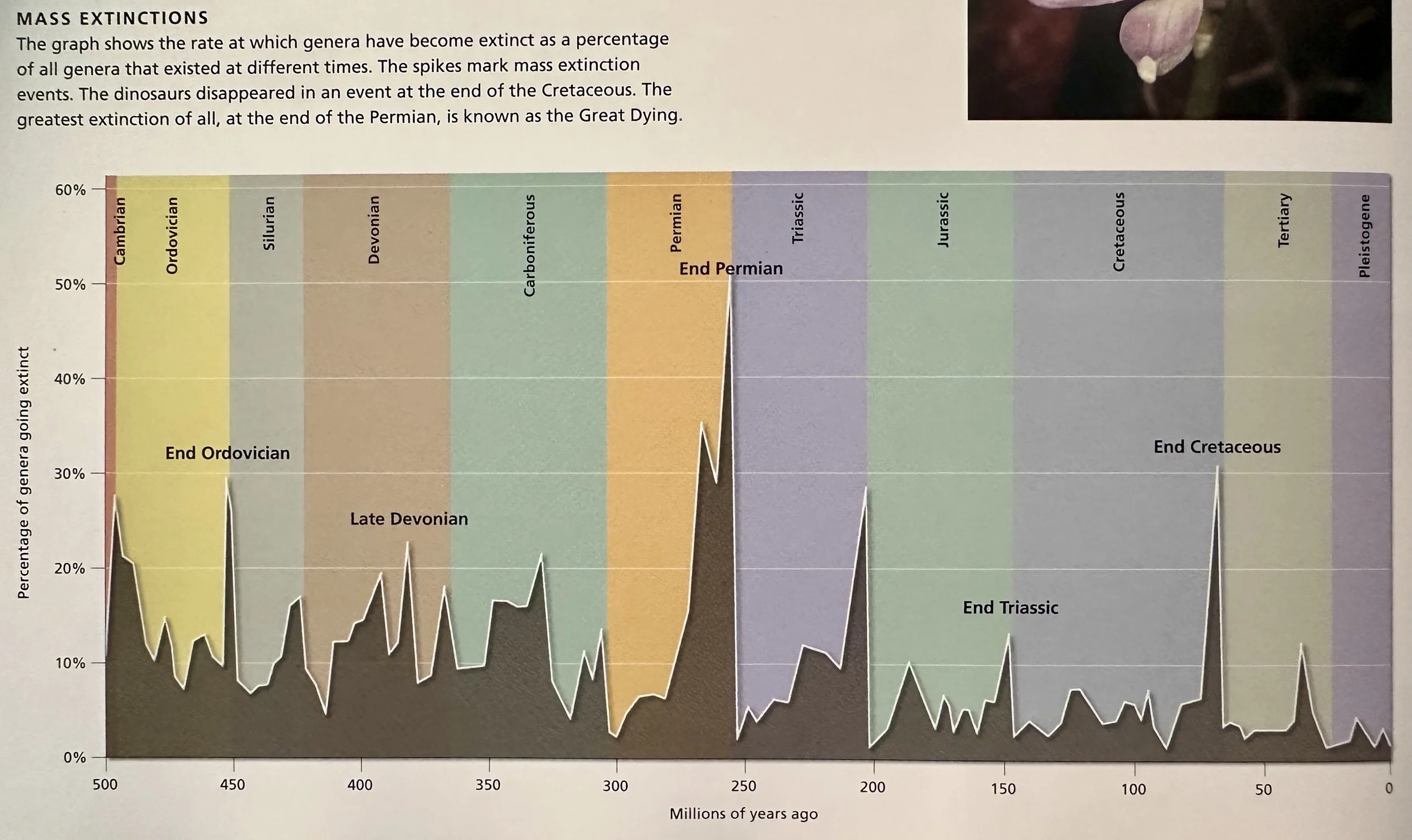
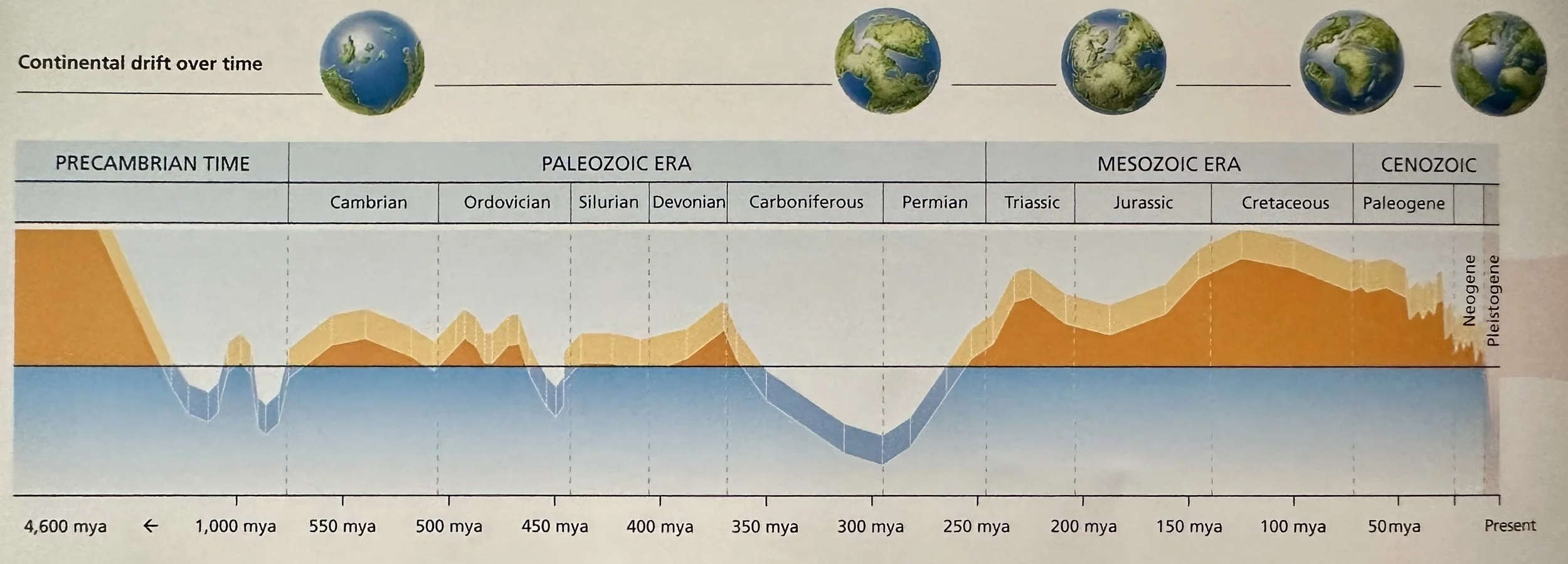
Paleozoic Era: Began ~542 Ma with the Cambrian period, marked by the Cambrian explosion, and ended 251 Ma with the Permian extinction (‘the Great Dying’). During the Paleozoic, there were two ice ages and the world's great landmasses merged to form the supercontinent of Pangaea. The Moon was closer to Earth than it is now, so the tides were stronger, and Earth rotated faster, which meant that the days were shorter. From simple beginnings, life continued to evolve during the Paleozoic. Many types of fish swam in the seas of the Devonian period. The first reptiles emerged, among them the mammal-like reptiles that were ancestors of the present-day mammals. Insects, including giant dragonflies, appeared and the first vascular plants established themselves on land.
Mesozoic (“Middle Life”) Era: The immediate ancestors of many modern plants and animals made their first appearance. The Mesozoic was a long era that lasted more than 180 My. It began 251 Ma, when life was recovering from the extinction of most invertebrate animals that took place at the end of the Permian period. It ended 65.5 Ma when an asteroid collided with Earth, causing yet another mass extinction. During the Mesozoic, life expanded on land, where dinosaurs were the dominant animals. Reptiles such as plesiosaurs lived in the oceans, and winged reptiles, the pterosaurs, took to the air. The first lizards and snakes appeared during this era. The pterosaurs were not the only flying animals: Archaeopteryx, the first bird, flew during the Jurassic period, in the middle of the Mesozoic. Before long, others followed. At the beginning of the Mesozoic all the continents were joined in the supercontinent Pangaea, but about 200 Ma Pangaea began to split in two- Laurasia in the north and Gondwana in the south. By the end of the Mesozoic most of the present continents had separated. In the early part of the era the climate was dry, with large seasonal extremes of temperature. During the Jurassic, sea levels rose, flooding large land areas. Temperatures became more moderate and rainfall increased.
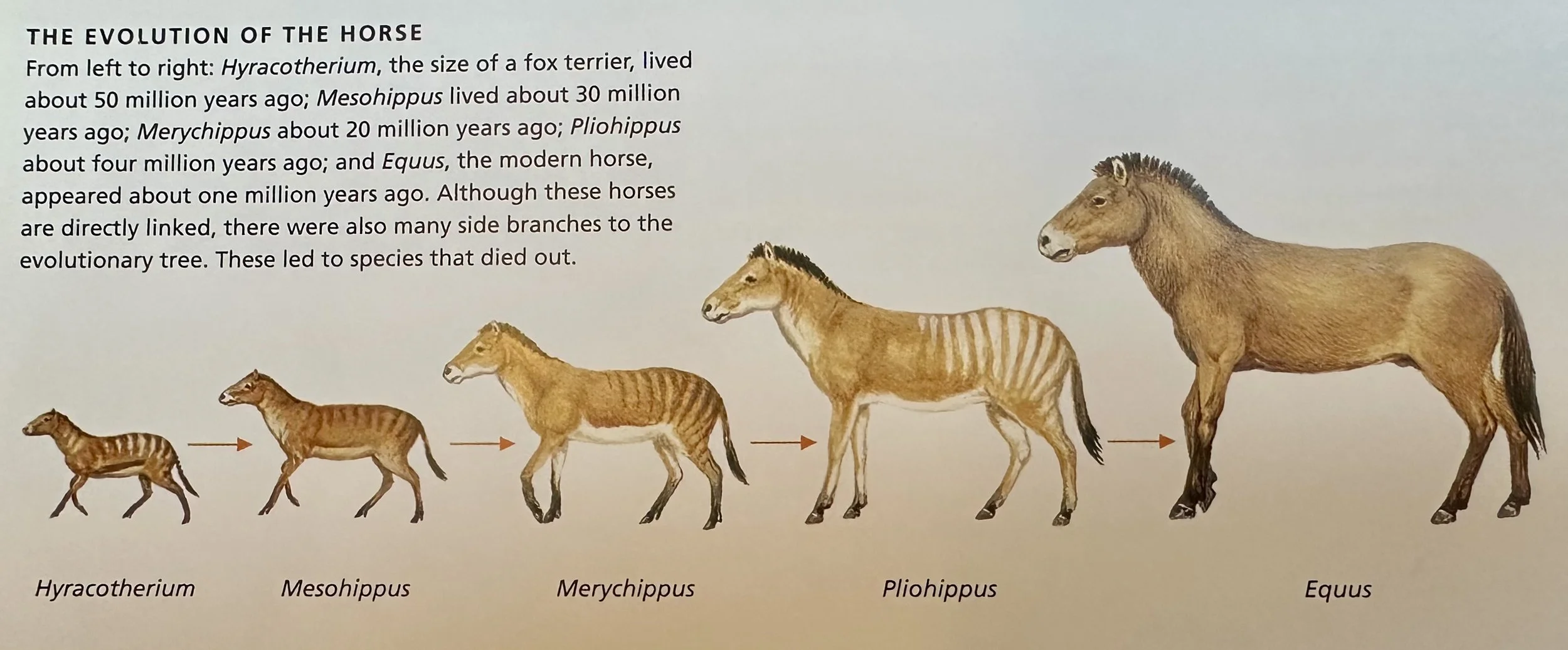
Cenozoic Era: Earth’s current geological era; began ~66.7 Ma following the K-T extinction and is characterized by the rise of mammals.
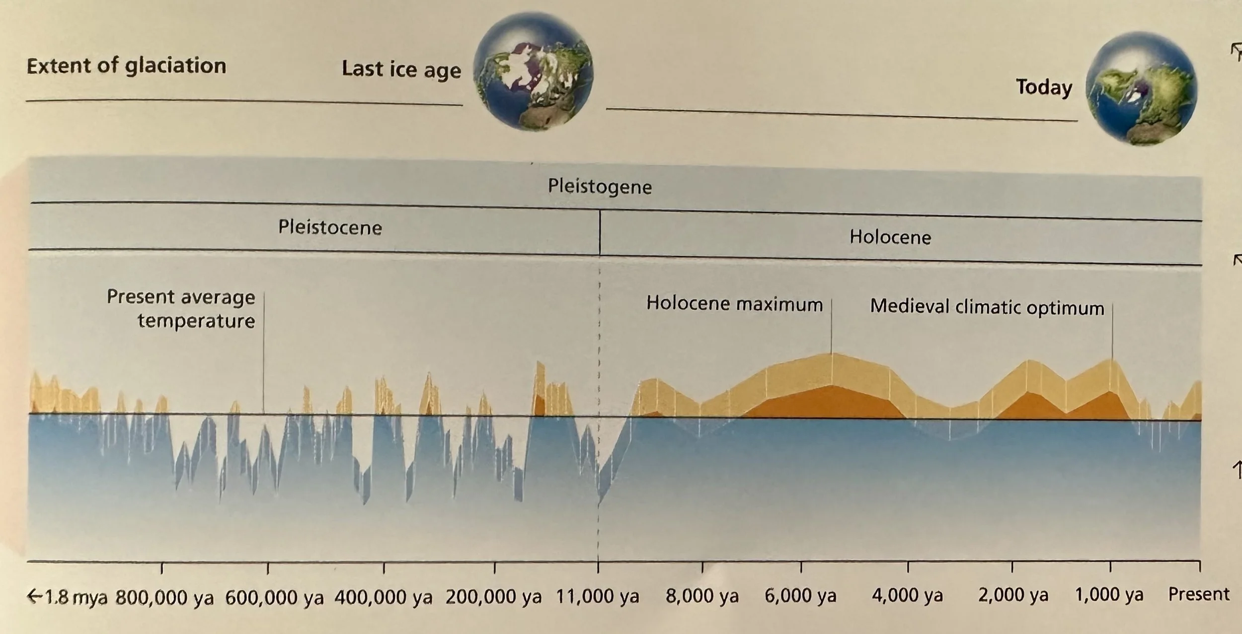
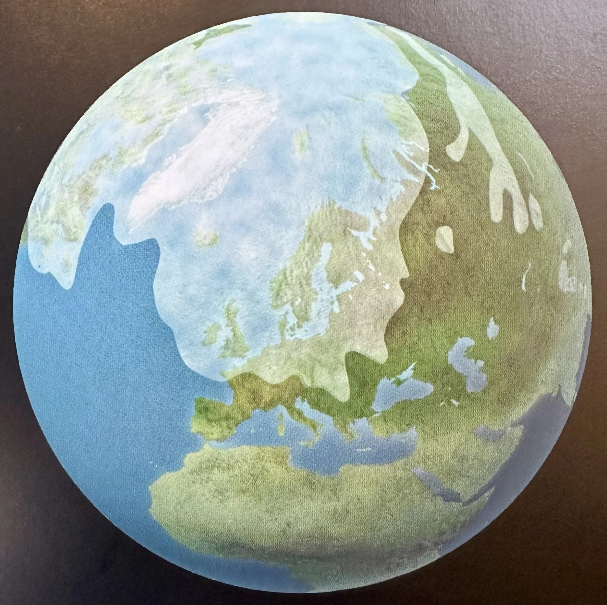
Pleistogene Period: Began ~1.81 Ma and continues to this day. It comprises two epochs- the Pleistocene, which ended 11 Ka and the Holocene, which followed it. The Pleistocene epoch is the age of ice. ~1 Ma temperatures began to fall and ice sheets began to advance in the first of the ice ages. Sea levels fell as more and more water changed to ice. When the ice age ended and the ice sheets retreated, sea levels rose once more. The Holocene began 11 Ka, when the ice sheets that had covered much of the northern hemisphere for the preceding 60 Ky began to retreat. Known as the Wisconsinian in North America, the Weichselian in northern Europe, the Würm in the Alps and the Devensian in Britain, the Holocene was the last of four major Pleistocene ice ages. Today we are living in an interglacial age known as the Flandrian. Scientists predict that one day the ice will return. The Pleistocene was not only an age of ice; it was also a period of giant mammals. Mammoths, mastodons, giant sloths, cave bears and saber-toothed cats roamed Earth at this time. All of these are now extinct. Neanderthal humans also lived during the Pleistocene, and for a time modern humans (H. sapiens) lived alongside Neanderthal humans (H. neanderthalensis). Modern humans began displacing Neanderthals ~45 Ka and Neanderthals became extinct ~30 Ka.
Holocene Epoch: With rising temperatures and the retreat of the ice, meltwater filled rivers that watered the newly exposed and barren land. Plant seeds from more temperate latitudes, blown by the wind or dropped by birds, germinated, and little by little the landscape turned green. In time, the forests returned—first the dark coniferous forests of northern climates, and later, where conditions were milder, the broad-leaved forests. With the forests came the animals, and following the animals came modern humans. Modern humans (Homo sapiens) appeared in Africa nearly 200 Ka, during the Pleistocene. As they expanded their range into Eurasia, the Neanderthals became fewer and by the late Pleistocene they were extinct. Homo floresiensis survived until at least 18 Ka, but throughout the 11,000 years of the present age, the Holocene, Homo sapiens has been the only species of human. During this time humans have occupied much of the world, replacing the natural vegetation with cultivated crops. The Holocene is too short to detect evolutionary trends, although most scientists fear that expanding human influence is driving many species toward extinction.
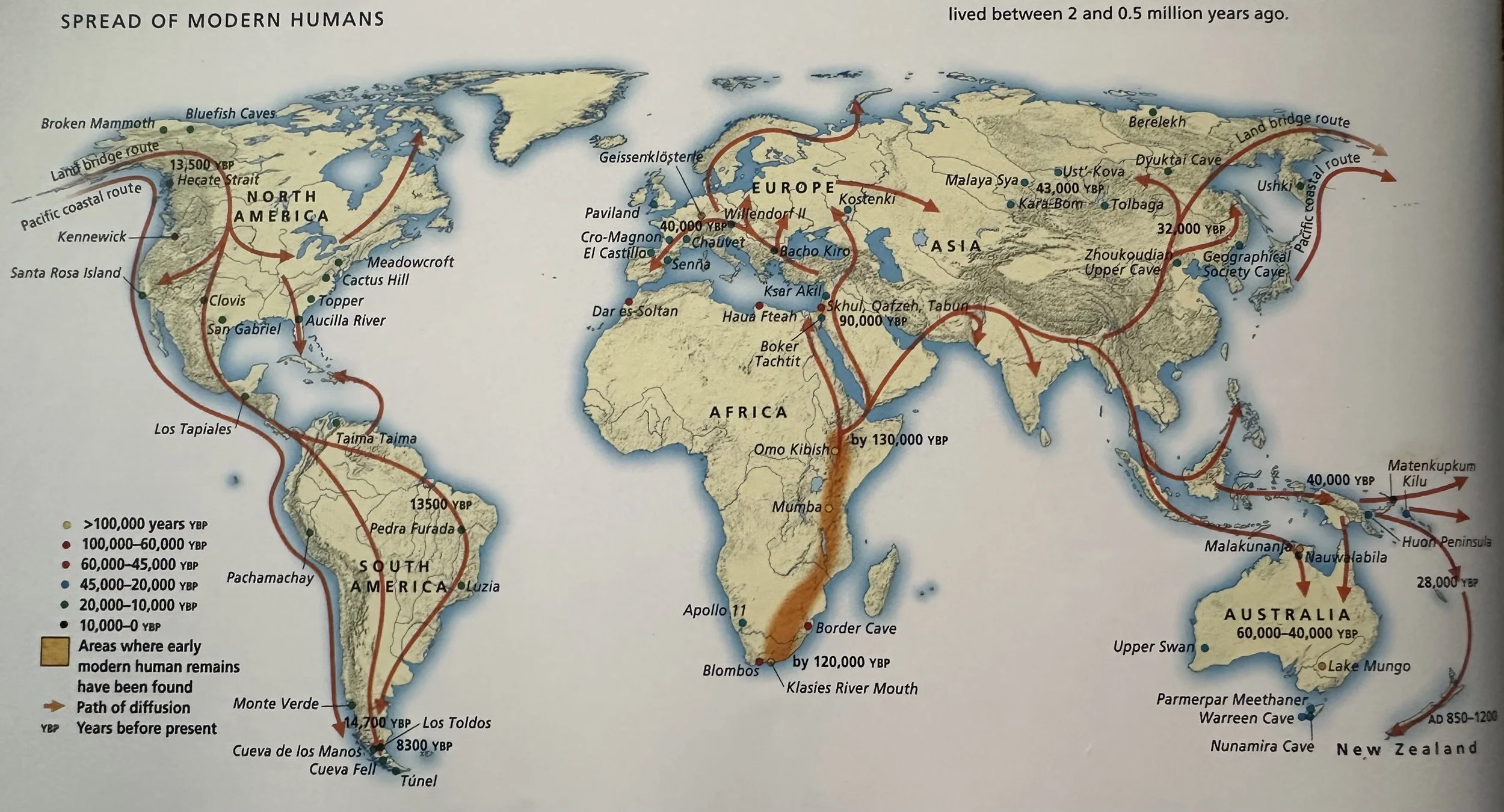
Emergence of Humans: Scientists classify humans in the subfamily Hominidae within the order Primates, which is the order comprising lorises, lemurs, tarsiers and all the monkeys and apes. The hominins are the African great apes-gorillas and chimpanzees-and humans, together with their immediate ancestors. ~5Ma, the evolutionary line that led to the emergence of humans separated from the line that produced our closest relative, the chimpanzee (Pan troglodytes). Many species of ancestral humans appeared and then became extinct in the course of those five million years. Out of all those species, only one survives. The first modern human (Homo sapiens) lived nearly 200 Ka in what is now Kenya, in eastern Africa. Wandering in search of food, perhaps following herds of game, humans gradually spread throughout eastern and southern Africa until, about 100,000 years ago, they moved farther afield. Some went eastward, reaching northern India about 80 Ka, China 60 Ka, Australia about 40 Ka and Siberia 14 Ka. Others traveled westward, arriving in central Europe 50 Ka.
___________________________________________________________________________
Inside Earth
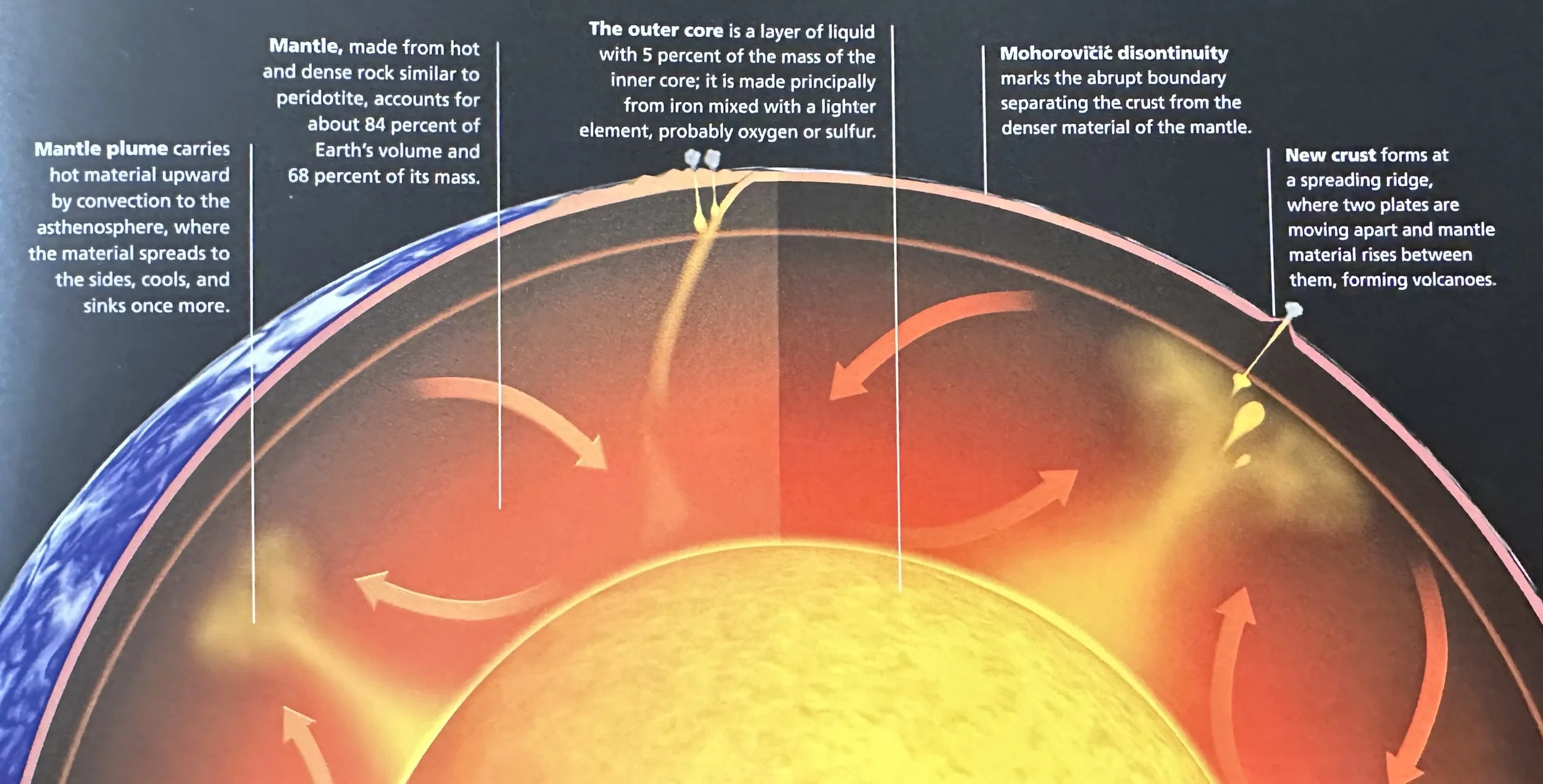
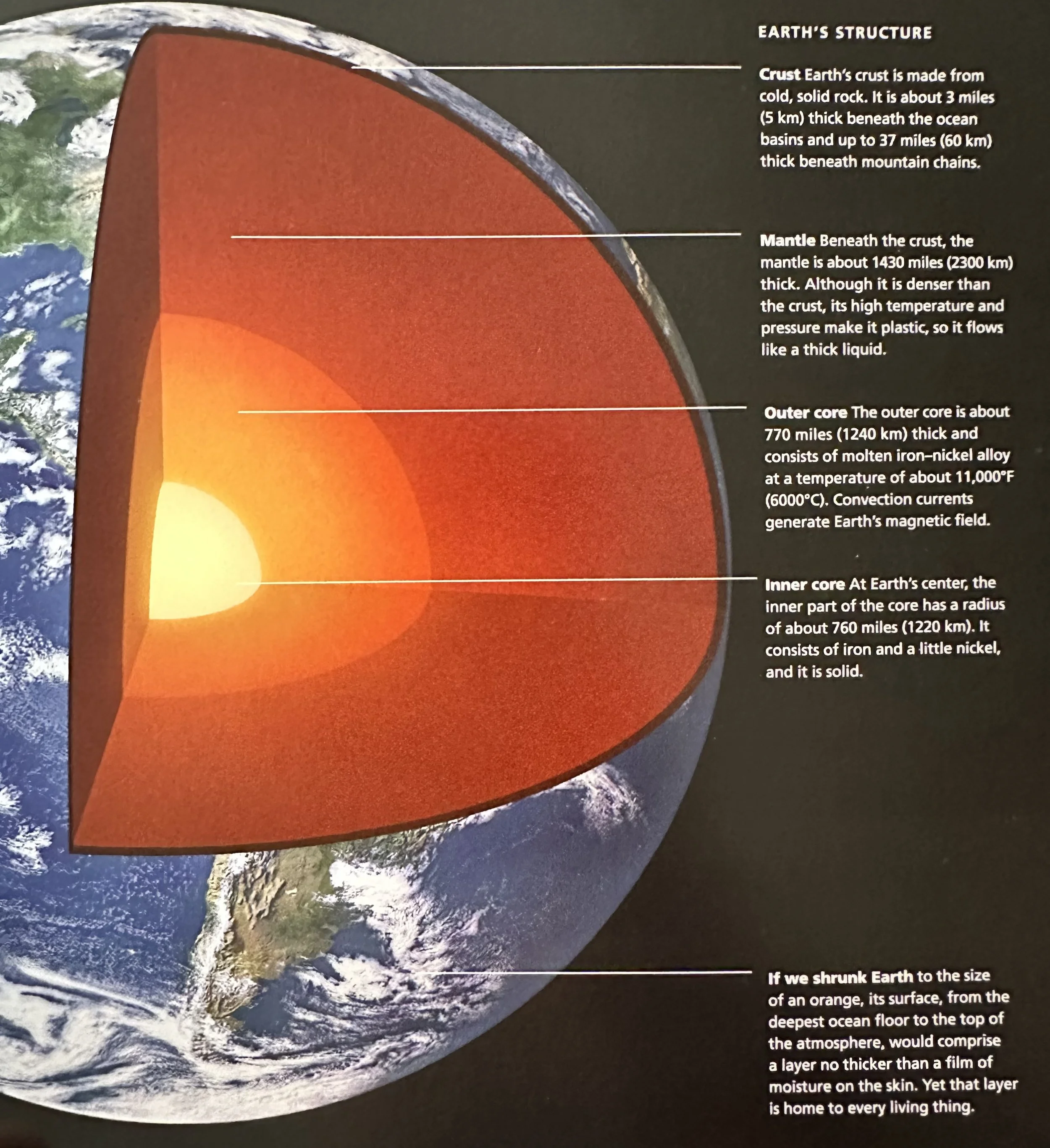
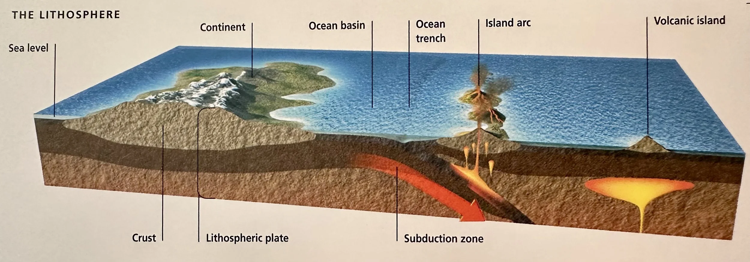
Crust: The outermost layer of the solid part of Earth; consists of large blocks of rock that rest on the mantle. Between the base of the crust and the top of the mantle there is a boundary marked by a change in the velocity of seismic waves, known as the Mohorovičić (‘Moho’) discontinuity. There are two types of crust: oceanic and continental. Both consist principally of silica and alumina, but differ in the minerals their rocks contain and therefore in the types of rock that constitute them. If the Earth was shrunk to the size of an orange, its surface, from the deepest ocean floor to the top of the atmosphere, would comprise a layer no thicker than a film of moisture on the skin of the orange.
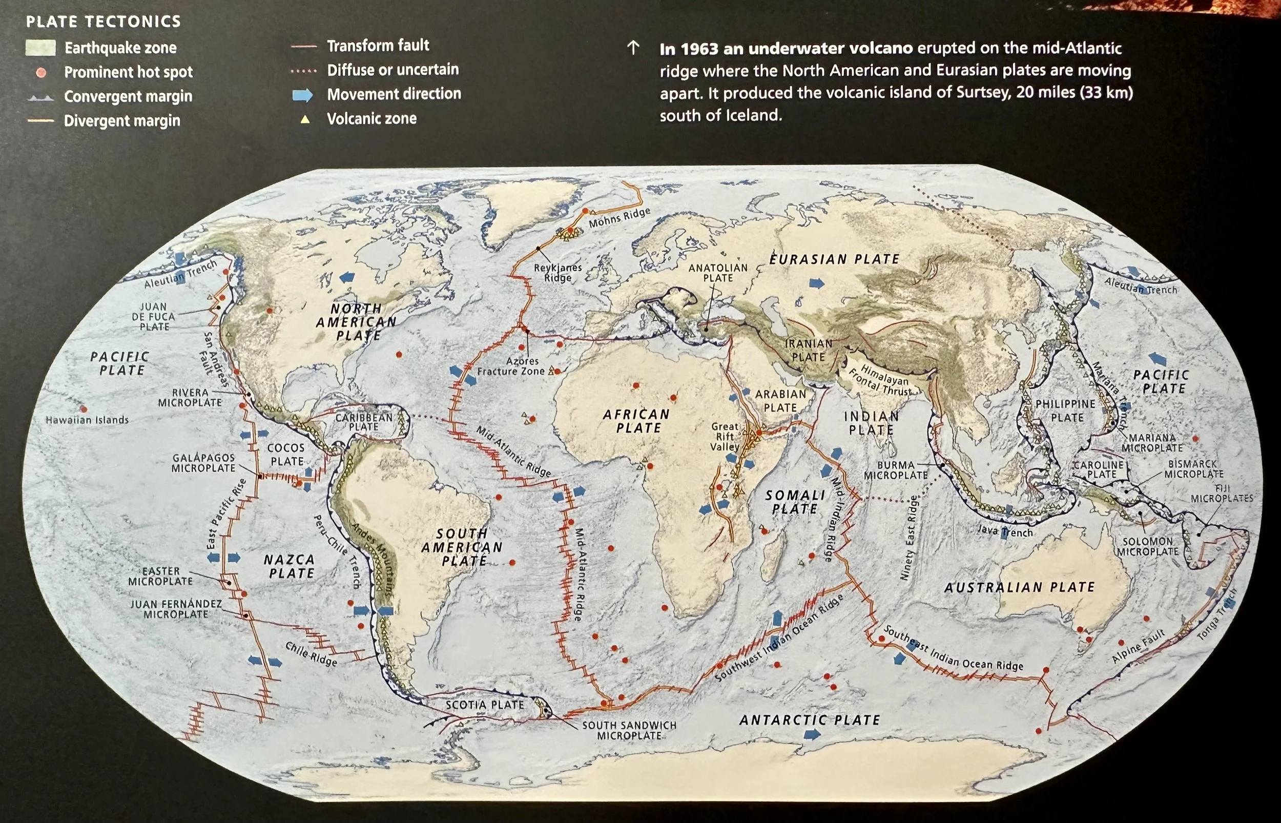
Oceanic Crust: Comprised of basalt rock overlain in most of its extent by sediment. It is between 5-15 km thick and covers ~59% of Earth's surface. Oceanic crust forms three layers of basaltic rock and a fourth, uppermost layer, when covered by sediment.
Continental Crust: Covers ~41% of Earth’s surface; but because it is much thicker, ~30-80 km, it accounts for 79% of the total volume of crustal rock. Granodiorite is the most abundant rock in continental crust.
Mantle: The layer of earth beneath the crust; ~2300 km thick. Although it is denser than the crust, its high temperature and pressure make it plastic, so it flows like a thick liquid.
Outer Core: The molten outer core with a radius of ~1240 km thick; consists of molten Fe-Ni alloy at a temperature of ~6000°C. Convection currents in the outer core generate Earth's magnetic field.
Inner Core: The solid inner the core at Earth’s center with a radius of ~1220 km; consists of Fe and a little Ni.
Asteroids: Rocky or Fe-rich bodies that orbit in the Asteroid Belt between Mars and Jupiter.
Ceres: The largest asteroid, with a diameter of 974 km (now classed as a dwarf planet).
The smallest asteroids are no bigger than small pebbles.
Comets: Formed from ices- including water ice, but also with many others-mixed with dust and soot. The American astronomer Edwin Hubble (1889-1953) described them as "dirty snowballs." They orbit in the outermost regions of the Solar System. From time to time, an asteroid's orbit may bring it close to Earth. If it enters Earth's atmosphere, friction will heat it and cause it to shine brightly. It is then termed an "atmospheric phenomenon," or meteor. Friction vaporizes most meteors, but a few fall to the surface. These are meteorites.
Meteorites: Meteor’s that fall to the Earth’s surface.
Trace Fossils (‘Ichnofossils’): Indirect evidence of the activity and life conditions of animals from the distant past. There are six main categories of trace fossils: 1) Domichnia: dwelling structures- burrows in which animals once lived; 2) Fodinichia: mining structures- burrows that animals dug while feeding on the sediment; 3) Pascichnia: grazing traces- traces made by animals that fed on the surface; 4) Cubichnia-resting traces- holes made by animals that buried themselves in the sediment; 5) Repichnia: locomotion traces- traces made by animals as they moved around; 6) Fugichnia-escape burrows- tunnels dug by animals that moved upward through sediment that had recently buried them. Larger vertebrate animals have also left trace fossils in the form of footprints or fossilized dung (‘coprolites’).
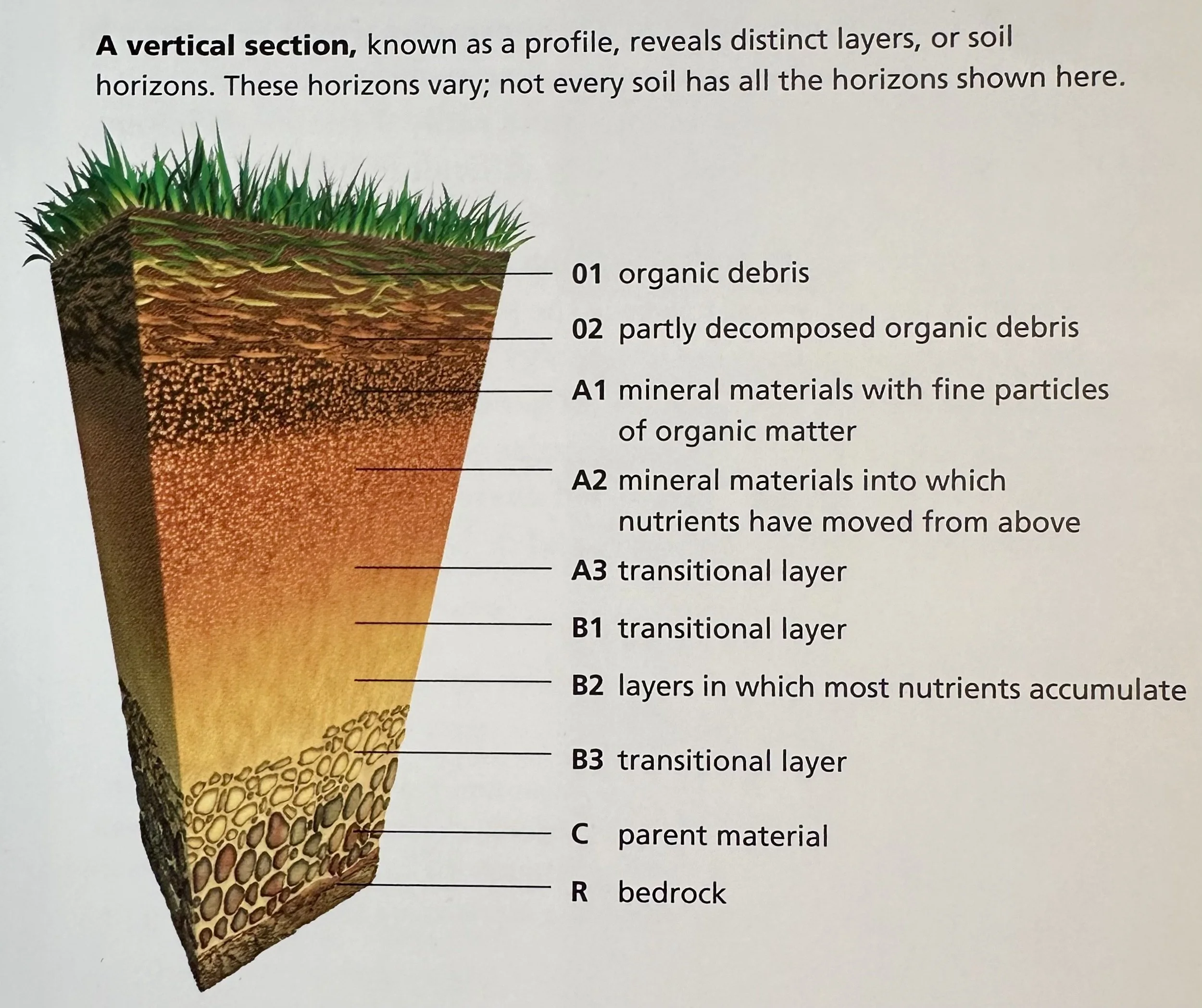
Soils: As soon as rocks are exposed to the effects of wind, rain, freezing and thawing, as well as to a range of chemical solutions that dissolve compounds within them, they begin to erode. Small fissures that appear fill up with mineral grains and rainwater. These fissures provide sites in which seeds or spores can germinate and where the resultant small plants can find secure anchorage and the nutrients they need. When these plants die, their tissues decompose and mix with the minerals. That is the beginning of soil formation. The scientific term for this process is pedogenesis. As years pass, the ever-growing accumulation of minerals and plant material creates conditions in which bigger plants can establish themselves. The soil gradually matures until it reaches a point of optimum fertility. After that it ages and eventually becomes infertile.
___________________________________________________________________________
Shaping the Surface
Slab Avalanche: The most dangerous type of avalanche in which snow, rocks, and uprooted trees rush downhill. Avalanches occur on slopes of between 30-40 degrees when the shear stress caused by the weight of the snow exceeds the shear strength.
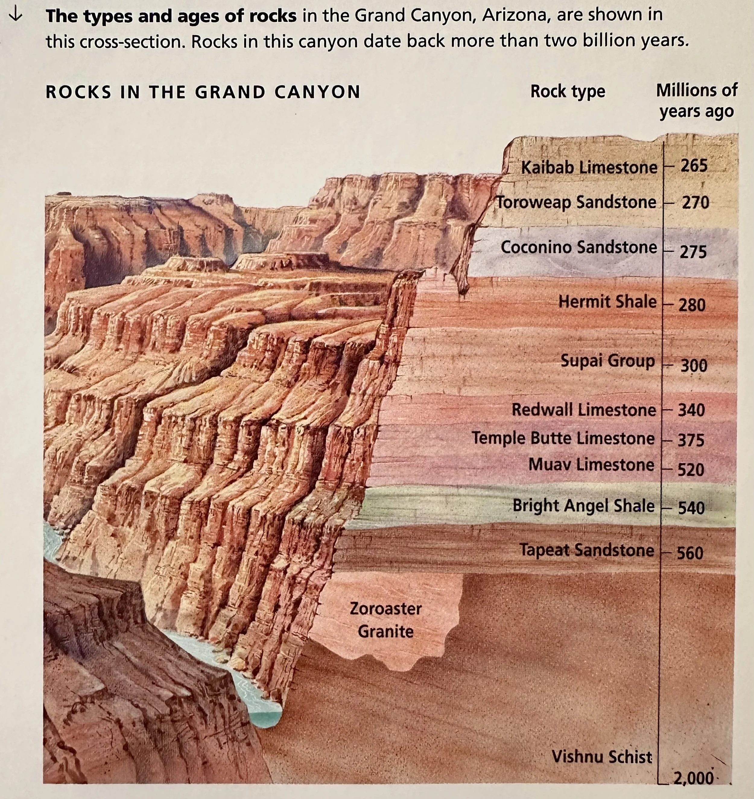
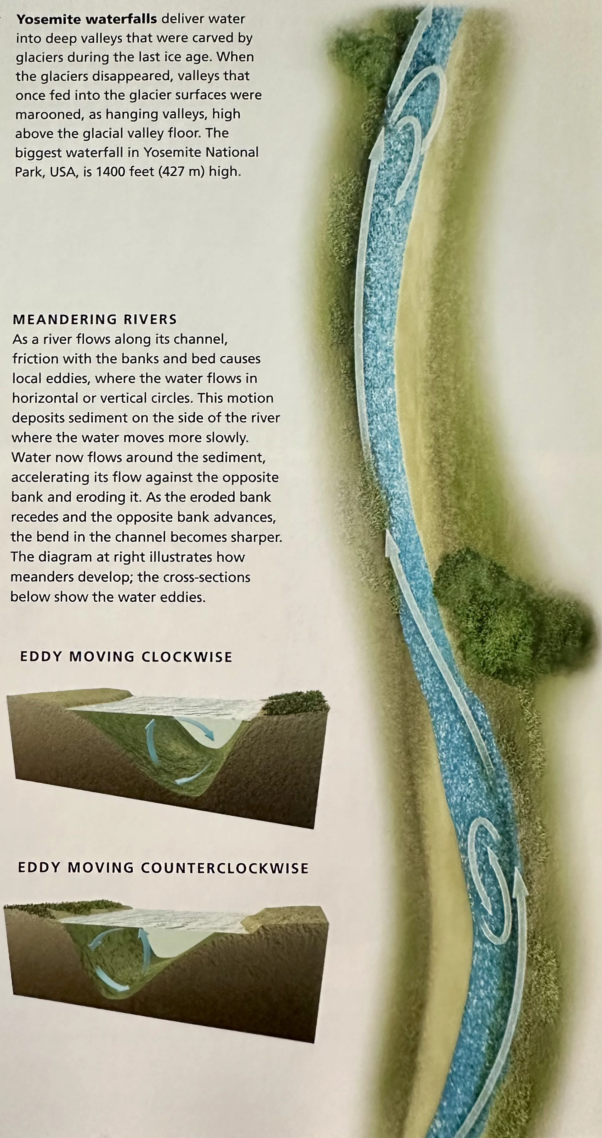
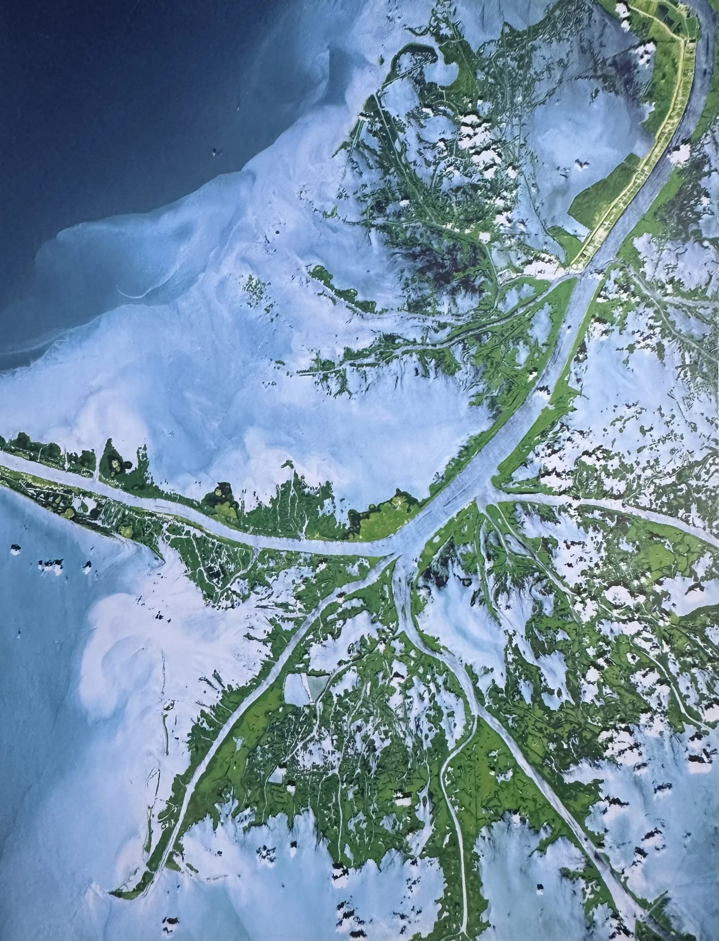
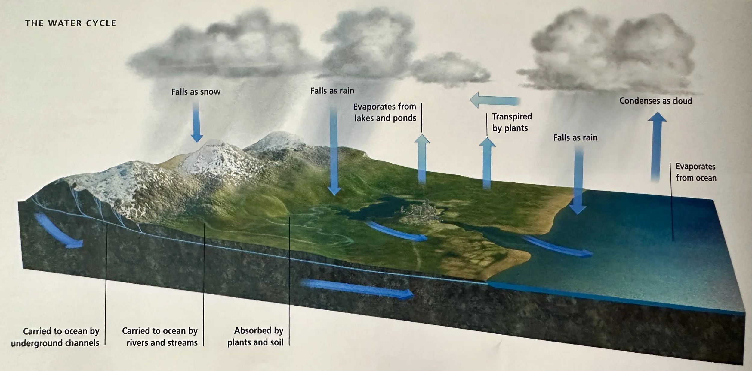
River Erosion: One cubic foot of water weighs ~60 lbs (1 m3 weighs ~1 t); water is heavy and when it moves across the land it can exert tremendous force. Rivers cut their channels through solid rock, in some places carving deep canyons. In order to carve channels, the rivers must remove the material that once filled them. Large rivers also acquire water from tributaries. The tributaries collect water that has flowed over and beneath the surrounding land, and that water, as well as the tributaries themselves, also excavates channels through which it flows. It is a slow but persistent process that continues for millions of years. Rivers scour mineral particles and grains from the land that they drain and transport all of these to their lowland flood plains, and eventually to the sea. A major river moves a staggering quantity of sediment. The Mississippi River, for example, delivers > 203M t into the sea each year and the Ganges transports ~1143M t. The sand and mud that cover the seafloor came originally from the land. The water that rivers carry originally came from the sea; its return closes the hydrological, or water, cycle. Every year approximately 321,000 km3 of water evaporate from the oceans and 62,500 km3 from land; about 87,500 km3 fall over land. The balance, 25,000 km3, is the amount of water rivers return to the sea annually.
Types of Faults
Normal Fault: A dip-slip fault in which the rock on the upper side of the fault plane (the hanging wall) moves downward over the underlying rock (the footwall).
Reverse Fault: A dip-slip fault in which the hanging wall rocks move upward over the footwall.
Thrust Fault: A dip-slip, low angle fault in which the hanging wall overhangs the footwall.
Strike-Slip (Transcurrent, Transform): Rocks move horizontally. The fault is called dextral if it moves a marker to the right, and sinistral if the marker moves to the left.
Ice Cap (Sheet): Forms from the continual accumulation of snow that compresses underlying snow into ice. The weight of snow and ice forces ice outward at the base, so an ice sheet lies on top of moving ice.
Ice Cap: Covers an area < 50K km2.
Ice Sheet: Covers an area > 50K km2.
Ice Shelf: The part of the Ice cap or sheet that extends over the sea.
Iceberg: Part of an ice shelf that breaks away (‘calves’) into the sea.
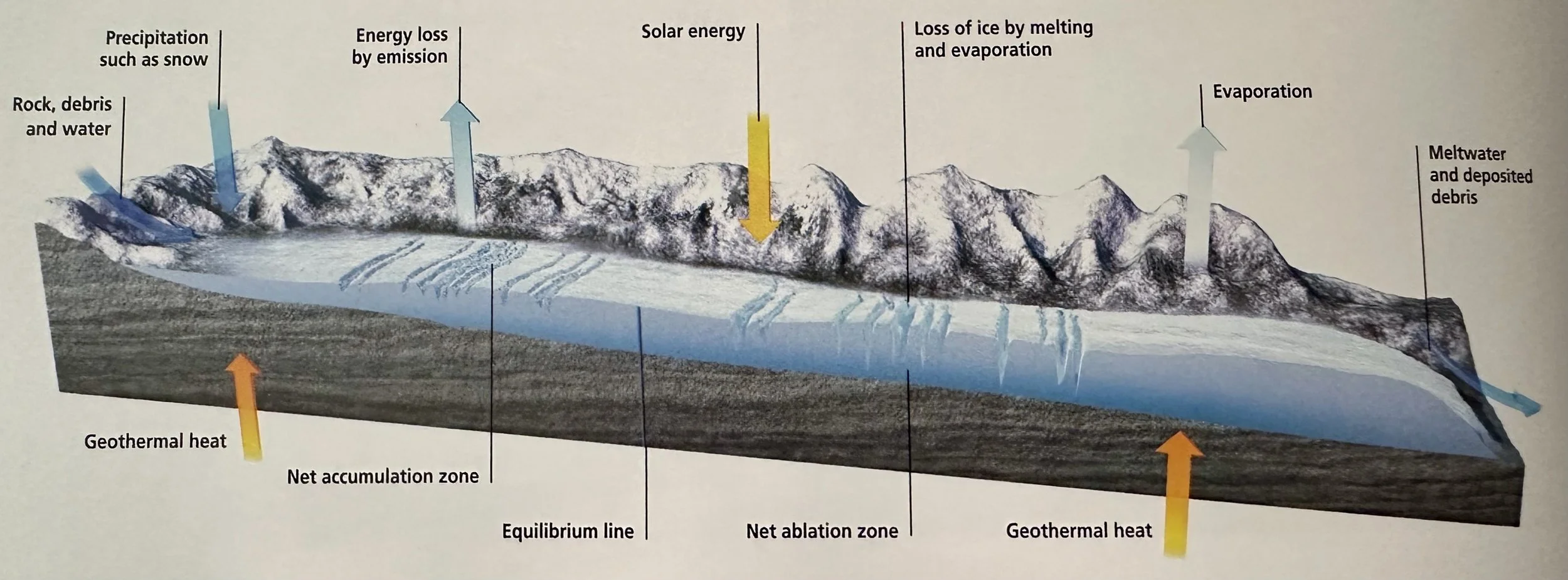
Glacier: A mass of moving ice. The base of glaciers are warmed by geothermal heat, causing them to flow by gravity. At the upper levels snow continues to accumulate in the net accumulation zone, but water is also lost by evaporation, sublimation and wind (deflation). In the net ablation zone below the equilibrium line the glacier loses mass faster than it receives it.
Fjord: The seaward end of a glacial valley. The glacier has melted and seawater has flooded the deep valley carved by the glacier. The existence of fjords indicates that the climate was once colder than it is now.
___________________________________________________________________________
Seas & Oceans
Blue Planet: Oceans and seas cover 70% of Earth's surface. Their average depth is 3730 m and they hold 1370 km3 of water. When seawater evaporates, some of the vapor condenses to form clouds over land. Water from these clouds falls as precipitation, and rivers carry it back to the sea. As water flows across the land and below the surface as groundwater, substances from rocks and soil dissolve into it. Water that returns to the ocean is a solution of many substances and seawater contains dissolved substances that have been accumulating for billions of years. When water evaporates, however, only water molecules escape into the air; substances dissolved in the water are left behind. That is why the sea is salty. NaCl- common salt- is what gives the sea its taste. Seawater also contains, in descending order of quantity, sulfate, Mg, Ca, K, bicarbonate, bromide, borate, St and F. These substances make up 99.9% of the dissolved material.
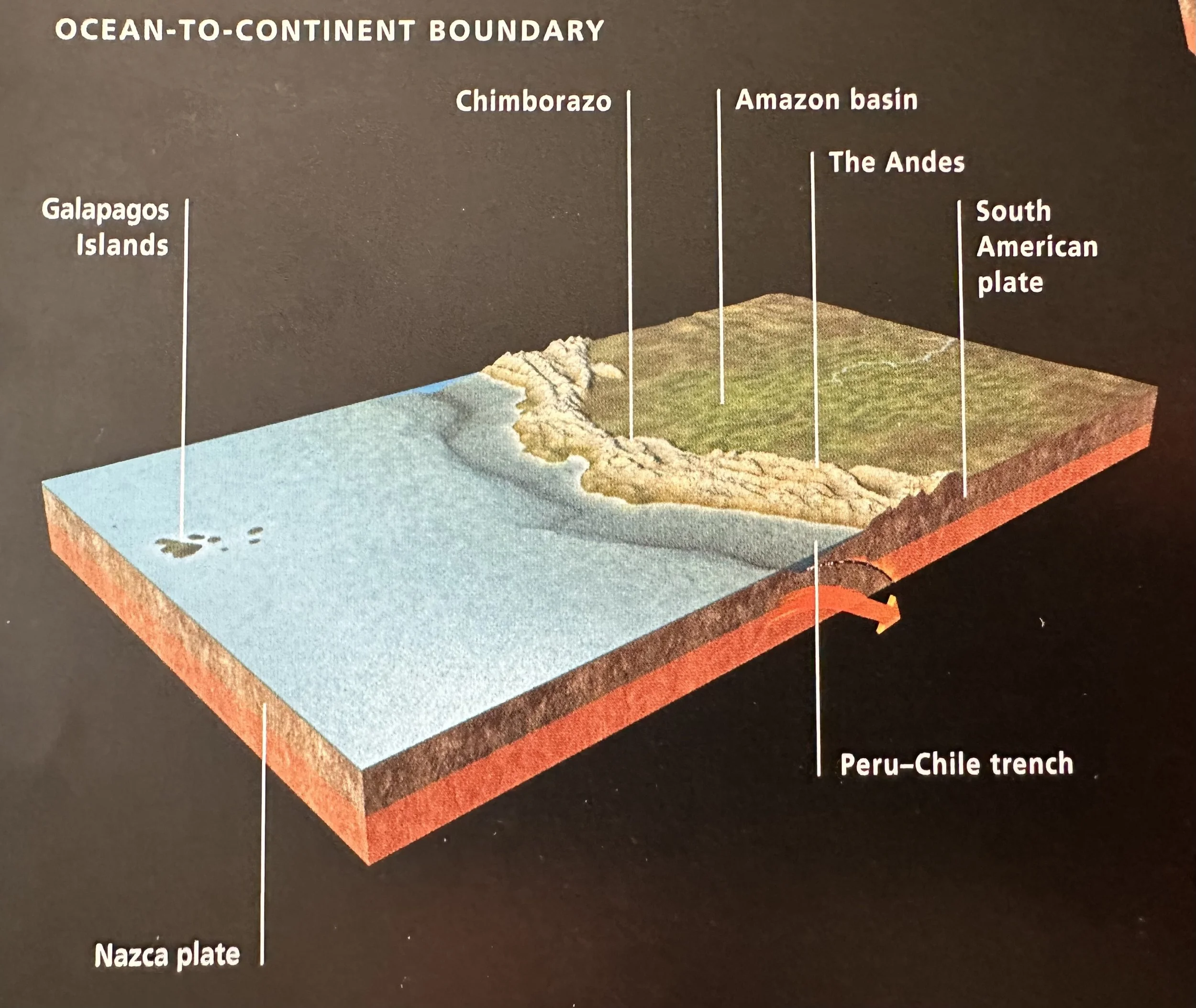
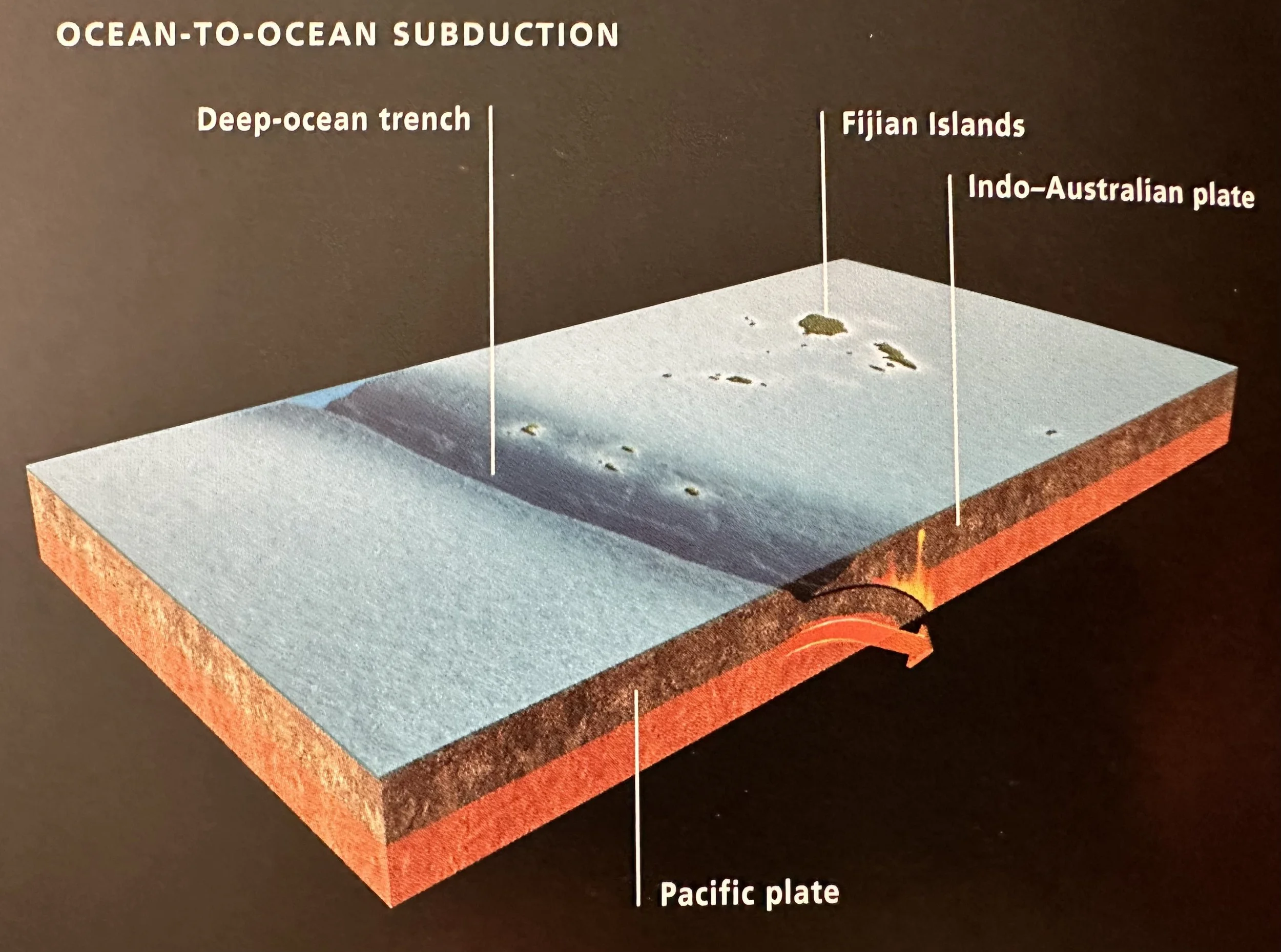
Ocean Floor: Close to the shore, the seabed slopes gently. This is the continental shelf and it ends on average at 72 km from the shore, where the water is ~152 m deep. From that point the seabed slopes more steeply down the continental slope. Sediment slides slowly down the continental shelf, in many places along deep canyons that end in fan-shaped deposits. It then falls more rapidly down the continental slope onto the continental rise, which extends for hundreds of km. Beyond the continental rise lies the bathyal zone, where the ocean depth is from 200-2000 m. This part of the ocean floor includes deep trenches associated with subduction zones, and submarine canyons where erosion triggers submarine landslides. The deepest part of the ocean, below 2000 m, is called the abyssal zone. This accounts for 75% of the total ocean floor. It is cold, totally dark and animals that live there are black or gray. Not a glimmer of sunlight penetrates. Water currents move at a few inches per second. There are hills in the abyss, and volcanic mountain ranges at mid-ocean ridges where crustal plates are moving apart and the sea floor is spreading.
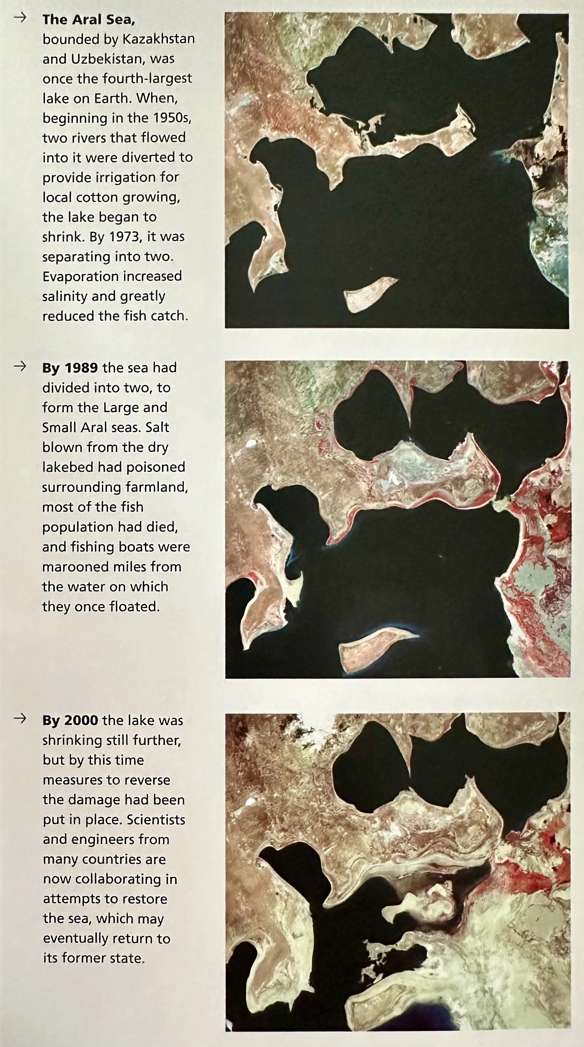
Salt Flats: Salt deposits that form on land as a result of evaporation after an area of sea becomes cut off or water ceases to flow into a salt lake.
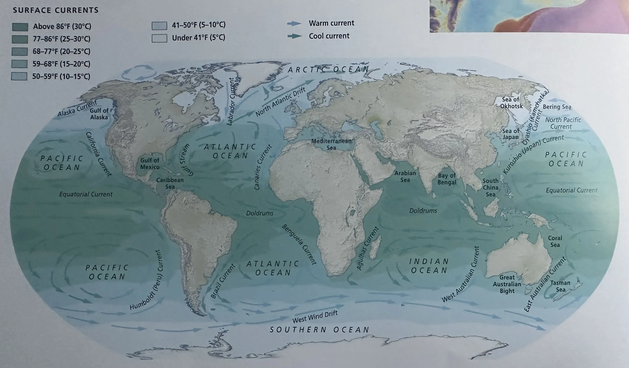
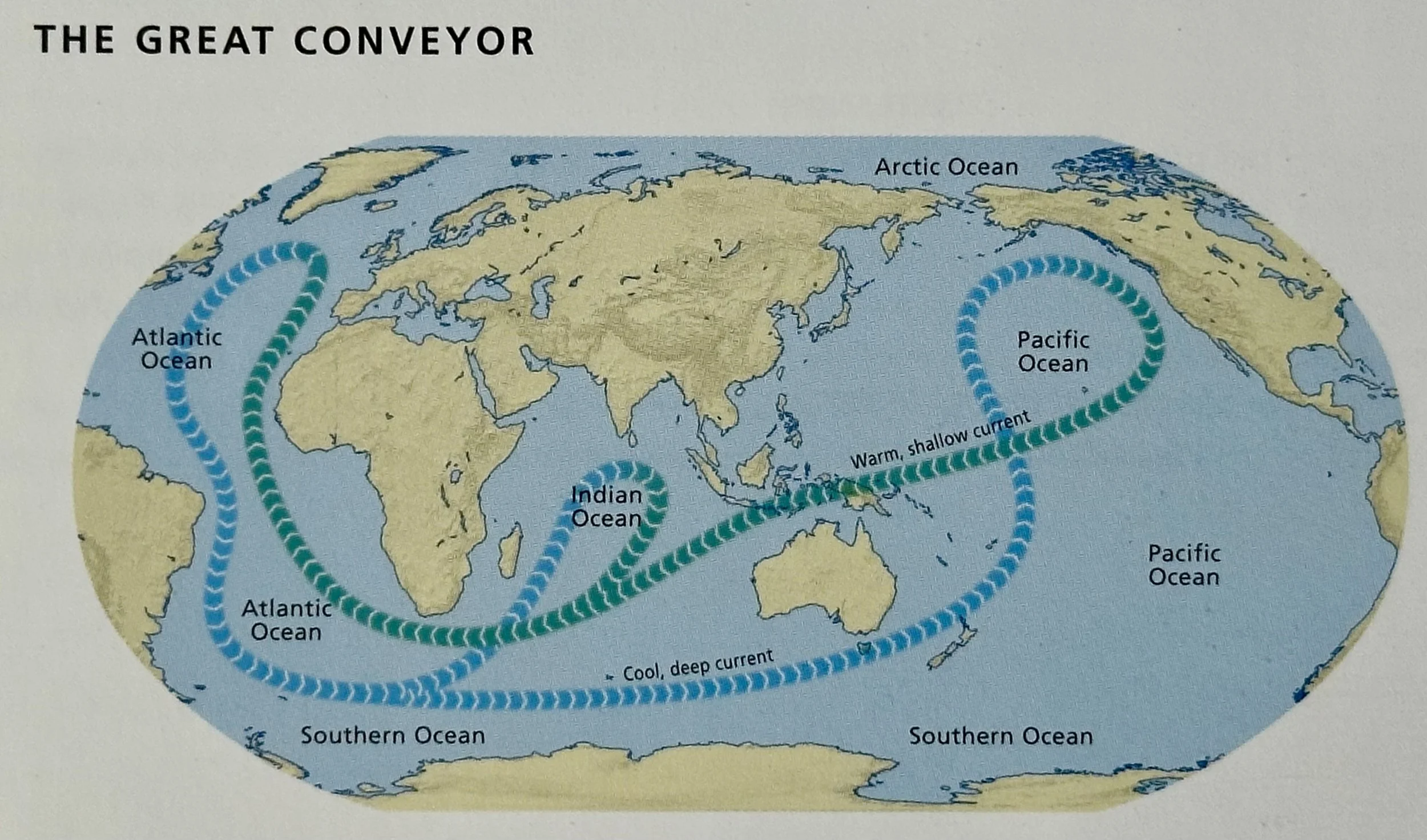
Currents: The flow of water within an ocean or sea.
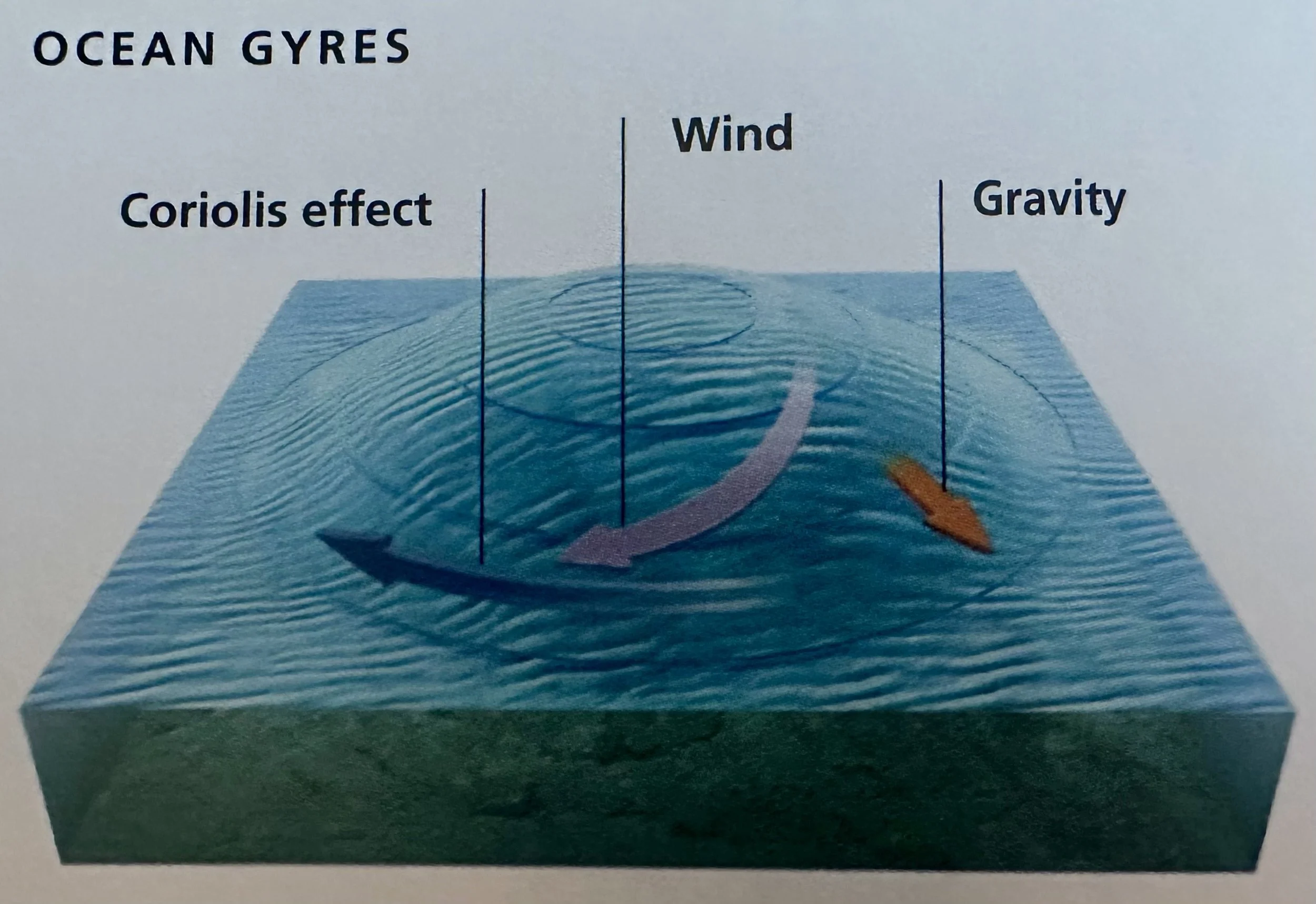
Gyre: Circular flow of currents due to the Coriolis effect, which deflects moving air or water to the right in the N. hemisphere and the left in the S. hemisphere; caused by the Earth’s rotation and its strength increases with distance from the equator. As the water moves farther from the equator it is deflected even more; at the same time it moves from the easterly tropical winds to the midlatitude westerlies, then back again. Eventually it turns in a circle.
Boundary Currents: The flow of a current parallel to continental coast. E. boundary currents carry cold water and W. boundary currents carry warm water. Boundary currents chill or warm air that passes across them.
Tsunami (‘harbor wave’- Japanese): Triggered by a displacement of rocks or sediment on the ocean floor. It may be an earthquake that suddenly raises or lowers the rocks on either side of a fault, or a submarine landslide that releases millions of tons of sediment. The displacement produces a shock wave that propagates outward throughout the entire depth of water. The wavelength is more than 160 km; the period can be minutes, or even hours; and the wave height is <90 cm. The wave travels at between 640-800 km/h. When it reaches shallow water near a coast, the wave slows, but as water continues to arrive from offshore its height increases. The tsunami moves ashore quickly, more like a rising tide rather than a breaker.
___________________________________________________________________________
Land
Lua
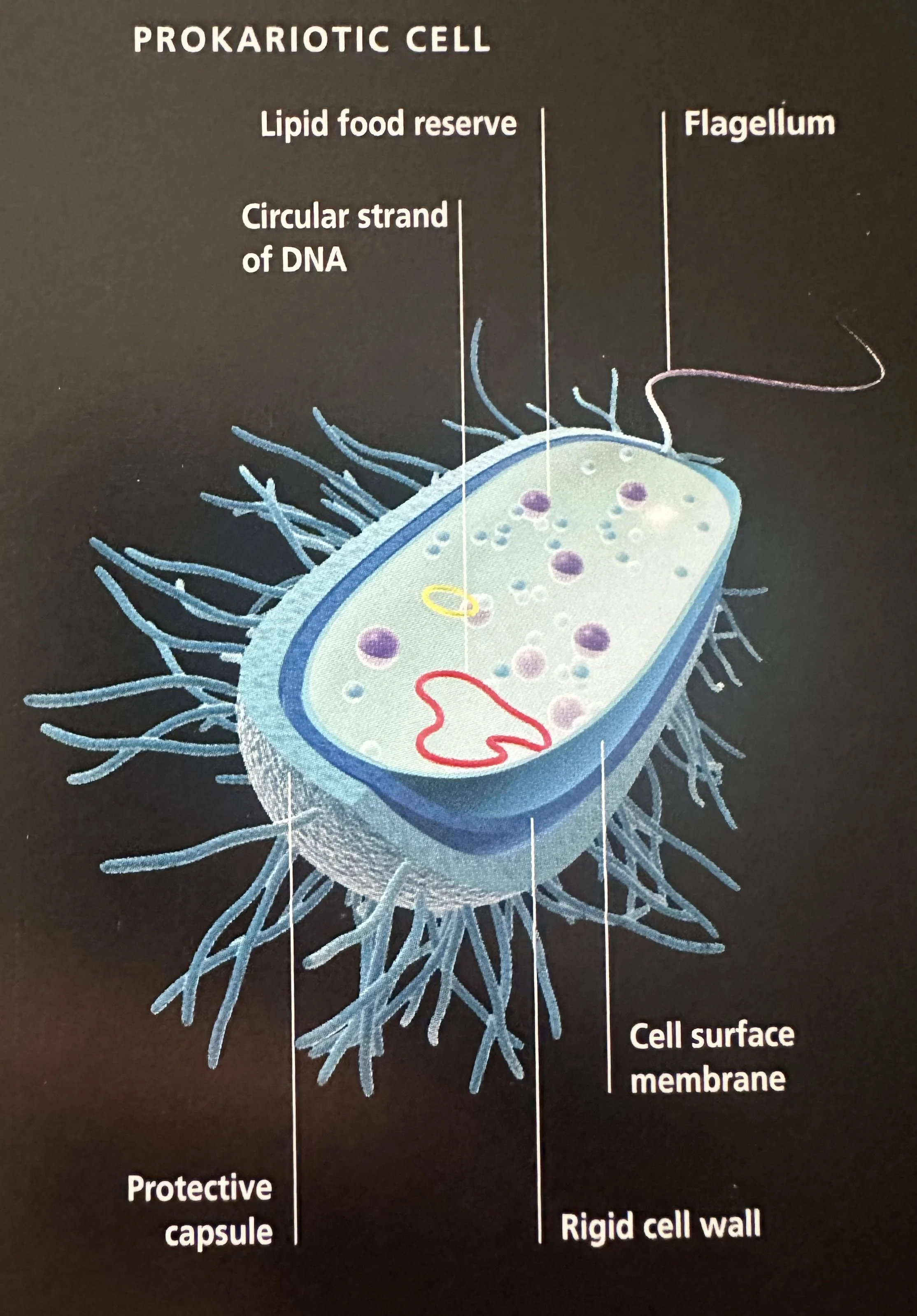
Bacteria: Aquifex, Thermotoga, Bacteroids Cytophaga, Planctomyces, Cyanobacteria, Proteobacteria, Spirochetes, Gram positives, Green filamentous bacteria.
Archaea:
Pyrodicticum
Thermoproteus
T. celer, Methanococus, Methanobacterium, Methadoarcina, Halophiles.
Eukaryota: Diplomonads, Microsporidia, Trichomonads, Flagellates, Entamoebae, Slime molds, Cliliates, Fungi, Plantae, Animalia.
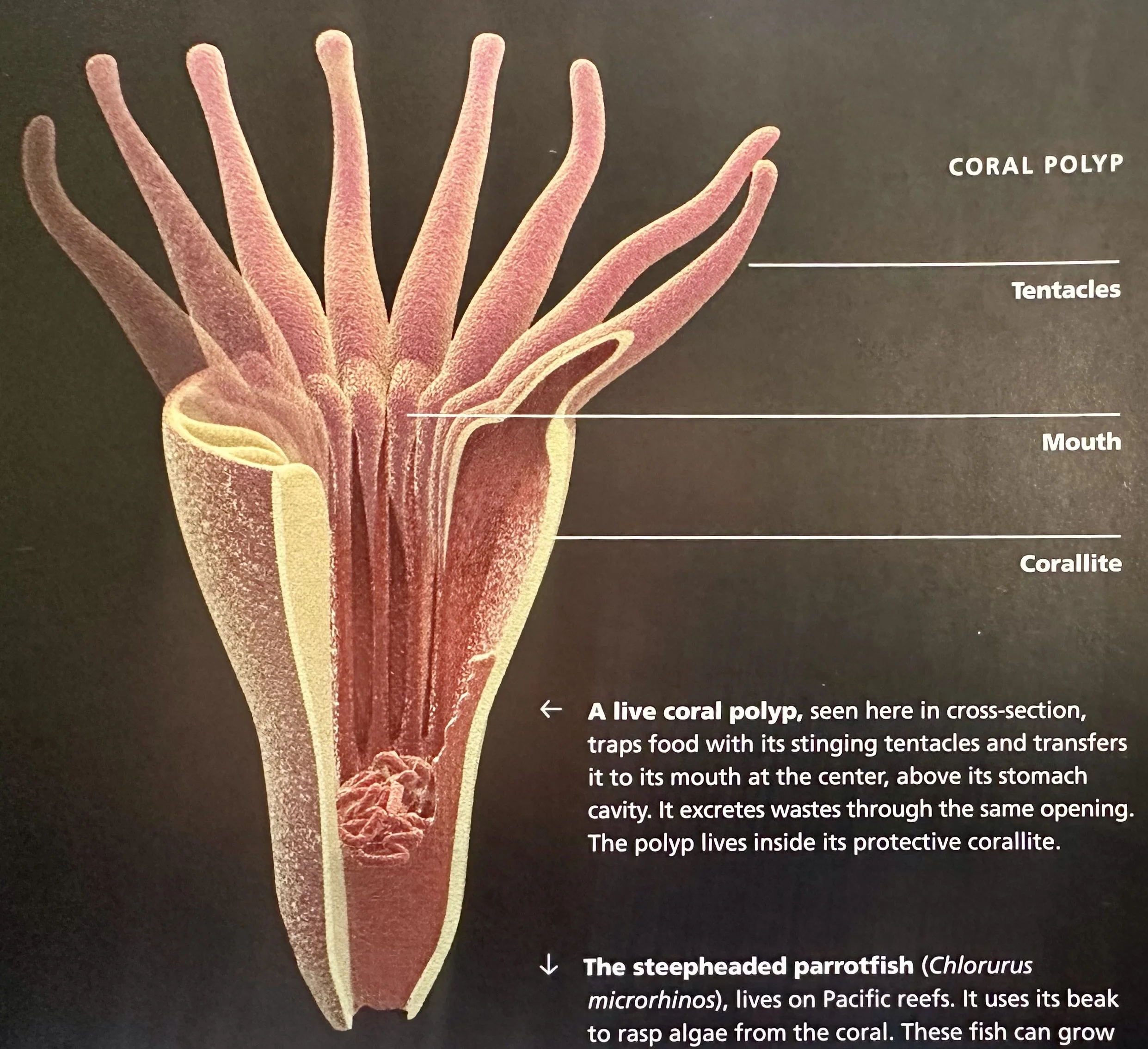
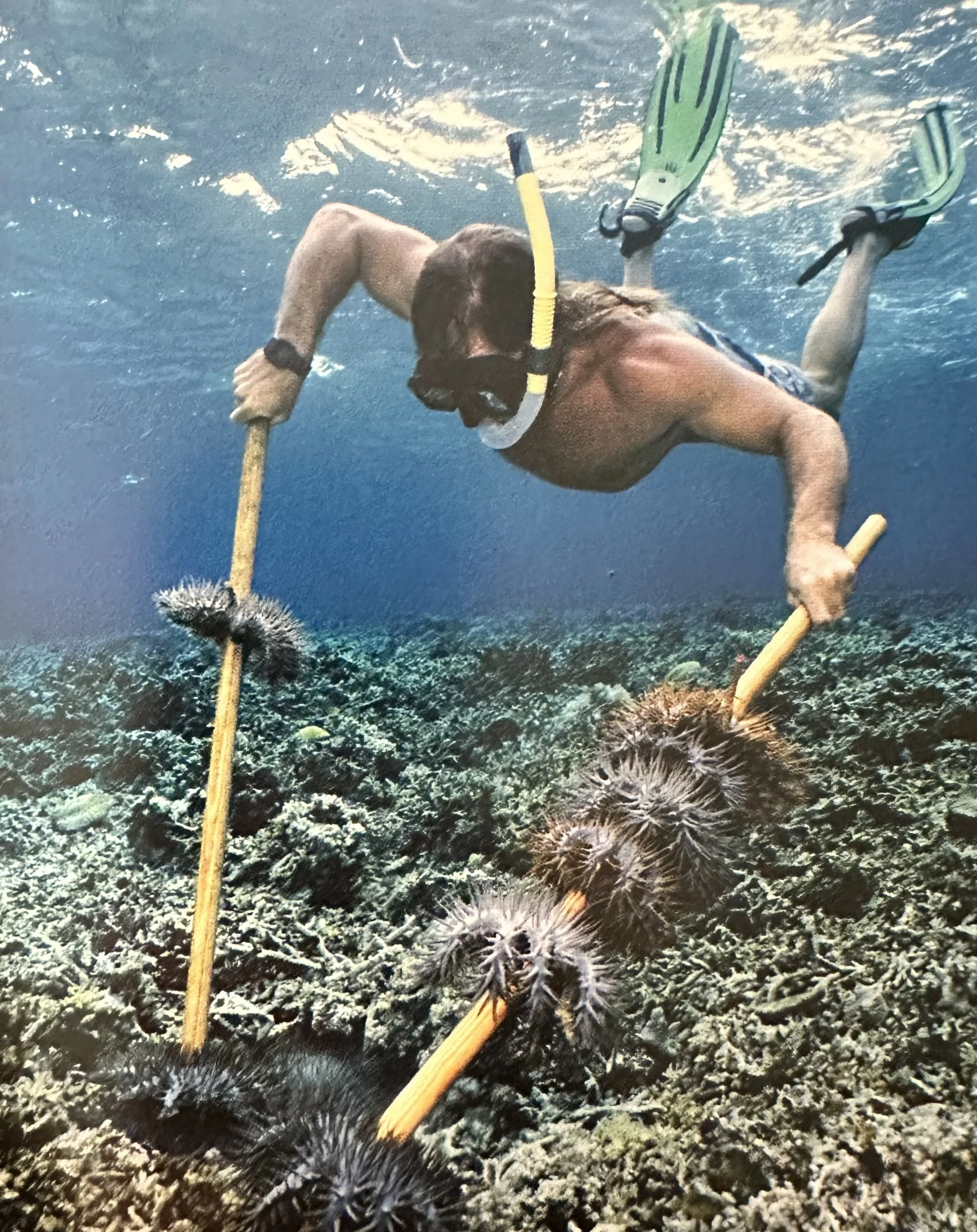
Coral Reefs: A corallite is the external CaCO3 covering that is secreted by polyps- cylindrical-shaped animals between 1-3 mm wide. A juvenile polyp resembles a jellyfish and drifts in the ocean. When it is ready to mature it anchors itself to a solid surface and at the other end it grows tentacles with which it gathers food items that float past. The polyp lives inside its hard skeleton, known as corallite, in close association with particular algae and dinoflagellates- single-celled protozoa- called zooxanthellae, with which it exchanges nutrients. Madreporaria, or stony corals, live in vast colonies where the corallites merge and grow into coral reefs. Reefs occur in all tropical and subtropical oceans. They grow best in clear, shallow water at a temperature between 23-25°C. On Earth, the total reef area is ~175M sqkm. Coral reefs are highly vulnerable to pollution, especially from sediment that clouds the water and interferes with photosynthesis by the corals' algae. They are also threatened by global warming.
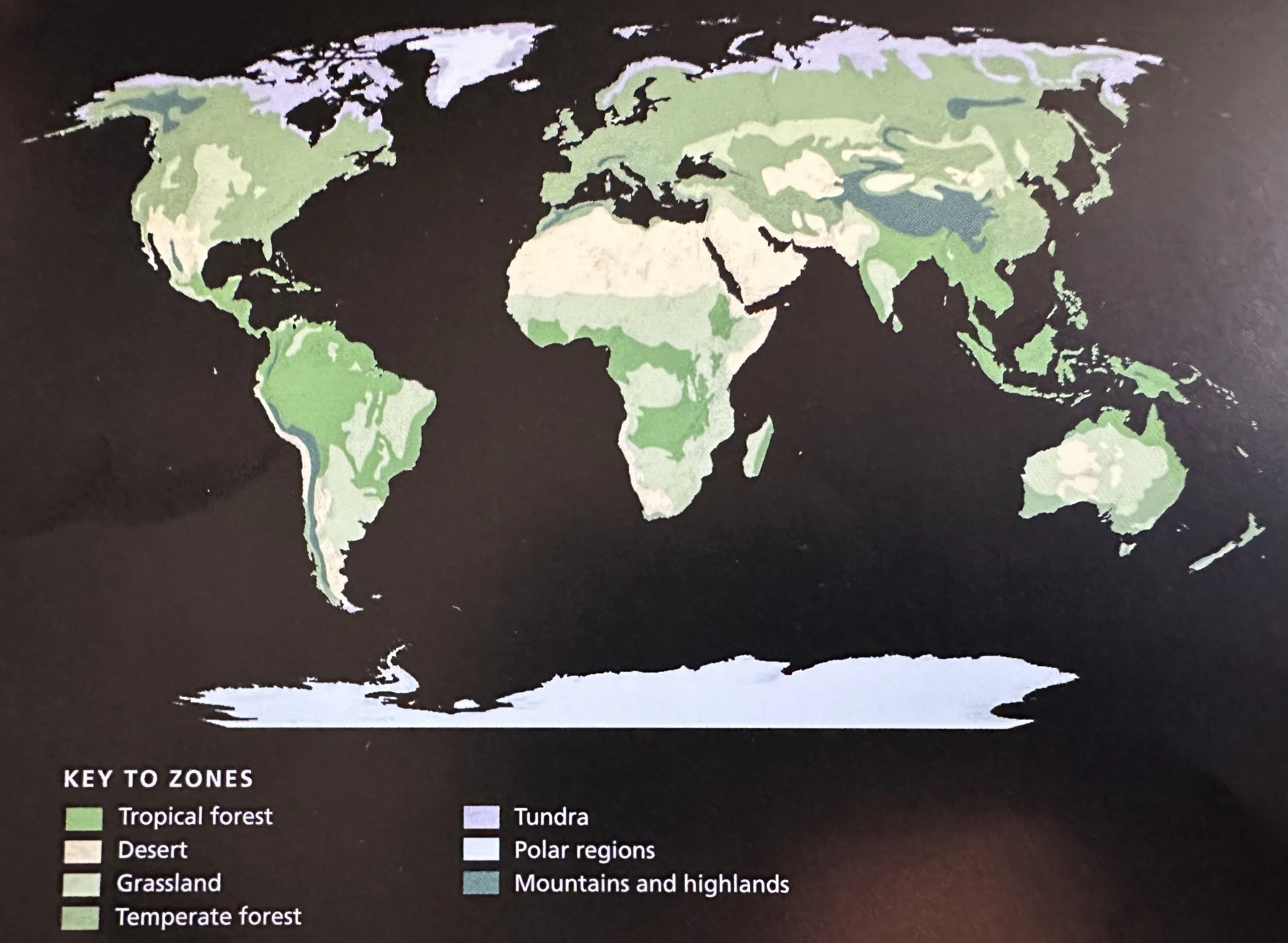
Grasslands: Occur where the climate is too dry for trees, generally in the interior of continents, where the amount of annual precipitation determines the character of the grassland. In North America, for example, tall grass prairie grows in the east, where rainfall is relatively high, and short grass prairie in the drier west. In between is a belt of mixed prairie.
Prairie (Meadow- French): Grasslands of temperate N. America.
Steppe: Grasslands of Eurasia, which extend from eastern Europe to Mongolia.
Pampa: Grasslands of South America.
Veld: Grasslands of South Africa.
Llanos: Grasslands of tropical South America; found wherever the climate is too dry for forest.
Savannah: Grasslands of tropical Africa; the largest grasslands in the world, they extend across the continent to the south of the Sahara, as well as to the south of the tropical forest, and through East Africa.
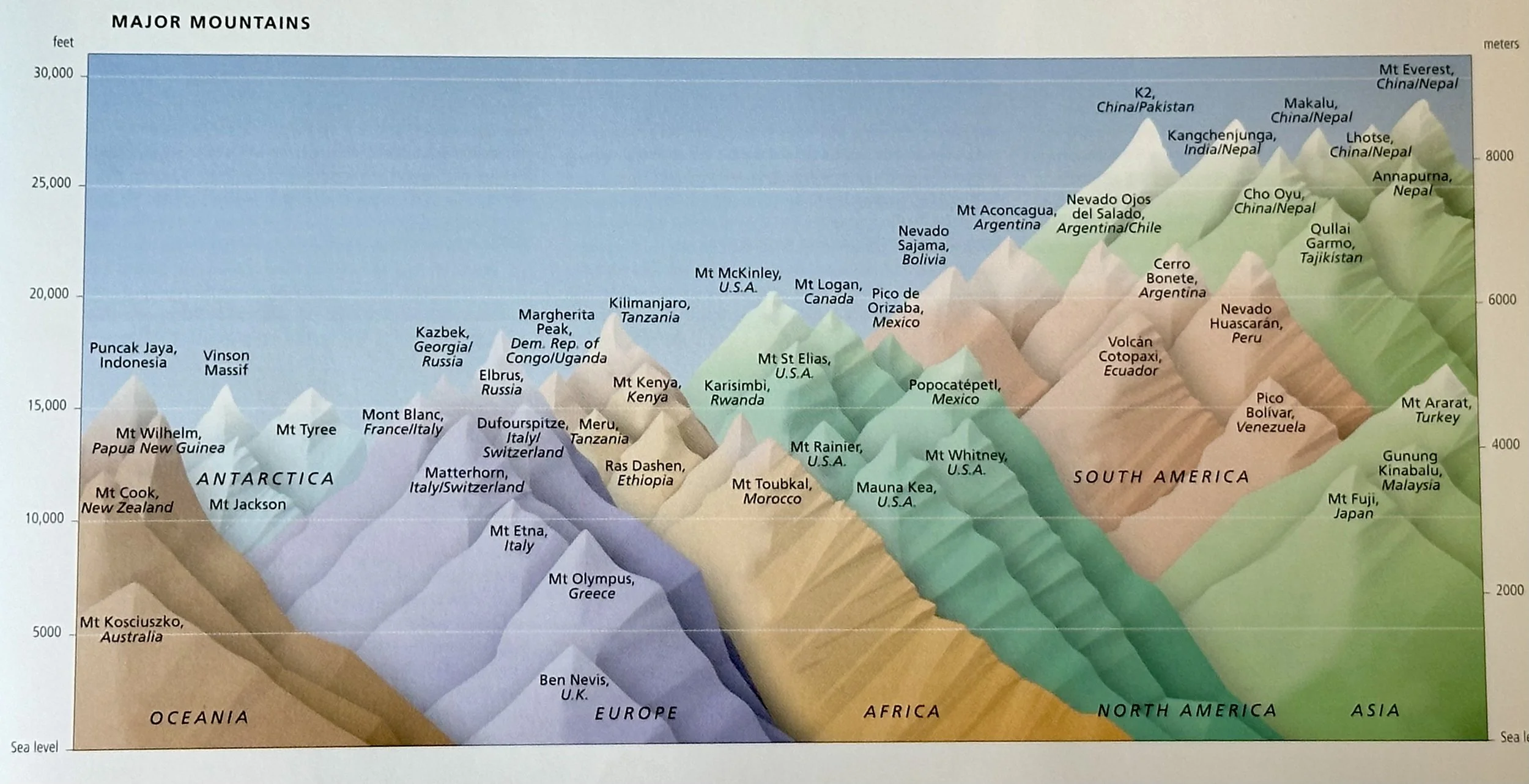
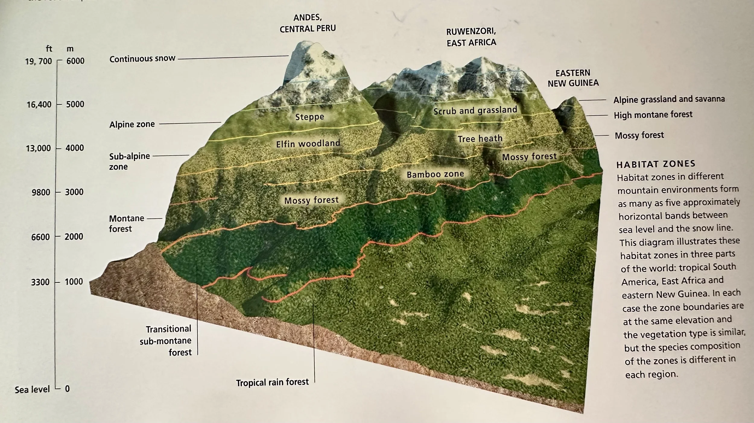
Mountains and Highlands: Alpine environments that provide a variety of habitats that change as greater elevations result in increasingly severe climates. These climatic changes parallel those that occur with increasing distance from the equator. Mountain plants and animals, however, are more closely related to those that live in the lowlands, at the foot of the mountains, than to those found in similarly harsh climates at higher latitudes. At the highest elevations conditions are too severe for trees to survive, and a belt of small, stunted and increasingly widely scattered trees gives way to the treeless zone above the tree line. Higher still there is the snow line, beyond which temperatures remain below freezing all year. The average height of the snow line ranges from sea level in the Antarctic to ~3000 m in middle latitudes, and ~4730 m in the tropics.
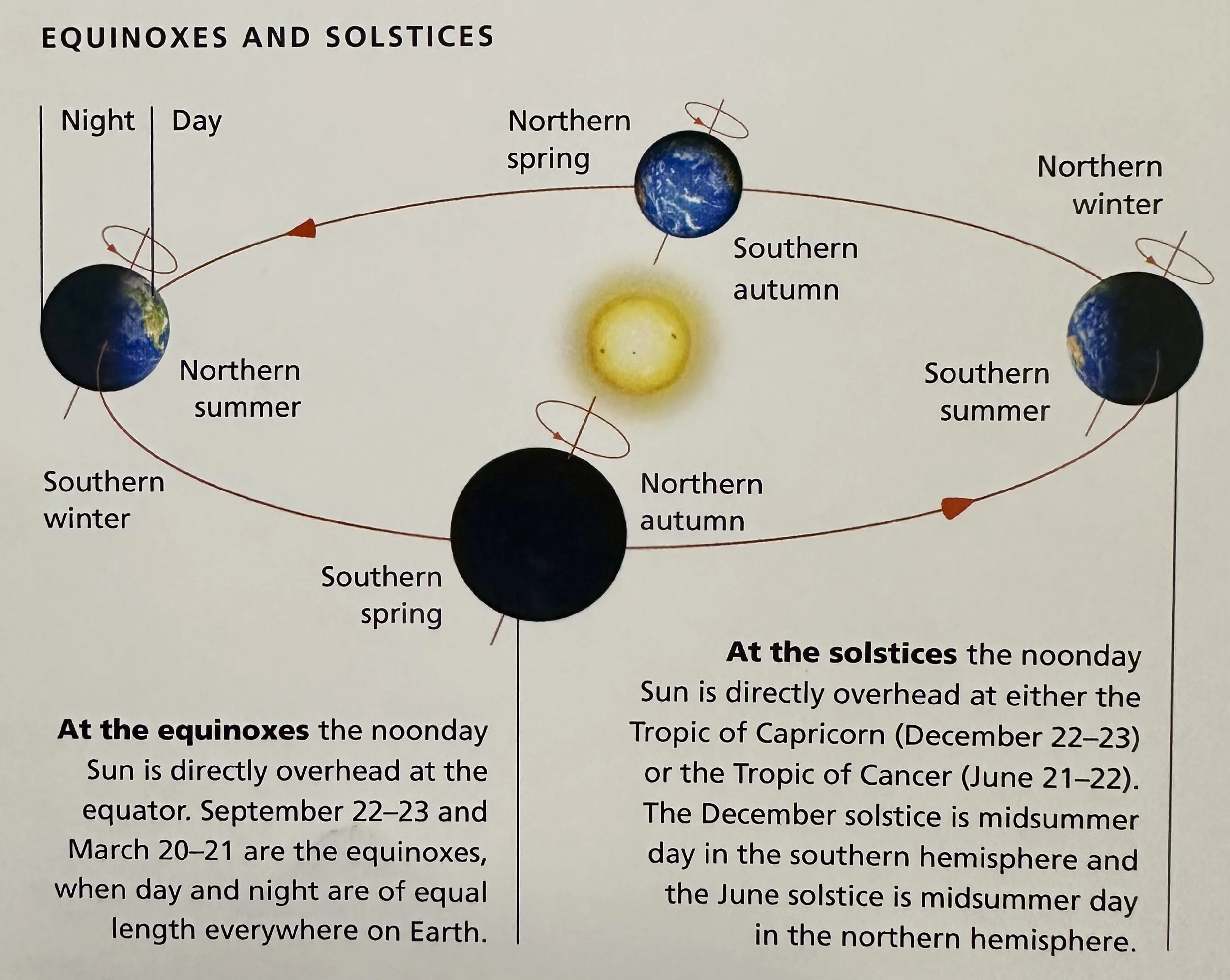
Polar Regions: In the lands beyond the Arctic and Antarctic circles, at 66.5 degrees North and South, there is a period in midwinter when the Sun never rises above the horizon, although some of its light is refracted by the atmosphere to produce a dim twilight. For part of the summer the Sun never sets, though even then it remains low in the sky, moving around the horizon.
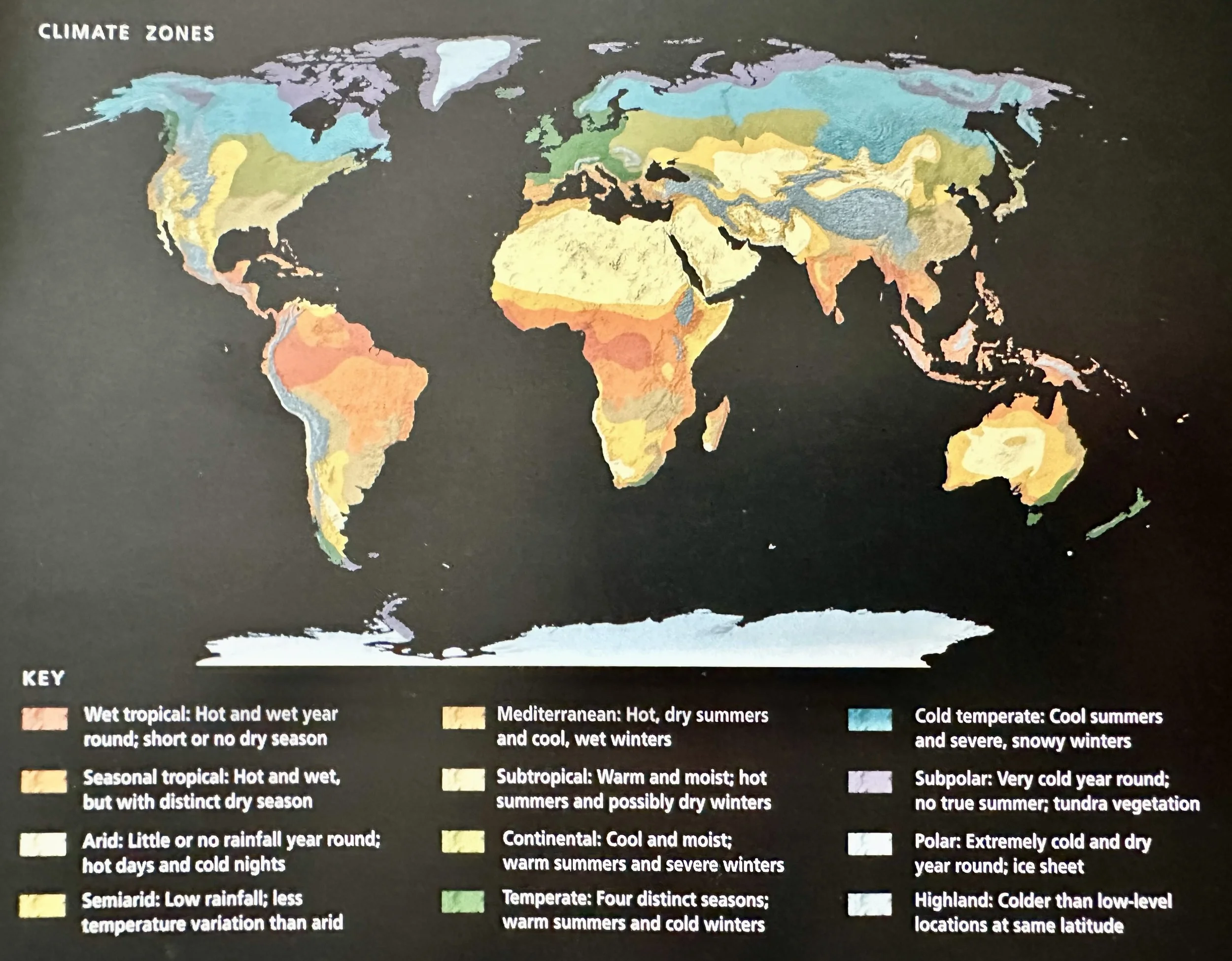
Desert: Dry areas where rainfall < 250 mm per year. Deserts such as the Gobi, in China, form deep inside continents, far from the ocean. Coastal deserts, such as the Namib, in Namibia, and the Atacama, in Chile, form where the prevailing wind crosses the continent to reach them. All deserts are dry, but not all are hot. Despite its thick ice, Antarctica is one of the world's driest deserts.
Savanna: Tropical grassland adapted to a climate with hot summers and pronounced wet and dry seasons.
Steppe: A region of temperate grassland that extends from Eastern Europe across Central Asia. The steppe contains grass an many wild flowers.
Temperate Forest: A biome with a high seasonal temperate climate, with seasons defined mainly by temperatures. Winters are cold, with snow and frozen ground often restricting the water supply to plants. Summers are warm, but seldom hot. Rainfall is distributed fairly evenly through the year. There are several types of temperate forest.
Boreal (‘Northern’) Forest: A type of temperate forest defined by a wide belt of conifer forests that stretch across North America and Eurasia (known as the Taiga in Russia). In Europe and western Russia, it is dominated by spruce (Picea), fir (Abies) and pine (Pinus) species that cast a deep shade. Farther east and in the north larches (Larix) species allow more light to penetrate. Near the edges, and wherever trees have been felled, silver birch (Betula pendula) appears amid the conifers. It does not occur in the southern hemisphere, because there is no land in the relevant latitude.
Broad-Leaved Deciduous (Summer) Forest: A type of temperate forest that grows where summers are longer. Mediterranean climates, found in both hemispheres between latitudes 30 degrees and 45 degrees, support forests of broad-leaved evergreen trees.
Tropical Forests: Grow in equatorial lowlands where the climate is permanently wet and the difference in temperature between day and night is greater than that between summer and winter. It is dominated by broad-leaved evergreen trees >30 m tall and thick lianas. Where the climate is seasonal, with rainy and dry seasons, the tropical seasonal forest contains deciduous trees as well as evergreens. Montane forests grow on tropical mountains. Low-level forests comprise tall trees, but at higher elevations the trees are smaller, and on the highest mountains small, stunted trees form subalpine forest. Belts of permanent mist between 2000-3000 m produce cloud forest, where the trees are covered with mosses and lichens.
Tundra: Close to the Arctic Circle, at 66.5 degrees North, lies a region of biting winds, long, dark winters and short summers with long days. ~3m below the surface the ground remains frozen throughout the year. This is permafrost. It forms a layer up to 600 m thick in parts of AK and >1000 m thick in those parts of Siberia where the ground has still not thawed from the last ice age. Plant roots cannot penetrate the permafrost and in summer, when for a brief time the upper layer-called the active layer-thaws, the ground becomes waterlogged. Apart from dwarf birch (Betula nana) and willow (Salix species), which are about 90 cm tall, no trees grow here. There are sedges (Carex species), rushes (Juncus species) and wood rushes (Luzula species), as well as a few grasses, flowering herbs, mosses and lichens. This vegetation is tundra. Widespread in the northern hemisphere, it occurs in only a few places in the southern hemisphere.
High Arctic Tundra: For most of the year the lands of the high Arctic, beyond the Arctic Circle, are deeply frozen. Ice and snow cover large areas and where it is too dry for snow, icy winds scour the bare rock and loose stones. Plants that survive the extreme cold and aridity do so by producing colorful flowers to attract pollinating insects and by producing seed very quickly. As the days shorten, mountain sorrel (Oxyria digyna) produces new flower buds that remain tightly closed through the winter and open as soon as the days begin to lengthen. Other plants reproduce from small bulbs.
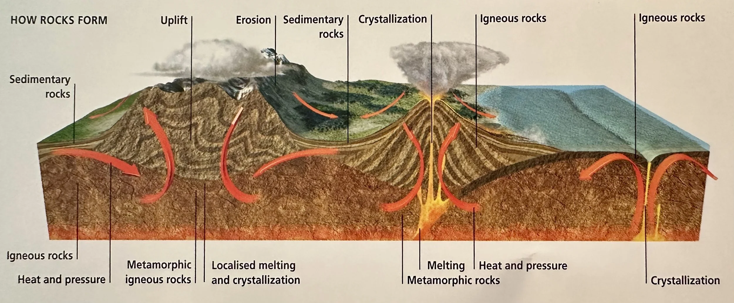
Volcanic Landscapes: An erupting volcano releases lava, ash and pyroclastic flows-clouds of burning gas and ash that advance at terrifying speed and destroy everything in their path. But afterwards, as the surface cools, the volcanic material weathers and matures into rich soil that supports plants of every kind and that also produces abundant farm crops. Eruptions are rare events and between them people settle on the lower slopes of volcanoes and farm their fertile soils. Many volcanoes eventually die, and extinct volcanoes provide the structure for some of the most beautiful and productive landscapes.
Wetlands: Waterlogged areas of land on low-lying ground beside rivers and river estuaries, in deltas and along some coastlines, either permanently or for part of the year. They include marshes, bogs, fens, peatlands and swamps, as well as shallow lakes and ponds. Wetlands are often attractive sites for development. Some can be drained for conversion to farmland or forest, others developed for tourism. Their survival is severely threatened everywhere.
___________________________________________________________________________
Weather & Climate
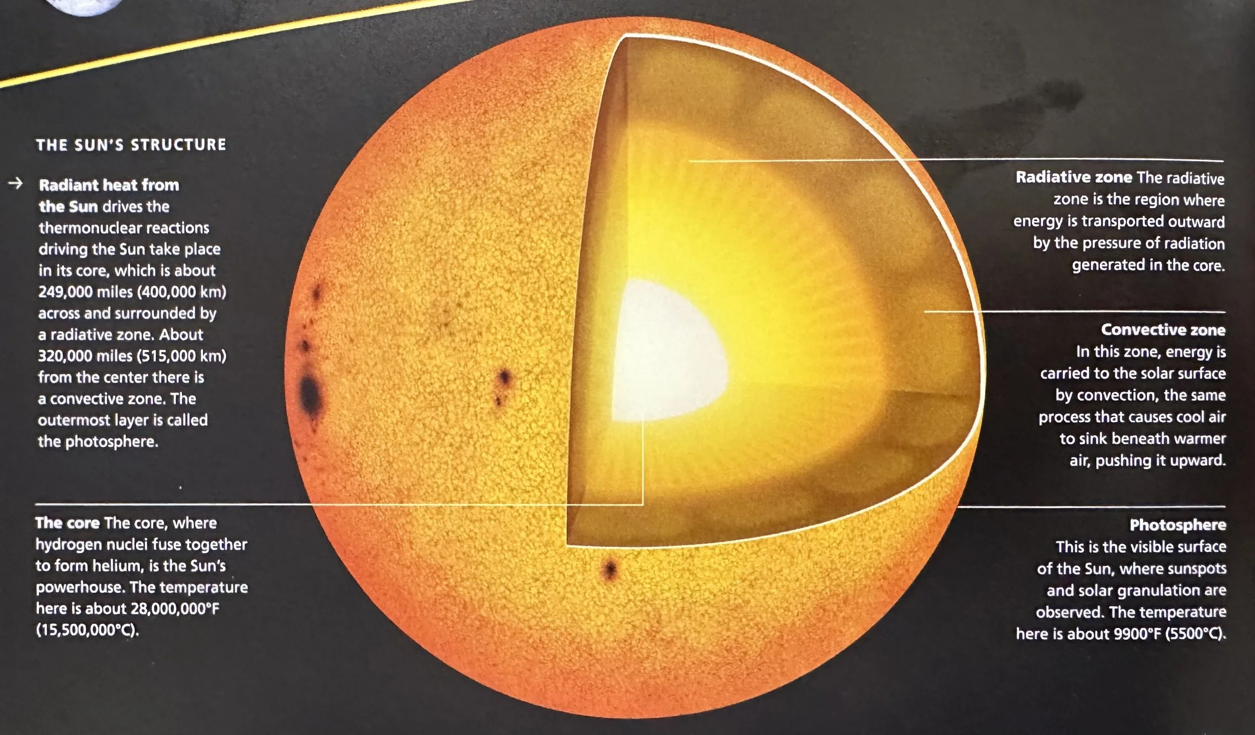
Radiant heat from the sun drives the atmospheric processes that produce the worlds climates and day-day weather. The Sun's heat and light power the chemical reactions on which all life depends.
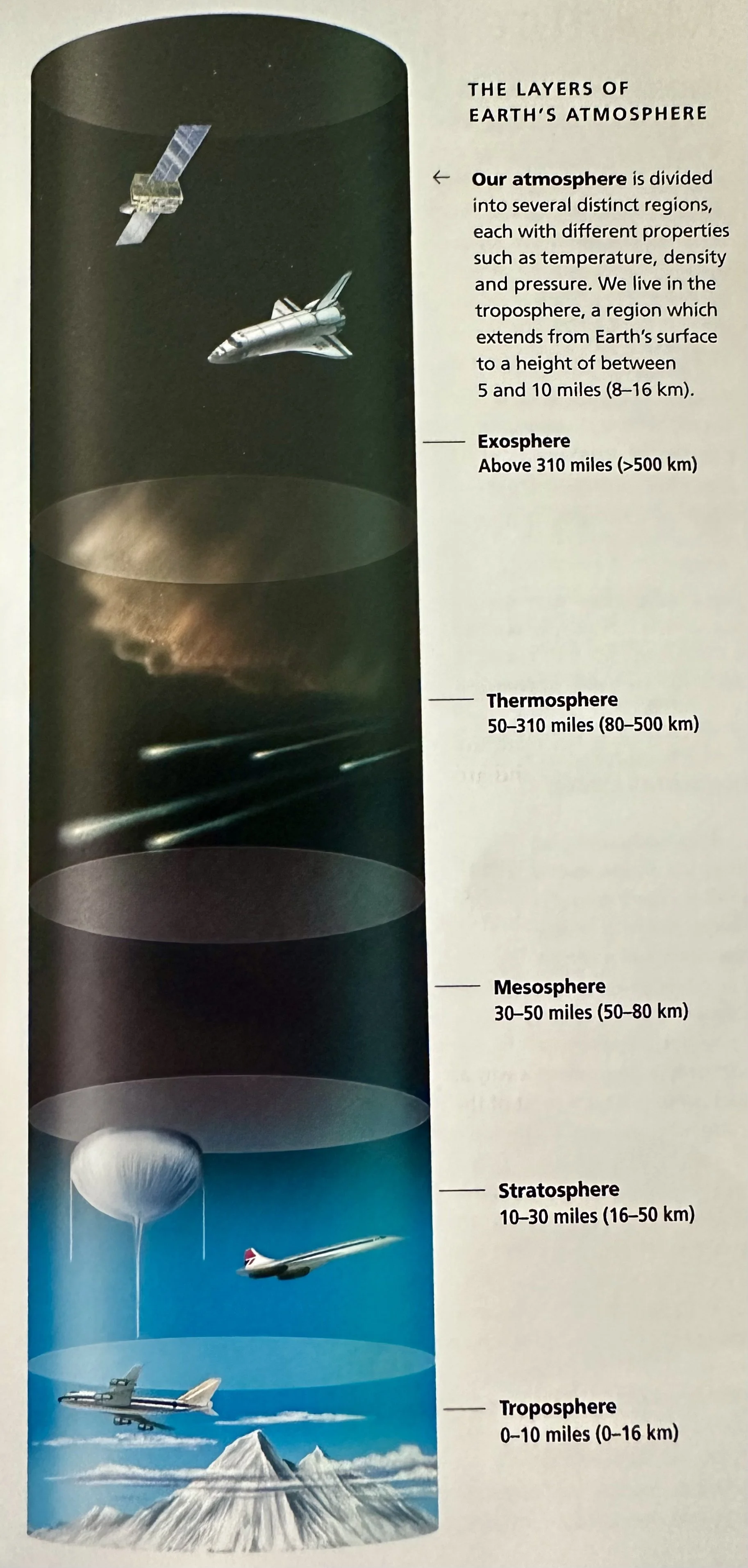
Earth's atmosphere extends from the surface to the edge of interplanetary space, where it merges with the Sun's atmosphere. At that height, in the exosphere, the air is so thin that gas molecules and atoms rarely collide. Increasing height within the atmosphere brings a decrease in temperature; as sunshine warms Earth's surface, air is heated from below, by contact with the warm land and sea. The temperature does not decrease evenly, however, and there are regions where it stays constant or even rises at higher altitudes. These differences produce boundaries that rising air cannot easily cross; as a result, they divide the atmosphere into layers. In the two lowest layers-the troposphere and stratosphere- air is composed of 78.08% N, 20.95% O, 0.93% Ar, and there are traces of other gases. This region is sometimes called the homosphere. Above it, in the heterosphere, the composition changes with height. N is predominant at lower levels, together with molecular (O2) and atomic (O) Oxygen. Above that, atomic O is mixed with molecular (N2) and atomic (N) Nitrogen.
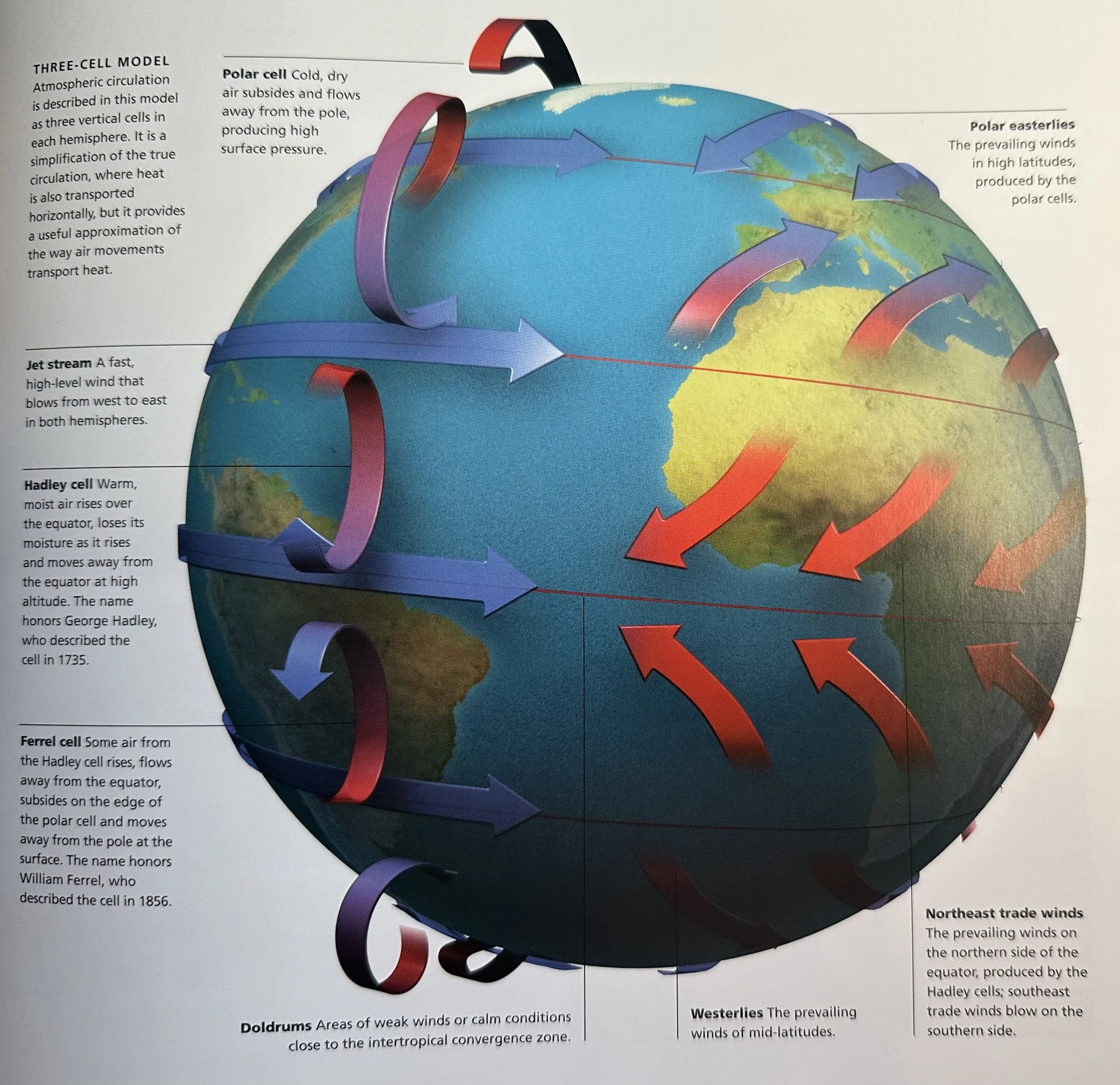
Atmospheric Circulation: Warm air rises and cold air subsides, and the Sun shines more strongly over the equator than over the poles. These facts combine to produce a constant movement of air throughout the troposphere- a general circulation of the atmosphere that has the overall effect of transporting heat away from the equator. The discovery of this convective system began as scholars tried to explain the constancy of the NE and SE trade winds that blow on either side of the equator. In 1735 George Hadley (1685-1768) proposed that warm air rises over the equator, cools, sinks over the poles and flows back toward the equator as a surface wind that is deflected by Earth's rotation. It is more complicated than that, but his mechanism does operate in the tropics, producing the Hadley cells. A second set of cells, the polar cells, combine with the Hadley cells to drive a third set, the Ferrel cells, which were described by William Ferrel (1817-91) in 1856.
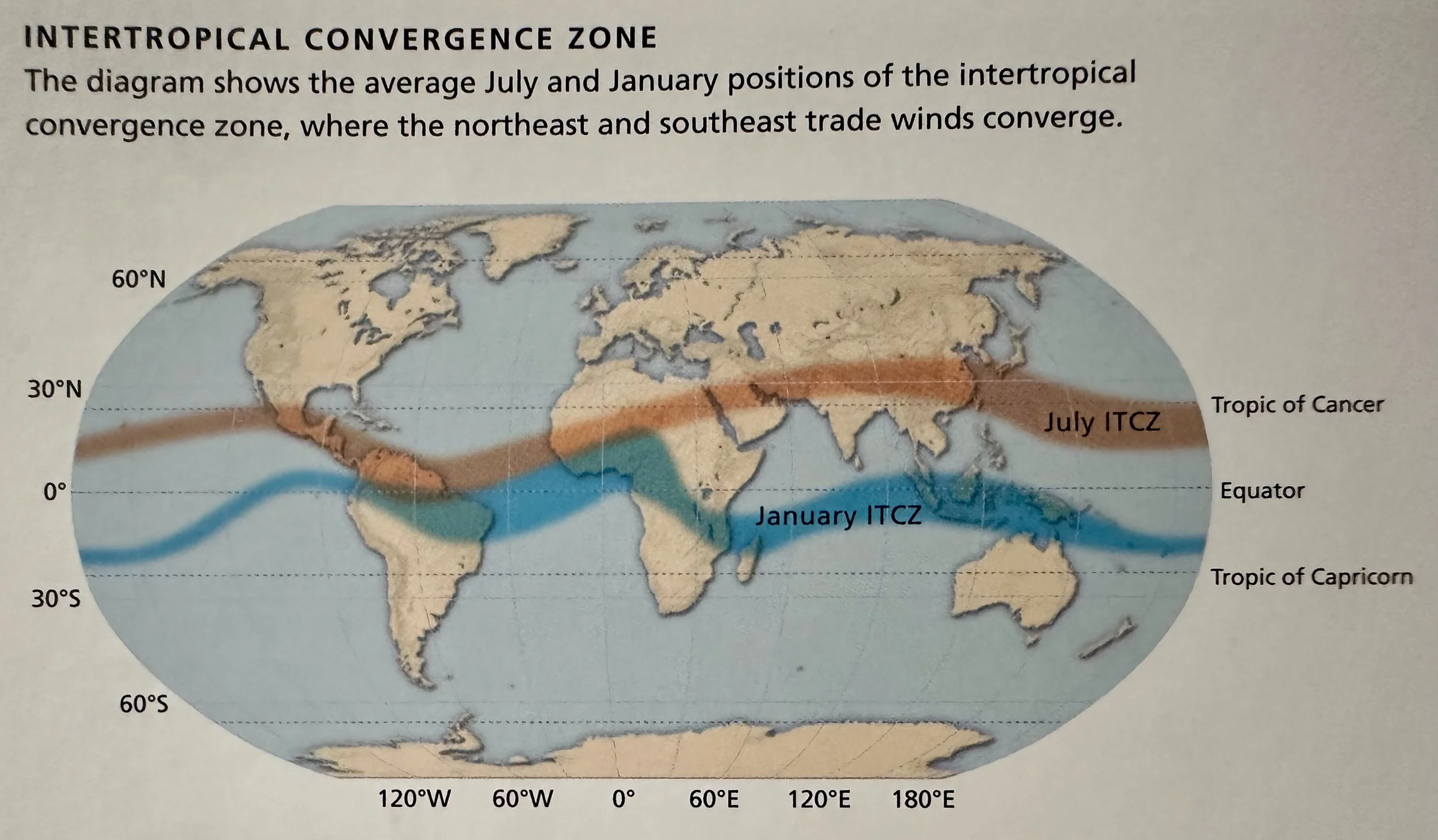
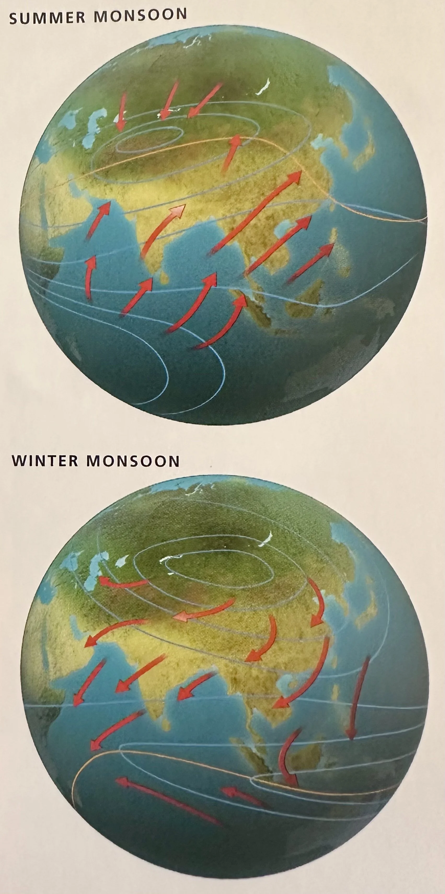
Monsoon: From ‘mausim’, Arabic for ‘season’; impact tropical Asia Africa, Australia, Mexico and the SW US. There are two monsoon seasons; both are associated with the direction of the prevailing winds. During winter monsoons, prevailing winds blow from the center of a large continent, bringing dry air. Mumbai, in India, receives on average only 102 mm of rain from October until May. This is the dry, winter monsoon. Then the wind direction reverses and moist air flows in from across the ocean. Between June and September, 1702 mm of rain fall on Mumbai. This is the wet, summer monsoon.
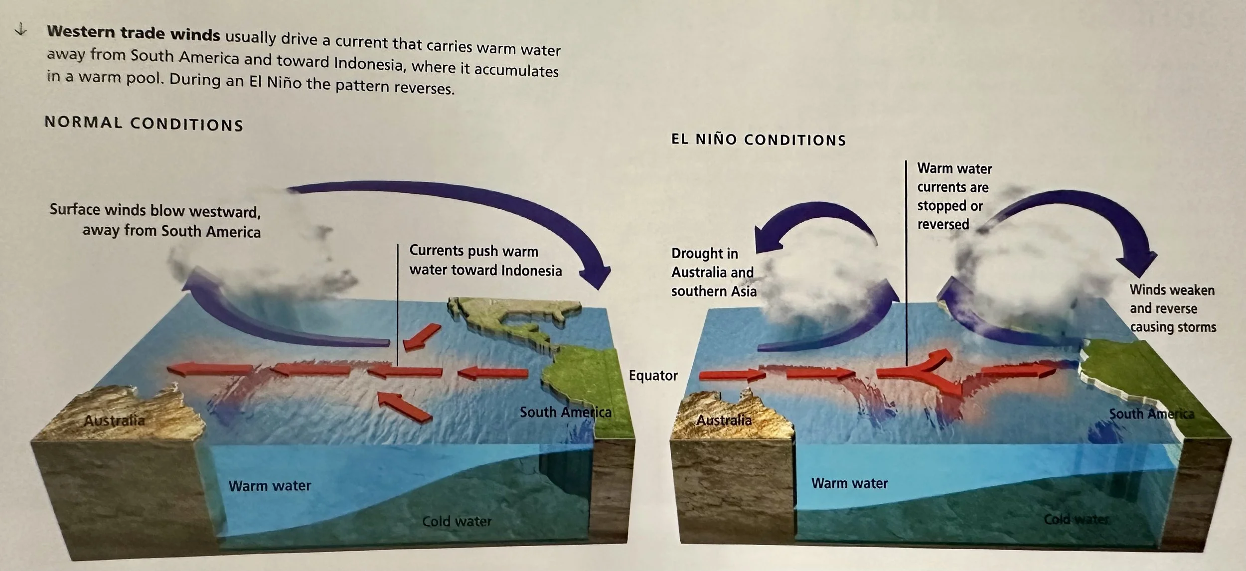
El Niño: A change in wind and rainfall patterns that happens every few years. It begins in the tropical S. Pacific but affects a much larger area. It is linked to changes in pressure distribution, called a southern oscillation, which weakens or reverses the trade winds and the ocean currents that drive warm water westward.
The Fujita Scale
F0: 64-117 kph winds with light damage.
F1: 118-180 kph winds with moderate damage.
F2: 181-251 kph winds with considerable damage.
F3: 252-330 kph winds with severe damage.
F4: 331-417 kph winds devastating damage.
F5: >417 kph winds with incredible damage.
Thunder and Lightning: Conditions inside a giant cumulonimbus cloud are violent. Warm air rises in currents that move at up to 160 km/h. When it reaches the top of the cloud the air subsides in downcurrents. These leave the cloud base as downdrafts, producing wind gusts often of gale force. The downcurrents carry snowflakes and raindrops, each surrounded by an envelope of cold air. Eventually this chills adjacent upcurrents, they lose energy and the cloud dissipates. During its active phase, the cloud accumulates positive electric charge in its upper layers and negative charge near its base. Small ice crystals and water droplets carry positive charge and the larger snowflakes and droplets carry negative charge- gravity separates the charges. The low-level negative charge induces a positive charge on the ground surface. Natural radiation, including cosmic radiation, releases free electrons that accelerate in the strong electrical field and become an avalanche that turns into a lightning flash.
Anticyclones: Areas of high surface pressure. Air inside them subsides and circulates clockwise in the N. hemisphere and counterclockwise in the S. hemisphere. Anticyclones bring light winds and fine weather. The evaporation of surface moisture can produce small cumulus clouds- fair weather cumulus.
Cyclones: Areas of low surface pressure in which air rises and turns cyclonically (CCW) in the N. hemisphere and clockwise in the S. hemisphere- about a low-pressure center. Winds may be strong. The air is relatively warm and if it is moist, layers of stratus, stratocumulus, nimbostratus, altostratus and cirrostratus cloud will form, bringing dull, overcast skies, often with persistent precipitation.
Rain: The amount of water vapor air can hold depends on the temperature. Cold air can hold less than warm air, and if the temperature of moist air falls to below a critical value, called the dew point, some of its water vapor will condense- provided there are surfaces for it to condense onto. Suitable surfaces are provided by minute particles called cloud condensation nuclei. These consist of dust, salt crystals and, best of all, droplets of sulfuric acid. Sulfuric acid forms from sulfate molecules by reactions that involve cosmic radiation. Cosmic rays play a crucial role in the formation of low-level clouds. High-level clouds consist of ice crystals, formed when water vapor freezes directly onto freezing nuclei. Cloud droplets grow into raindrops either by colliding and coalescing as they fall, or by freezing into crystals that join together as snowflakes and then melt as they fall into warmer air. Droplets fall as rain when they grow too heavy for the updrafts in the cloud to support them. They begin to evaporate the moment they enter the drier air below the cloud.
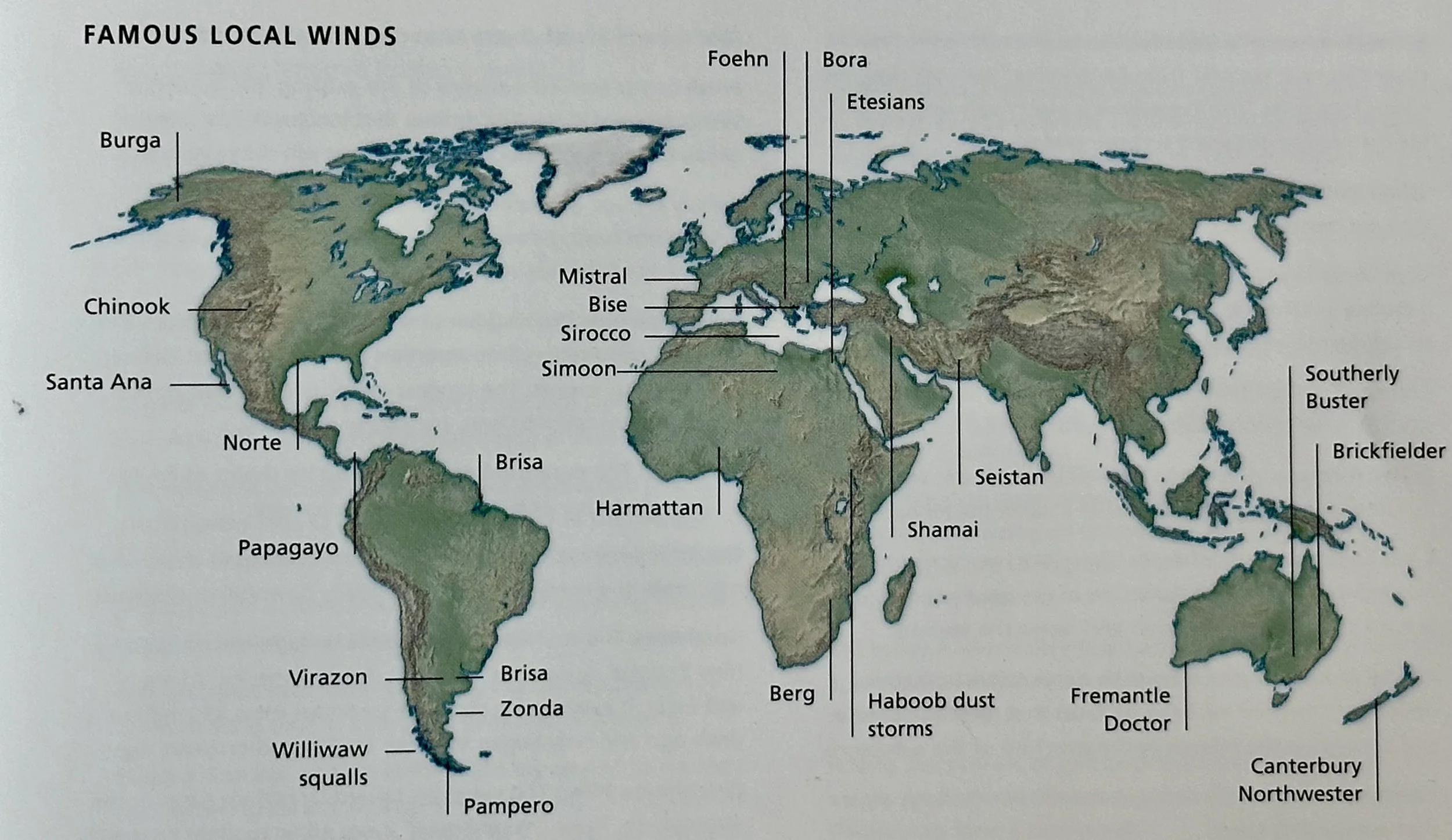
Wind: Relatively cool and dense air produces high surface pressure. Warmer and less dense air results in low pressure. The difference in pressure between adjacent areas of high and low pressure constitutes a pressure gradient that exerts a pressure-gradient force (PGF), which pushes air toward the center of low pressure at a speed proportional to the gradient. Wind is that air movement. Earth, however, also moves beneath the moving air, and this deflects the air to the right in the N. hemisphere and to the left in the S. hemisphere due to the Coriolis force (CorF). The magnitude of the CorF varies according to the latitude and speed of air movement. The PGF and CorF balance each other when the air follows a circular path around the centers of high and low pressure. The general circulation of the atmosphere produces prevailing winds, the most constant being the E. trade winds of the tropics.
Tufa: A CaCO3 that is precipitated under extremely alkaline conditions.
Radiation Fog: Occurs when the night is clear and the ground radiated away the heat it absorbed during the day. As the surface temperature fell, the air next to the ground chilled to below its dew point temperature. Water vapor condensed and by morning a thin layer of fog covers the ground.
Rainbow: Shows that a rainstorm has passed. Bright sunlight shining from behind the observer is refracted as it enters water droplets, then reflected from the rear of the droplets and refracted a second time as it leaves. This breaks white light into its constituent colors, with red on the outside.
Drought: A prolonged period with less rain than usual for a place and time of year
Dust Devil: Occurs when local surface heating makes air rise, drawing in cooler air from the sides. As the incoming winds meet, the air begins to turn. It spirals wildly upward, carrying dust, leaves, scraps of paper and other loose debris with it. The incoming air cools the surface, and the devil dies down after a few minutes.
___________________________________________________________________________
Species
Arctic Tern (Sterna paradisaea): A bird species that conducts the longest bird migration. It breeds north of the Arctic Circle then flies ~15,000 km across the Atlantic to Antarctica. It migrates north again as the Antarctic winter approaches.
Zebra Mussels (Dreissena polymorpha): An invasive species native to the Caspian and Black seas and Russian freshwater lakes. They appeared in the Netherlands in 1827 and have become highly invasive in Europe and in North America, where they were first seen in 1986.
___________________________________________________________________________
Chronology
2005: Discovery of the dwarf-planet Eris, a body slightly larger than Pluto (Earth by Allaby).
1990: Carl Woese proposes a new classification based on three domains: Bacteria (or Eubacteria), Archaea and Eukaryota (or Eukarya). This is now widely used. The domain Bacteria comprises all bacteria, including cyanobacteria, in the kingdom also called Bacteria. Archaea comprises two kingdoms: Crenarchaeota-extreme heat- and cold-loving organisms; and Euryarchaeota- organisms that live in other extreme environments. The domain Eukaryota contains the kingdoms Protoctista, Fungi, Plantae and Animalia (Earth by Allaby).
18 May, 1980: Volcanic eruption of Mount Saint Helens. Inactive for centuries, it is destabilized by an earthquake, which collapses the north face of the mountain, thereby reducing pressure on the underlying magma chamber. The eruption destroys ~595 sqkm of forest (Earth by Allaby).
1976: An earthquake strikes Tangshan, China killing 655,237 (Earth by Allaby).
1971: The Ramsar Convention is held in Iran; delegates agree to protect designated wetlands of international significance, especially those important to water birds. By 2007, 154 governments had signed the Ramsar Convention, and 1650 sites, covering 149.6M hA had been listed and protected (Earth by Allaby).
1971: Completion of the Aswan High Dam on the Nile River; the dam wall is 3.8km long, 111m high, and 1000m thick. The hydroelectric plant inside the wall supplies almost half of Egypt’s electricity (Earth by Allaby).
1960: Jacques Piccard and Don Walsh descend aboard the submersible ‘Trieste’, to the bottom of Challenger Deep in the Pacific Ocean; a depth of 11,530m (Earth by Allaby).
1959: Soviet Probe Luna 3 first records the far side of the moon (Earth by Allaby).
1938: Flooding in Huang He, China kills ~500-900K people (Earth by Allaby).
1936: Extinction of the Tasmanian wolf (Thylacinus cynocephalus). By 1850 it seemed endangered, but despite this, in 1888 the Tasmanian government introduced its own bounty. The last survivor was captured in 1933 and died 3 years later in a Hobart Zoo (Earth by Allaby).
1931: Flooding in Huang He, China kills ~1-3.7M people (Earth by Allaby).
1905: Evidence for the Cambrian explosion is discovered in the Burgess Shale, rocks in BC, Canada (Earth by Allaby).
1902: The volcanic eruption of Mt. Pelee, Martinique; ~28K die from mudflows (Earth by Allaby).
1887: Flooding in Huang He, China kills ~900K-2M people (Earth by Allaby).
1883: A tsunami strikes the Sanriku Coast of Japan, killing ~20K (Earth by Allaby).
1883: A tsunami caused by the volcanic eruption of Krakatau, Indonesia, kills ~36K (Earth by Allaby).
1876: An earthquake strikes Andaman Islands, India killing ~215K (Earth by Allaby).
1815: The volcanic eruption of Tambora, Indonesia; ~92K die from ash, tsunamis, disease, and starvation (Earth by Allaby).
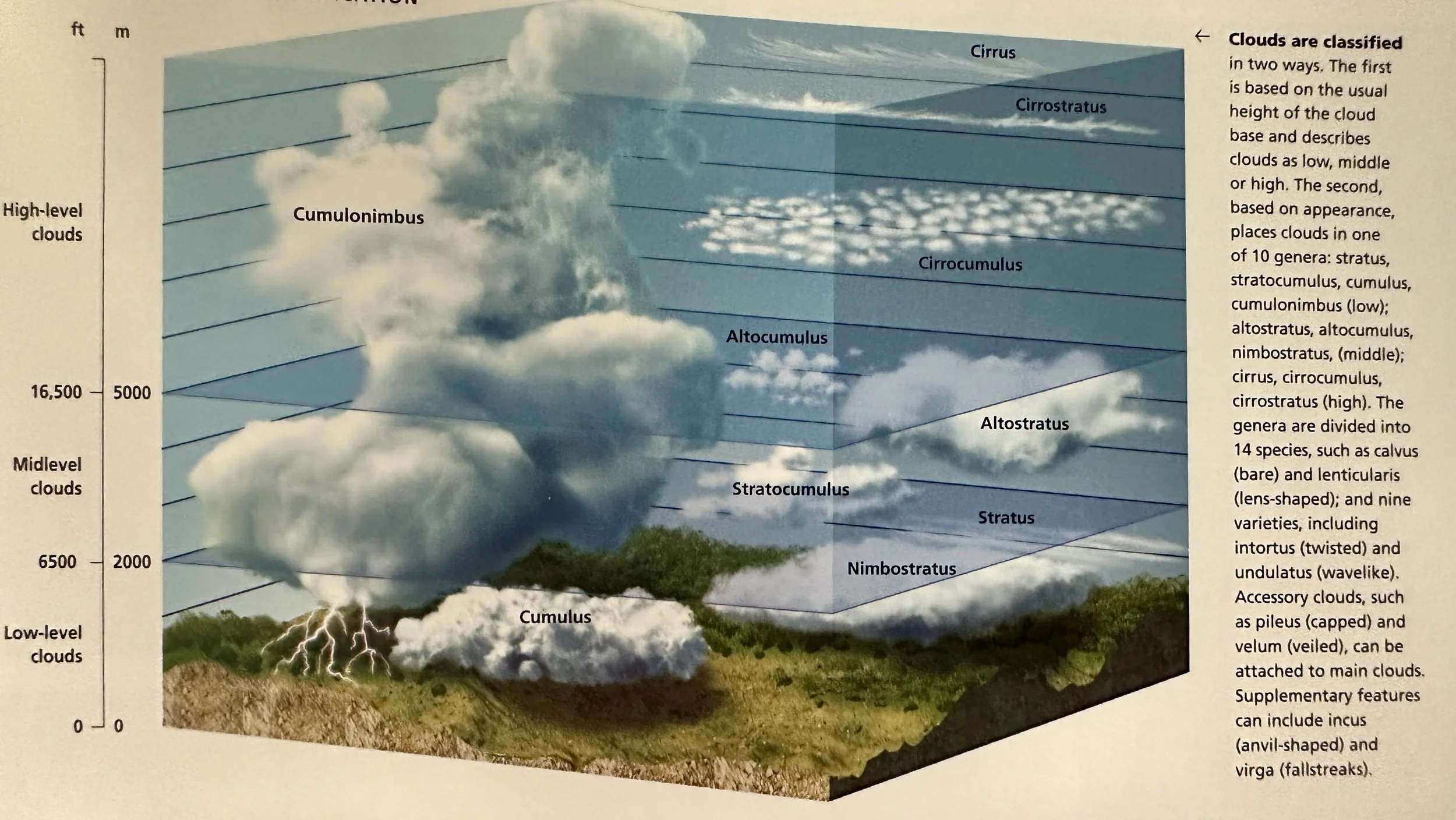
1803: Luke Howard, (1772-1864) an English pharmacist and amateur meteorologist, devises a system of cloud classification, that, with some later modifications, is still used today. Howard proposed that all clouds can be described in terms of four basic types: cumulus (heaped), stratus (layered), cirrus (wispy) and nimbus (producing precipitation). In 1896, Howard's system was adopted for the first edition of the International Cloud Atlas. Now published by the World Meteorological Organization, the Atlas still uses these universally accepted descriptions (Earth by Allaby).
1792: A tsunami strikes Kyushu, Japan, killing ~5K (Earth by Allaby).
1771: A tsunami strikes Okinawa, Japan, killing ~12K (Earth by Allaby).
1737: An earthquake strikes Calcutta, India killing ~300K (Earth by Allaby).
1662: An earthquake strikes China killing ~300K (Earth by Allaby).
1556: An earthquake strikes Shanxi, China killing ~830K (Earth by Allaby).
1201: An earthquake strikes Egypt-Syria killing ~1.1M (Earth by Allaby).
1139: An earthquake strikes the Caucasus killing ~300K (Earth by Allaby).
1139: An earthquake strikes Aleppo, Syria killing ~230K (Earth by Allaby).
856: An earthquake strikes Iran killing ~200K (Earth by Allaby).
115: An earthquake strikes Antioch, Turkey killing ~260K (Earth by Allaby).
~5760 BCE: Last eruption of the Chaîne des Puys volcanoes in the Auvergne region of Central France (Earth by Allaby).
100 Ka: Modern humans first migrate out of Africa (Earth by Allaby).
1.7 Ma: An asteroid strikes Earth near Wiluna, W. Australia, forming the 30 km diameter Shoemaker Crater (‘Teague Ring’) (Earth by Allaby).
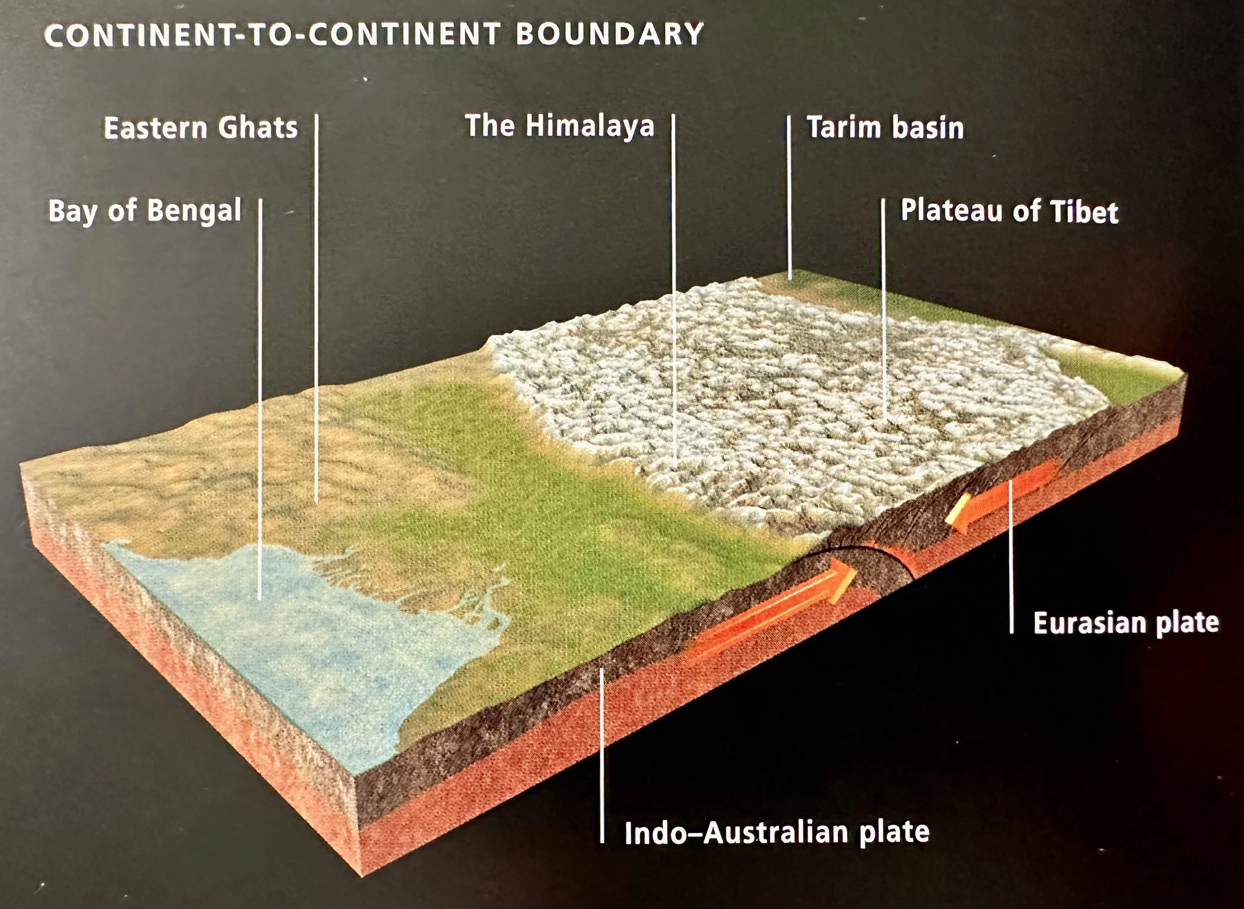
30 Ma: Orogenesis of the Himalayas; India, traveling northward, collides with the southern edge of the Eurasian plate. The main episode of mountain building occurred ~20 Ma, but the plate collision has not ended and the mountains are still growing taller (Earth by Allaby).
~145 Ma, the Indo-Australian plate broke away from the supercontinent of Gondwana. As it moved northward, the section of the Tethys Sea between India and Eurasia disappeared. When the plates collided, India thrust beneath Eurasia. Seabed sediments were compressed and pushed upward and the plates crumpled, raising the Himalayas (Earth by Allaby).
~400 Ma: Evolution of Ammonites (Earth by Allaby).
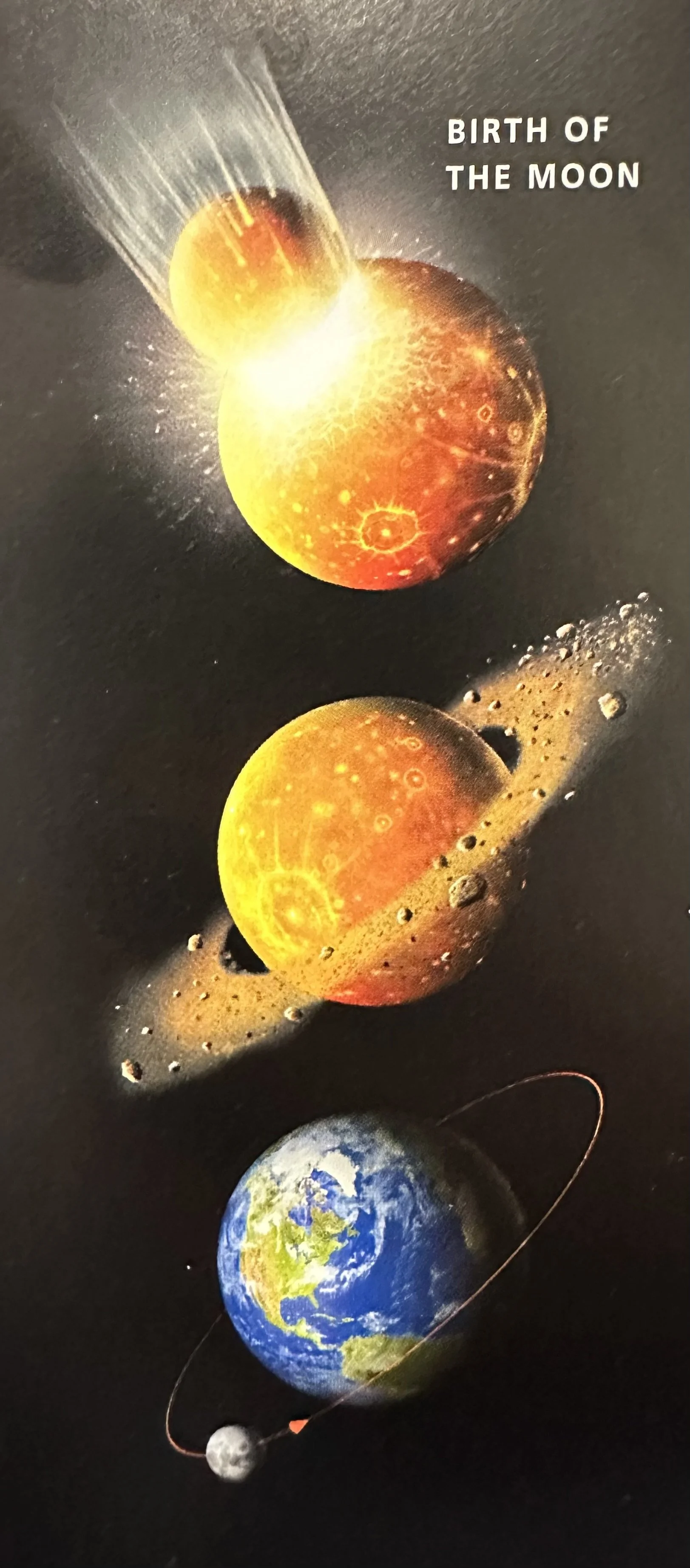
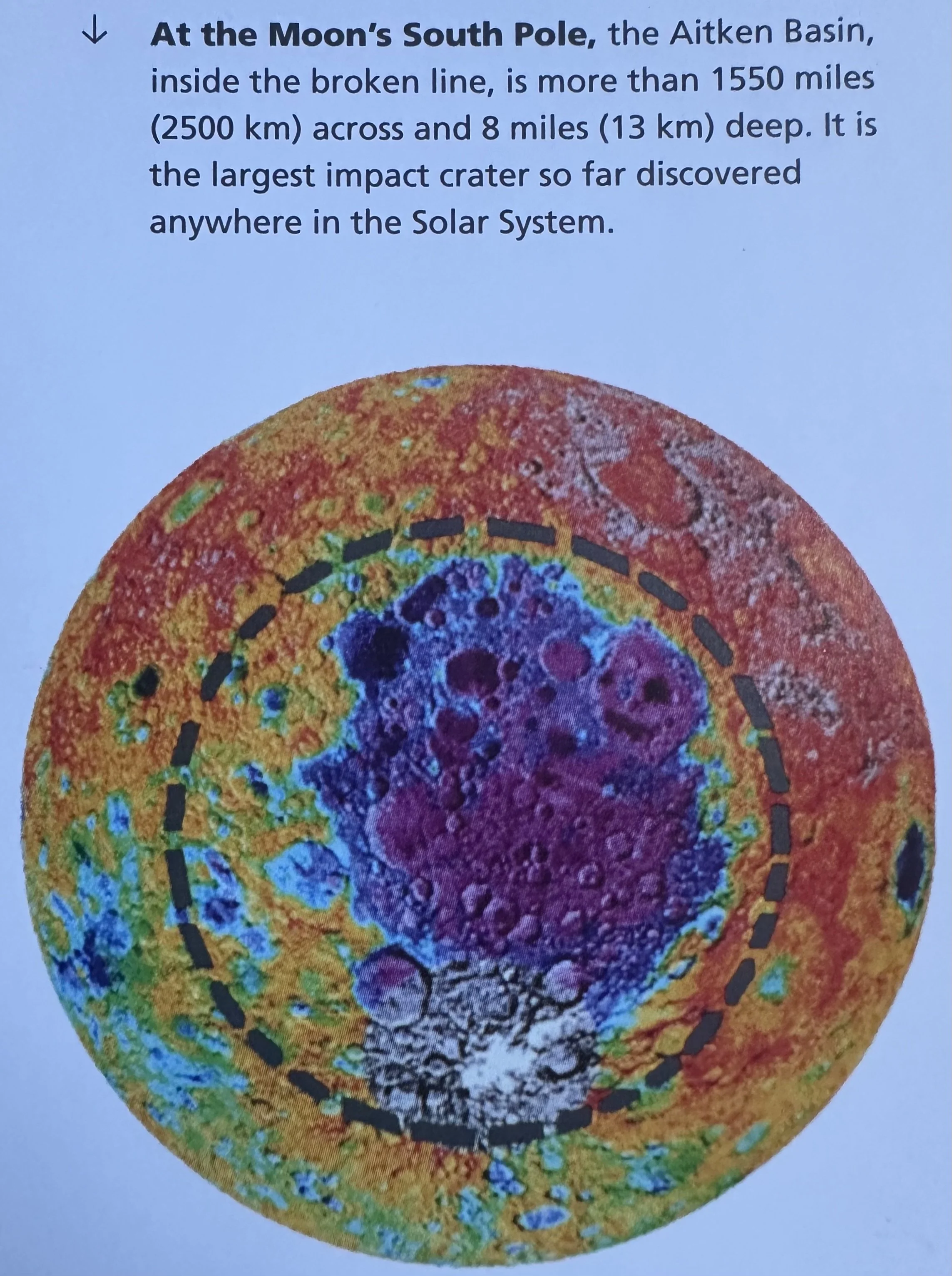
4.5 Ga: Birth of the moon after a large proto-planet the size of Mars strikes Earth (Earth by Allaby).
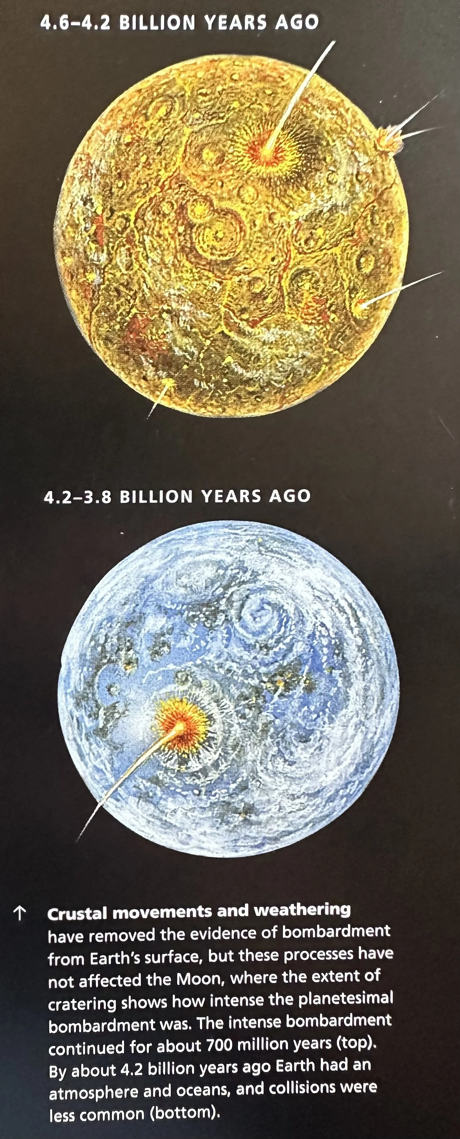
4.5-4.2 Ga: Early bombardment; Earth is struck by endless asteroids and meteors (Earth by Allaby).
___________________________________________________________________________
