Volcanoes in the Sea by MacDonald
Ref: Macdonald, Abbott, Peterson (1983). Volcanoes in the Sea: The Geology of Hawaii. University of Hawaii Press.
__________________________________________________________________________________
Summary
How were the great Hawaiian mountains formed? And what processes have shaped the ridges and valleys today? These are the questions which this book attempts to answer.
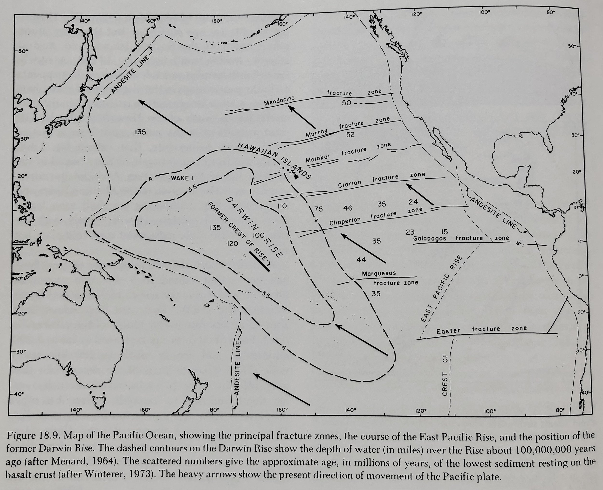
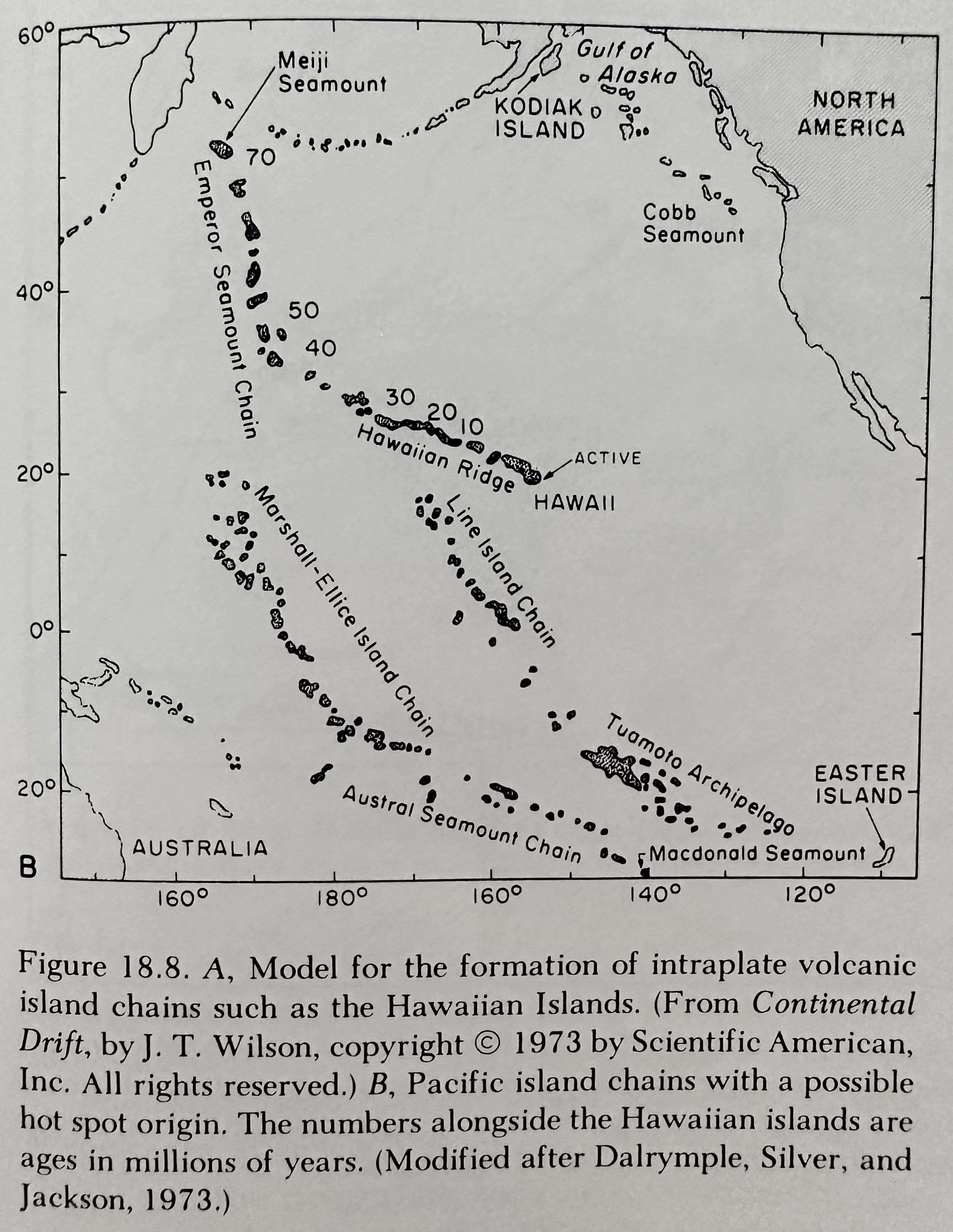
Hot Spot Theory: A source of heat (hot spot) deep within the earth continually generates new magma (molten rock) which feeds the Hawaiian volcanoes; Hawaii’s hot spot has remained relatively stationary for many millions of years, while the Pacific plate on which the Hawaiian Islands sit, has slowly moved over it.
__________________________________________________________________________________
Hawaiian Volcanic Activity
Hawaiian Hot Spot: ~300km across with multiple (at least two) loci that can erupt simultaneously. One line of volcanic centers includes Kauai, Waianae, Koolau, W. Molokai, Lanai, Kahoolawe, Hualailai, Mauna Loa, and now Loihi. The other connects E. Molokai, W. Maui, Haleakala, Kohala, Mauna Kea, and Kilauea.
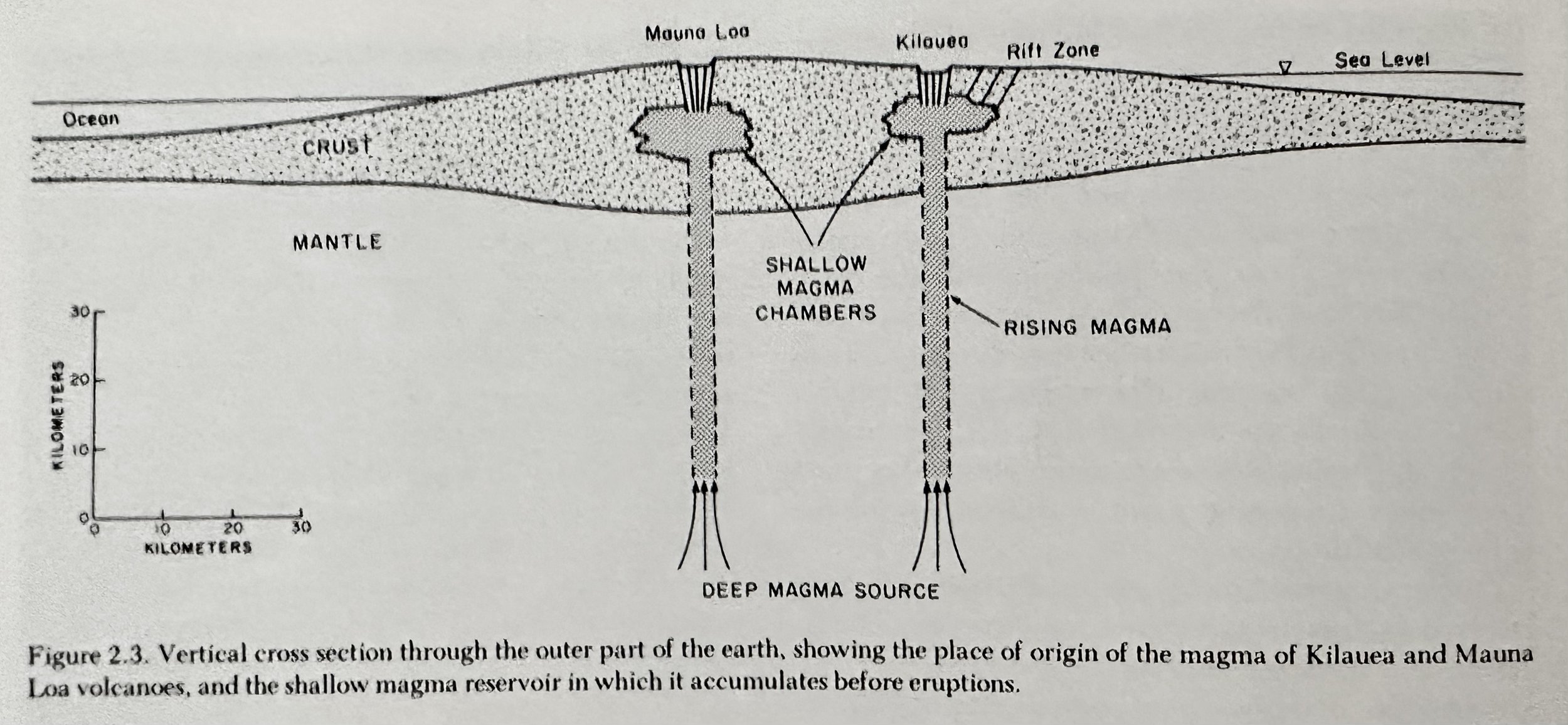
Magma Chamber: Chambers lie ~50-80km below the volcano summit. Magma moves upward through a roughly cylindrical conduit to a shallow magma reservoir ~2-5km below the surface. In this relatively cooler region, the magma loses heat to the surrounding rocks, and as it becomes cooler solid crystals of minerals, first olivine, begin to firm. As the magma enters the zone of low pressure close the Earth’s surface, gas begins to bubble out of solution within the magma. As the reservoir becomes filled it swells, causing noticeable inflation of the summit area. In some cases, however, the pressure forcing the magma upward apparently is not sufficient to push to all the way to the surface, and in these instances, an intrusion occurs.
Tumescence: Doming of the crust above an expanding or rising magma.
Volcano: A place where molten rock (magma) and/or gas from within the earth issues at the surface.
Fumaroles: Vents from which hot volcanic gases (generally Sulfur and solfataras) issue unaccompanied by liquid or solid matters.
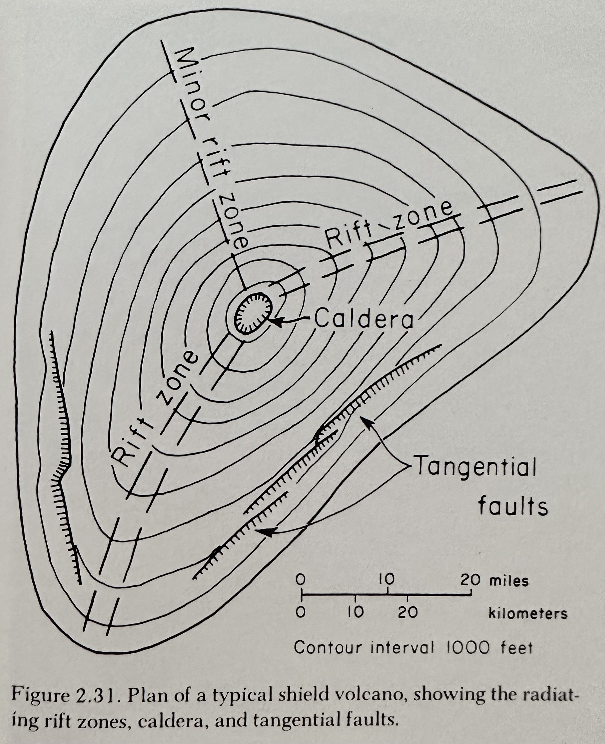
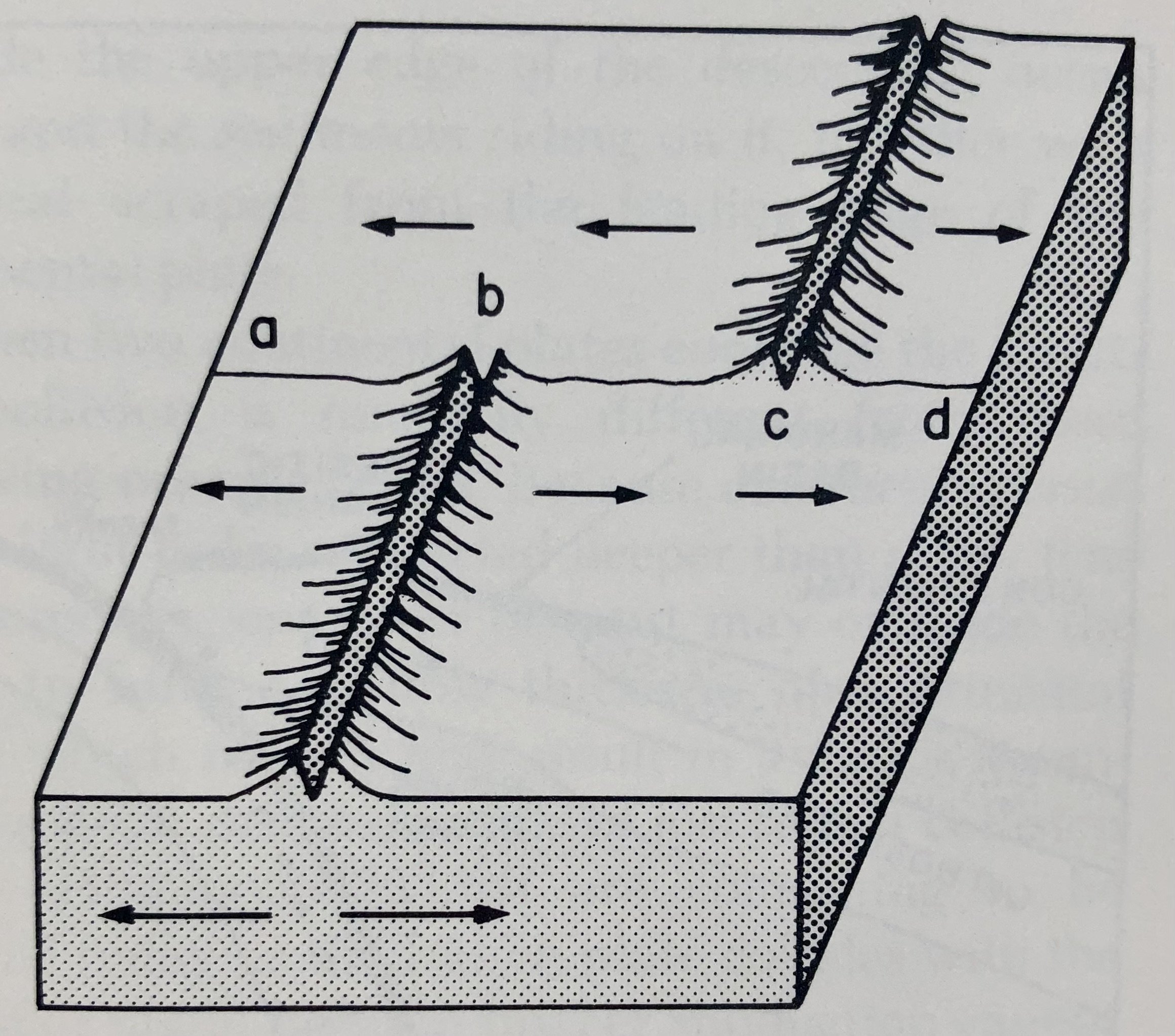
Rift Zones: Extensive zones of cracks that provide passageway for the rising magma.
Volcanic Tremor: Caused by the movement of molten rock through the feeding channels of a volcano.
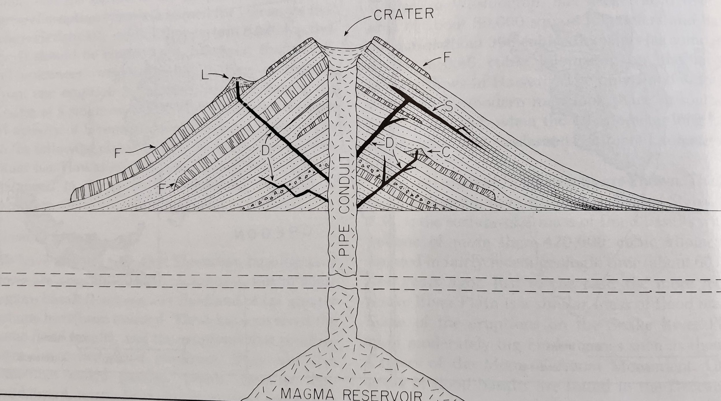
Craters: Bowl or funnel-shaped depressions.
Fault Scarps: The walls of volcanic calderas.
Pit Crater: Smaller craters formed by collapsed among the rift zones.
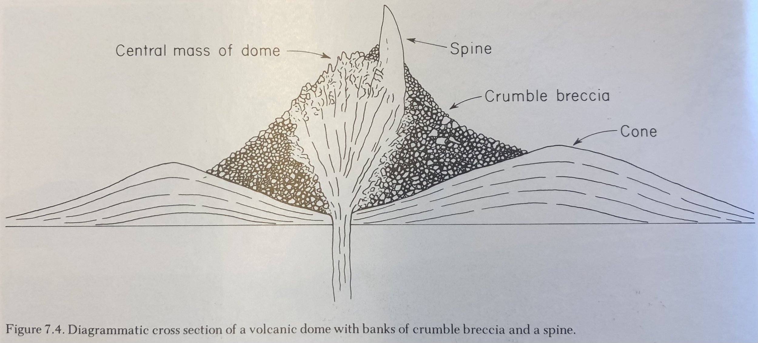
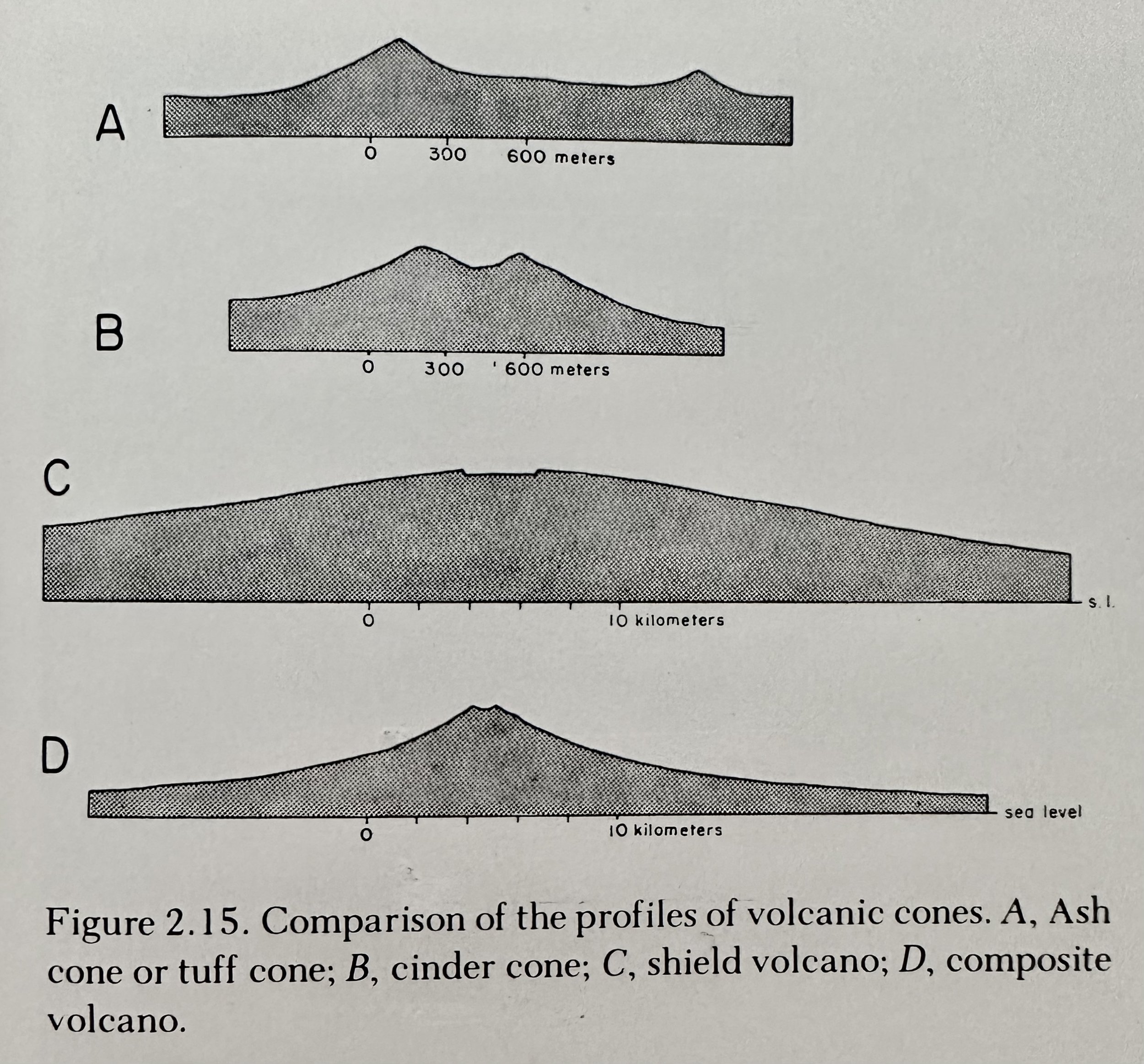
Volcanic Cones: Hills built by fragments falling around the vent that commonly take the shape of a cone with the small end cut off, and usually with a crater at the summit.
Spatter Cones: Volcanic cones formed of spatter and comprised of cow-dung shaped bombs.
Cinder Cones: Volcanic cones formed of cinder and comprised of spherical, ribbon, or spindle bombs.
Spatter Rampart: A heap of ejected material erupted along extensive long and narrow fissures.
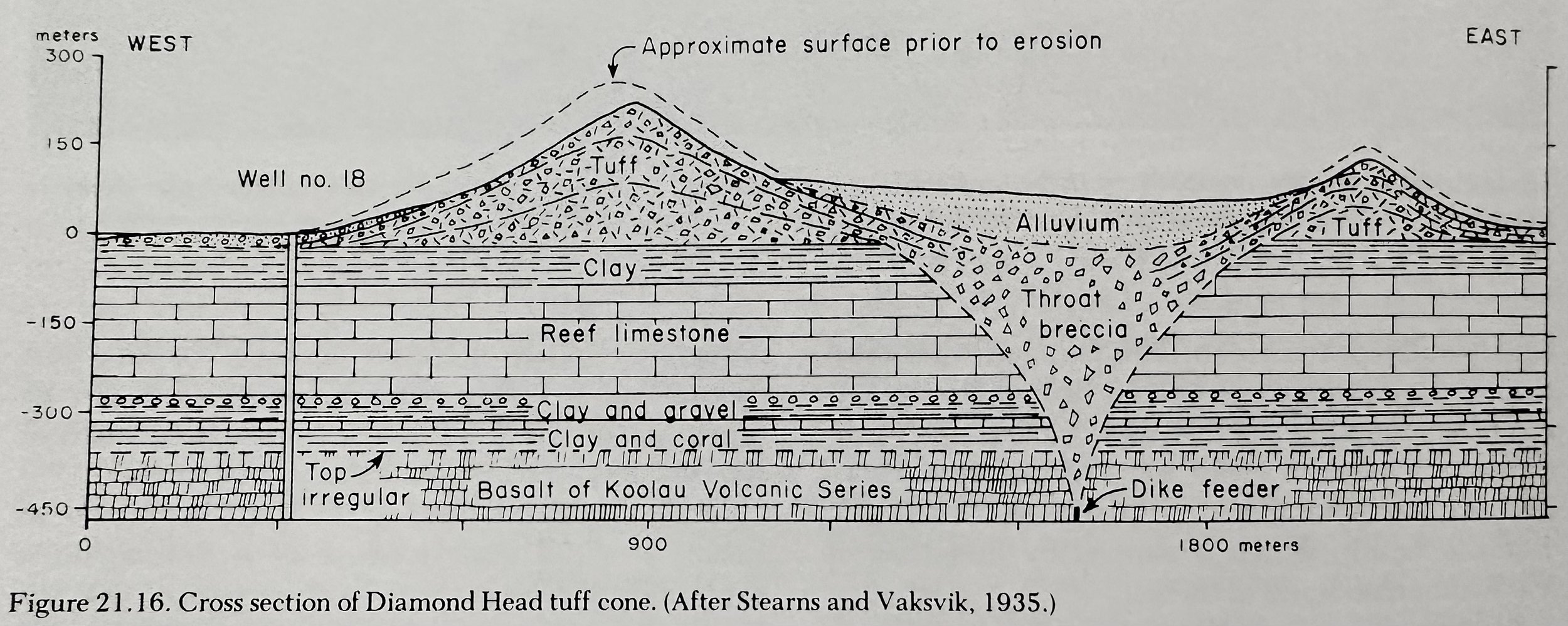
Tuff Cones: Volcanic cones formed as the result of hydromagmatic explosions in which magma meets water close to the ground surface and rapidly expanding steam blows much of the magma apart forming a spray of tiny fragments which harden in the air to particles of glassy ash.
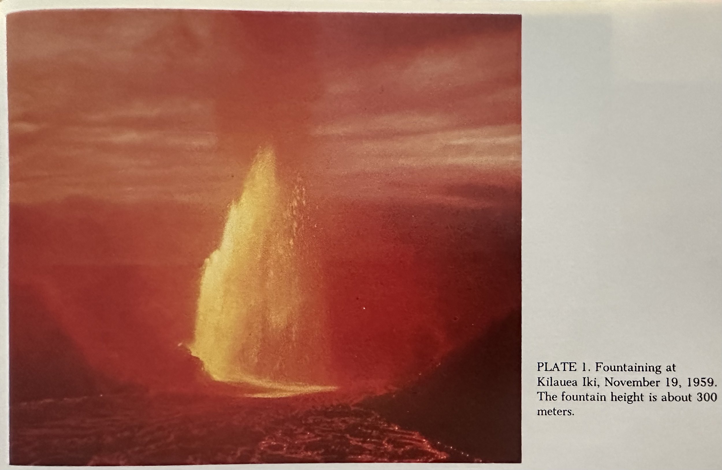
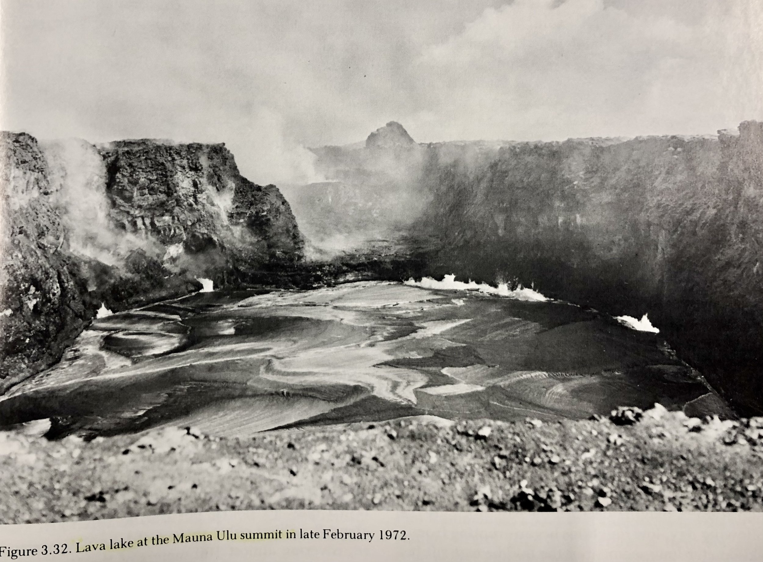
Eruptions: Release very fluid (low viscosity) lava containing only a relatively small amount of gas. Lava flows are thin, averaging ~4-5m in thickness, and only rarely reach as much as 15m. These far-spreading thin flows build broadly rounded, dome shaped mountains, known as shield volcanoes. Eruptions occur at both the caldera and along fissures extending across the summit and far down the flanks.
Shield Building: Kilauea and Loa have erupted an average of .1km3 of lava per year.
Phreatic Eruptions: Explosive eruptions caused by groundwater meeting with magma.
Littoral Explosions: Occur when lava flows enter the sea resulting in steam explosions. The out-rushing steam may carry with it a cloud of drops of liquid lava, which on contact with water or air chill into bits of black or brown glass. Sand-sized particles of this sort may be washed alongshore to accumulate at favorable localities to form black sand beaches.
Lava Characteristics
Lava Viscosity: Governed by chemical composition (the higher the silica content, the more viscous), its temperature, and the amount of gas it contains. Low viscosity fluid lava allows moderate amounts of gas to bubble out with little more than minor spattering; but in very viscous lava it is difficult for the gas to work its way upward and break through the surface of the liquid, and it accumulates until the pressure is sufficiently high to allow it to burst free.
Types
Pahoehoe: Smooth, billowy, or ropy surfaces. Most flows emerge from the vent as pahoehoe, changing to aa as they advance downslope.
Aa: Rough, spiny, rubbly lava. The more viscous the lava, the greater its tendency to change to aa.
Pillow Lavas: Formed when lava is chilled on contact with water under pressure.
At STP, most lava rocks begin to melt near 1100 degrees C and are fully fluid at 1200 degrees C.
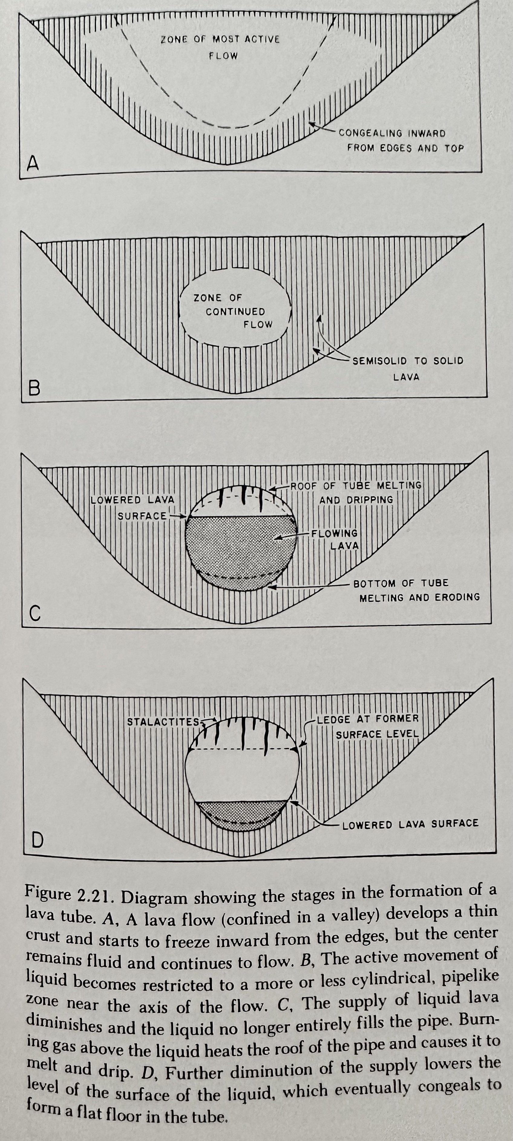
Lava Tubes: Cylindrically shaped subsurface flows of lava.
Shorelines: Nearly horizontal ridges on the sides of lava tubes formed by remnants of crust adhering to the walls.
Joints: Cracks in lava flows resulting from stress in the rock during cooling.
__________________________________________________________________________________
Hawaiian Minerals & Igneous Rocks
Rocks: Composites of mineral-like substances called mineraloids. Divided into three great classes:
Igneous: Rocks which have solidified from a once-molten condition.
Igneous Rock Types
Obsidian (Volcanic Glass): A mineraloid; once molten rock that solidified so quickly that minerals did not have time to form in it.
Granite: Comprised of Feldspar and Quartz.
Basalt: Comprised largely of anorthite- a rich plagioclase feldspar and pyroxene.
Scoria: Vesicle laden rock.
Vesicles: Bubble holes in rock highlighting gas coming out of solution.
Igneous Rock Formation
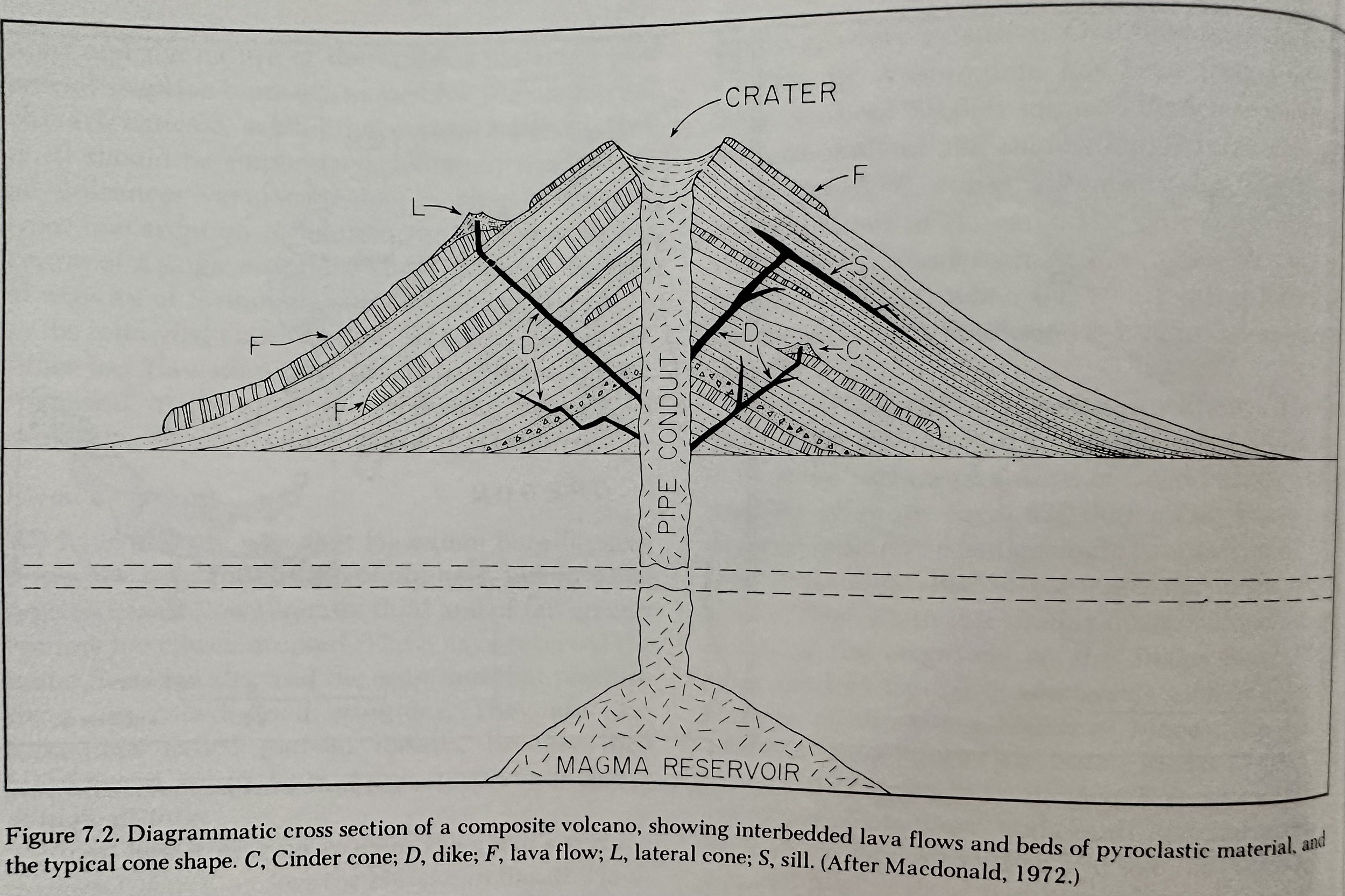
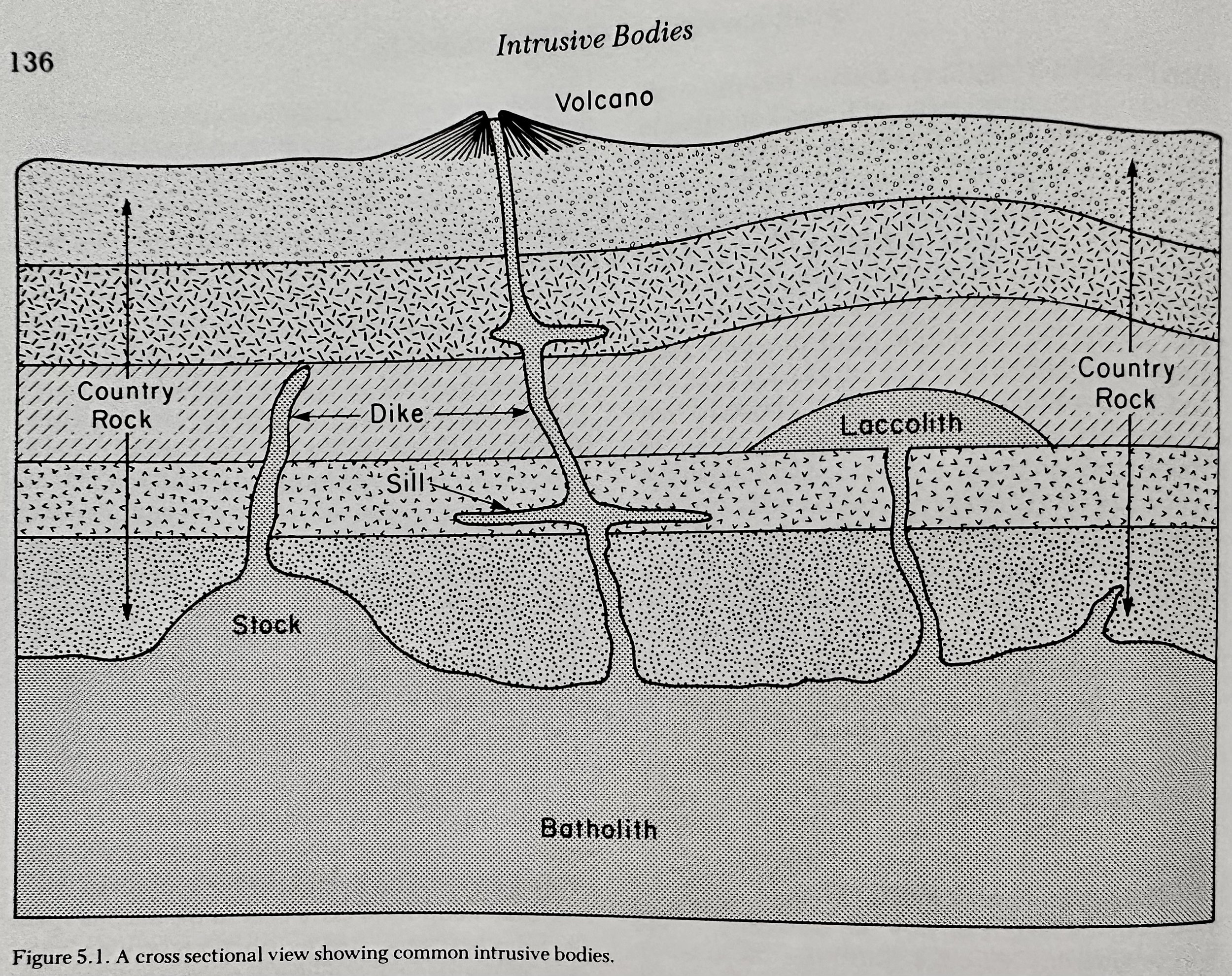
Pluton (intrusion): Magma that hardens before reaching the surface.
Phenocrysts: Rocks with Large Crystals
Porphyritic: Rocks containing phenocrysts.
Sedimentary: Rocks formed by the transportation and deposition of rock material by water, wind, ice, and gravity.
Metamorphic: Rocks which have been changed from their original conditions (metamorphosed) to bring them into equilibrium with a new physical or chemical environment- that is, to adjust them to a higher or lower temperature or pressure.
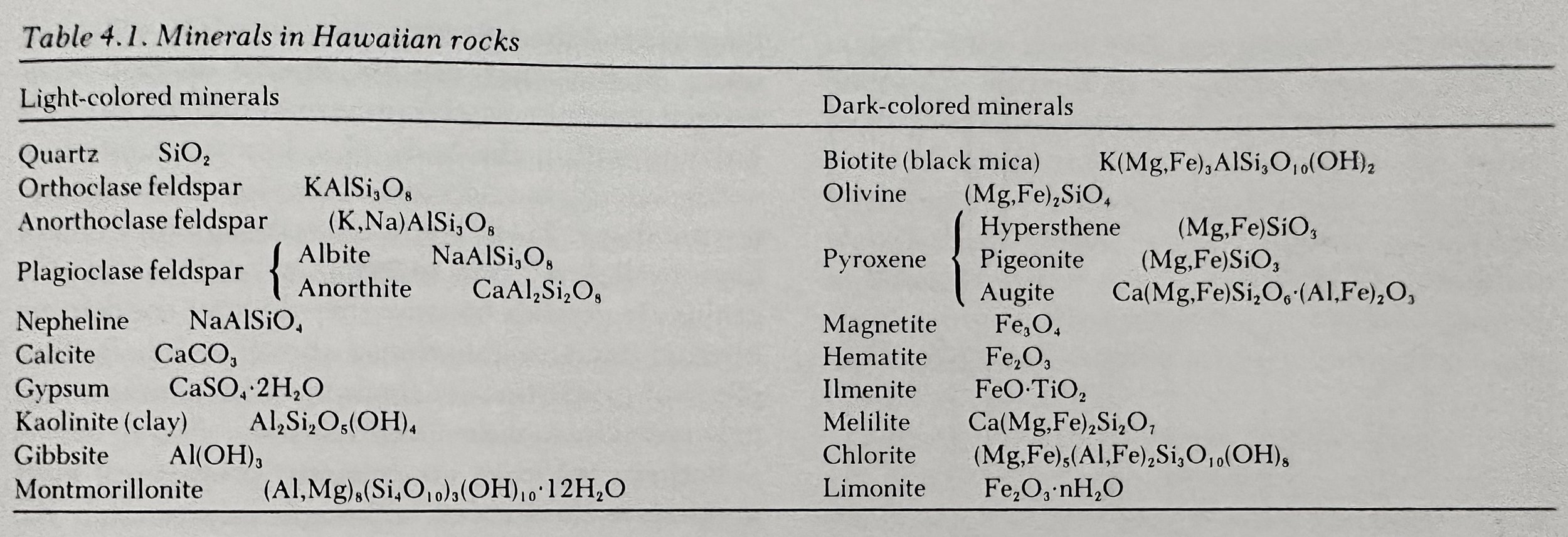
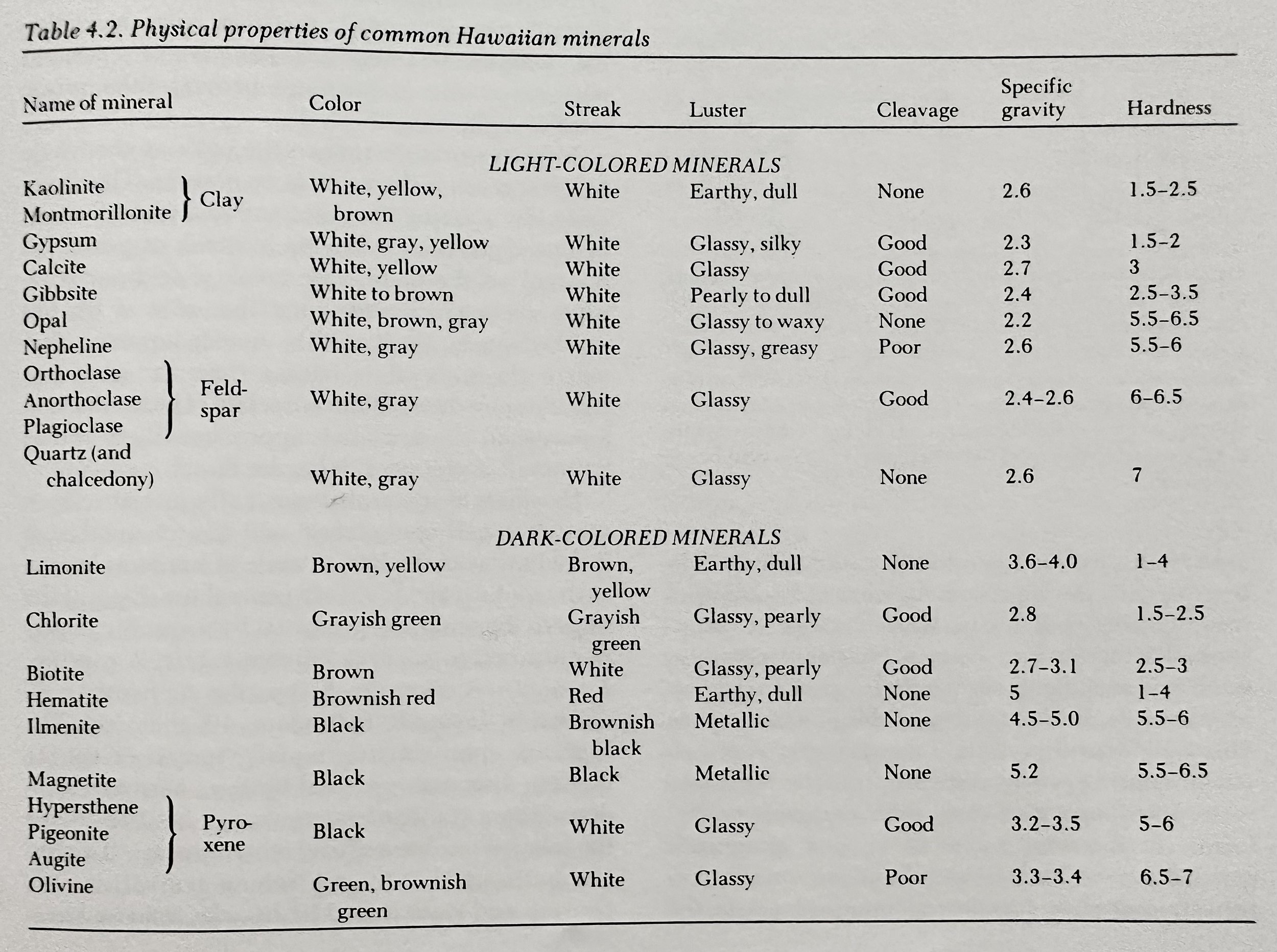
Mineral: A natural solid compound having a definite and invariable internal structure and a narrowly delimited chemical composition. Consist of combinations of atoms of various chemical elements arranged in certain patterns in relation to each other.
Mineral Properties: Color, Powder, Hardness, Cleavage, Luster, Density (specific gravity).
Hardness: Measured by scratch test and recorded in Mohs.
1: Talc, 2: Gypsum, 2.5: Fingernail, 3: Calcite, 3.5: US Penny, 4: Fluorite, 5: Apatite, ordinary knife blade, 5.5: Window Glass, 6: Feldspar, 7: Quartz, 8: Topaz, 9: Conundrum, 10: Diamond.
Cleavage: Splitting across smooth plane surfaces.
Luster: Appearance in reflected light.
Mafic (Magnesian) Minerals: Dark minerals containing Mg, Fe, or both.
Calcite: The most abundant mineral of Hawaiian limestones.
Feldspar: The most abundant mineral in Hawaiian rock.
Plagioclase Feldspars: Mixture of albite and anorthite; large white crystals in Hawaiian lavas.
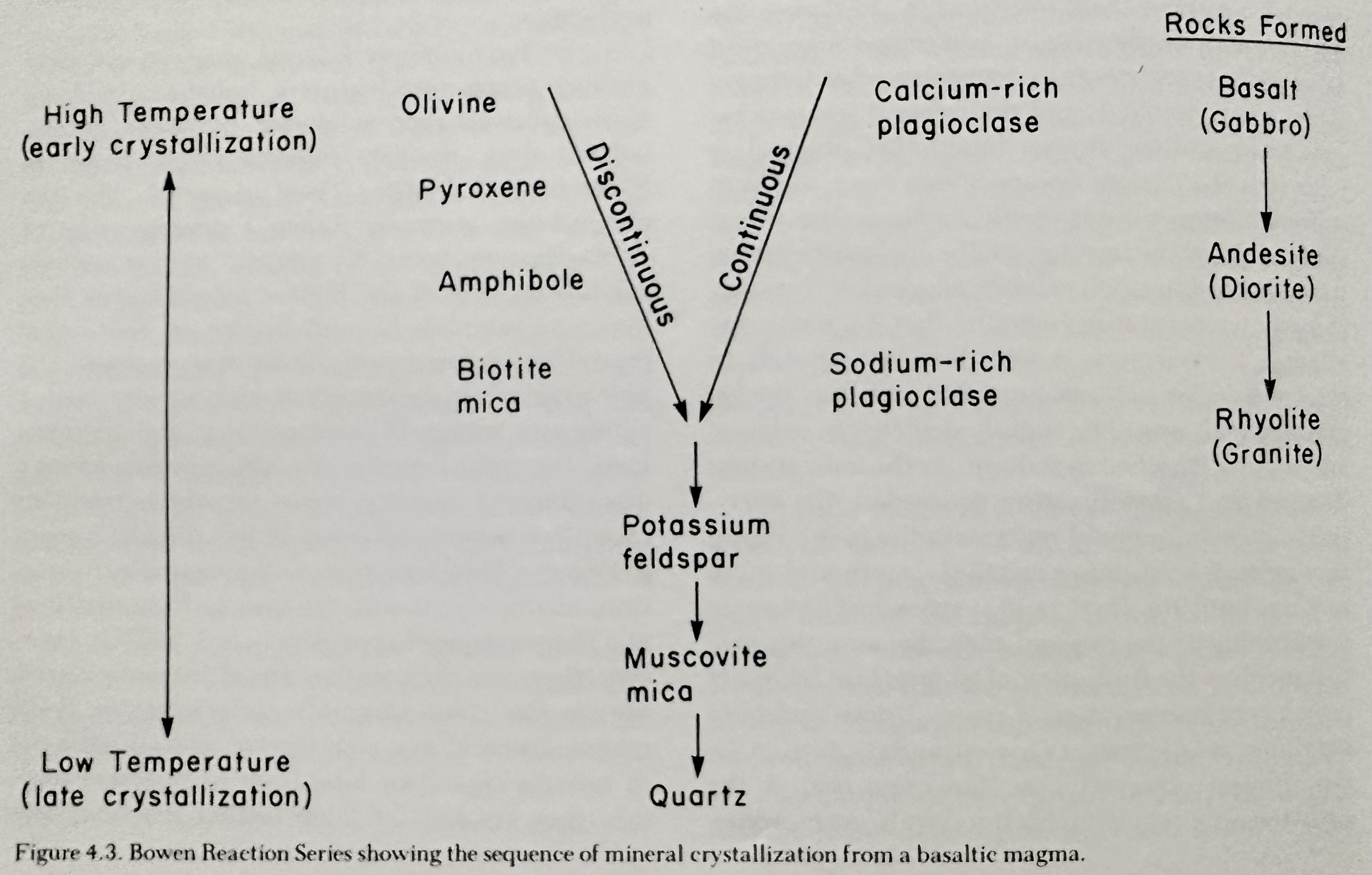
Magmatic Differentiation: The chemical process of change, as applied to magmas. As a high temperature magma of basaltic composition cool, minerals will crystallize along two paths, the continuous plagioclase feldspar series and the discontinuous mafic series.
Discontinuous Reaction Series: Describes the crystallization of mafic minerals in which reactions take place between minerals to definite compositions at fixed temperatures. Olivine forms first at the highest temperature to pyroxene, amphibole, and biotite at the lowest temperature.
Continuous Reaction Series: Describes the crystallization of plagioclase minerals, which occurs over a continuous range of compositions and temperatures. Ca-rich (anorthite) plagioclase forms at the highest temperature, and Na -rich (albite) plagioclase forms at the lowest temperatures.
The first to crystallize, are the least stable.
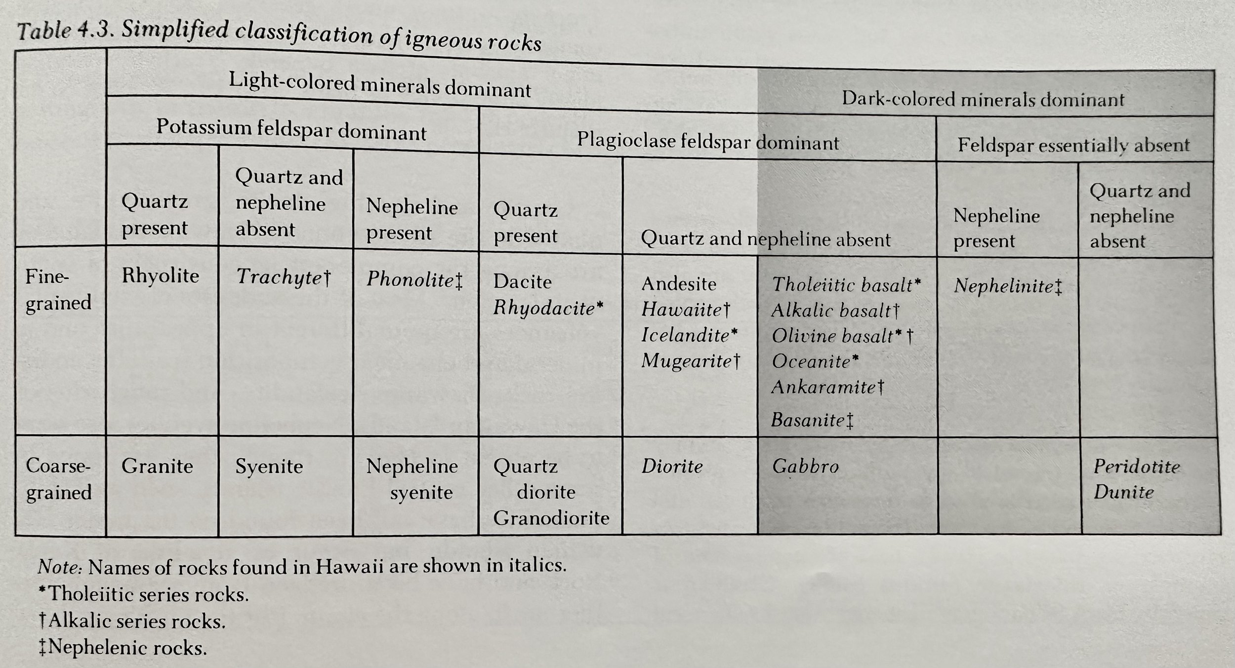
Hawaiian rock types can be arranged in three general series (or suites), the tholeiitic, the alkalic, and the nephelenic.
Xenolith (Inclusion): Fragments of older solid rock enclosed in a magma, and eventually left frozen into the solidified igneous rock.
__________________________________________________________________________________
Intrusive Bodies
Intrusive (Intrusive bodies): Consolidation of magma within the crust of the Earth at a depth where gases are not released from solution due the prevailing high pressure.
Sills: Sheetlike intrusive bodies that lie parallel to the stratification in bedded rocks.
Laccoliths: Lenticular bodies that have been intruded parallel to the bedding in stratified rocks and have made room for themselves by sharply arching up the overlying beds.
Batholith: The largest intrusive bodies.
Stocks: Intrusions less than 100km2 in area.
Bosses: Circular stocks.
Volcanic Necks (‘plugs’): The congealed fillings of ~cylindrical volcanic conduits.
Dikes: Fissure conduits through which magma rises towards the surface; channels through which magma from depth erupts at the surface.
Dike Swarms: Zone of abundant dikes.
__________________________________________________________________________________
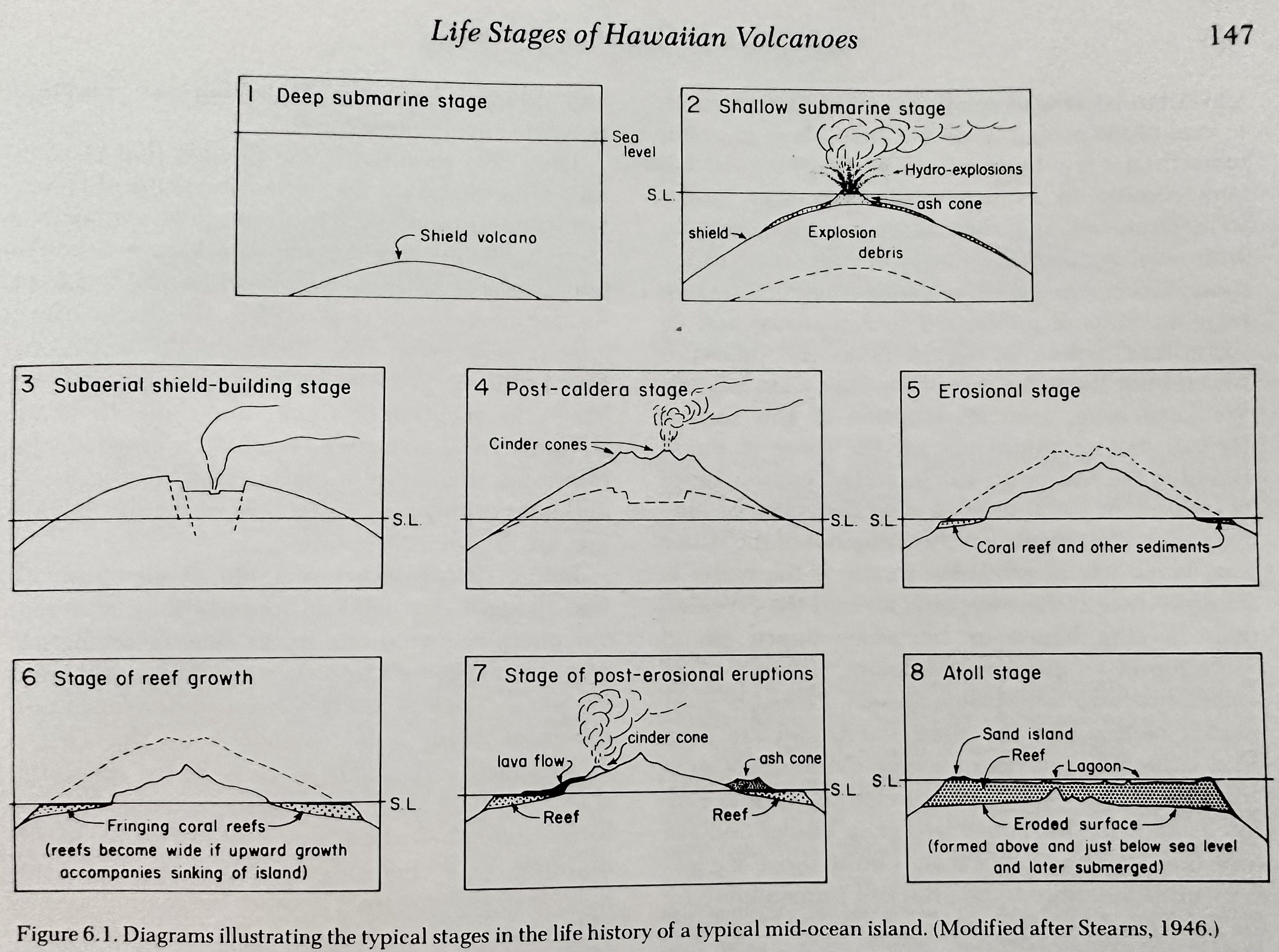
Life Stages of Hawaiian Volcanoes
Lifecycle: Volcanoes change as they grow older, becoming more explosive toward the end of their life spans. The explosiveness of an eruption depends largely on the fluidity, or viscosity, of the lavas, and their gas content.
Principal Period: Builds the main volcanic mountain; lasts many tens of thousands of years or more; predominantly erupting very fluid tholeiitic basalts.
Deep/Submarine Shield Building: Begins on the ocean floor, where the weight of 5+km of ocean water above restrains any tendency to explosive release of gas. In deep water the shield is built by repeated outpourings of dense lava. But as the mound builds close to the surface of the ocean the restraining pressure of the water decreases to the point where explosion is possible.
At great depths, the weight of the overlying water largely prevents explosions, and the bases of the mountains probably consist wholly of pillow lavas.
Hot lava encountering water may, under some circumstances, form large volumes of steam, with resulting violent and spectacular steam explosions. Steam explosions in shallow water throw up huge amounts of pulverized rock material and an “atomized” spray of liquid lava.
Subaerial Shield-Building: Volcanic shield building due to innumerable eruptions.
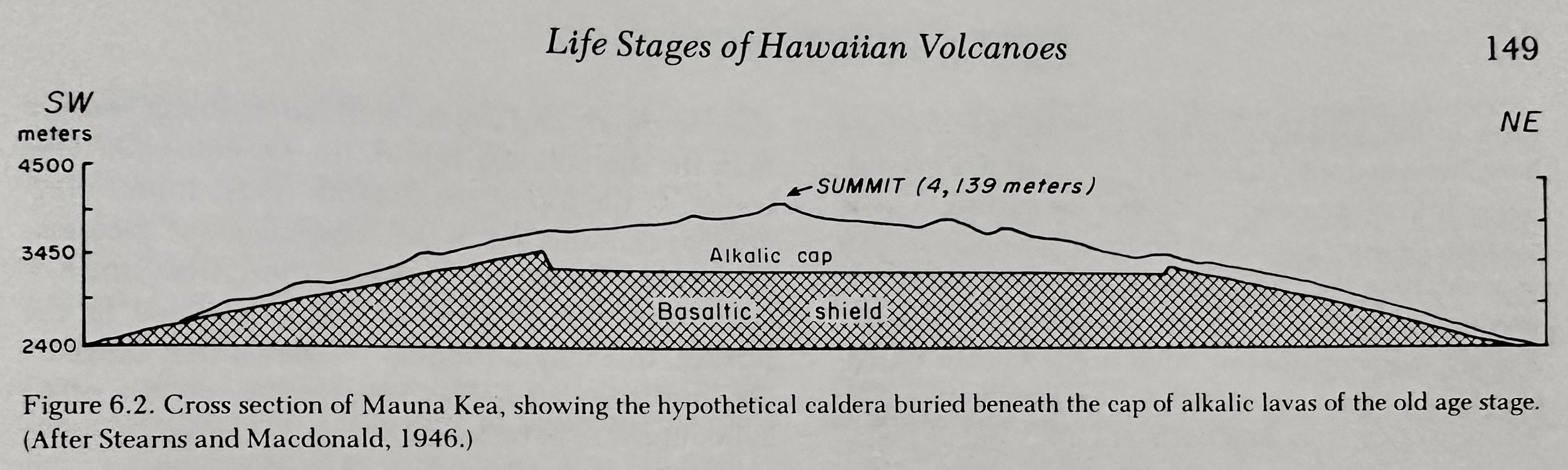
Old Age Period
Cap Building: A decrease in temperatures of the magma beneath the volcano induces a change in lava composition from relatively low tholeiitic basalt with little dissolved gas to a relative high viscosity alkaliitic basalt with more dissolved gases. These more explosive eruptions add materials atop the shield, completely hiding the caldera and building a cap. The cap is commonly steeper and less extensive than the shield and the new rocks are all within the alkalic series: ankaramite, hawaiite, mugearite, and trachyte that appear from the alkalic basalt magma largely due to crystallization in the magma chamber beneath the volcano.
Rejuvenated Period: A time of renewed volcanic activity (tens of thousands of years long) that follows a long period of volcanic dormancy and erosion.
In general, there is no evidence in Hawaii that magma of the rejuvenated period eruptions was guided to the surface by faults.
__________________________________________________________________________________
Types of Volcanic Eruptions and Associated Hazards
Volcanoes are commonly classified on the violence of the explosion.
Flood Eruptions (Flood/Plateau Basalts): Predominantly high-volume fluid basalt flows that flood the Earth’s surface through fissures scattered over a wide area (as opposed to being concentrated in narrow rift zones). Successive eruptions leave a broad, nearly level surface with flows some 15-30m thick.
Examples: Columbia Plateau, Snake River Plain, Deccan region of NW India.
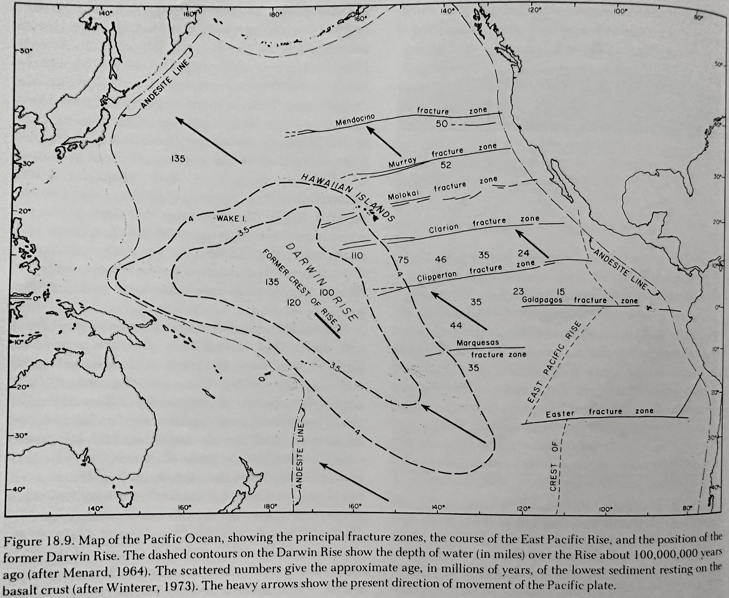
Much of the crust of the present sea floor consists of basaltic lava flows erupted from a series of enormous fissures which can be traced some 50K km over the ocean bottom.
Hawaiian Eruptions: Characterized by the extrusion of fluid basaltic lavas.
Strombolian Eruptions: Eruptions characterized by less fluid lavas, typically erupted with considerable explosive activity. Single Strombolian eruptions build cinder cones accompanied by lava flows while repeated Strombolian eruptions from the same vent may build composite volcanoes composed of interbedded tephra and lava flows.
Vulcanian Eruptions: Eruptions characterized by more viscous lavas, forming small stubby flows, and a great preponderance of tephra. Often the most conspicuous feature of a Vulcanian eruption is the tremendous dark cloud of ash-laden gas that rises several km into the air.
Pelean Eruptions: Eruptions characterized by very viscous lava which erupt explosively, sometimes giving rise to glowing avalanches.
Nuee Ardente: An avalanche of heavily laden fragmented material that flows down a mountainside.
Plinian Eruptions: The most powerful of known eruptions; cataclysmic in power and very destructive. Much of the pumice is blown apart by expanding gas to form tiny fragments of ash that flow as ‘ash flows.’
Named for Pliny the Elder; a roman naturalist killed while investigating the eruption of Vesuvius in 79.
Eruptions are characterized by the following general sequence of events: 1) formation of a large bulge on the volcano, 2) collapse of the bulge, which produces massive land sliding and debris avalanches, 3) the resultant unloading of magma, which causes it to explode violently.
Volcanic Hazards: Lava flows, falling tephra, nuee ardente, base surges, mudflows, and toxic volcanic gases.
H2O vapor is by far the most abundant gas given off by volcanoes.
Predicting Eruptions: The most useful method is the monitoring of seismic activity and ground tilting.
Harmonic (or Volcanic) Tremor: A continuous ground vibration with a frequency of a few cycles per second.
Deflation: Subsidence of the summit region of a volcano post eruption causing the upper slopes to tilt inwards.
Control of Lava Flows: Limited control of smaller flows appears possible through diversion & damming, bombing, and water spraying.
__________________________________________________________________________________
Rock Weathering & Soils
Weathering: Breakdown of rocks at and near the surface of the Earth into new materials when attacked by air and water and other surficial agents.
Mechanical Weathering (Physical Disintegration): Breakdown of rock into smaller and smaller pieces without change in its chemical or mineral composition.
Frost Action: Expansion within rock grain boundaries due to the expansion of water as it solidifies, eventually causing rock to break apart.
Heating: Expansion of rock mineral grains due to the heat. Some grains expand more than others, setting up stresses along the grain boundaries, eventually causing them to break apart.
Chemical Weathering: Alteration in chemical composition and the formation of new minerals. Principal processes include Oxidation, Hydration, Hydrolysis, Carbonation, Cation Exchange, and Solution.
Carbonic Acid: Formed by H2O in the soil and CO2 in the soil and atmosphere, which dissolves CaCO3 in limestones and the Ca- bearing minerals in lavas.
Humic Acids: Results from the decay of vegetation; dissolves rock forming minerals.
In temperate zones the principal residual products of chemical weathering are clay minerals and hydrated Fe-oxides.
Soils
Soil Horizons
A: All of the most soluble products and some of the less soluble ones have been leached out and carried downward by percolating water; usually an abundant admixture of humus.
B: Chemical weathering is more advanced, and commonly only the most resistant of the original rock-forming minerals remain, where Fe-O2 and clay are re-deposited.
C: Lowest zone, Subsoil grading into underlying rocks.
Properties: Soil Depth, Moisture, Temperature, Texture, Structure, Cation Exchange capacity, base saturation, clay mineralogy, organic matter content, presence of oxides of Fe, Al, and salts.
Residual Soils: Soils formed by the breakdown of the rocks beneath them.
Montmorillonite: A soil type that with sufficient water, may expand up to 15x its own volume.
__________________________________________________________________________________
Mass Wasting
No sooner does a land area appear than various forces set to work to destroy it.
Erosion: The processes of land destruction including weathering which softens rocks and breaks them down into smaller fragments, rainwater and streams that run over the surface of the ground and wash loose material downslope, moving it ever closer to the ocean; gravity which moves soil and rock fragments downhill; wind which blows fine material away; ice that scrapes off the surface material and carries it away; the ocean waves that gnaw at the edges of the land, and ocean currents that sweep away the broken debris.
In Hawaii, erosion is dominated by streams, wave, and mass wasting.
Mass Wasting: The downslope movement of rock and soil debris under the influence of gravity. Includes rockfalls, landslides, mudflows, soil avalanches, and soil creep. Gravity is the driving force.
Colluvium: Accumulations of fragmental material that moves down the sides of valleys as a result of all the processes of mass wasting.
Soil Creep: General term for en masse downhill movement of the superficial parts of the soil.
Soil Avalanche: Soil Cover on a steep slope simply pulls loose from the underlying bedrock and slides downwards.
Talus: Piles of angular rock fragments at the foot of a cliff, formed by fragments tumbling down the slope.
Angle of Repose: The angle that the surface of the talus slop assumes. It is the steepest angle at which the fragments will stand without sliding or rolling downhill.
Landslides: Movement of rock downhill due to over-steepened slopes, weak soil or rock material, triggering events which further increase surface loading or decreases the soil and rock strength.
Debris Slide: A type of landslide in which unconsolidated or poorly consolidated material, such as colluvium, sand, clay, or deeply weathered rock, separates from the bedrock by surface shearing and moves downhill.
Rock Slide: A type of landslide in which solid hard rock separates from the bedrock by surface shearing and moves downhill.
__________________________________________________________________________________
The Hydrologic Cycle and Stream Erosion
Stream Action, in combination with weather, mass wasting, and wave action, is the predominant sculptor of Hawaiian landscapes.
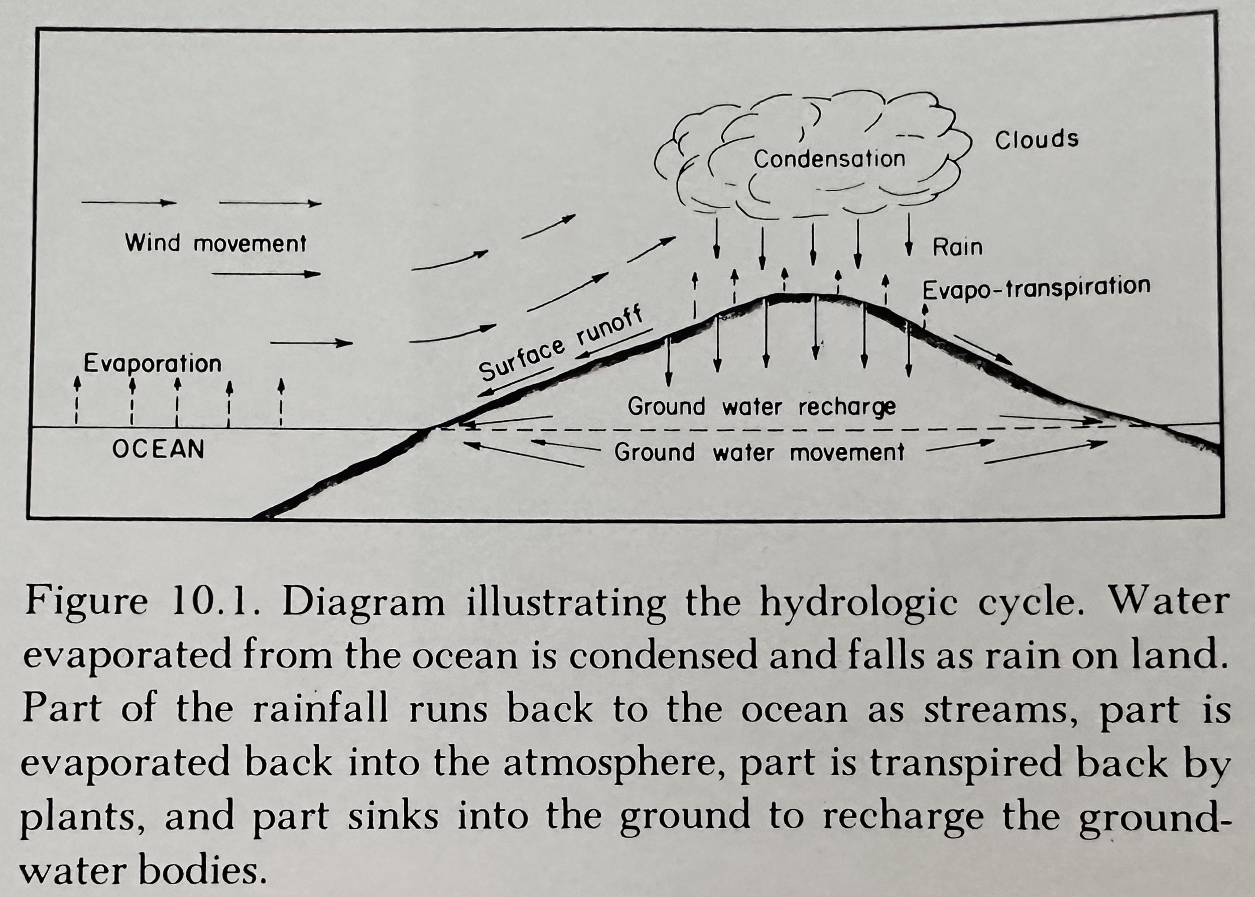
Hydrologic Cycle: A simplified description of the way in which water is transported from place to place; water is driven through the hydrologic cycle by heat energy from the sun. It first is evaporated from the surface of the surrounding warm ocean and transported over land by wind, where it condenses to form clouds and eventually falls as rain. Rain that falls to the ground surface may either infiltrate or into the subsurface, or runoff along the surface and eventually collect in streams and then flow back into the ocean. Some of the water that soaks into the ground may return directly to the atmosphere by evaporation from the soil. Another part may be taken in by plant roots and then returned to the atmosphere through transpiration by the leaves.
Hydrologic Budget: A simple way of representing how precipitation which falls on the ground surface is distributed: P = RO + I + ET (P: Precipitation, RO: Surface runoff, I: Infiltration, ET: Evapotranspiration).
Rainfall results principally from the orographic ascent over the volcanic mountains of the NE trade winds which prevail about 90% of the time in the summer months. Rainfall in the Hawaiian Islands: ~190cm per year.
Principals of Stream Erosion and Deposition
Stream Load: The weight or volume of material being moved in a stream. The load the stream can transport depends directly on the volume of the stream, but varies as the square of any change in velocity.
Stream Capacity: Maximum load of the stream.
Competence: Largest particle size that can be moved in a stream.
Erosion Velocity: The critical stream velocity required to erode particles of a given size. Two factors control erosion velocity. For particles of sand size and larger, erosion velocity is a direct function of particle size. However, silt and clay-size particles are strongly held in place by cohesion, and thus the high velocities are required to erode these tiny particles.
Base Level: The level that limits the depth to which a stream can cut.
Rejuvenated Stream: A restoral of erosive power to a stream due to a change in climate with a resulting increase in volume of water, or by lowering of base level.
Stream Lifecycle
1. Surficial Rocks become partially sealed by chemical weathering or a by a cover of fine volcanic ash that enables sustained or prolonged surface runoff.
2. Stream cut V- shaped notches into the land surface.
3. In the youthful stage of stream erosion, downcutting is greatly predominant over lateral cutting, and the stream tends to cut a vertical sided notch.
4. As the streams approach grade, lateral cutting becomes more and more important, and eventually a broad, gently sloping valley floor is produced.
5. Even as the old age is approached, the side slopes of the valley remain steep. If in any way the slope is reduced to a lower angle, slope retreat simply ceases until lateral widening of the valley floor has pushed back the base of the slope sufficiently to re-establish the critical steepness.
6. A Peneplain is produced; a broad nearly plain surface with very low relief; the ultimate end of the process of stream erosion.
__________________________________________________________________________________
Groundwater
Groundwater: Water occupying the voids in rocks below the level of the soil.
Recharge: The addition of water to groundwater.
Unsaturated Zone (Zone of Aeration): The subsurface zone that is not completely saturated with water and remains partly filled with air.
Vadose Water: Water within the zone of aeration.
Darcy’s Law: The mathematical expression for the flow of liquids through subsurface materials.
Q = K A (h/l).
Q: GW discharge, K: Hydraulic conductivity (similar to permeability), A: Area through the flow is occurring, h: Difference in elevation of gw levels, L: length of the flow path.
GW flow is directly proportional to rock permeability and the difference in gw elevation (head).
Hydrologic properties that control gw occurrence and movement are porosity and permeability.
Porosity: The percent of pore space in a given rock or soil volume; a measure of the water storage capacity of any subsurface material.
Permeability: A measure of the ease of transmission of a fluid through rock or soil materials; defines how rapidly water can flow through subsurface materials.
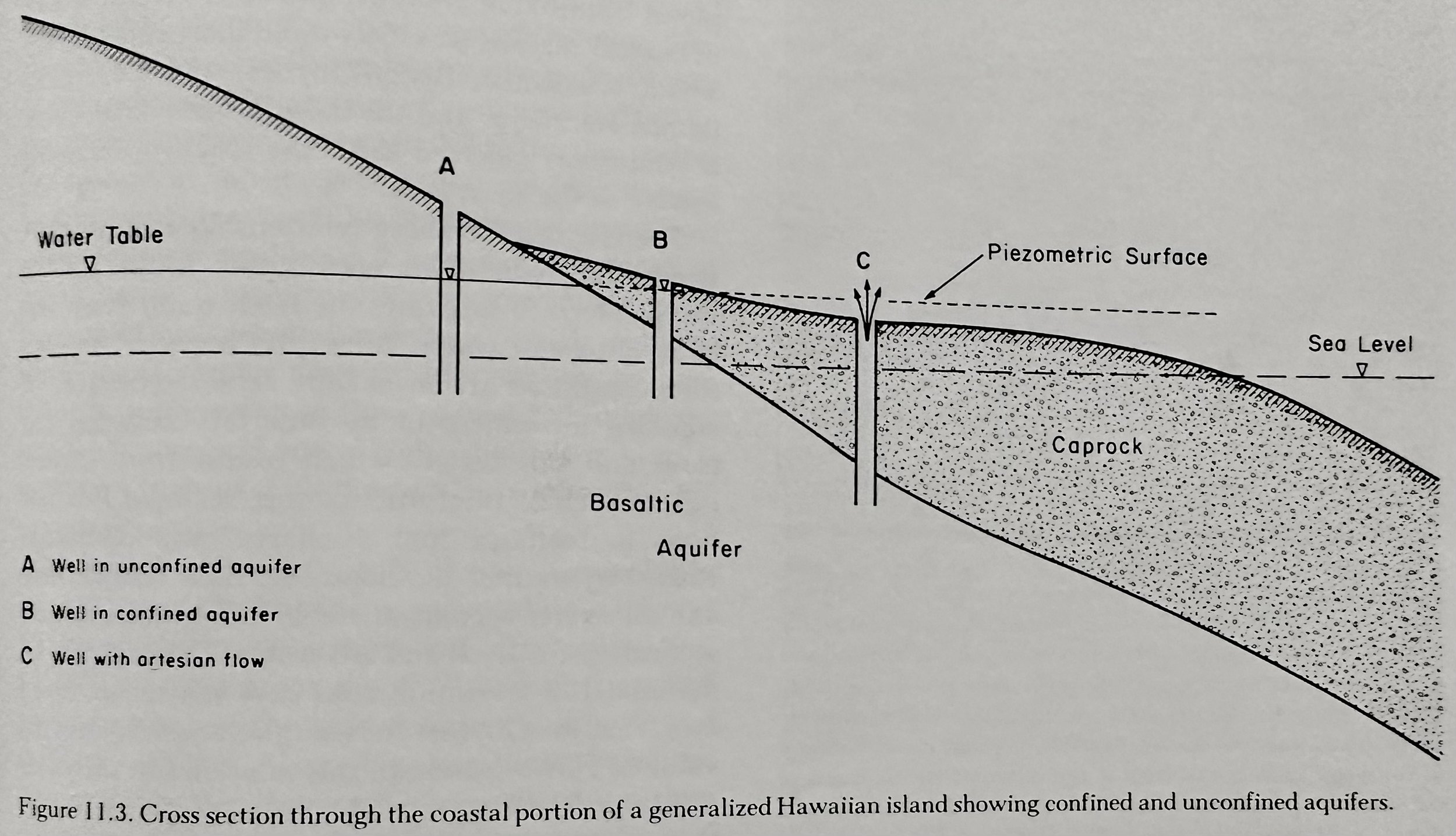
Aquifers: Geologic formations with sufficiently high porosity and permeability to readily yield water to wells.
Unconfined Aquifer: Aquifers whose upper surface is a water table which is free to fluctuate in response to changes in aquifer storage.
Confined Aquifer: Aquifers unbounded on the top by a free water surface (water table), but rather is confined below an impermeable, or at least a low-permeability layer.
Piezometric (Artesian Head): The height to which water rises in a drilled borehole.
Artesian Flow: Water that flows freely up to the ground surface.
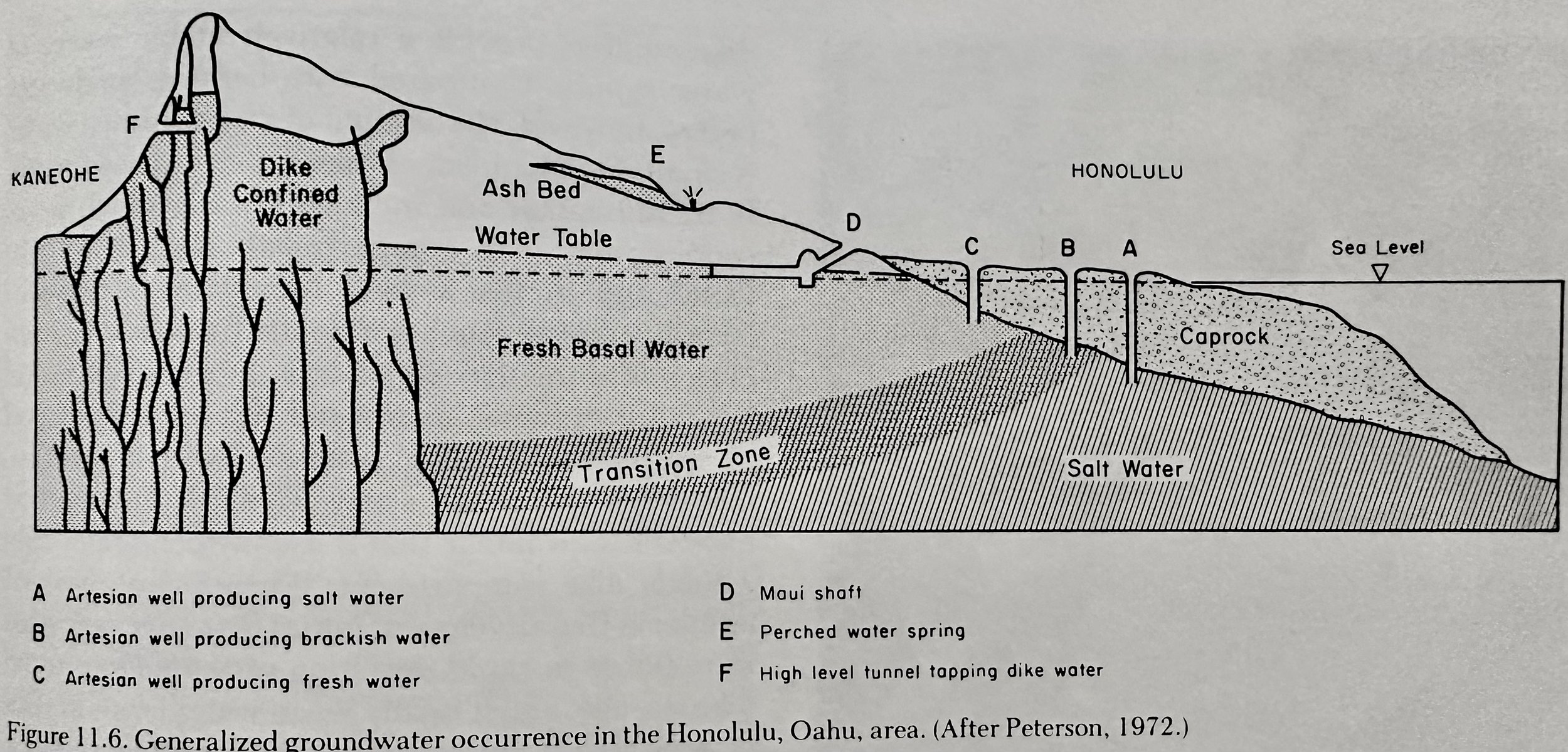
Basal Groundwater: Freshwater that rises to the surface of saltwater due to its lower density.
Fresh water basal springs are often noticed by swimmers as zones of unusually cold water such as the great Pearl Harbor springs, with a discharge of ~230M liters per day.
Perched Groundwater: Water held between an unsaturated zone and the basal water table.
GW Problems: Depletion of gw supplies and deterioration of their quality.
Sustainable Yield: The amount of gw which can be removed from an aquifer over a period of many years without having serious deleterious effects on the aquifer.
__________________________________________________________________________________
Work of the Wind
Eolian: Commonly used to describe the activity/deposits of the wind (from Eolus, Greek God of the Winds).
Dust: Consists of mineral grains <.06mm in diameter.
Loess: Deposits of dust.
Sand: Consists of grains >.06mm in diameter.
Deflation: Wind erosion by abrasion of rock surfaces by moving sand.
Pedestal Rock: Sand abrasion which cuts away the base of a rock outcrop or a boulder, leaving a “wine glass rock.”
__________________________________________________________________________________
Work of Ice
Ablation: The combination of melting and evaporation in the zone of wastage.
Glacial Features
Cirque: A steep-walled amphitheater, usually formed at the head of a glacial valley.
Arete: Two cirques cutting into a ridge from opposite sides that modify it into a jagged knife-edged wall.
Horn: 3+ cirques cutting into a mountain that may produce a very steep sided pyramidal or tooth-shaped peak (Matterhorn).
Long Island is part of the terminal moraine left by glacial retreat during the last ice age.
During the last Ice Age, in N.A. the ice spread out from three general centers, one in the Canadian Rockies, one in Central Canada, and one in the vicinity of Labrador.
__________________________________________________________________________________
Work of the Ocean
Currents: Water flowing from one part of the ocean to another; currents are caused by tides, breaking waves, wind, the rotation of the earth, and water density.
Water Density: Differences in density are in turn caused by differences in temperature, in salinity, or in the amount of sediment suspended in the water. Cold water is heavier than warm, salt water is heavier than fresh, and sediment-loaded water is heavier than clear water. Heavier water always tends to move below lighter water, and in doing so it creates a density current. Currents of dense sediment-laden water, called turbidity currents, are believed to move downslope into the deep ocean fast enough to erode submarine canyons- and at times to break submarine telephone cables.
Tides: The rise and crest of water due to the combined gravitational pull of the sun and moon. The two sets of tides are not synchronous because the sun tides have a 24h period and the moon tides have a 24h, 50m period.
Spring Tides: Maximal range tides when the sun and moon reinforce each other.
Neap Tides: Minimal range tides that occur every two weeks at first and third quarter moons, when the moon and sun are at right angles to each other.
Flood Tide: When tide rises, water flows in towards the shore.
Ebb Tide: When tide crests and starts to fall, flowing offshore.
Beach Features
Backwash: The backwards movement of water down the beach.
Progradation: Seasonal cycles of beach widening in the summer months.
Retrogradation: Seasonal cycles of being shrinking in the winter months.
Rip Current (Undertow): Seaward escape of water that backs up between the breaker zone and the beach.
Spit: Buildup of sand drifted alongshore which extends out partly across the entrance of a bay.
Swash: The forward movement of water up the beach.
Marine Erosion and Deposition
Wave Erosion: Occurs via abrasion and hydraulic action, which smooth and round dislodged rocks.
Hydraulic Action: The pressure exerted by the water both directly and through trapped/compressed air.
Rate: Hawaiian island shorelines are being cut back at ~5cm/yr (CK Wentworth Estimates).
Changes in Sea Level
Eustatic Shorelines: Shorelines developed by changes in sea level while the land remains stationary.
A very prominent bench lies in ~90-120m below sea level at many places around the Hawaiian Islands. There is little doubt that it is a terrace cut by waves when sea level was about 90m lower than now.
Shorelines between 0 and 75m, and 18 and 90m below present sea level, are eustatic.
At maximum stage of glaciation sea levels should have been lowered some 75-120m.
Tectonic Shorelines: Shorelines that developed as a result of tectonic rise/subsidence.
Shorelines above +75m and below -90m almost surely are tectonic.
Oahu: ~360-540m of depth; terrace or succession of terraces cut largely by wave action.
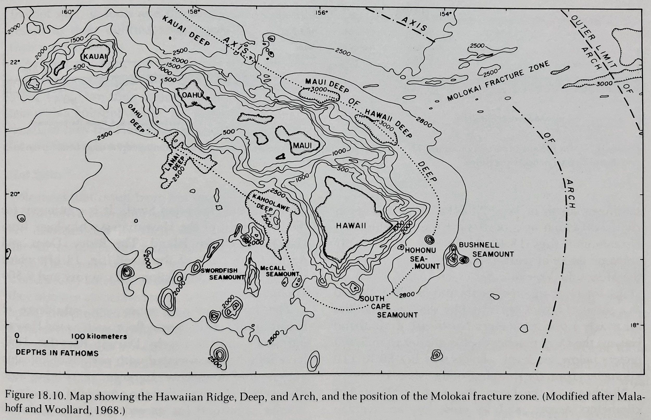
Hawaiian Islands: ~900-1100m surrounding all of the islands except the S. end of Hawaii island where it may have been buried by lavas of Mauna Loa, Kilauea, and Hualailai. Around the central islands it is several km wide, reaching a maximum width of 65km off the Western end of Oahu. It is narrower around Kauaui and Niihau, possibly because of the outward encroachment of a mass of sediment around these older islands. This bench has been named by Stearns the Waho Shelf. There appears to be not other reasonable explanation for it except wave erosion, and this, in turn, implies a sinking of the islands by 1000-1100m since the bench was cut.
The Darwin Rise, of which the Hawaiian Islands lay well out on its E. flank, probably sank >1200m as a result of the collapse of the rise.
The tremendous pile of volcanic rocks erupted onto the ocean floor during formation of the islands produced a huge excess of mass and caused the Hawaiian crust to be out of isostatic balance. In order to regain isostatic equilibrium, the Hawaiian Islands rapidly subsided many hundreds of meters, which has caused a slight crustal thickening beneath the Hawaiian ridge.
Mid-Pacific Mountains. At least 20 separate large seamounts can be counted along this range and most of them have nearly flat tops (guyots). The Presence of reef-forming corals and other shallow-water fossils, together with rounded cobbles and pebbles of volcanic rocks that now lie 1800m and more below sea level. Fossils dredged from the tops of the guyots are of late Cretaceous (~80ma).
Isostasy: The principal of flotational equilibrium as applied to the Earth’s crust.
Uplifts on the order of km have taken place as parts of the Pacific plate moved over hotspots.
Coral Reefs
Corals: Marine animals that extract dissolved CaCO3 from sea water and deposit it around themselves to form a limy supporting structure, or external “skeleton.” Reef coral can grow only in water <60m deep.
Fringing Reef: Reef that grows directly along shore, forming platforms that extend out from the shorelines.
Barrier Reef: Reef lying some distance away from the shore and separated from it by a belt of shallow water, called a lagoon.
Atoll: Roughly circular reefs with no land mass in the center, but only a broad lagoon.
__________________________________________________________________________________
Sedimentary Rocks
Strata: Layers of deposited sedimentary rocks; said to be stratified.
Sedimentary Rocks: Classified according to the way the material composing them was transported and deposited.
Lithification: Consolidation of loose material such as loose sand or soft mud into hard rock by deposition and cementing from from the weight of accumulating sediment above. The cementing material is usually silica (SiO2), calcite (CaCO3), Iron Oxide (FeO2), or clay.
Sorting: Separation of fragments of different sizes due to transportation by water or wind.
Beachrock (Calcareous Sandstone): Consolidation of calcareous (limy) sand composed of shells of single-celled animals and plants, especially foraminifera, washed ashore from coral reefs.
Constant wetting and drying of sand grains creates cementing in the short term.
Evaporites: Rocks resulting from evaporation, include NaCl (Rock Sat), gypsum (CaSO4-2H2O), limestone (CaCO3), and dolomite (CaMg(CO3)2).
CO2 + H2O = H2CO3 (Carbonic Acid).
Coal: Composed of the carbonized remains of plants, generally accumulated in swamps. The alteration of vegetable material into coal consists of the gradual elimination of other materials, particularly volatile ones, and the concentration of carbon.
Peat: A woody brown C-rich substance; the first stage in coal formation.
Lignite (Brown Coal): The second stage in coal formation.
True Coal: The final stage in coal formation.
__________________________________________________________________________________
Rock Deformation, Earthquakes, and Tsunamis
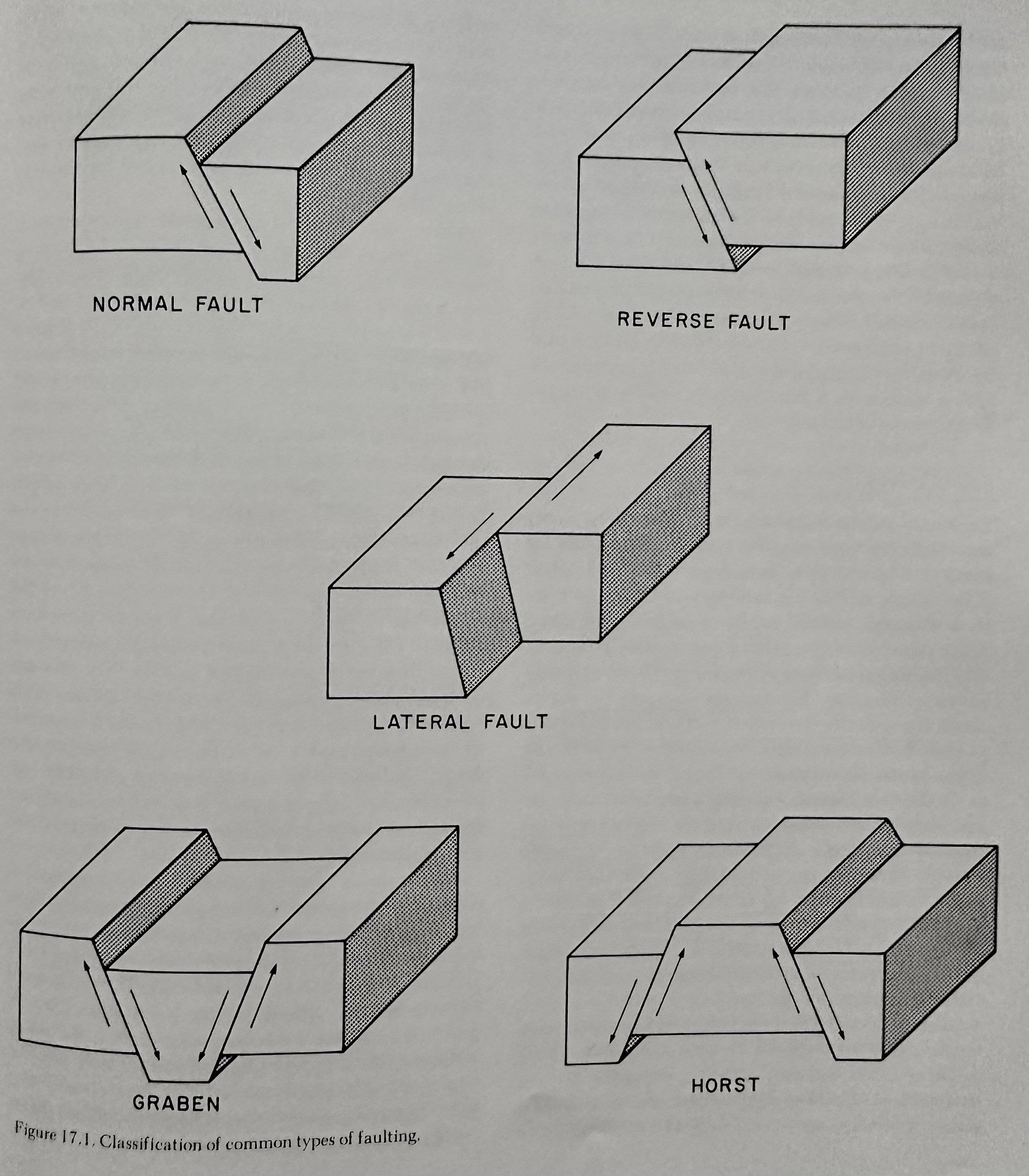
Rock Deformation: Changes in the shape or form of rocks in the Earth’s crust, may involve changes in volume, shape, and even rupture of rock masses.
Stress: The pressure, or force, acting on a unit surface area.
Strain: Deformation due to stress.
Compression Stress: Compression or squeezing of a rock mass.
Tensional Stress: Results in the lengthening of pulling apart of a rock mass
Shear Stress: Results in the shearing of a rock mass.
Elastic Deformation: Rebound of rock under stress to its original pre-stressed form.
Brittle Rocks: Rupture rather than flow, when stressed beyond the elastic limit. Ductile rocks undergo considerable plastic flow before finally rupturing.
Joints: Cracks along which no appreciable displacement has occurred.
Earthquakes
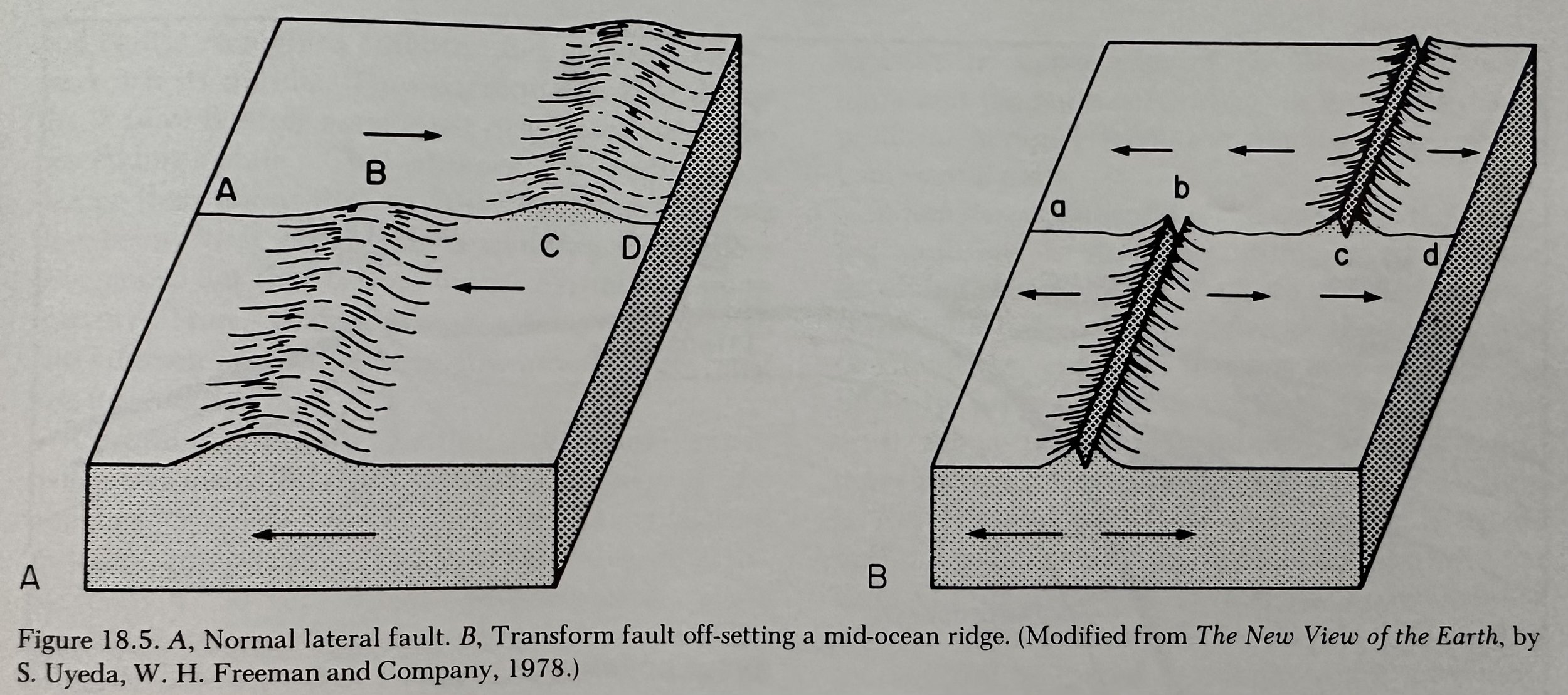
Tectonic Earthquakes: Earthquakes caused by movement along faults.
Volcanic Earthquakes: Earthquakes caused by the movement of hot viscous magma moving beneath the earth’s surface, it pushes its way through the surrounding rocks and fractures them.
P (Primary) Wave: The fastest of all eq waves; moves like a sound wave by alternatively pushing (compressing) and pulling (dilating). P-waves move through both solids and liquids.
S (Secondary or Shear) Wave: Move by a shearing motion at right angles to the direction of travel. Because liquid materials cannot support shear stresses, S-waves cannot move through liquid portions of the Earth such as the ocean or molten rock.
Magnitude: Measure of the actual amount of energy released.
Mercalli Scale: The EQ intensity scale, with a range of 1-12.
Richter Scale: The Logarithmic magnitude scale invented by Richter. The magnitude is determined by measuring the maximum eq wave amplitude recorded on a standard seismograph, considering the distance from the epicenter from the seismograph.
Tsunami (long wave in a harbor- Japanese): A series of elastic waves in the water of the ocean caused by sudden displacement of a portion for the ocean bottom. In the open ocean, the distance between wave crests is on the order of 100km or more. The speed of a Tsunami wave depends on the depth of the water; speed is proportional to the square root of the water depth.
Generally, there is a succession of waves during a tsunami. At each crest there is a rise of water level, flooding the shore; at each trough, a lowering of water level and withdrawal of water from shore, exposing part of the shallow sea bottom. The length of time between crests is usually between 12-20min.
__________________________________________________________________________________
Plate Tectonics and Origin of the Hawaiian Island
Earth’s Interior
The average density of the Earth is ~5.5g/cm3.
Lithosphere: The rigid, outermost shell of the Earth’s crust and the upper mantle.
Continental Crust: Consists of an upper granitic (Si-Al) layer and a lower Basaltic (Sima) layer.
Upper Continental Crust: Comprised of granodiorite (granitic) or quartz diorite (sialic).
The presence of the sialic layer appears to be the fundamental reason for the existence of the continents. Sialic rocks of the continental crust are slightly less dense than the basaltic rocks of the ocean basins, and considerably less dense than the underlying mantle rocks.
Oceanic Crust: Comprised entirely of basalt and gabbro.
Moho: The boundary between the crust and the mantle.
Mantle: The layer of Earth between the crust and the core.
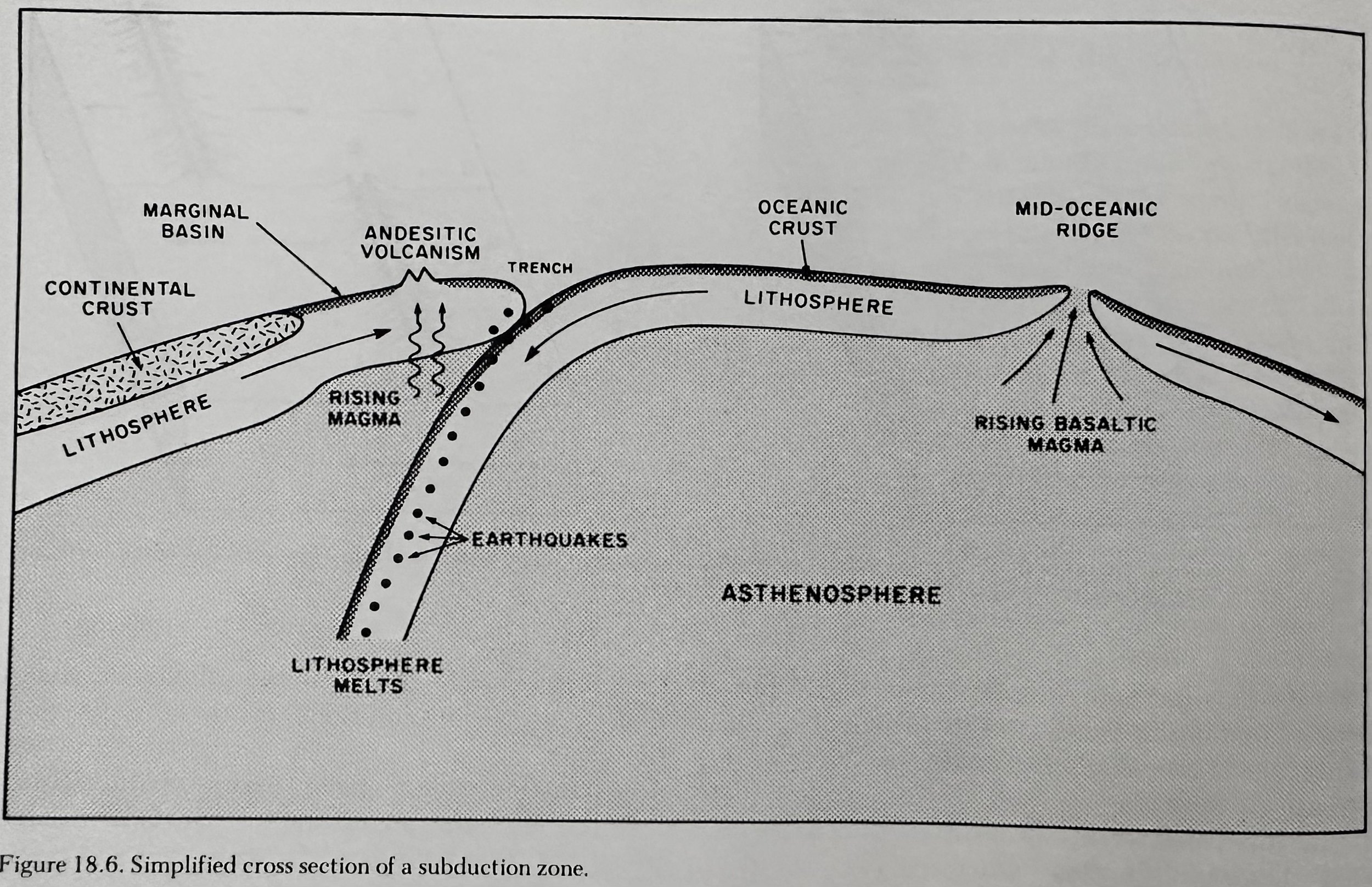
Asthenosphere (Zone of Weakness): A crystalline- liquid mixture underling the lithosphere that extends from ~70-100km to about 250km beneath the surface in which S waves are slowed and partially absorbed. The principal source of Earth’s basaltic magma.
Meteorites
Stony Meteorites: Similar in composition to the rock peridotite.
Metallic Meteorites: Composed primarily of an alloy of Ni and Fe.
__________________________________________________________________________________
---Geology of Hawaii Island---
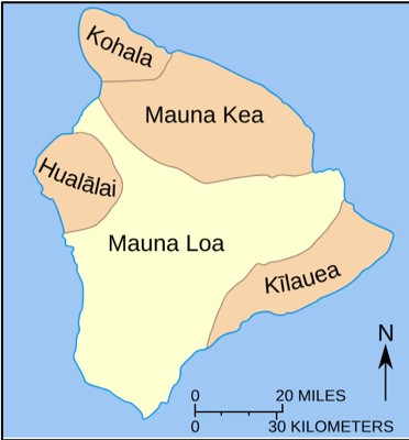
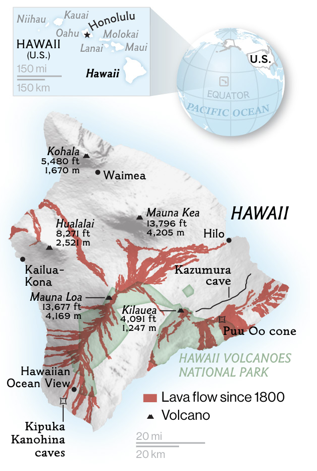
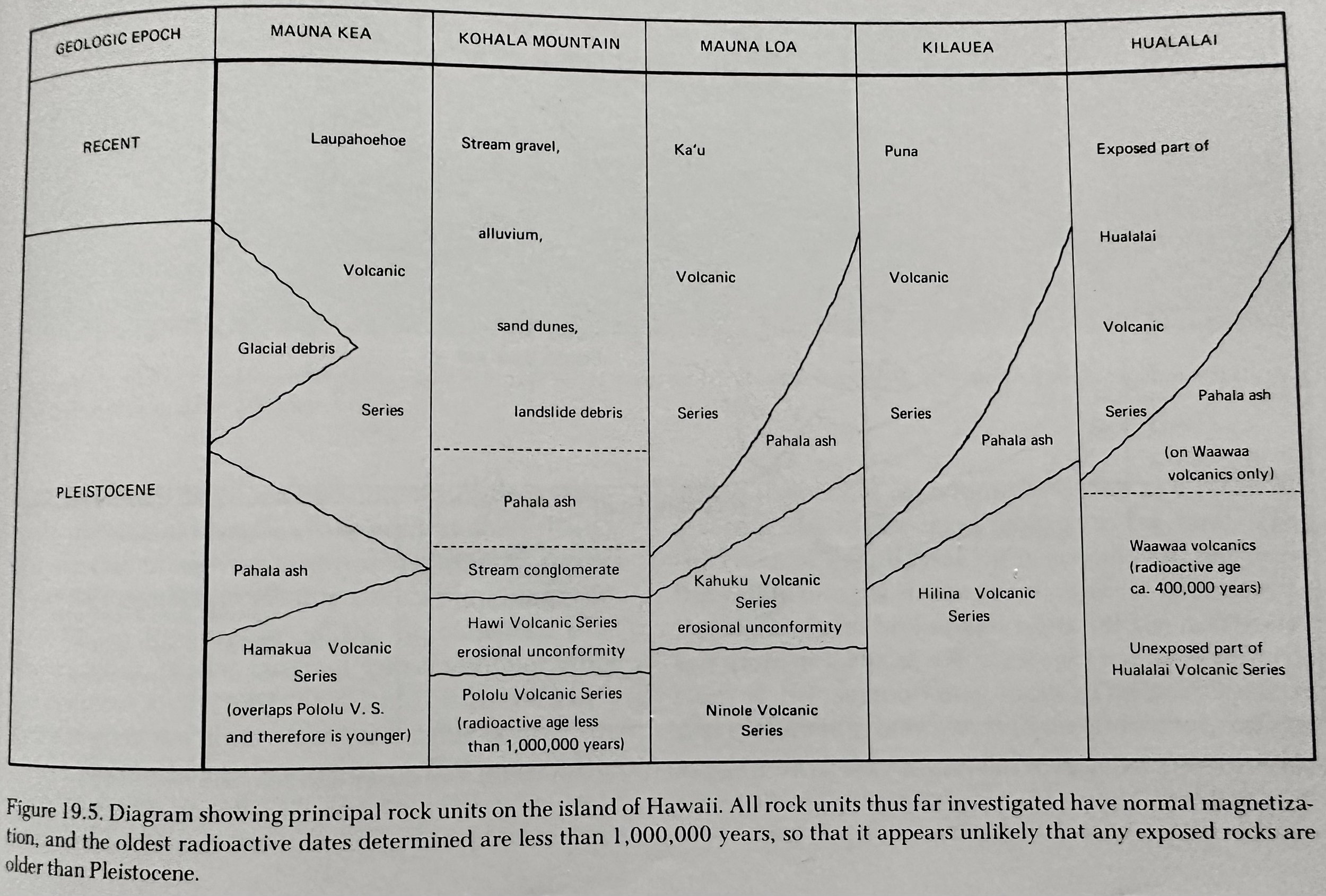
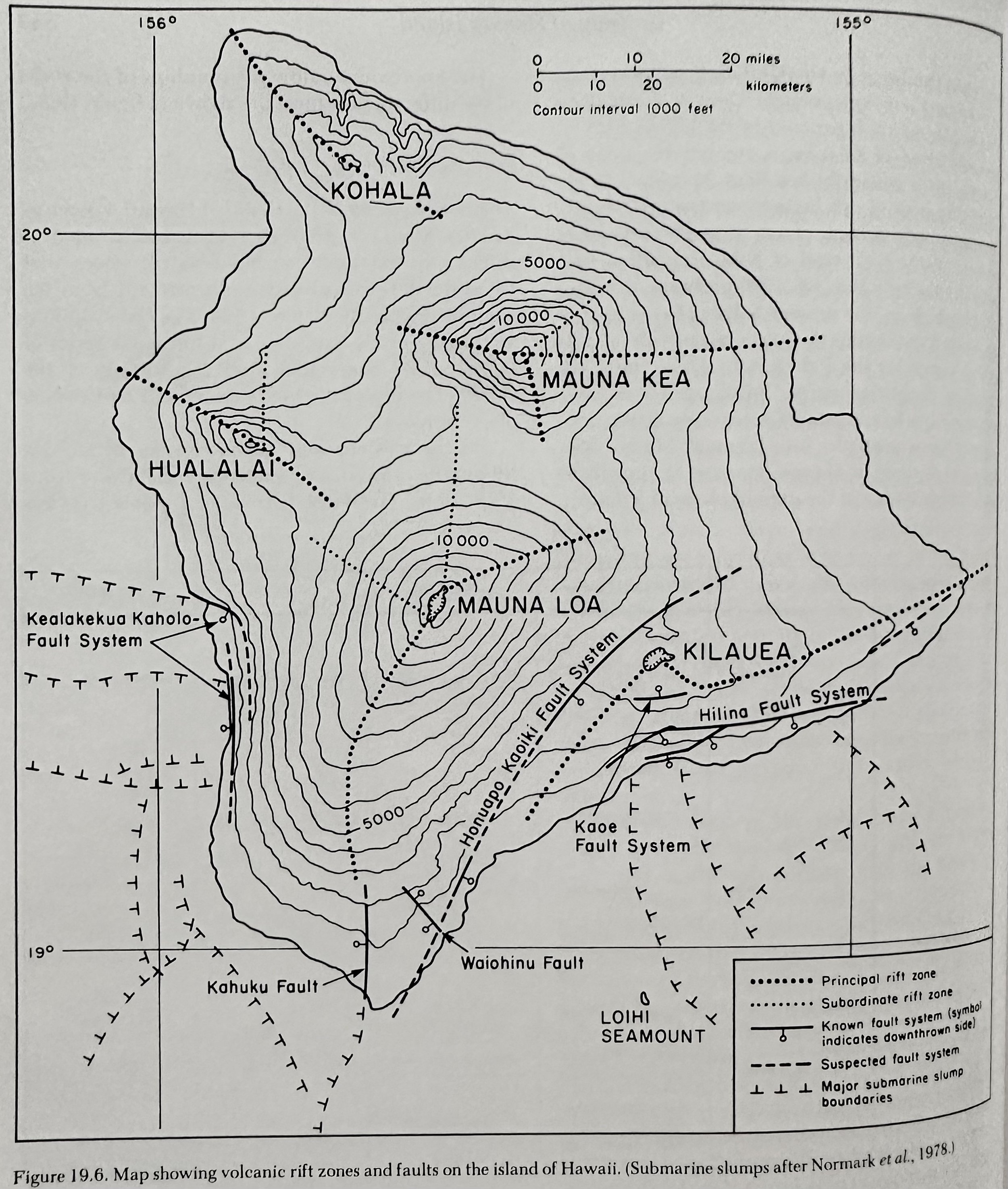
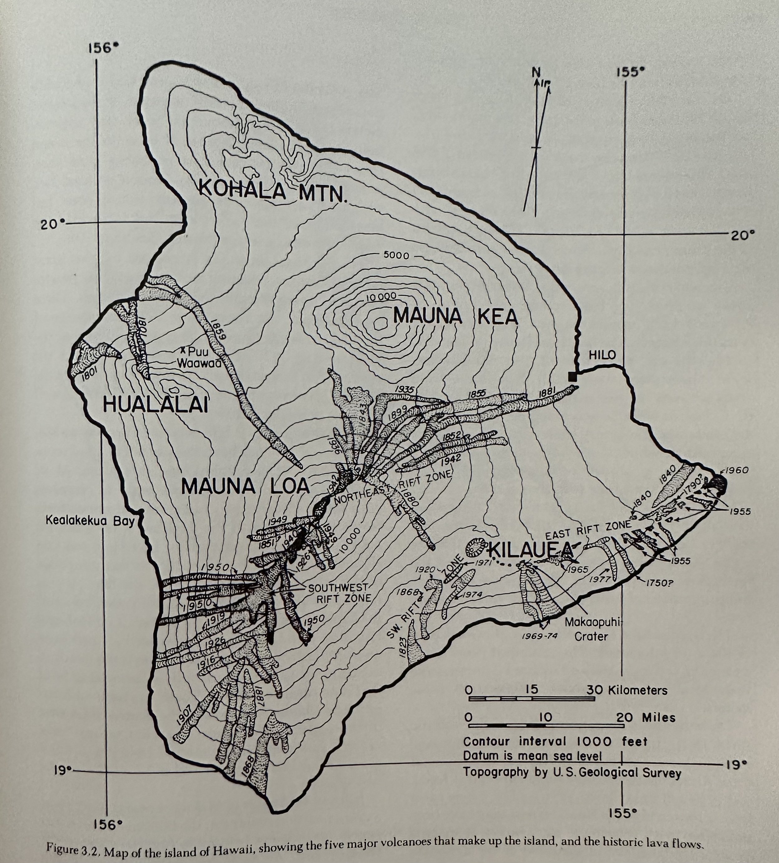
Hawaii: Consists of 5 volcanoes; Kohala, Mauna Kea, HualaIlai, Mauna Loa, and Kilauea.
__________________________________________________________________________________
Kohala
A single oval shaped shield volcano built along two rift zones that trend NW and SE; form the N. end of Hawaii.
Rock Series/Timeline
Shield Building: Pololu Volcanic Series
Dormant/Erosion Period: Separates underlying Pololu by more recent Hawi.
Rejuvenated: Hawi Volcanic Series
__________________________________________________________________________________
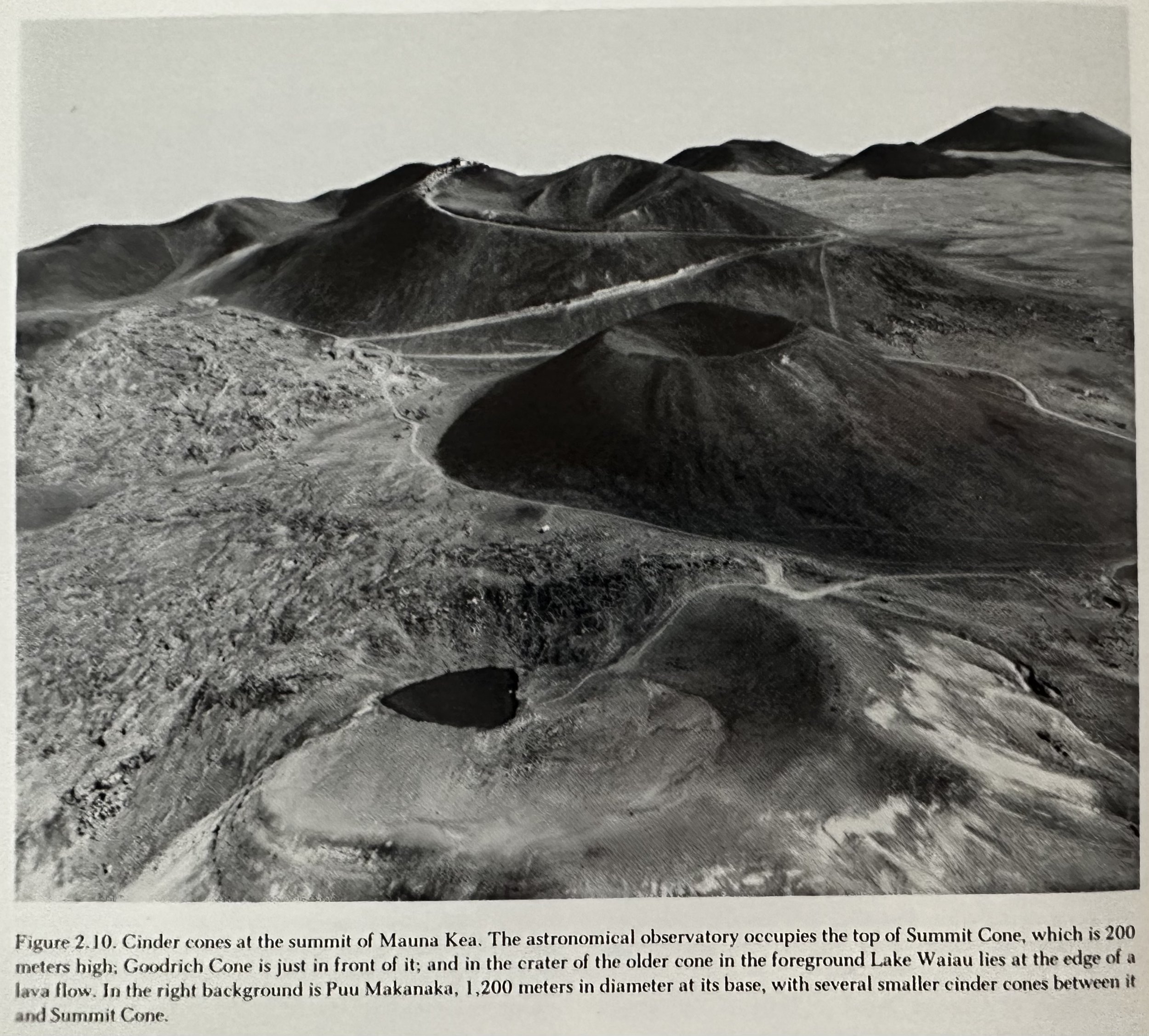
Mauna Kea
Rock Series/Timeline
Shield Building: Hamakua Volcanic Series
Dormant/Erosion Period:
Rejuvenated: Laupahoehoe Volcanic Series; created the large cones south of the Saddle Road that project through later Mauna Loa lava flows.
__________________________________________________________________________________
Hualalai
A dormant shield volcano on Hawaii’s W. side that last erupted in 1800-1801.
Rock Series/Timeline
Shield Building: Hualalai Volcanic Series.
Dormant/Erosion Period:
Rejuvenated: Waawaa Volcanic Series; created the large cones south of the Saddle Road that project through later Mauna Loa lava flows.
__________________________________________________________________________________
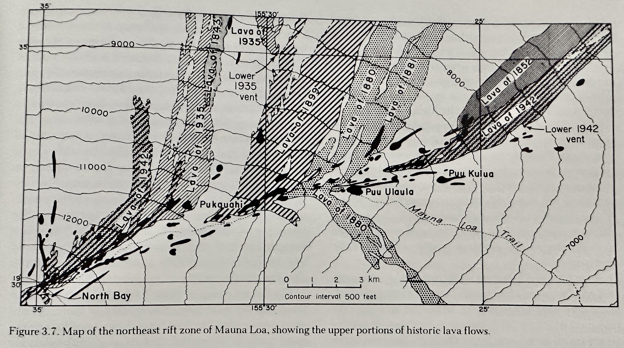
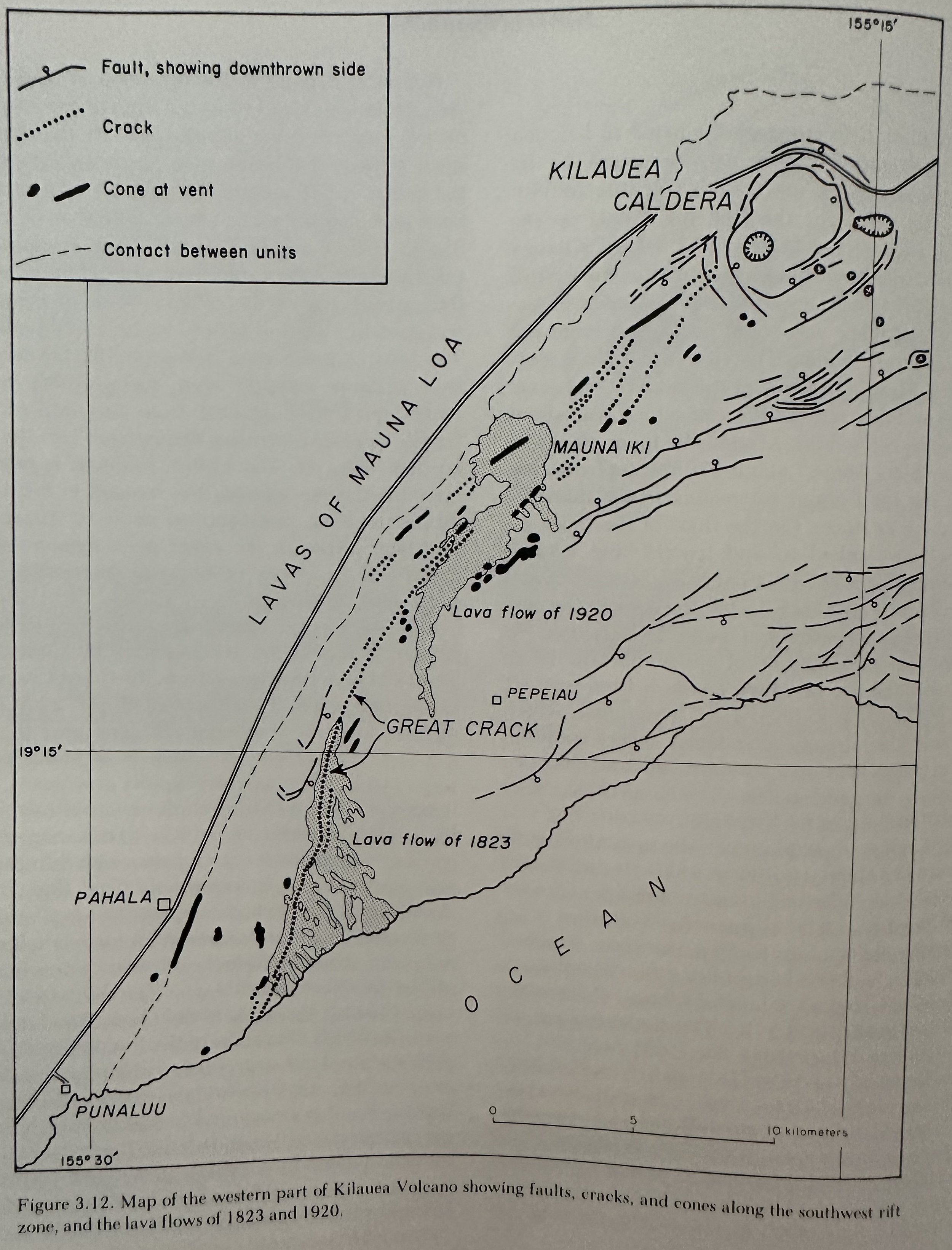
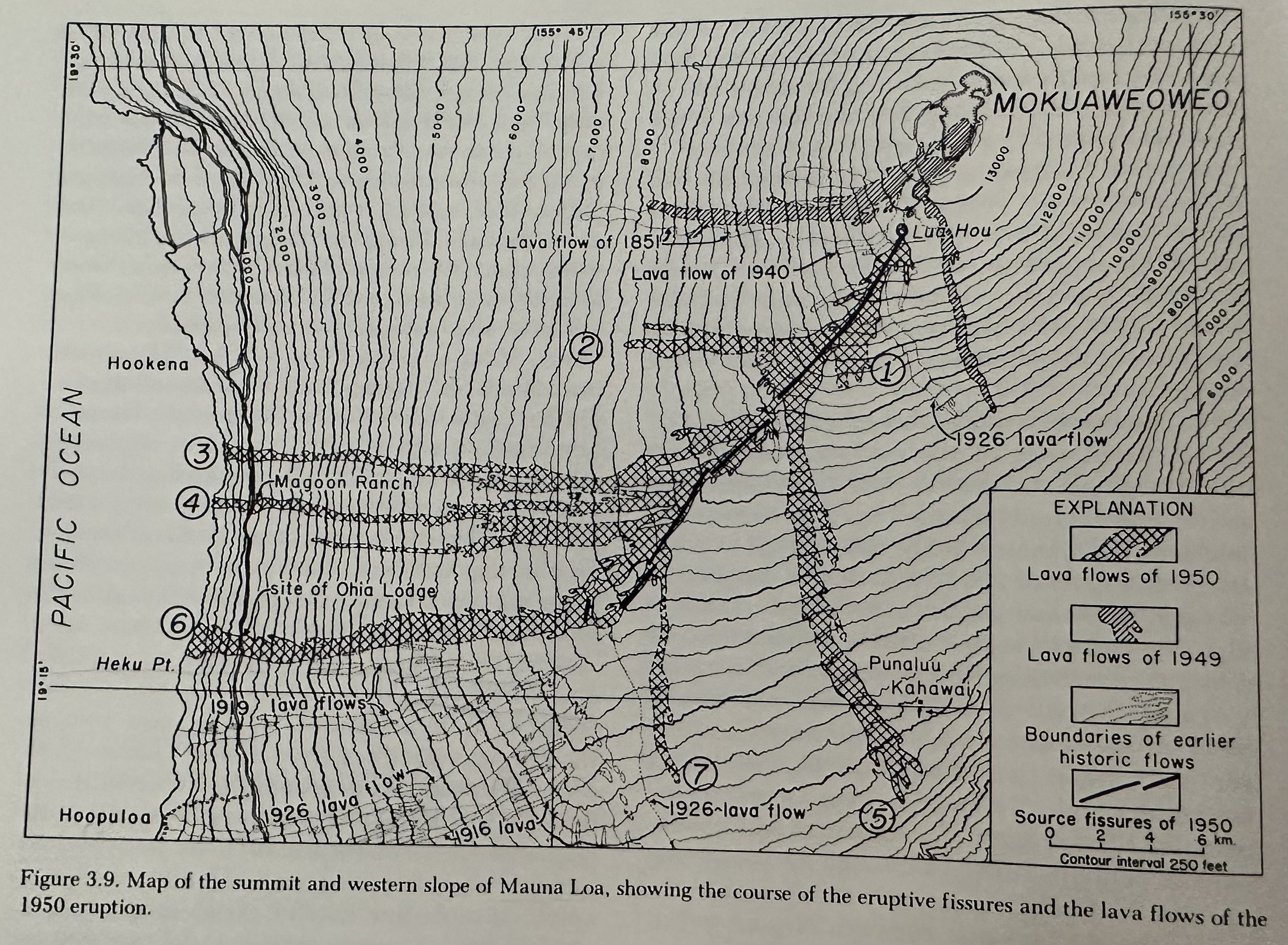
Mauna Loa
A 4103m shield volcano built atop the buried Ninole Shield (~8700m above its base on the ocean floor). Mauna Loa is on the order of 42km3, making it probably the largest volcanic mountain on Earth. The Mauna Loa shield has been built in ~1M years principally by eruptions along two rift zones that extend SW and ENE from the caldera. The rift zones are marked by scores of open cracks, a few cm to a few m wide, along many of which spurting lava has built spatter ramparts as much 7m high. Where the eruptions are centralized in big lava fountains, the ramparts merge into cinder and spatter cones.
Pahala Ash: ~15m deep yellowish-volcanic ash; the remnants of the Ninole Volcano.
Caldera: Mokuaweoweo; 4km long, 2.4km wide. The cliff bounding it on the W. is 180m high, but the one on the E. is only 70m, and both decrease in height northward to only about 3m at the NE edge.
Rock Series/Timeline
Shield Building: Older Ninole, Younger Kahuku, and present Ka’u Volcanic Series.
Dormant/Erosion Period: TBD.
Rejuvenated: TBD.
Eruption Cycle
Harmonic Tremor: Trembling of the ground that accompanies movement of molten lava in the feeding conduits of the volcano.
Opening Phase: A long line of lava founts form along the flank (curtain of fire)
Cone- Building Phase: The length of the erupting fissure diminishes; the fountain restricts to a short section.
Declining Phase: There is a general decrease in fluid pressure at the vents. The outflow of lava may cease with the dying of the fountains but commonly continues for days, weeks, even months.
Features:
Puu Mahana: Wave erosion has destroyed the seaward side of Puu Mahana, and grains of olivine from the cone have been concentrated in a small bay to form one of the best green sand beaches in Hawaii.
Gravitational Slumping: It has long been hypothesized that the steep western flank of Mauna Loa’s SW rift zone is due to seaward gravitational slumping.
Rainbow Falls: At sometime within the last few millennia, the river was able to cut a shallow gorge, seldom more than 15m deep, along the edge of the Mauna Loa lavas. Still later, the gorge was refilled by another lava flow, which in turn is now being eroded. A cross section of the flow can be seen at Rainbow Falls in Hilo, where at the north edge of the plunge pool, the old valley floor can be seen sloping Southwards overlain by the later lava.
__________________________________________________________________________________
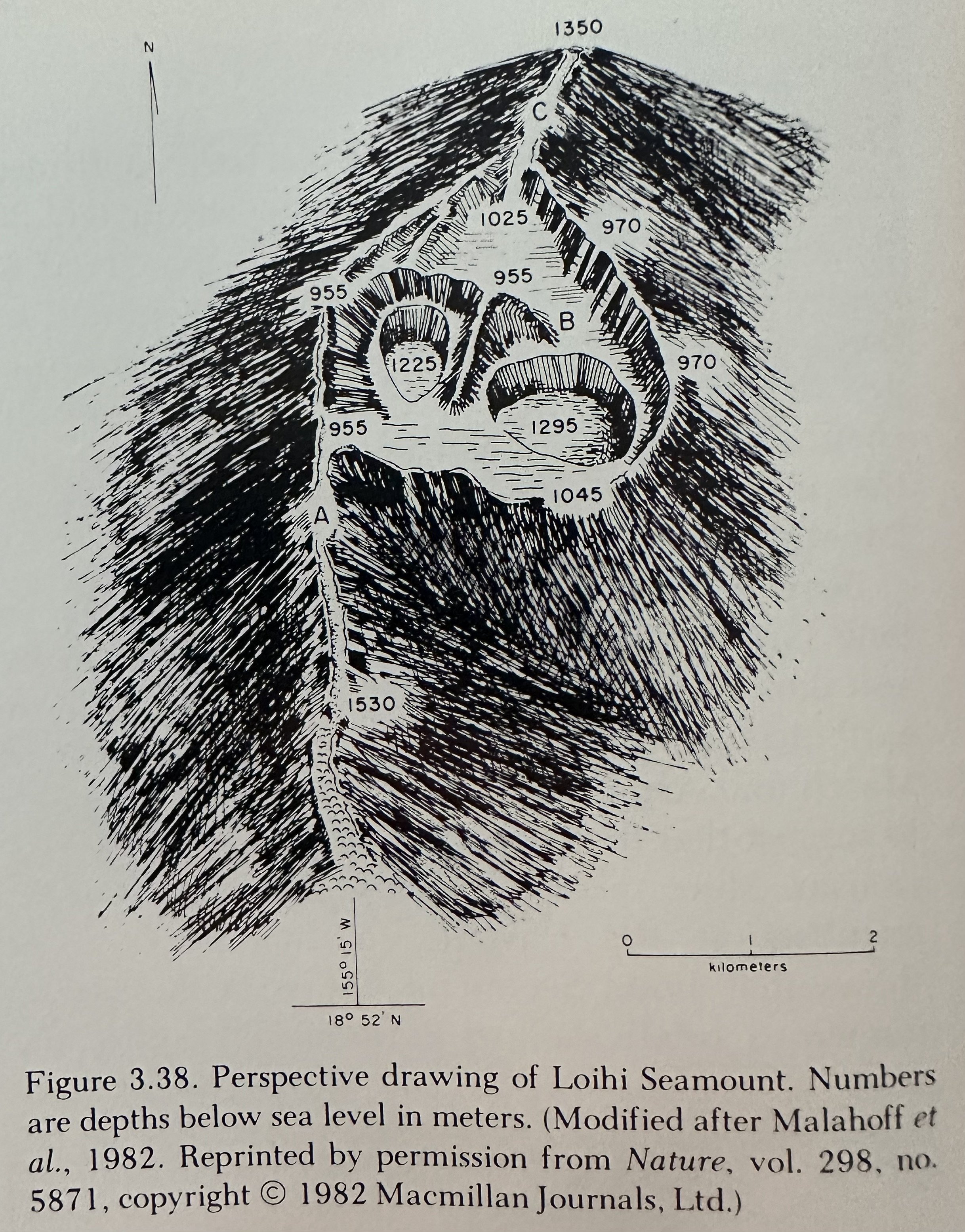
Loihi
Consists of three principal structural elements; a S. Rift, a N. Rift, and a Summit Crater ~2800m wide and 3200m long with two smaller craters within it.
__________________________________________________________________________________
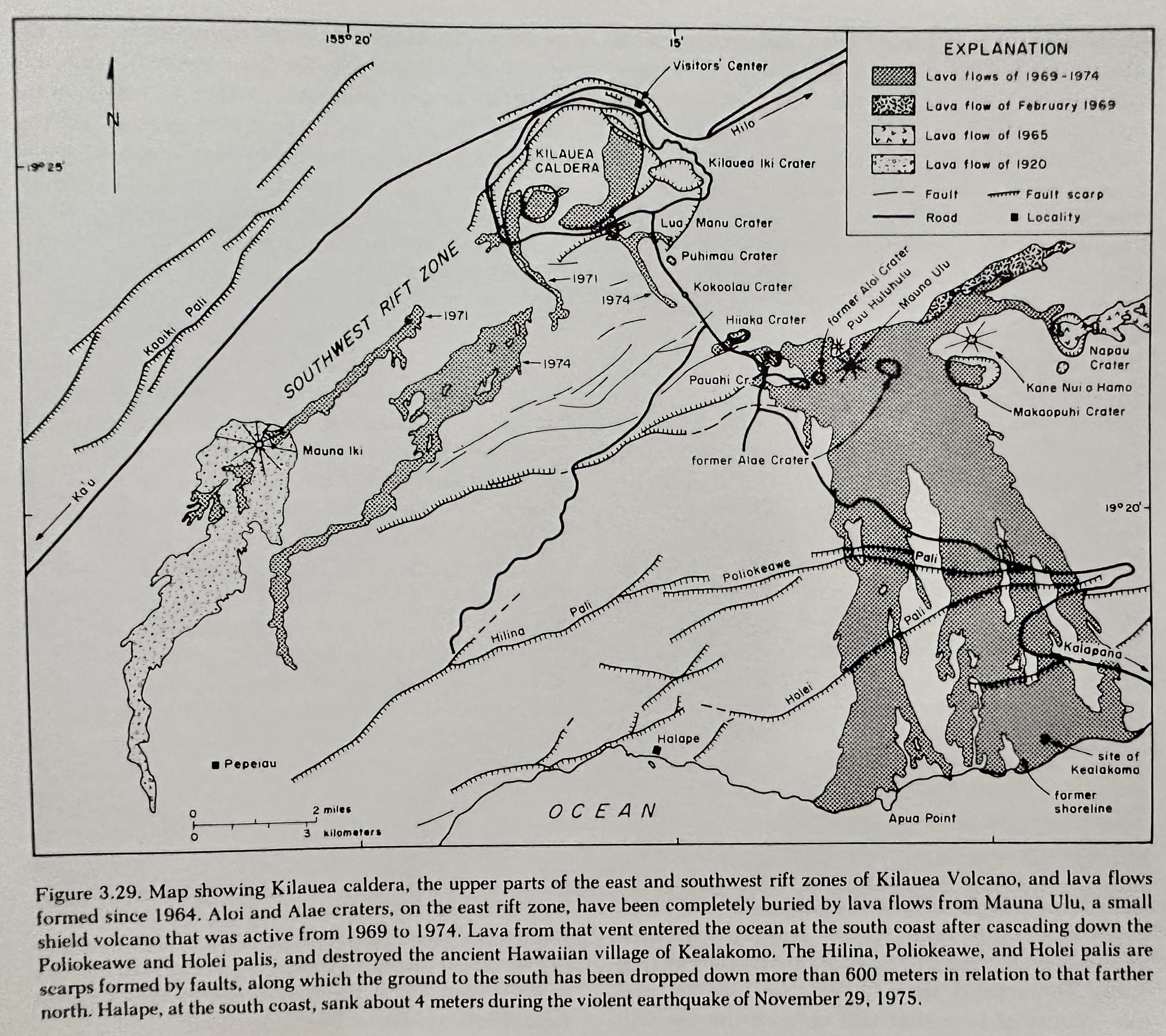
Kilauea
Forms only a slight protuberance on the SE flank of Mauna Loa. There has been little correlation between activities of Kilauea and Mauna Loa, indicating the two volcanoes are fed from different magma bodies at depth.
Magma Chamber: Earthquakes at depths of 40-50km probably mark the zone of generation of new magma, which rise into the shallow reservoir only 5km or so beneath the surface. Shallow earthquakes reflect the readjustment of the rocks to the swelling of the mountain, setting the stage for eruption.
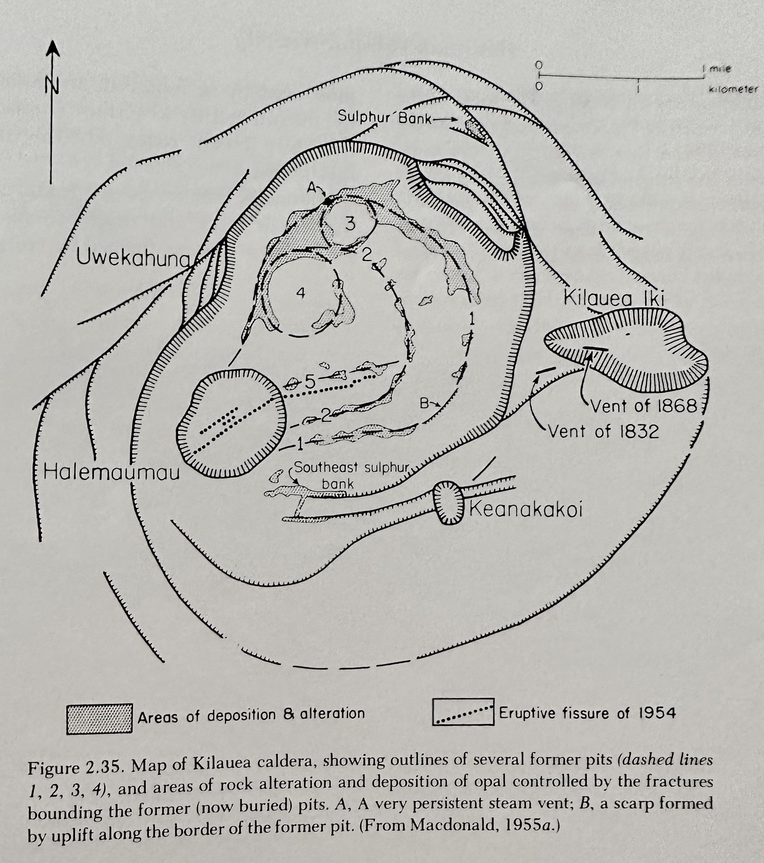
Caldera: Halemaumau; a collapse crater that occupies the top of a very flat cone or shield which slopes off in all directions to the edge of the caldera floor. Halemaumau has been the focus of activity for the last 150y.
Rock Series/Timeline
Shield Building: Older Hilina Volcanic Series capped by Pahala Ash followed by the younger Puna Volcanic Series.
Dormant/Erosion Period: TBD.
Rejuvenated: TBD.
Features
Gravitational Slumping: As forceful injection of magma into Kilauea’s E. and SW rifts produce substantial dilation of the rift zones, gravitational and magma- induced stresses build up, and the entire S. flank becomes unstable and periodically breaks loose along faults.
__________________________________________________________________________________
---Geology of Maui Nui---
Maui (Nui): Comprised of ~6 major and one minor volcanoes. At present, the lower saddles between the volcanoes are flooded by shallow sea water, dividing the massif into four separate islands- Maui, Kahoolawe, Lanai, and Molokai. At times of lower sea level, they have all been united as a single large island, called Maui Nui.
__________________________________________________________________________________
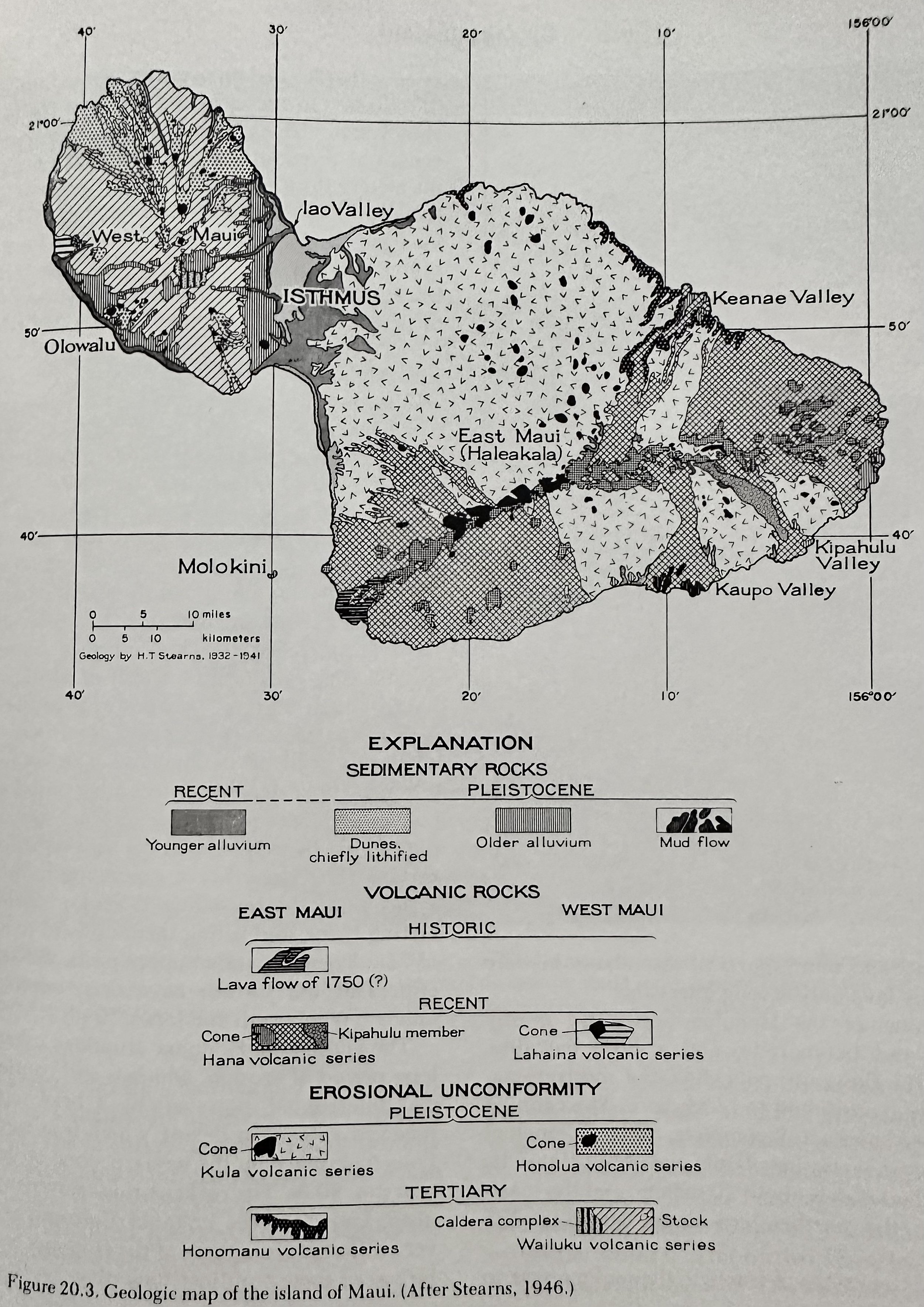
Maui
Consists of two major volcanoes; older W. Maui & younger E. Maui (Haleakala).
W. Maui Rock Series/Timeline
Shield Building: Wailuku & Honolua Volcanic Series.
Dormant/Erosion Period:
Rejuvenated: Lahaina Volcanic Series.
E. Maui (Haleakala) Rock Series/Timeline
Caldera: ~11km long, 3km wide, .8km deep.
Shield Building: Honomanu Volcanic Series.
Dormant/Erosion Period:
Rejuvenated: Kula OR Hana? Volcanic Series Hana is low in Silica.
Features: Molokini islet is a tuff cone on the SW rift zone of Haleakala.
__________________________________________________________________________________
Kahoolawe
A single shield volcano with a caldera 5km in diameter.
Rock Series/Timeline
Shield Building: Kanapou Volcanic Series.
Dormant/Erosion Period:
Rejuvenated: Unk.
__________________________________________________________________________________
Lanai
A single shield volcano built by eruptions at the summit and along three rift zones.
Rock Series/Timeline
Shield Building: Wainae Volcanic Series.
Dormant/Erosion Period:
Rejuvenated: Unk.
Features: Three of the localities in the Hawaiian Islands at which evidence of former high stands of the sea were first recognized are on Lanai. Fossiliferous marine conglomerate and remnants of a wave-cut terrace occur 170m above sea level in Kaluakapo Crater and on the S. rim of the crater, fossiliferous limestone lies at 188m altitude.
Rate of Erosion: ~1m/16,600y (based on burial rate of Kiawe trees and other factors- Wentworth).
__________________________________________________________________________________
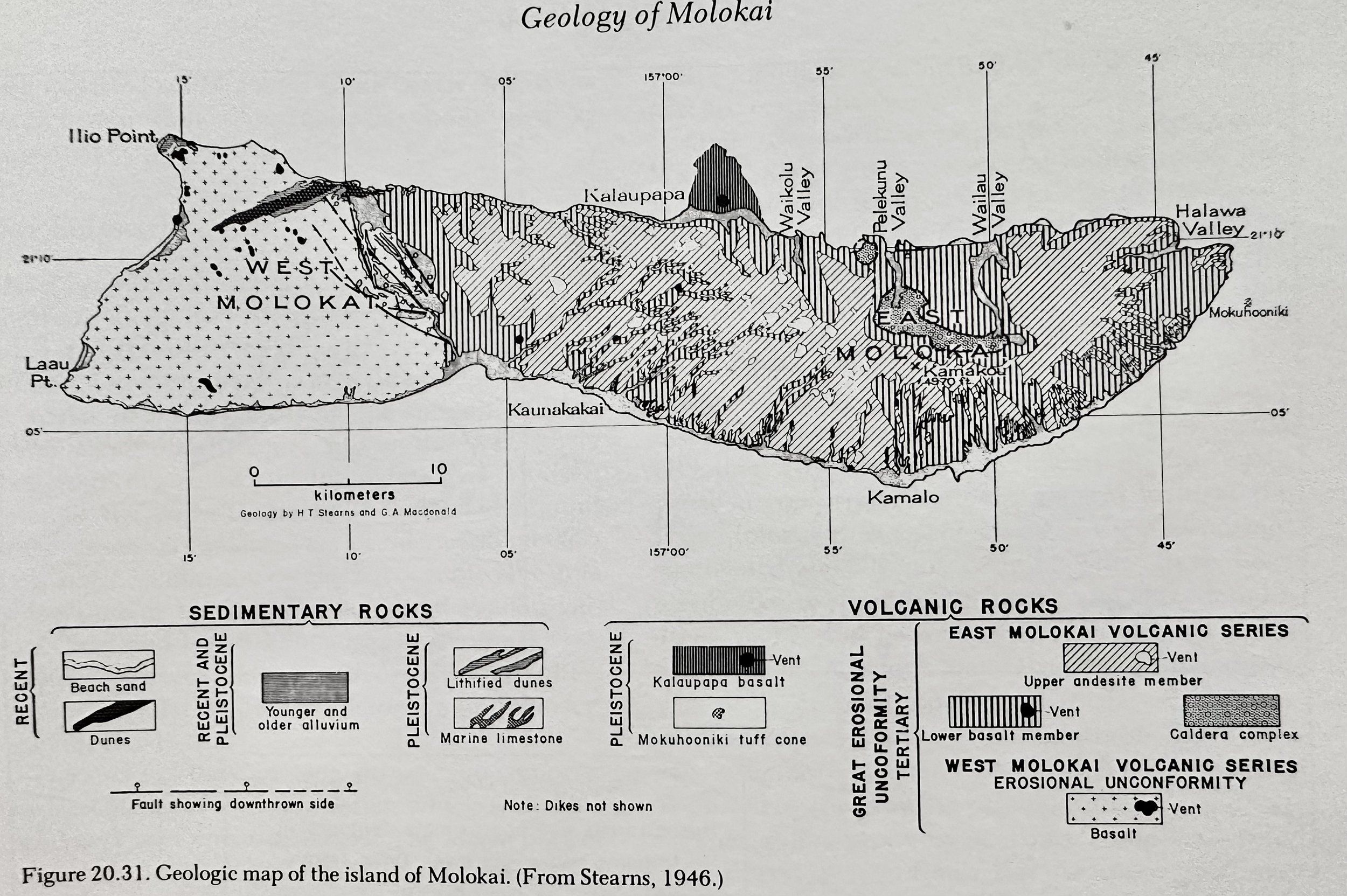
Molokai
Comprised of two volcanic shields, the E and W Molokai, which overlap its E. flank, forming the Molokai isthmus.
West Molokai Rock Series/Timeline
Shield Building: W. Molokai Volcanic Series.
Dormant/Erosion Period:
Rejuvenated: Unk.
Features: Beneath the sea, W. Molokai is prolonged almost 65km W-SW by Penguin bank, the broad, nearly flat shoal which lies 54m below sea level. Penguin bank almost certainly was truncated by wave action.
Sand is imported from W. Molokai to places like Waikiki Beach.
East Molokai Rock Series/Timeline
Shield Building: E. Molokai Volcanic Series.
Dormant/Erosion Period:
Rejuvenated: Unk.
Features: In the E. walls of Pelekunu Valley 3 large springs with a total flow of about 3.8M liters a day are perched on tuff beds.
__________________________________________________________________________________
---Regional Geology of Oahu---
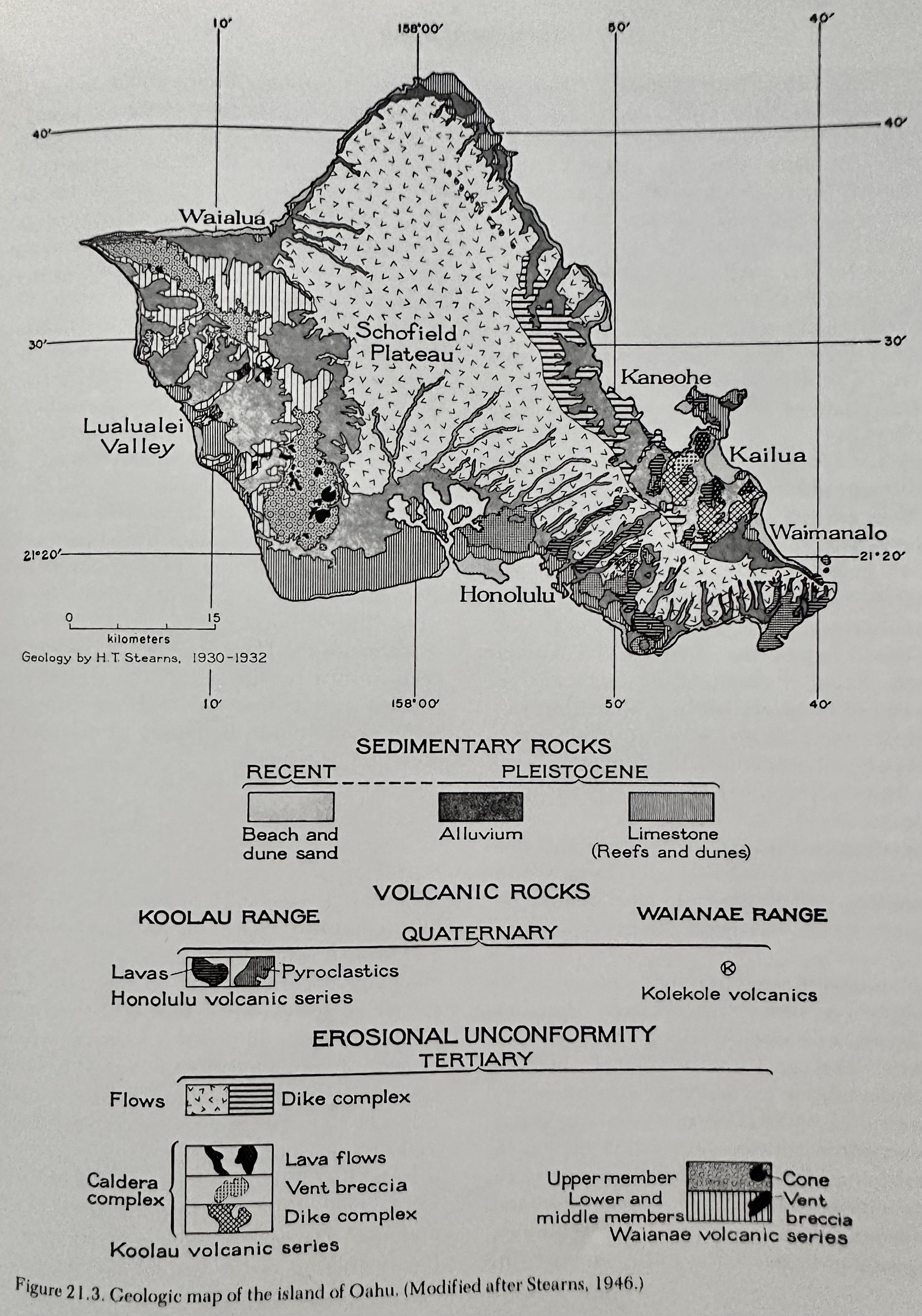
Comprised of two volcanic shields, the Western Wainae and the younger Eastern Koolau.
__________________________________________________________________________________
Wainae
Wainae Rock Series/Timeline
Shield Building: Wainae Volcanic Series.
Dormant/Erosion Period:
Rejuvenated: Kolekole Volcanic Series.
__________________________________________________________________________________
Koolau
Koolau Rock Series/Timeline
Shield Building: Koolau Volcanic Series.
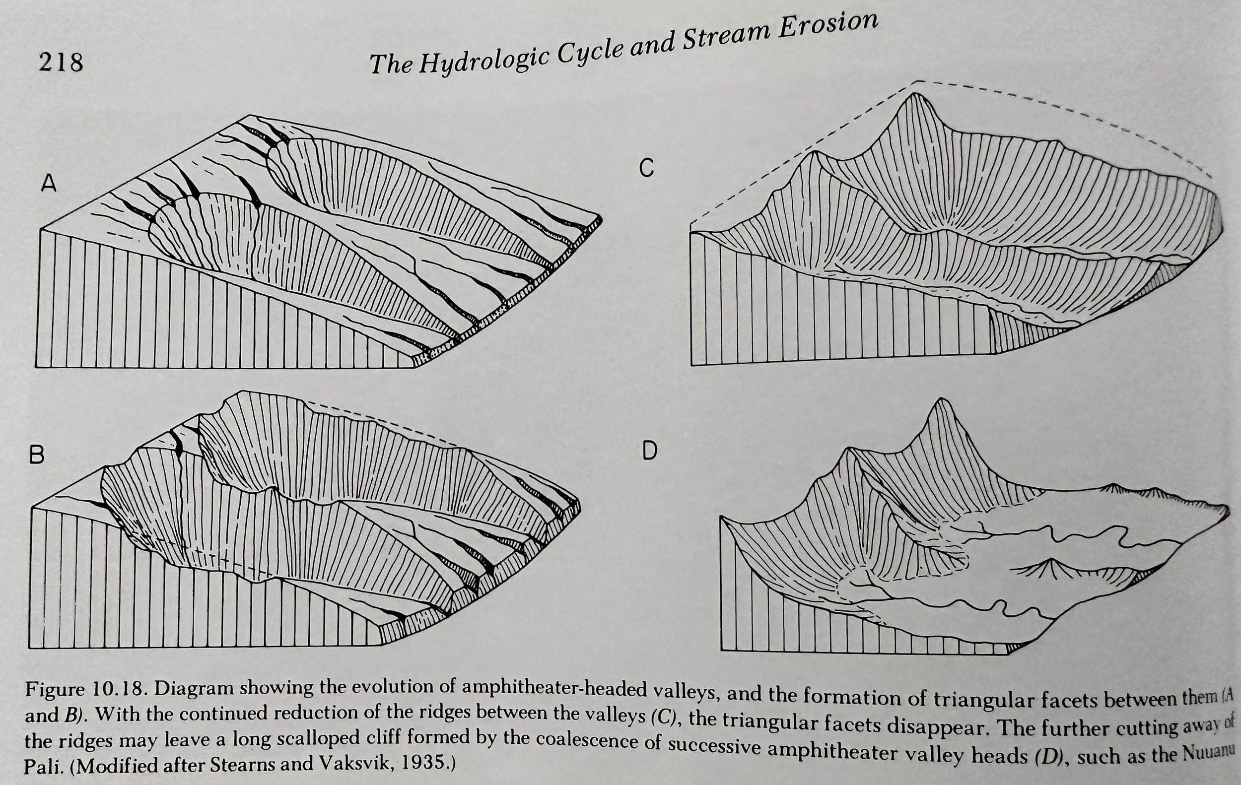
Dormant/Erosion Period: ~2M years in which deep erosion of the E. flank of the shield was removed, great valleys more than 600m deep were cut into the rest of the range, the Nuuanu Pali was formed, and alluvium accumulated in the valleys as the island slowly sank at least 360m.
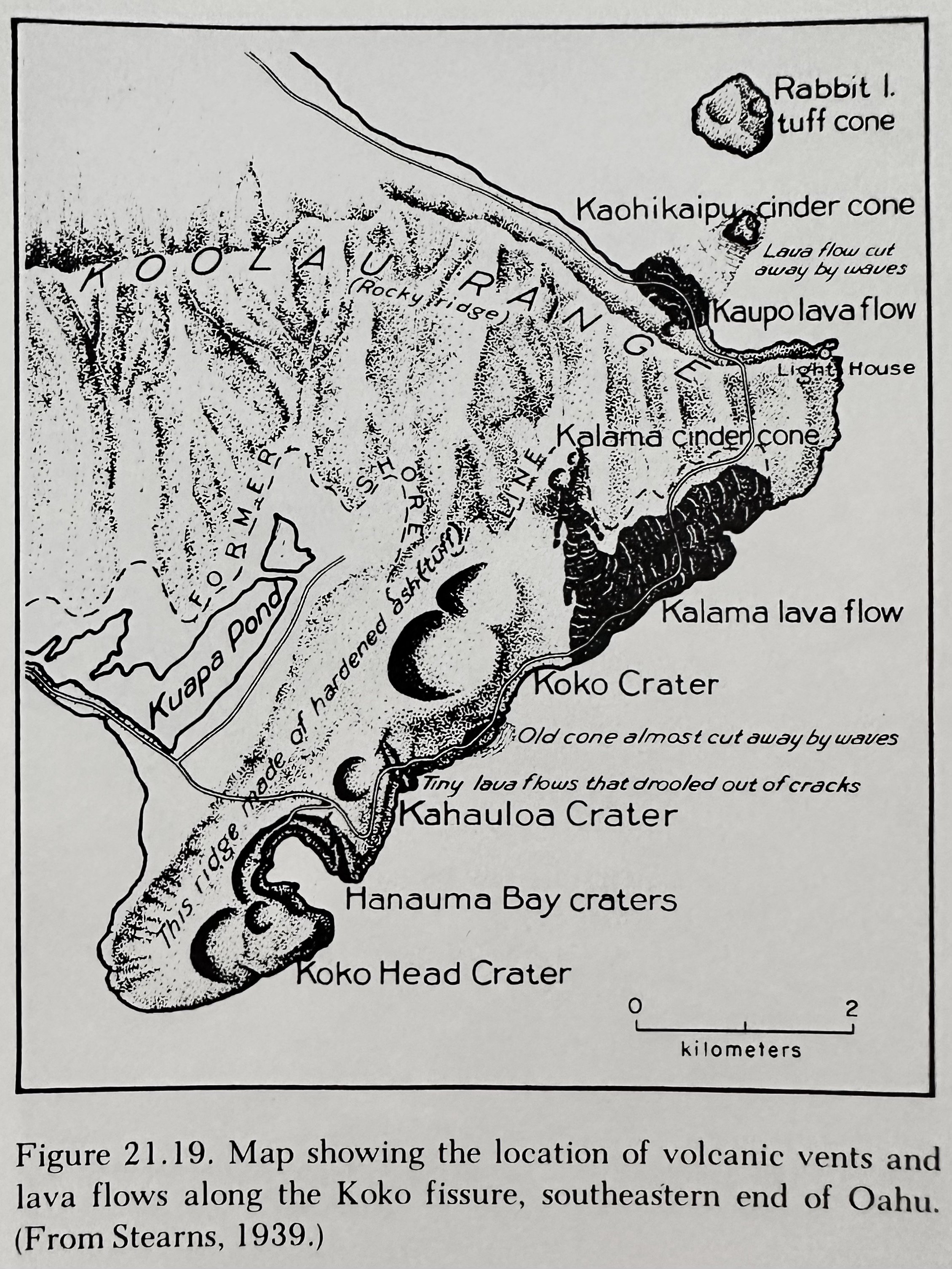
Rejuvenated: Honolulu Volcanic Series on the SE end of the Koolau range with more than 30 separate eruptions including Diamond Head, Koko Head, Kaau Crater, Hanauma Bay, Punchbowl, Salt Lake, Tantalus.
Features
Exposure of dikes can be seen in the cuts on the Pali Highway near Castle Junction, 5km SW of Kailua.
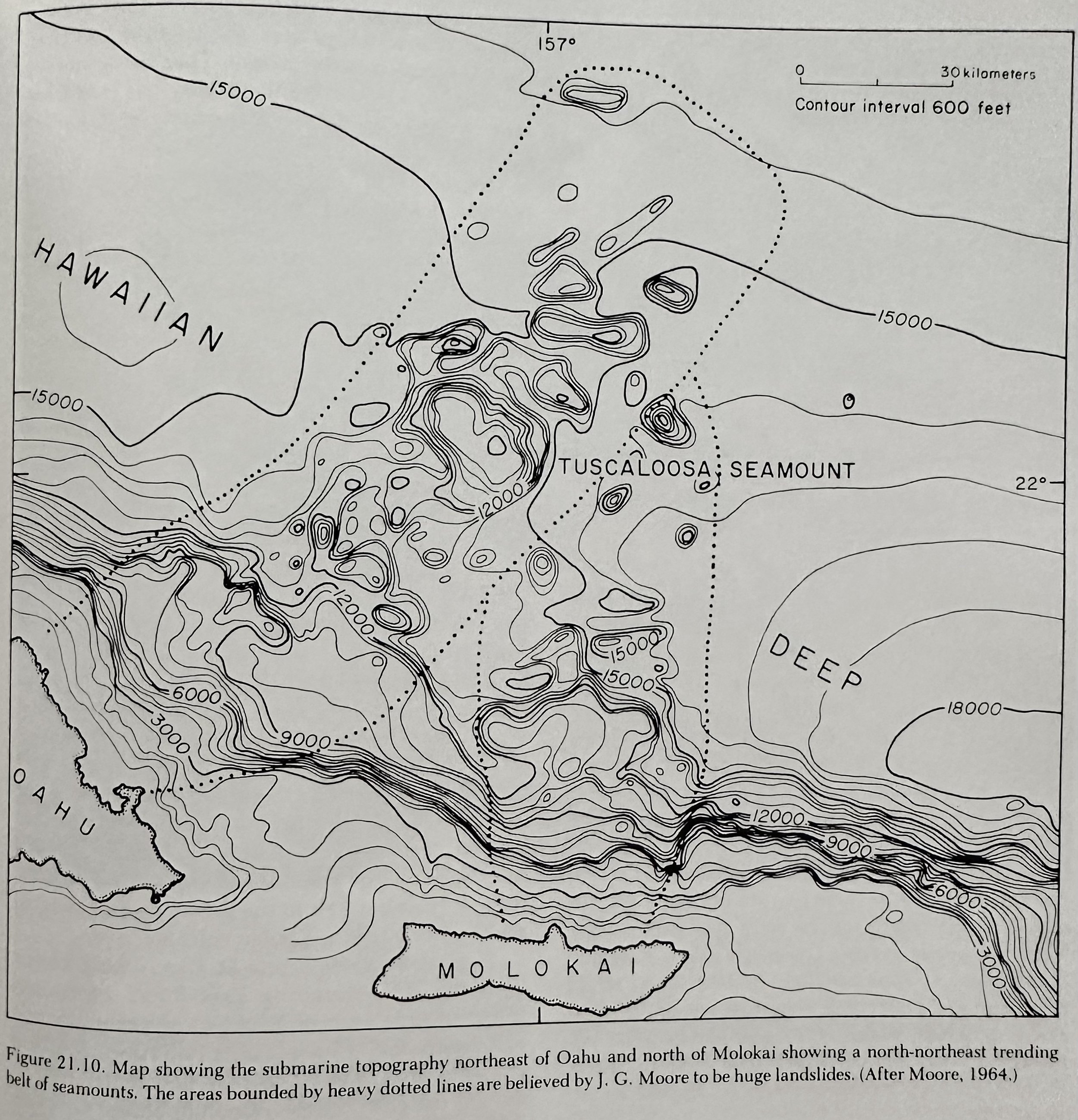
NE of Kailua and Kaneohe a belt of hilly topography lies on the ocean floor, and it has been suggested. The undersea hills are very large as compared with the bumps on known landslides, and some of them have forms characteristic of volcanic cones.
__________________________________________________________________________________
---Geology of Kauai & Niihau---
__________________________________________________________________________________
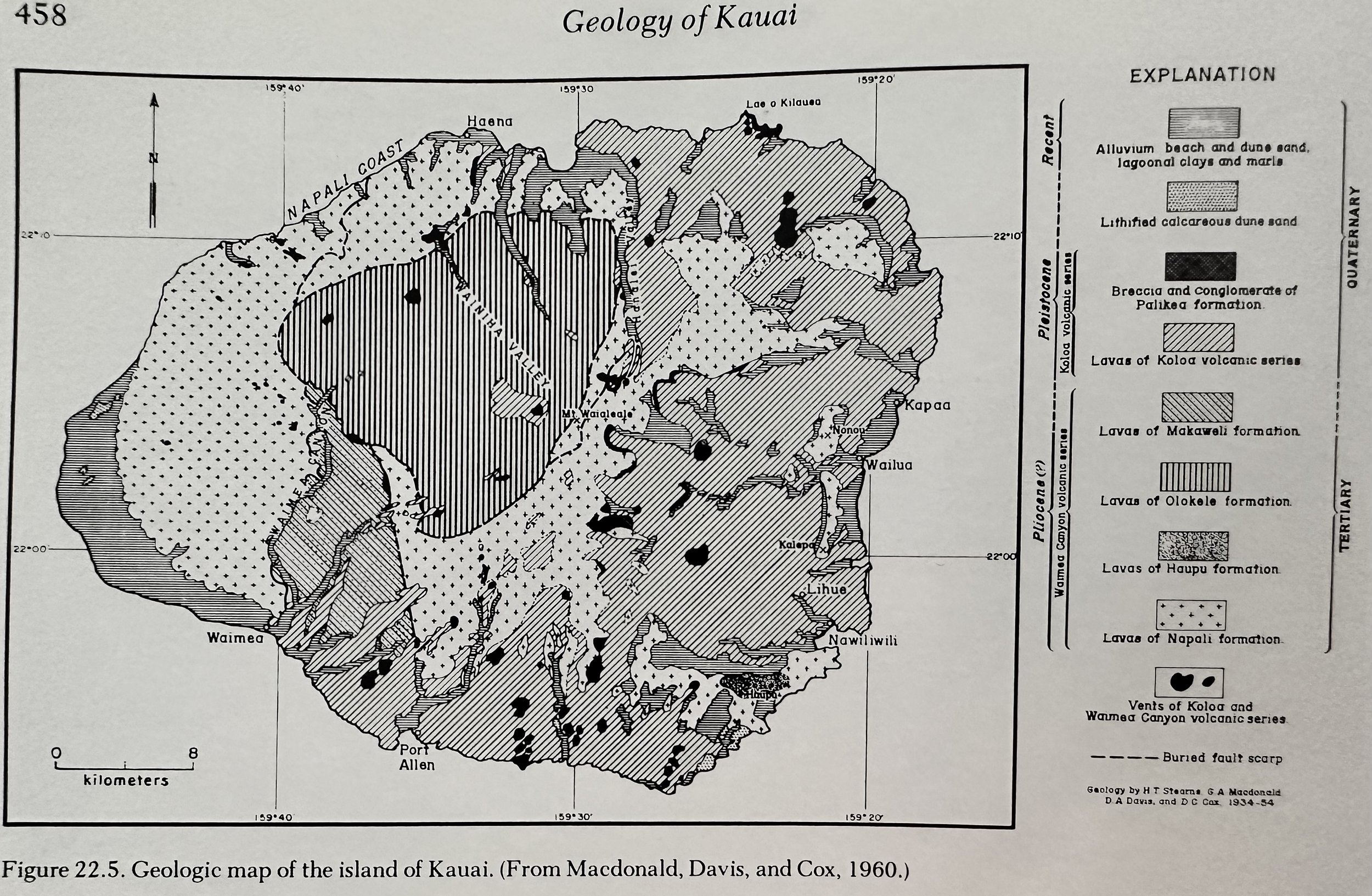
Kauai
A single great shield volcano, which is deeply eroded and partly veneered with much later volcanism.
Caldera: 15-20km across, the largest in the Hawaiian Islands.
Rock Series/Timeline
Shield Building: Waimea Canyon Volcanic Series.
Dormant/Erosion Period: ~1.5M years which included the Palikea formation of rockslides and mud slides that interbedded with the Koloa series.
Rejuvenated: Koloa Volcanic Series with ~40 vents, scattered over the E. two thirds of Kauai.
Features
Napali Cliffs: Built by the combined erosive power of running water and waves.
__________________________________________________________________________________
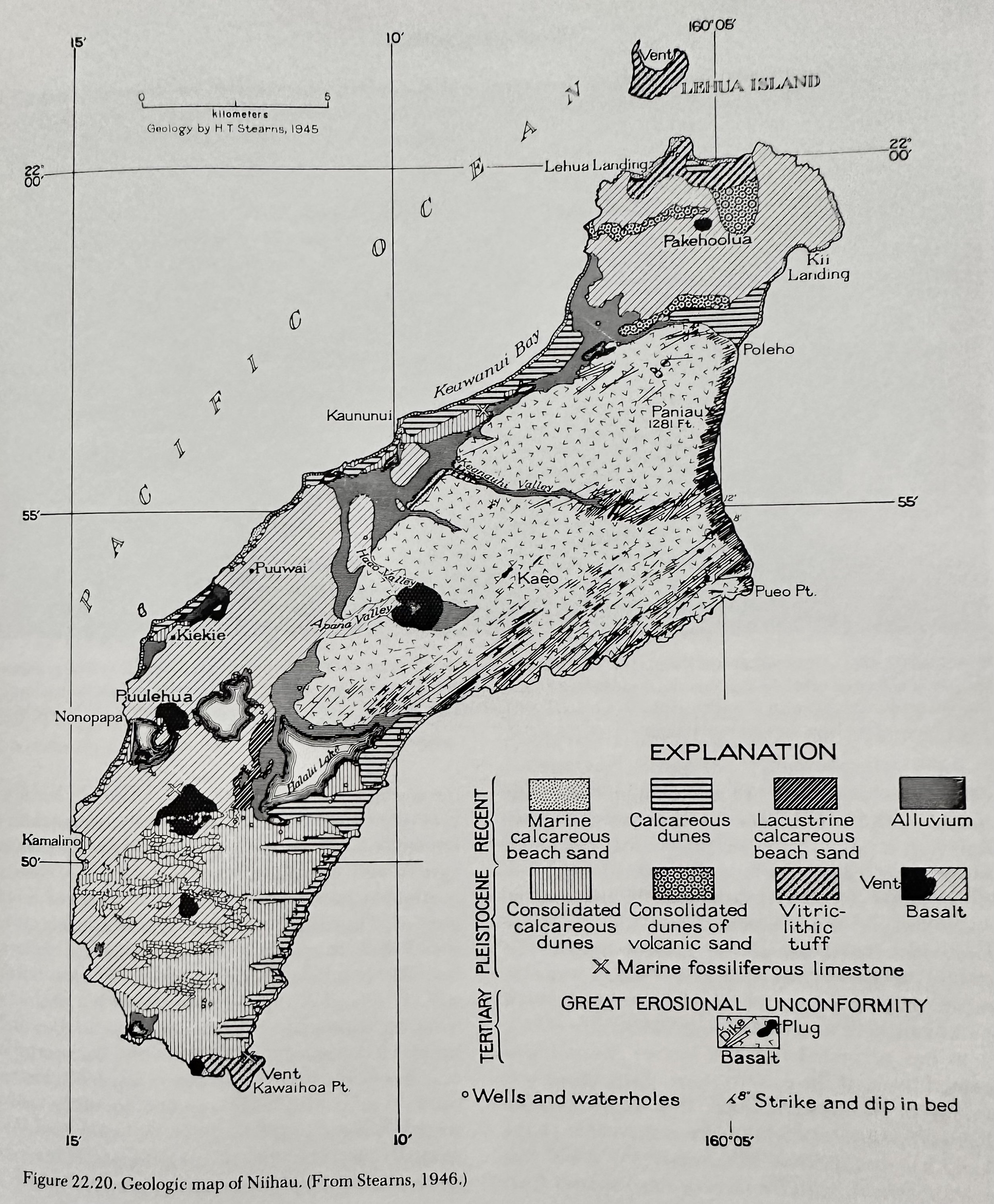
Niihau
A single deeply eroded shield volcano fringed by much later, rejuvenated period volcanism.
Rock Series/Timeline
Shield Building: Paniau Volcanic Series.
Dormant/Erosion Period:
Rejuvenated: Kiekie Volcanic Series.
__________________________________________________________________________________
---Geology of the NW Hawaii Islands---
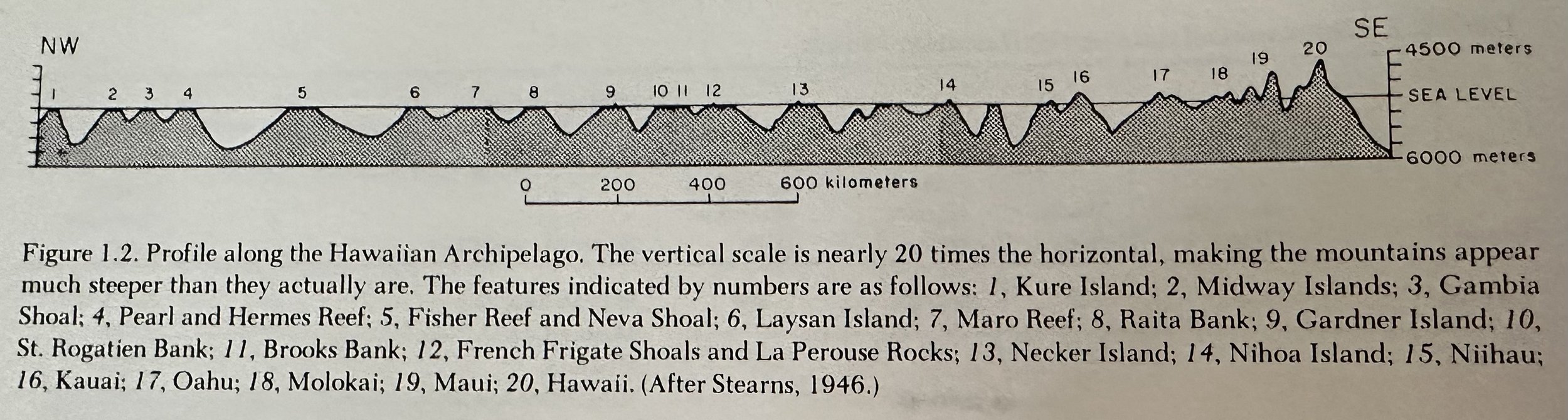
Islands from SE to NW: Kaula, Nihoa, Necker, French Frigate Shoals, Gardner, Laysan, Maro Reef, Lisianski, Pearl and Hermes Reef, Kure and Midway.
__________________________________________________________________________________
Misc Quotes
The introduction of sheep in the mid-19th century resulted in destruction of the plant cover and exposed the soil to wind action.
The invasive Kiawe (algaroba) trees intercept and transpire back into the atmosphere much of the fresh rain water that formerly filtered down to the water table.
Earth’s Composition: 8 elements make up 98.5% of the Earth’s crust; O: 46.6%, Si: 27.7%, Al: 81%, Fe: 5%, Ca: 3.6%, Na: 2.8%, K: 2.6%, Mg: 2.1%.
__________________________________________________________________________________
Definitions
Carbon Dating: Organisms incorporate into themselves C from the environment in which they live. The majority is in the form of isotope C-12, but cosmic rays from outer space bombard the N of the air and transform some of it to C-14. The ratio of C-14 to C-12 in the air is quite constant, and the ratio of the two carbon isotopes incorporated into organisms is the same as that in the atmosphere. After the death of an organism, the C-14 gradually disintegrates, at a constant rate, while the C12 remains the same in amount if it is not affected by outside processes. In fossil materials that have not been contaminated by addition of new C, the age of the material can be ascertained by determining the ratio of C14 to C12 in it. Because C14 breaks down quite rapidly (half-life is only about 5570y), the C method is good only for very young rocks, less than 40k years.
Cohesion: A force that holds material in place.
Curie Point: The temperature at which the strength of ordinary ferromagnetism disappears; ~500C (with increasing temperatures, the strength of ordinary ferromagnetism decreases).
Geothermal Gradient: Varies somewhat from place to place; averages ~1 degree C for every 30m of depth.
Pressure increases downwards within the earth due to the increasing weight of the mass of overlying rock, which raises the melting point of the rocks enough to keep them solid.
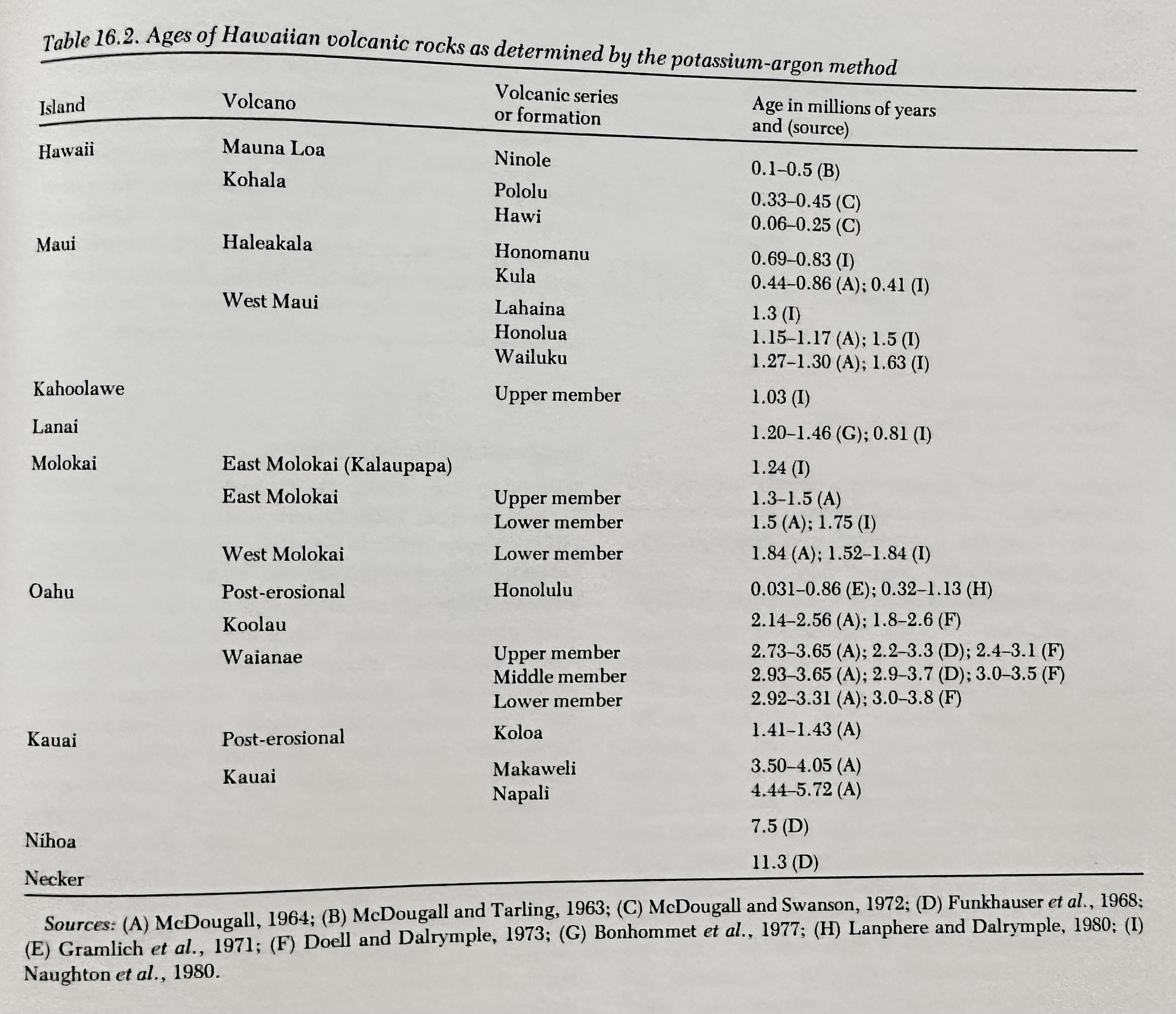
K-Ar Dating: K-40 comprises a part of the total K in the original constitution of the minerals of rocks. Its breakdown generates Ar40, which is trapped within the structure of the mineral. Determinations of the amounts of K40 and Ar40 in the mineral make it possible to calculate the age of the mineral and of the rock that contains it.
Kipuka: Undisturbed islands of land left amidst Hawaiian lava flows.
Menehunes: Proto-Hawaiian population living in the Hawaiian Islands.
Pele: The Hawaiian god of Volcanoes.
Principle of Superposition: Layers are deposited upon layers in the formation of sedimentary rocks.
__________________________________________________________________________________
Chronology
18 May, 1981: Volcanic Eruption of Mt. St. Helens is triggered by a large earthquake that causes a sizeable portion of the Volcano’s North face to collapse, producing a massive debris avalanche and mudflows. Within seconds, the resultant unloading of the summit area “uncorked” the volcanoes plumbing system and the volcano erupted violently killing 60 and causing billions of dollars in damage.-Volcanoes by MacDonald.
5 Jul, 1975: Volcanic Eruption of Mauna Loa.-Volcanoes by MacDonald.
1968: The Deep-Sea Drilling Project (DSDP) is initiated by a group of leading US Oceanographic institutions to obtain rock samples from boreholes in the ocean floor.-Volcanoes by MacDonald.
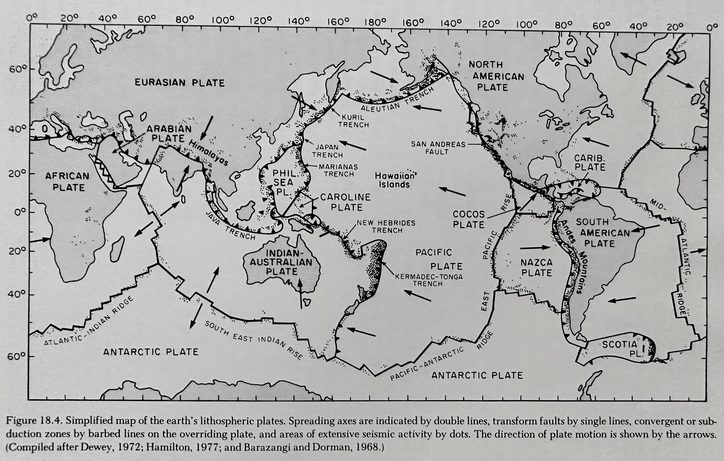
1963: Hawaiian Hot Spot Theory is first suggested by T. Wilson, hypothesizing that the pacific plate moves slowly NW over some sort of melting spot deep within the mantle, which he termed a hot spot.-Volcanoes by MacDonald.
1960: A M8.5 Earthquake is recorded in Chile, the highest ever recorded.-Volcanoes by MacDonald.
1960: Sea-Floor spreading is first proposed by American Geologist H. Hess.-Volcanoes by MacDonald.
22 May, 1956: A possible submarine eruption occurs in the channel between Oahu and Kauai.-Volcanoes by MacDonald.
1949: Eruption of Mauna Loa; the only Loa eruption in Historic time in which lava erupted within the caldera escaped onto the outer slope of the mountain.-Volcanoes by MacDonald.
1 Apr, 1946: A 7.5M Earthquake in the Aleutian Islands sets in motion a large Tsunami which strikes the Hawaiian Islands ~6h later killing >150 people; the most destructive in Hawaiian history. As a result, the Pacific Tsunami Warning System, headquartered in Honolulu, is established to monitor tsunamis in the Pacific Basin -Volcanoes by MacDonald.
1943: Volcanic Eruption of Paricutin Volcano in Michoacan, Mexico.-Volcanoes by MacDonald.
1935: The US Army Air Corps conducts bombing of a lava flow to divert it from Hilo.-Volcanoes by MacDonald.
1928: English Geologist A. Holmes proposes that the continents are driven by convection currents within the mantle.-Volcanoes by MacDonald.
1912: Continental Drift is first theorized by German Meteorologist Alfred Wegner.-Volcanoes by MacDonald.
1902: Eruption of Mt. Pelé after a Nuee Ardente destroys the entire city of St. Pierre killing all but two of the cities 30K inhabitants.-Volcanoes by MacDonald.
1883: Plinian Eruption of Krakatoa in the Sunda strait between Java and Sumatra destroys a large part of the old volcanic cone and forms a caldera on the sea floor, causing tidal waves that kills many thousands of persons on nearby shores.-Volcanoes by MacDonald.
2 Apr, 1868: A 7.5M Earthquake occurs near the S. tip of Hawaii; the islands largest in known times.-Volcanoes by MacDonald.
1832: Eruption of Mauna Loa; the first in recorded history.-Volcanoes by MacDonald.
1825: Lord George Byron returns the bodies of King Liholiho and his wife Queen Kamamalu aboard the British warship blonde to Hawaii from London, where the two had died of Measles.-Volcanoes by MacDonald.
1813: Plinian Eruption of Tambora Volcano in Indonesia.-Volcanoes by MacDonald.
~1800: Eruption of Hualalai Volcano in W. Hawaii.-Volcanoes by MacDonald.
1790: Eruption of Haleakala Volcano in Maui after lava breaks from two vents on the SW rift zone pouring into the sea at Makena.-Volcanoes by MacDonald.
1786: Neckar Island in the NW Hawaiian island chain is discovered by French Naval Officer La Pérouse.-Volcanoes by MacDonald.
1783: A flood eruption occurs in S. Iceland, when the 16km long Laki fissure vented ~12.5km3 of basalt; the only flood eruption witnessed by modern man.-Volcanoes by MacDonald.
1669: The Principle of Superposition is first proposed by Nicolas Steno which recognized that in the formation of sedimentary rocks, layer was deposited upon layer.-Volcanoes by MacDonald.
1620: Francis Bacon notes the remarkable similarity of the shapes of the Atlantic coasts of Africa and S. America.-Volcanoes by MacDonald.
4ka: Plinian Eruption of Mt. Mazama, leaving the now water filled Crater Lake.-Volcanoes by MacDonald.
4ka: The Climatic Optimum; a period of warm climate in which the world is somewhat warmer than now.-Volcanoes by MacDonald.
17ka: The Cary substage of the Last Ice age; sea level is ~90m below present.-Volcanoes by MacDonald.
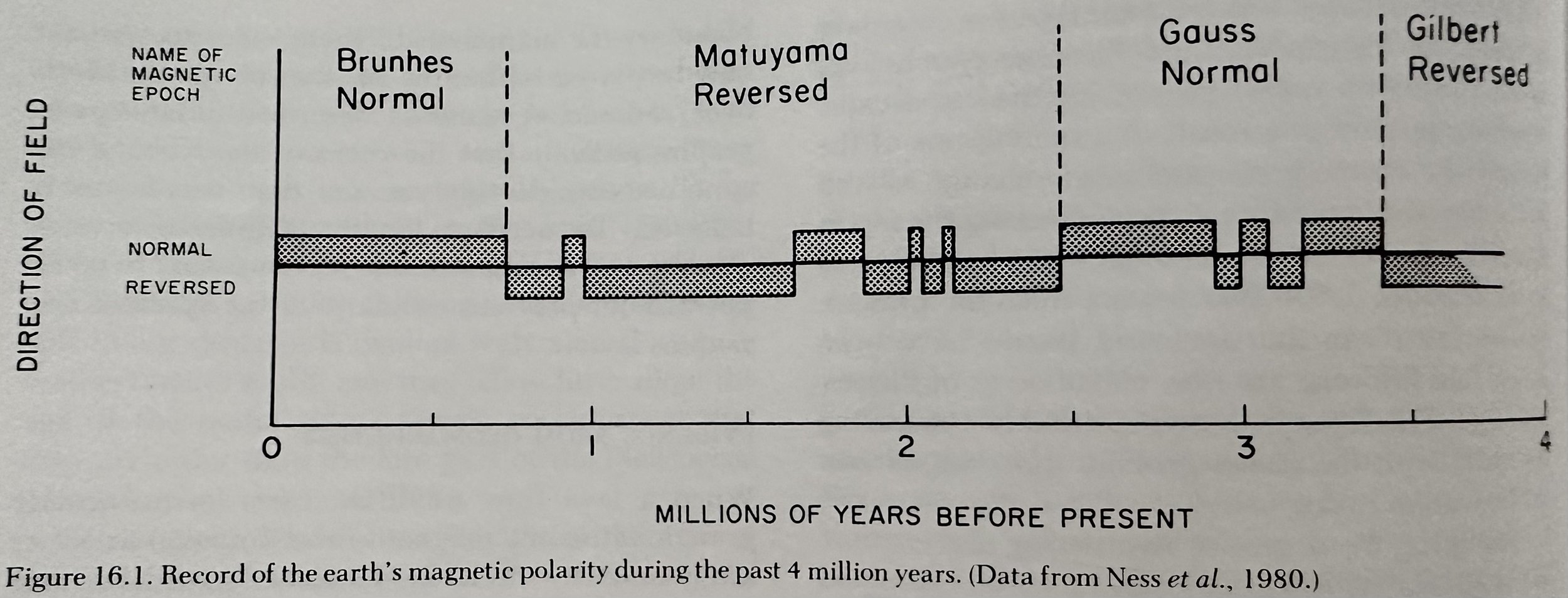
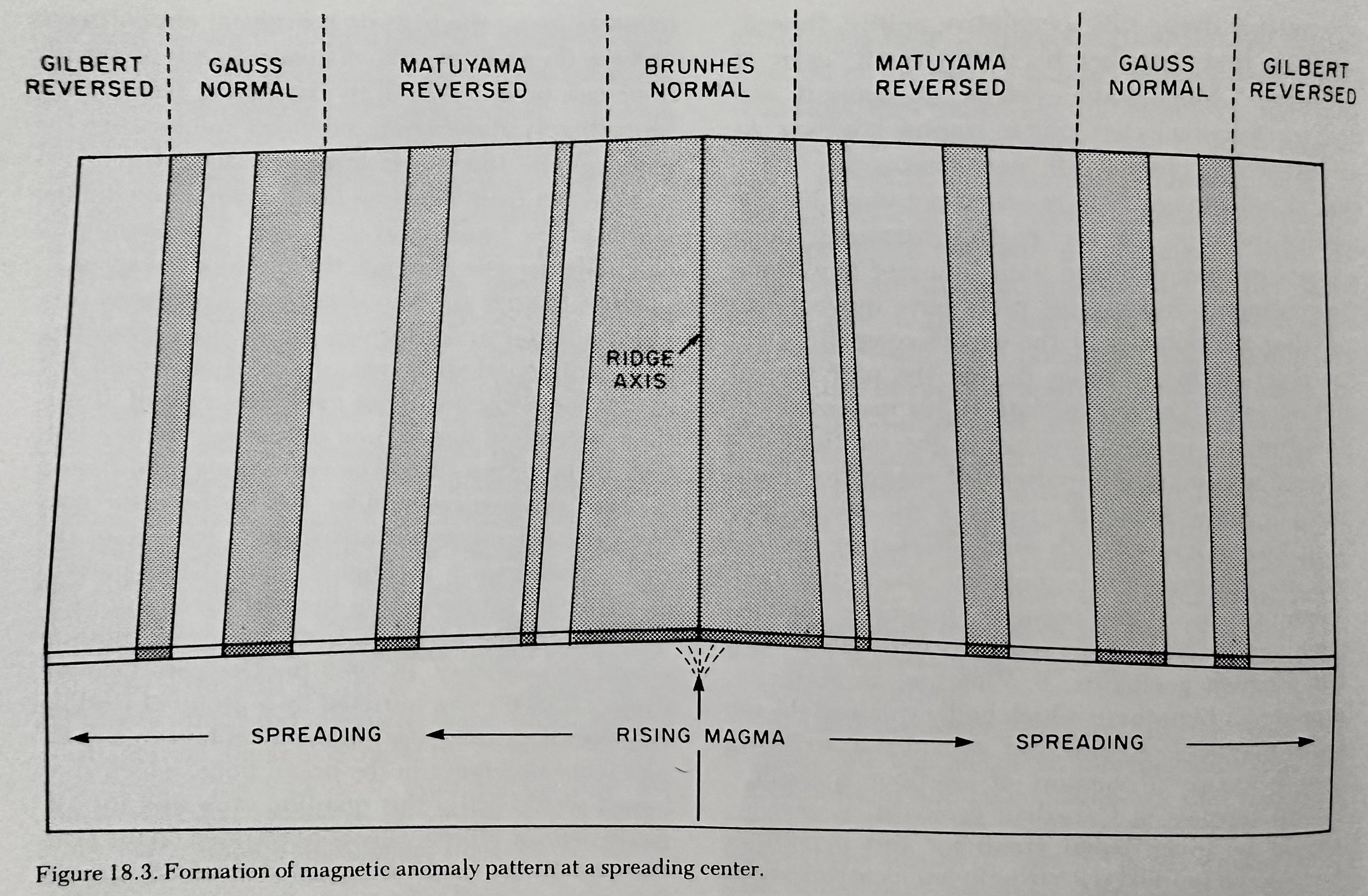
700ka- Present: Earth’s magnetic polarity is normal.-Volcanoes by MacDonald.
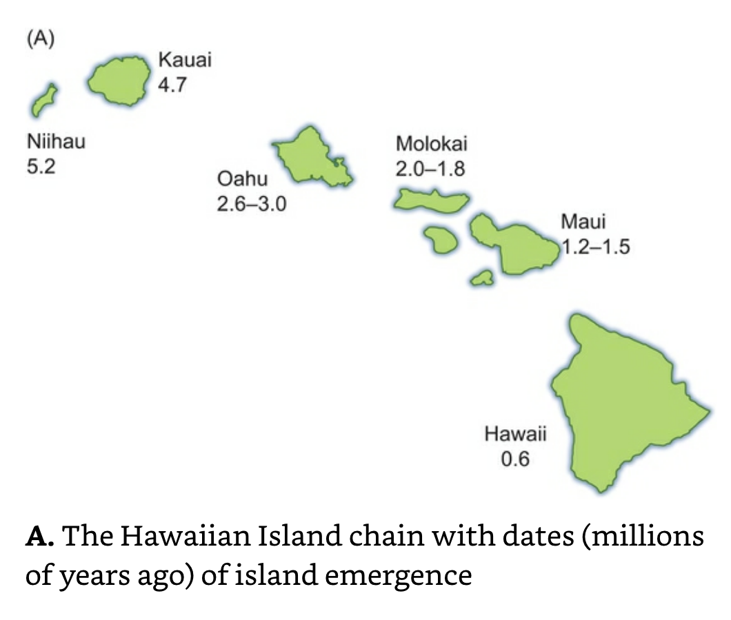
1ma: End of Volcanism of Oahu’s Koolau Volcano.-Volcanoes by MacDonald.
2ma: End of volcanism of Kauai’s volcano.-Volcanoes by MacDonald.
2.5ma- 700ka: Earth’s magnetic polarity is reversed.-Volcanoes by MacDonald.
3.4ma-2.5ma: Earth’s magnetic polarity is normal.-Volcanoes by MacDonald.
4ma: The Kauai Shield Volcano reaches its maximum height; erosion begins to dominate.-Volcanoes by MacDonald.
43ma: The Pacific Plate bends at the Hawaiian- Emperor Chain.-Volcanoes by MacDonald.
~60ma: A Flood Eruption vents 420km3 of basalt on the Columbia Plateau in the NW USA.-Volcanoes by MacDonald.
~500ma: A Flood Eruption occurs in what is now Michigan; creating the areas famous Copper deposits.-Volcanoes by MacDonald.
__________________________________________________________________________________