Essentials of Geology by Marshak
Ref: Stephen Marshak (2019). Essentials of Geology, 6th Edition.
___________________________________________________________________
Summary
Ideas of science come from observation, calculation, and experimentation by researchers. Science does not consist of subjective guesses or arbitrary dogmas, but rather of a consistent set of objective statements resulting from the application of the scientific method. Every scientific idea must be tested thoroughly and should be used only when supported by documented observations. Furthermore, scientific ideas do not appear out of nowhere; they are the result of human efforts.
Theories: Scientific ideas supported by an abundance of evidence; they have passed many tests and have failed none. Scientists are much more confident in the correctness of a theory than of a hypothesis.
You may notice that in everyday conversation, people commonly use the word theory as a synonym for an untested or barely tested speculation. In scientific discussion, the word has a much more restricted meaning.
Questions that we ask about the Universe differ little from questions a child asks of a new friend: Where do you come from? How old are you? Such musings first spawned legends in which heroes used supernatural powers to mold the planets and sculpt the landscape.
___________________________________________________________________
Ch 1: The Earth in Context
Stars
Star Formation: A protostar continues to grow, by pulling in successively more matter, until its core becomes so dense, and its temperature so high (about 10,000,000°C), that H nuclei within it move incredibly fast and slam together so forcefully that fusion takes place and new He nuclei form. Fusion reactions produce huge amounts of energy, so when they begin, the protostar “ignites” to becomes a nuclear furnace, and the ball becomes a true star.
Stellar Nucleosynthesis: Fusion of intermediate-weight elements by fusion reactions during the life cycle of stars, which creates elements not made during the Big Bang.
Supernova Nucleosynthesis: Most very heavy atoms form during the inconceivably hot conditions of a supernova explosion.
When the first generation of stars died, they left a legacy of new, heavier elements that mixed with residual hydrogen and helium from the Big Bang. A second generation of stars and associated planets formed out of these compositionally more diverse nebulae. When these stars died, they contributed heavier elements to third-generation stars. Succeeding generations contain a progressively greater proportion of heavier elements.
Formation of the Solar System
Nebular Theory of Planet Formation: The concept that planets grow out of rings of gas, dust, and ice surrounding a newborn star. The material of the surrounding rings began to clump and bind together, due to gravity and electrical attraction, forming a series of concentric rings around the proto-Sun. In these rings, matter was denser, and particles got close enough to each other to attract. First, soot-sized particles merged to form sand-sized grains. These then stuck together to form grainy basketball-sized blocks, which in turn collided. Eventually, enough blocks coalesced to form planetesimals, bodies whose diameter exceeded about 1 km. Because of their mass, the planetesimals exerted enough gravitational attraction to pull in other objects that were nearby. Planetesimals behaved like vacuum cleaners, sucking in small pieces of dust and ice as well as smaller planetesimals that lay in their orbit, and in the process, they grew progressively larger. Eventually, victors in the competition to attract mass grew into protoplanets, bodies approaching the size of today’s planets. Once a protoplanet succeeded in incorporating virtually all the debris within its orbit, it became a full-fledged planet.
Planetary Heat: The heat came primarily from three sources: the heat produced during collisions (similar to the heat produced when you bang on a nail with a hammer and they both get warm); the heat produced when matter squeezed into a smaller volume (see Box 1.2); and the heat produced from the decay of radioactive elements.
Differentiation (Planetary): A process early in a planet’s history during which dense Fe alloy melt and sink downward to form the core, leaving less-dense mantle behind.
Earth System: The global interconnecting web of physical and biological phenomena involving the solid Earth, the hydrosphere, and the atmosphere.
Internal Process: A process in the Earth System, such as plate motion, mountain building, or volcanism, ultimately caused by the Earth’s internal heat.
External Process: A geomorphologic process—such as downslope movement, erosion, or deposition—that is the consequence of gravity or of the interaction between the solid Earth and its fluid envelope (air and water). Energy for these processes comes from gravity and sunlight.
Magnetosphere: The region protected from the electrically charged particles of the solar winds by the Earth’s magnetic field.
Atmosphere: A layer of gases that surrounds a planet.
Atmosphere (atm): Has a value of 1.03 kg per sqcm (14.7 PSI), which represents the average air pressure at sea level.
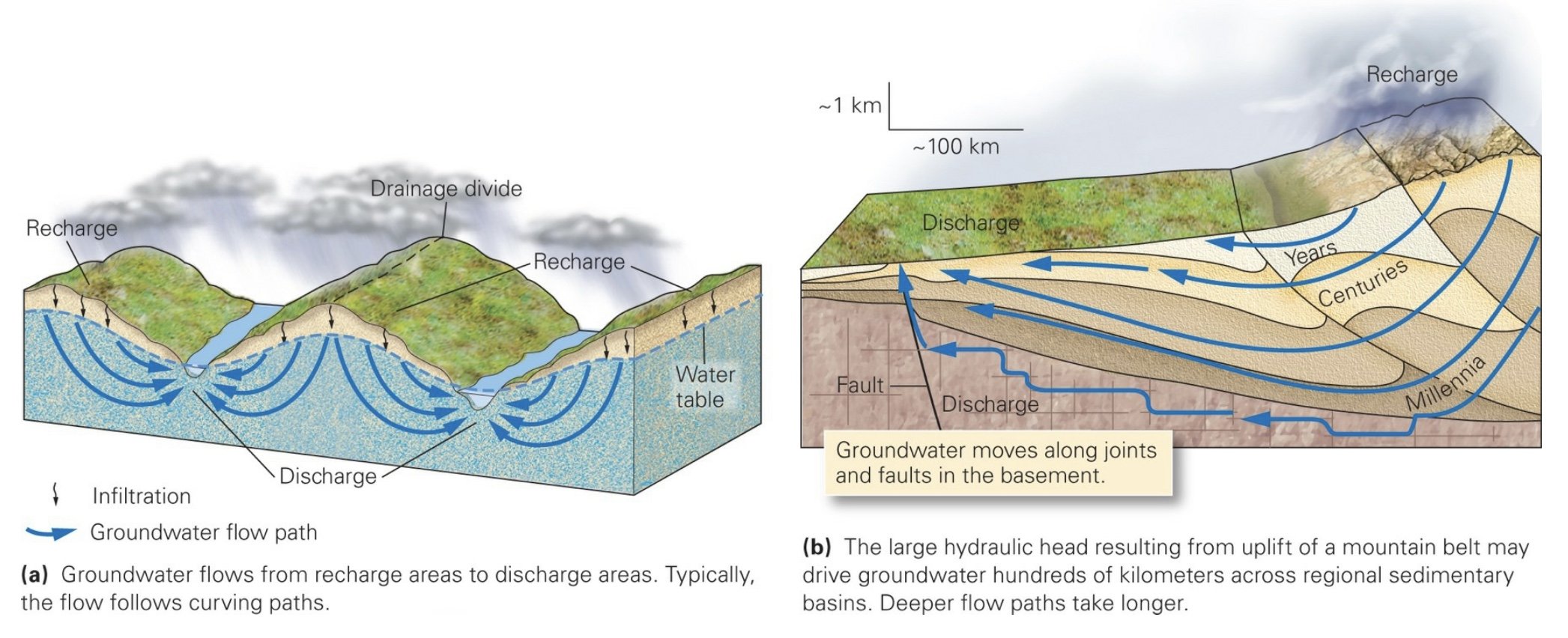
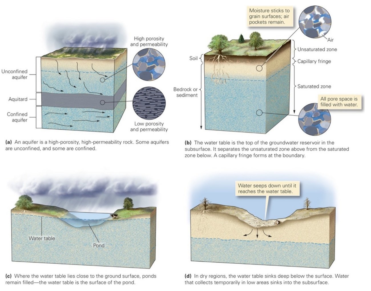
Hydrosphere: The Earth’s water, including surface water (lakes, rivers, and oceans), groundwater, and liquid water in the atmosphere.
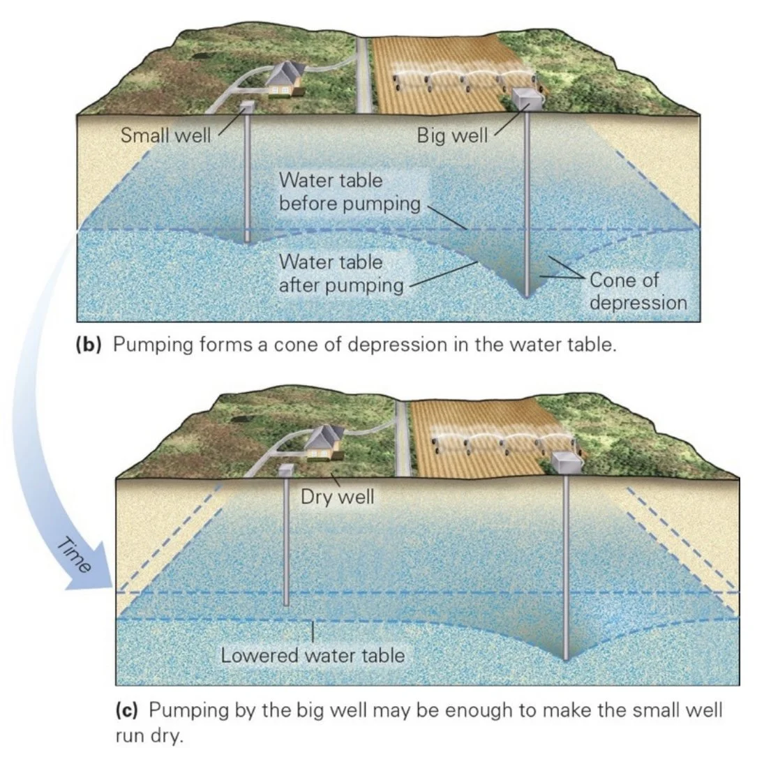
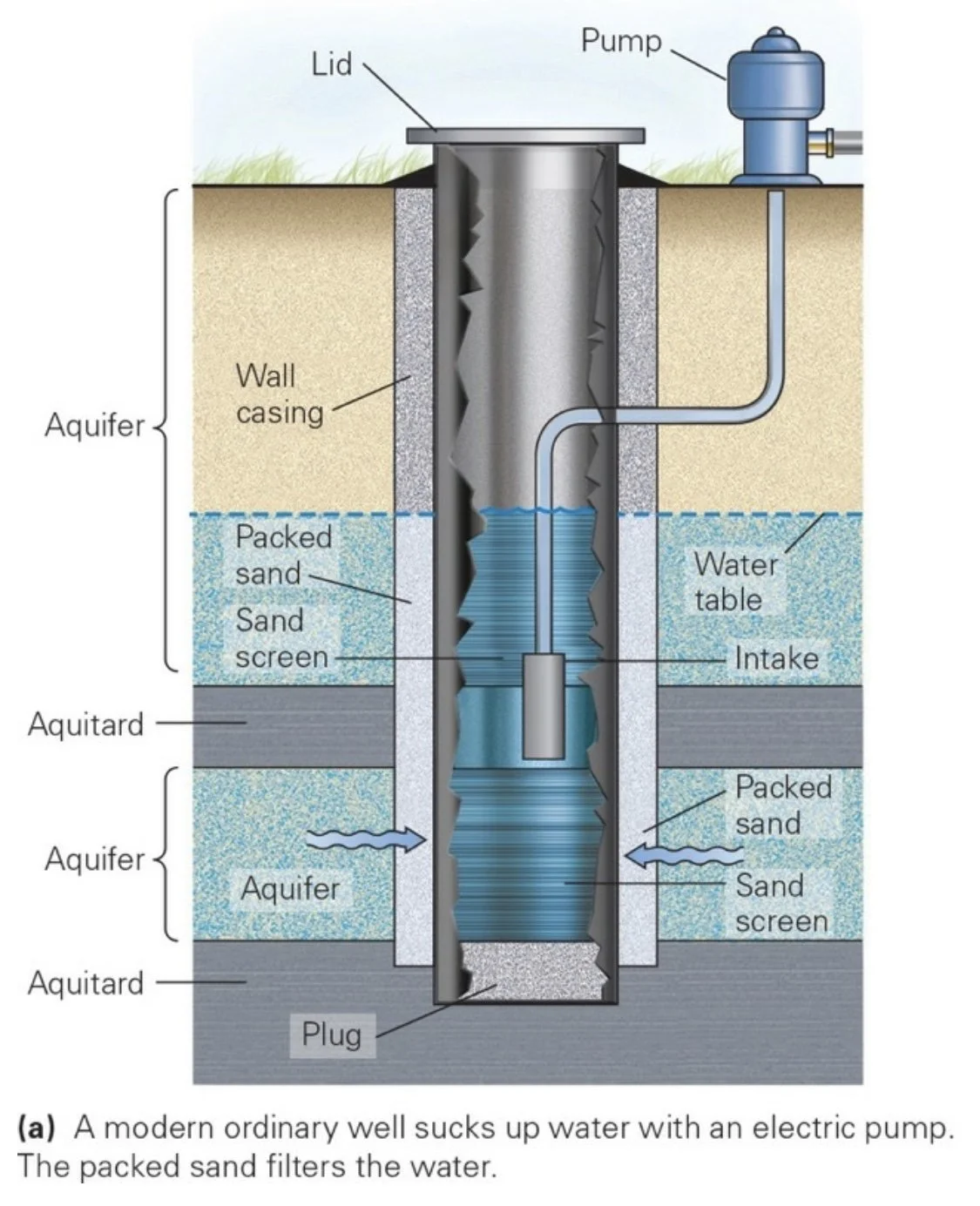
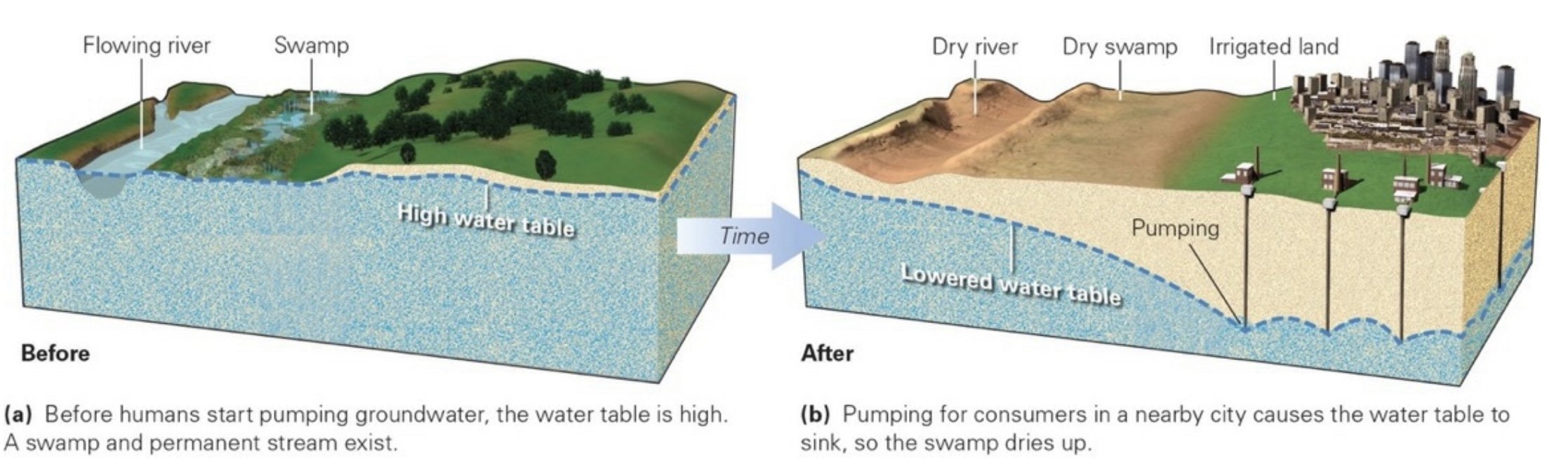
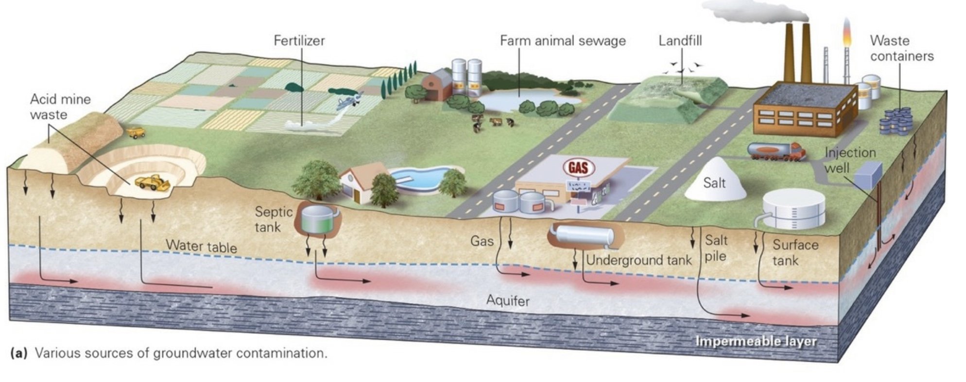
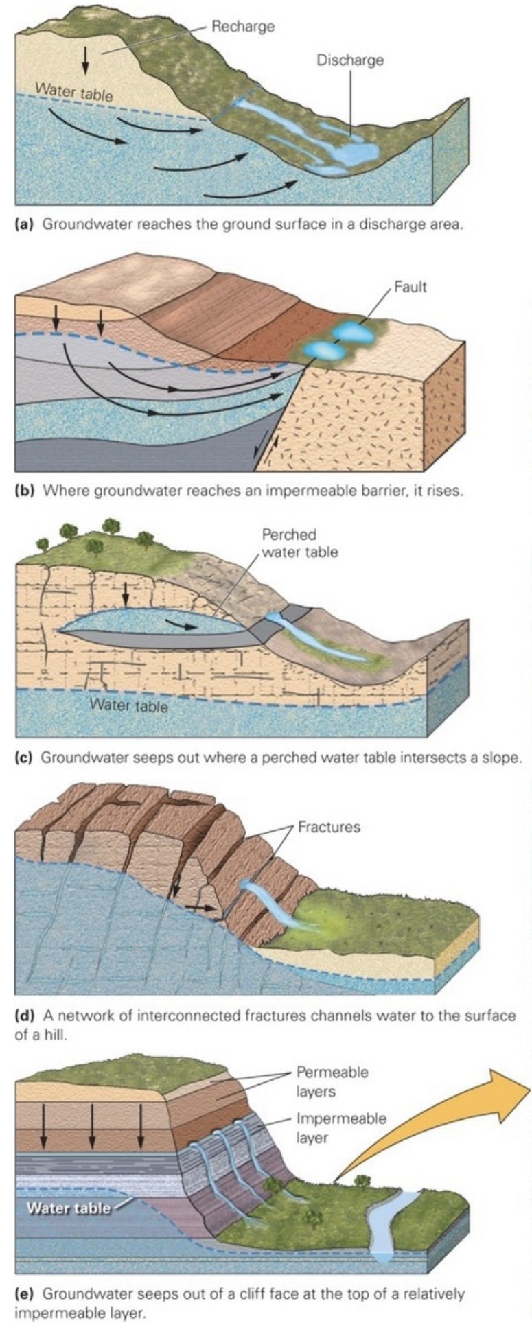
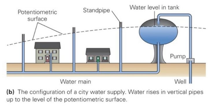
Groundwater: Water that resides under the surface of the Earth, mostly in pores or cracks of rock or sediment
Cryosphere: The realm of the Earth System that consists of frozen water (ice); it includes glaciers, sea ice, and permafrost.
Biosphere: The region of the Earth and atmosphere inhabited by life; this region stretches from a few km below the Earth’s surface to a few km above.
Geosphere: The solid part of the Earth from the surface to the center.
Objects from Space
Meteoroid: Any object that enters the Earth’s atmosphere from space. Meteoroids move at speeds of 20 to 75 km/s per second when they reach an altitude of 150 km. Below this altitude, compression of the air in front of a meteoroid makes the air hot enough to melt and vaporize the meteoroid’s surface. This process produces a streak of bright, glowing gas in the meteoroid’s wake. The glowing streak, an atmospheric phenomenon, is a meteor, also known, commonly though incorrectly, as a falling star. Most visible meteors completely vaporize by an altitude of about 30 km. But dust-sized ones may slow down sufficiently to float to Earth, and some that are fist-sized or bigger can survive the heat of entry to reach the surface of the planet.
Meteorites: Objects that strike the Earth with three basic classes; 93% are stony and 6% iron.
Iron: Comprised of iron-nickel alloy.
Stony: Comprised of rock.
Stony Iron: Rock embedded in a matrix of metal.
___________________________________________________________________
Ch 2: Plate Tectonics
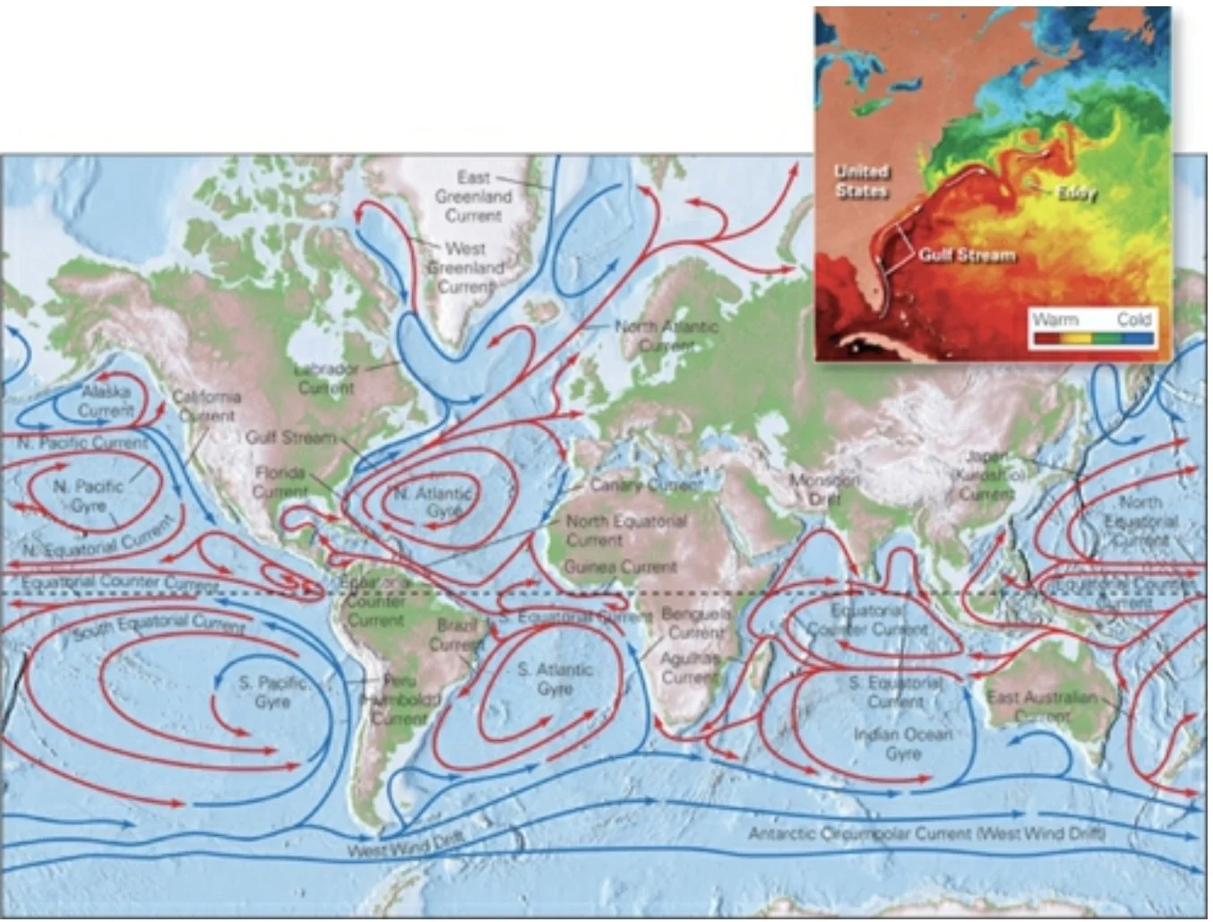
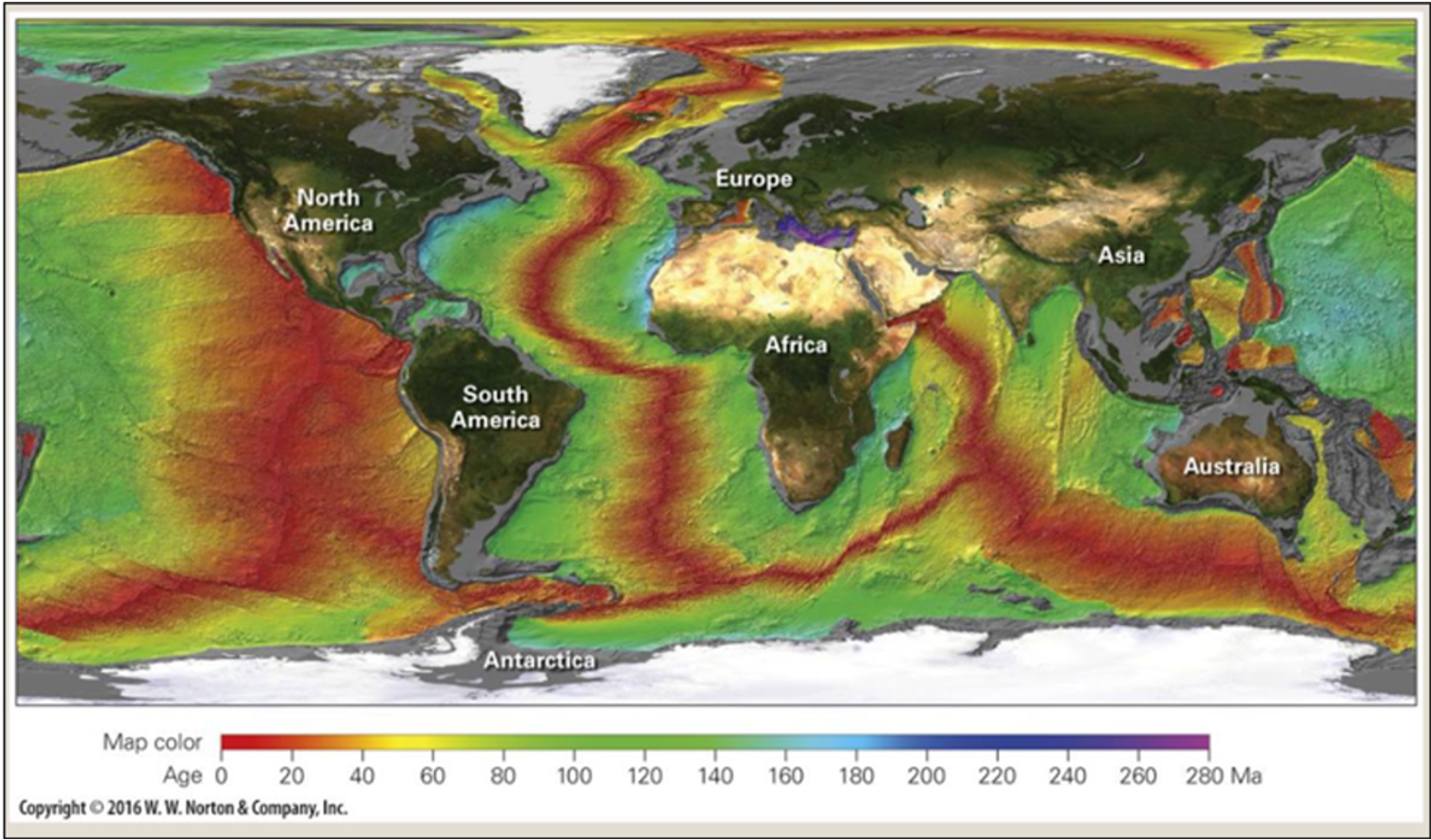
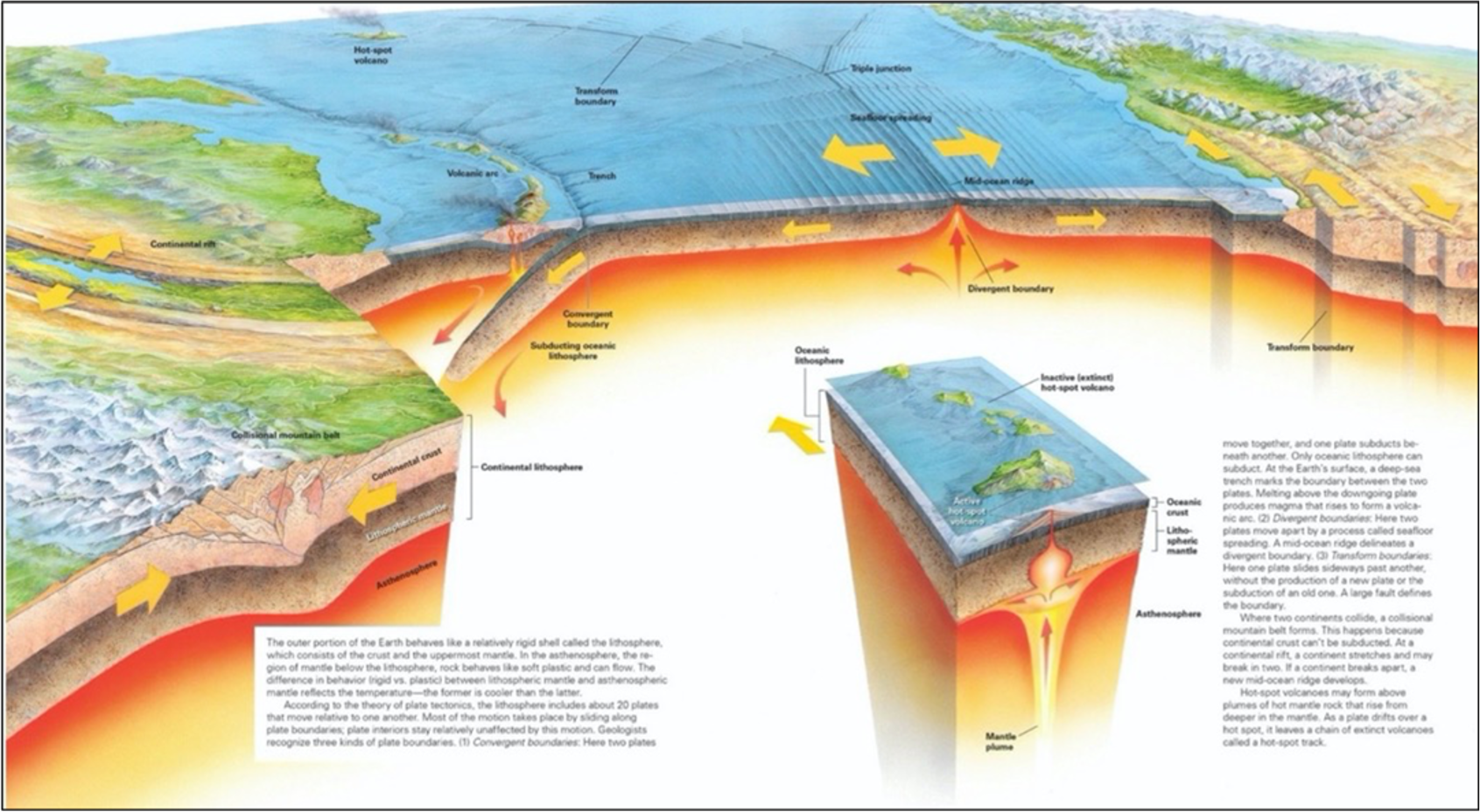
Theory of Plate Tectonics: The grand unifying theory of geology; the outer layer of the Earth (the lithosphere) consists of separate plates that move with respect to one another.
Alfred Wegener: Discerned that all late Paleozoic glaciated areas lie adjacent to each other on his map of Pangaea. Furthermore, when he plotted the orientation of glacial striations, they all pointed roughly outward from a location in southeastern Africa. Wegener argued that the continents had once been connected in a supercontinent, Pangaea, that later broke up to produce smaller continents that drifted apart. He showed that the matching shapes of coastlines, as well as the distribution of ancient glaciers, climate belts, fossils, and rock units, make better sense if Pangaea existed. But Wegener couldn’t convince his peers about continental drift.
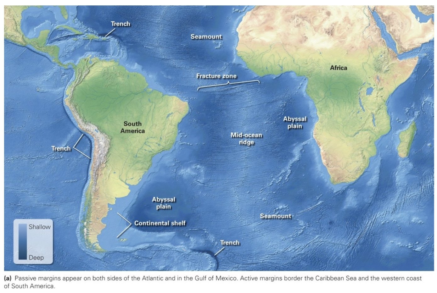
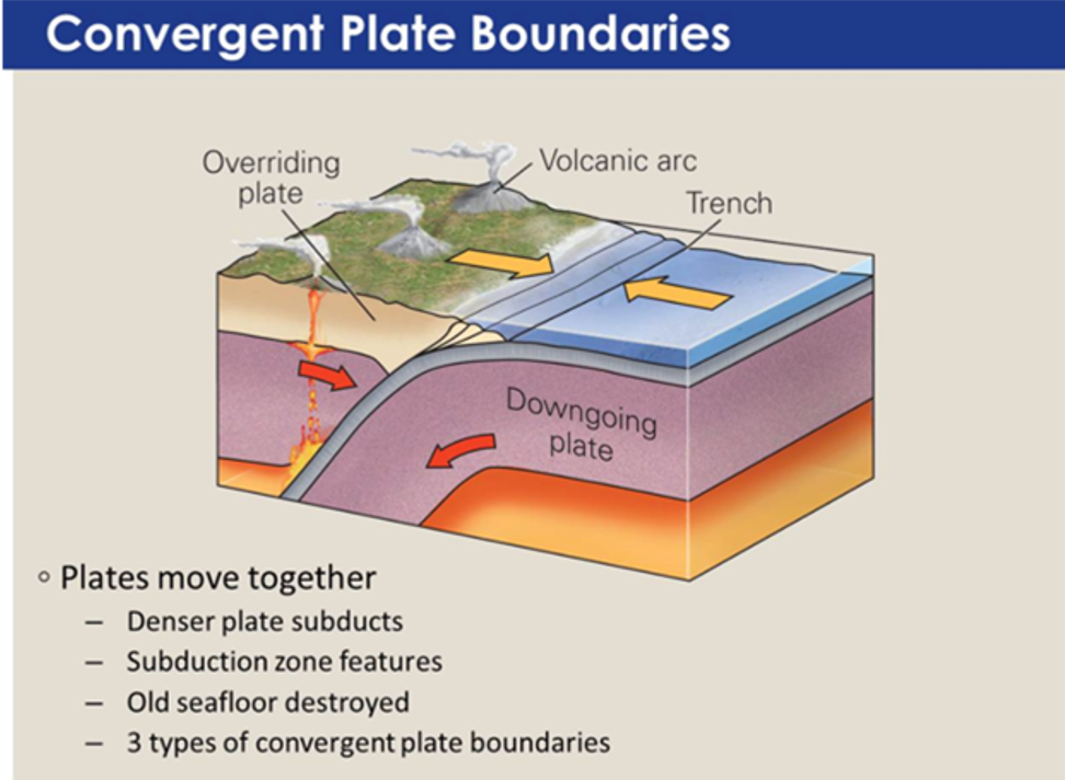
Convergent Plate Boundaries
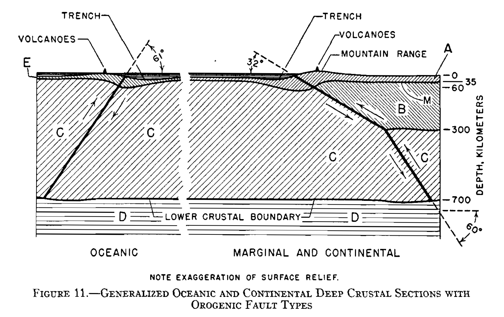
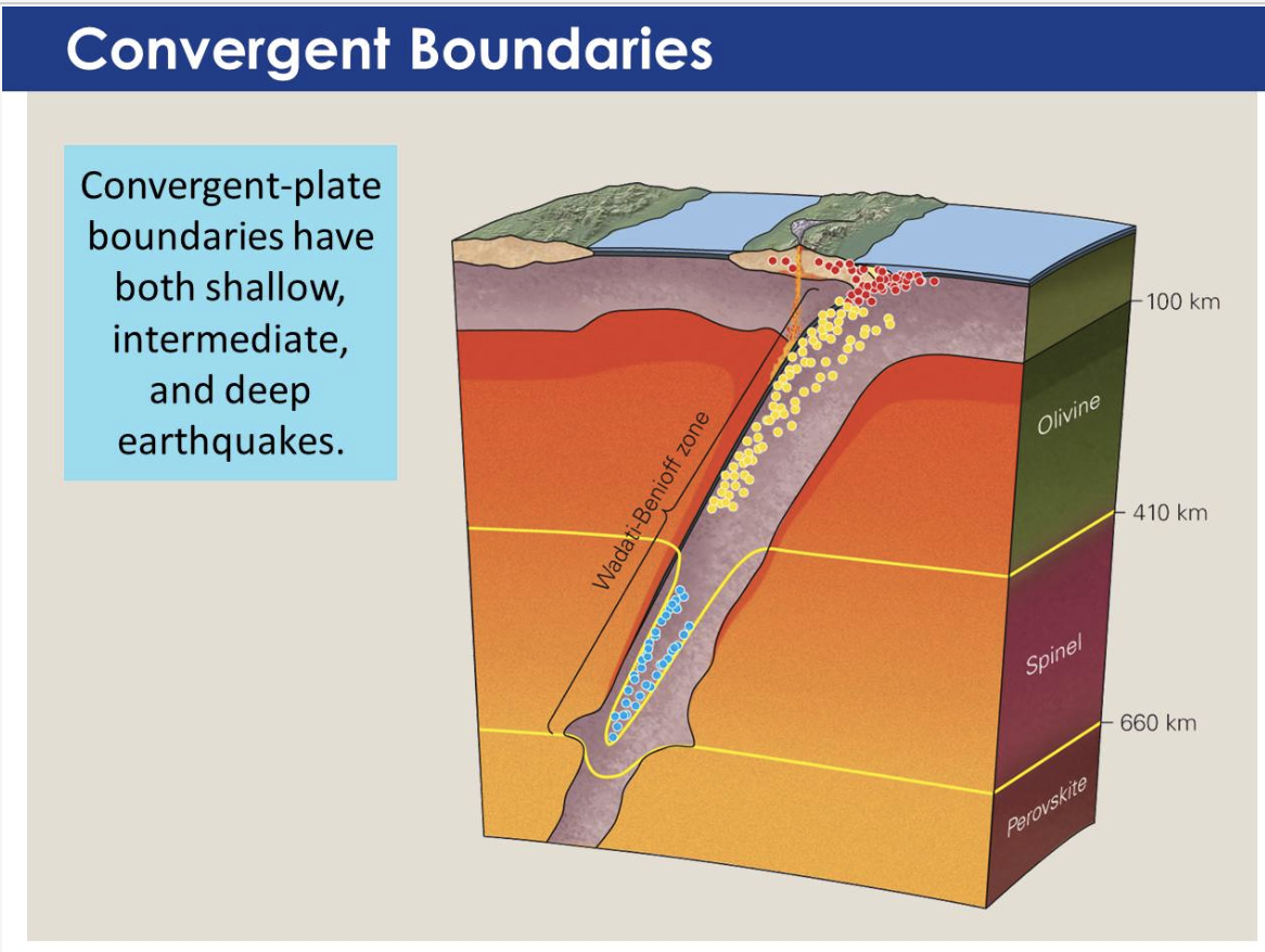
Wadati-Benioff Zone: The band of earthquakes in a downgoing plate.
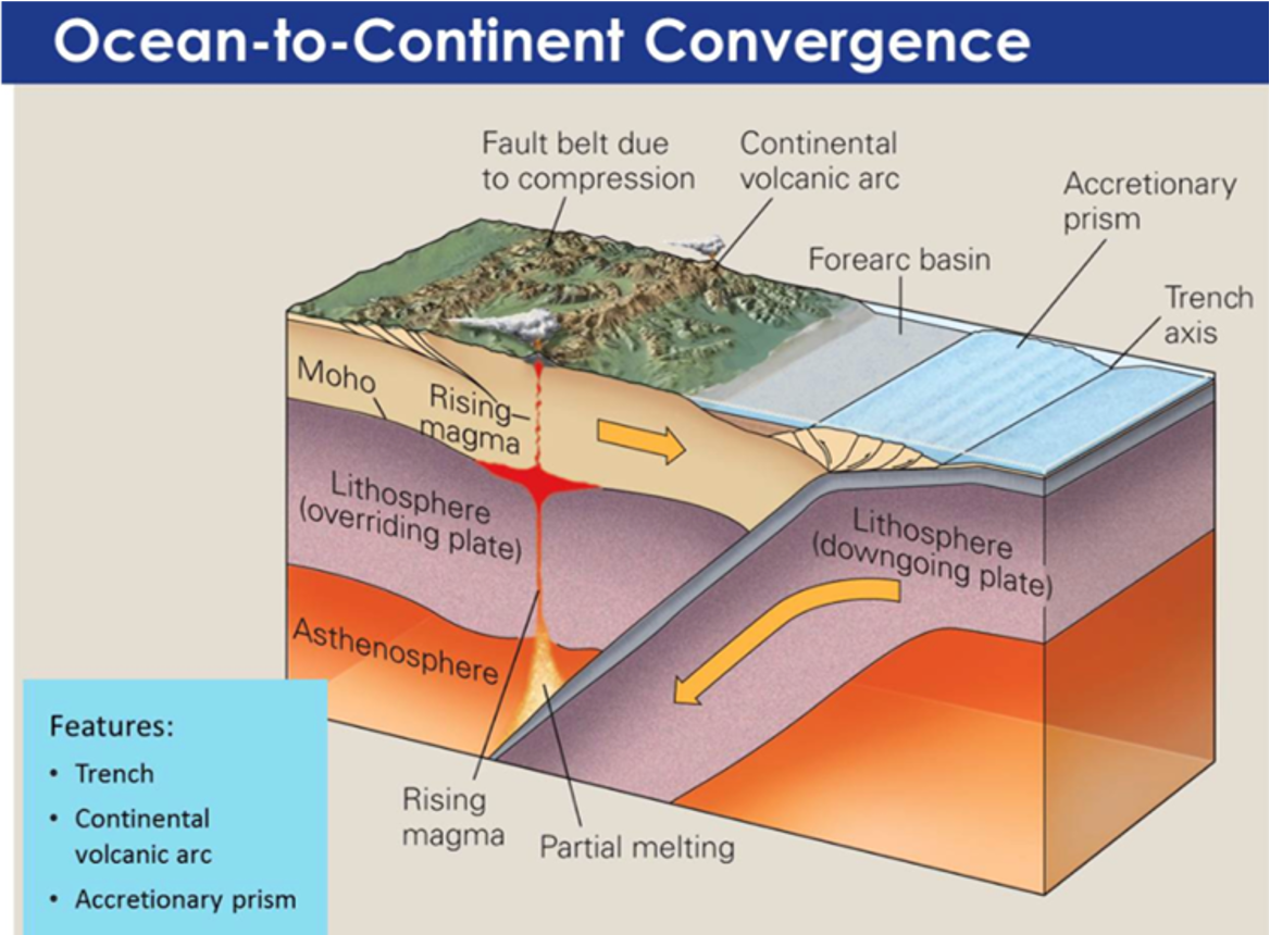
Volcanic Arc: A chain of volcanoes that develops on the edge of the overriding plate behind the accretionary prism. The magma that feeds these volcanoes forms just above the surface of the downgoing plate where the plate reaches a depth of about 150 km below the Earth’s surface.
Accretionary Prism: A wedge-shaped mass of sediment and rock scraped off the top of a downgoing plate and accreted onto the overriding plate at a convergent plate margin.
Triple Junction: Where three plate boundaries intersect.
Slab-Pull Force: The force that downgoing plates (or slabs) apply to oceanic lithosphere at a convergent margin.
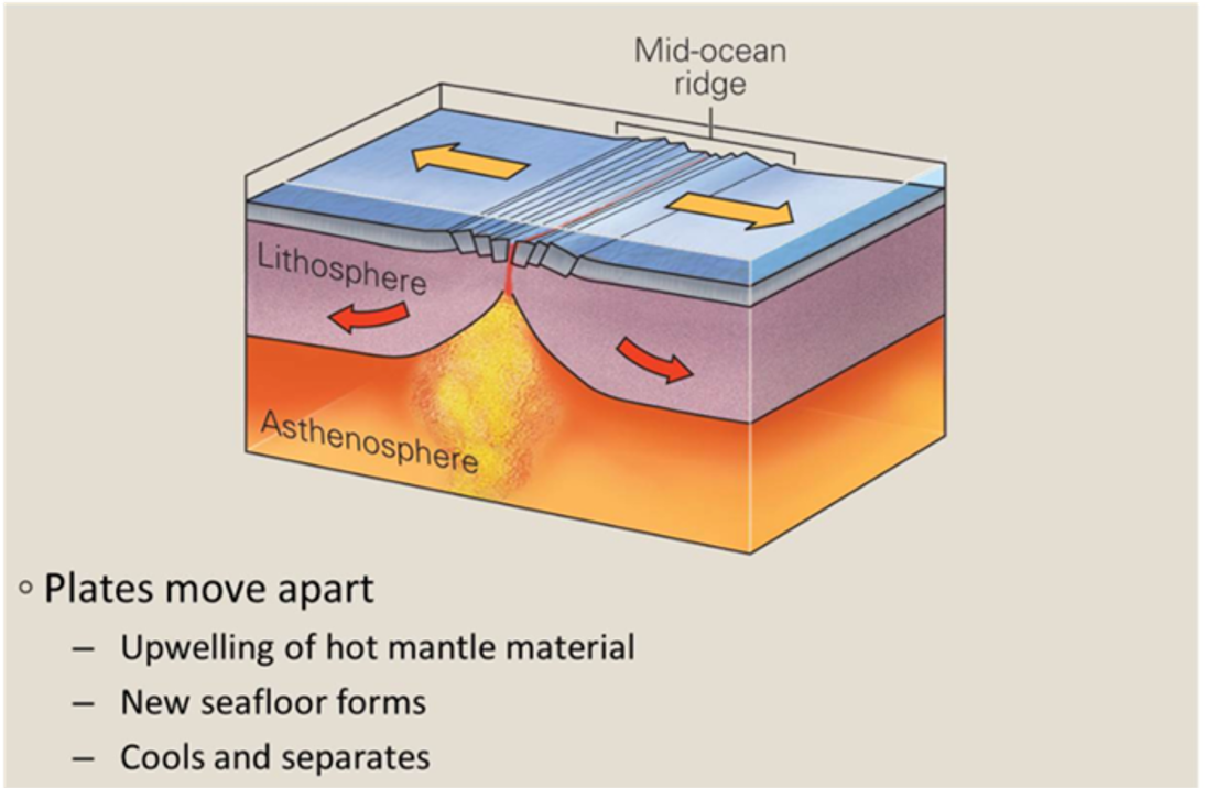
Divergent Plate Boundaries: Most form when a continent splits and separates into two continents (rifting).
Ridge-Push Force: A process in which gravity causes the elevated lithosphere at a mid-ocean ridge axis to push on the lithosphere that lies farther from the axis, making it move away.
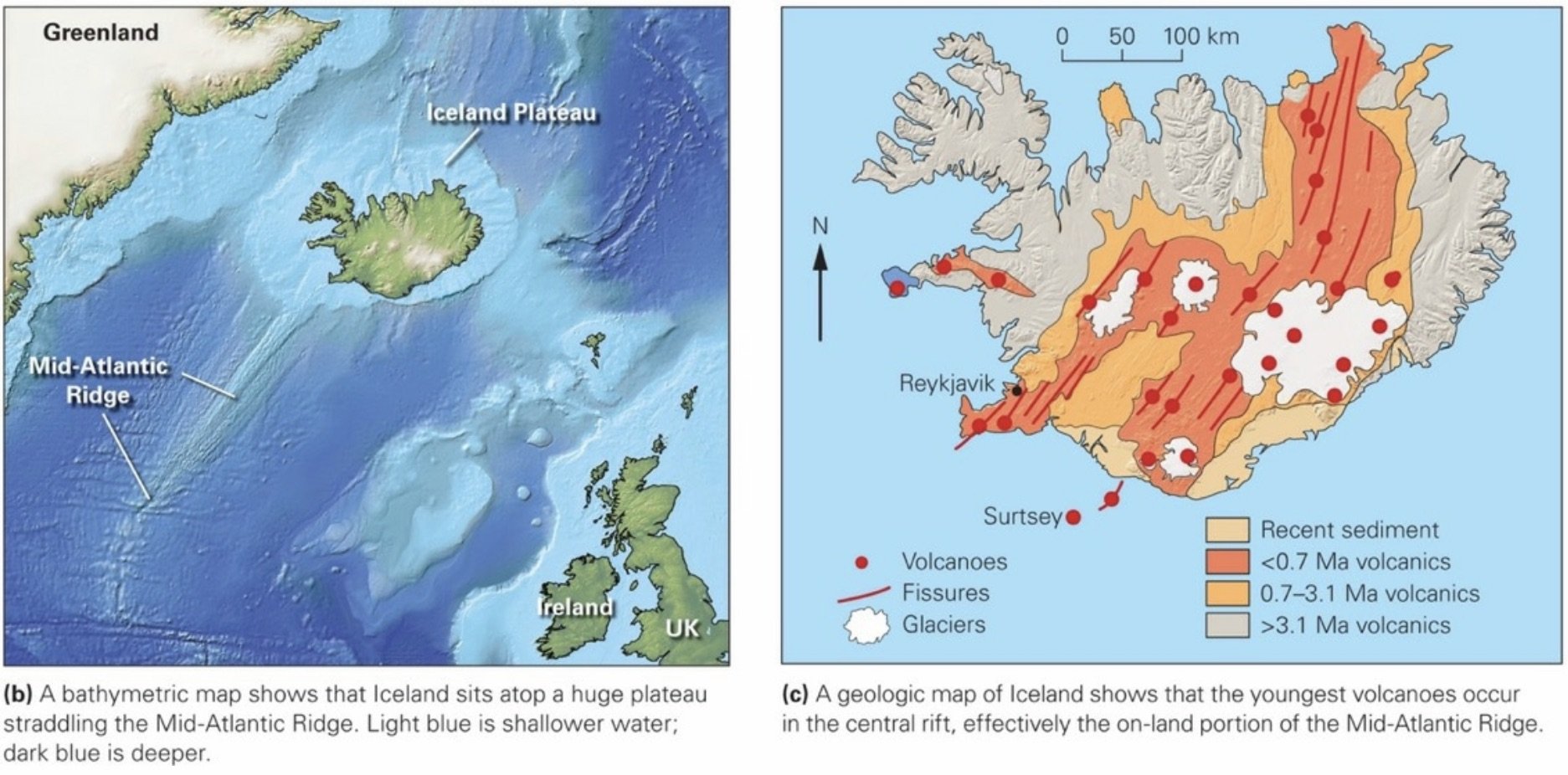
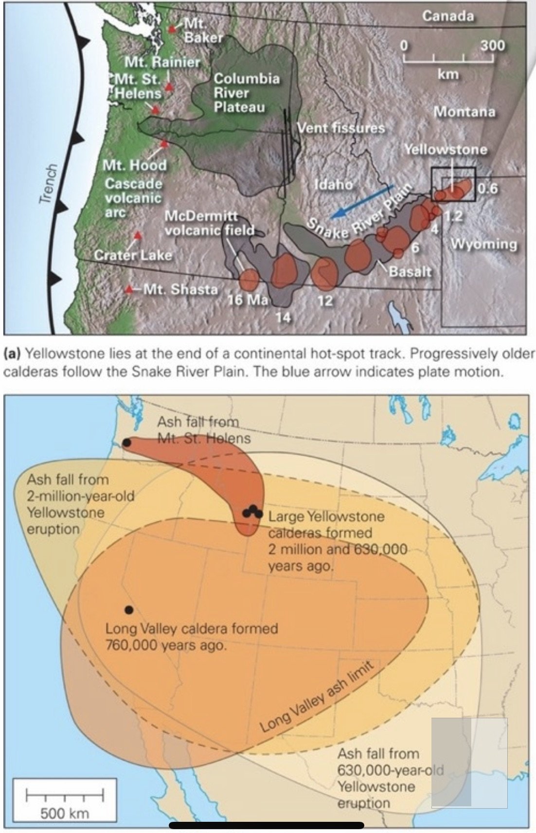
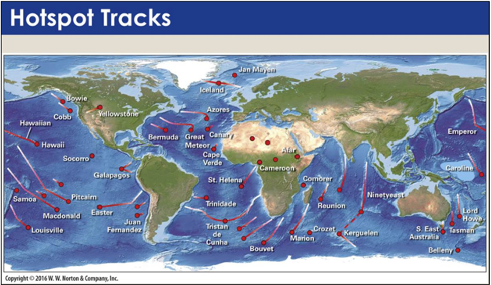
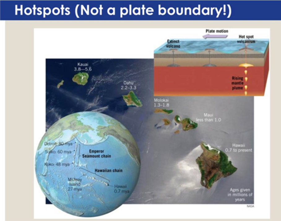
Hot Spots: The heat source for hot spots is a mantle plume, a column of very hot rock rising up through the mantle to the base of the lithosphere.
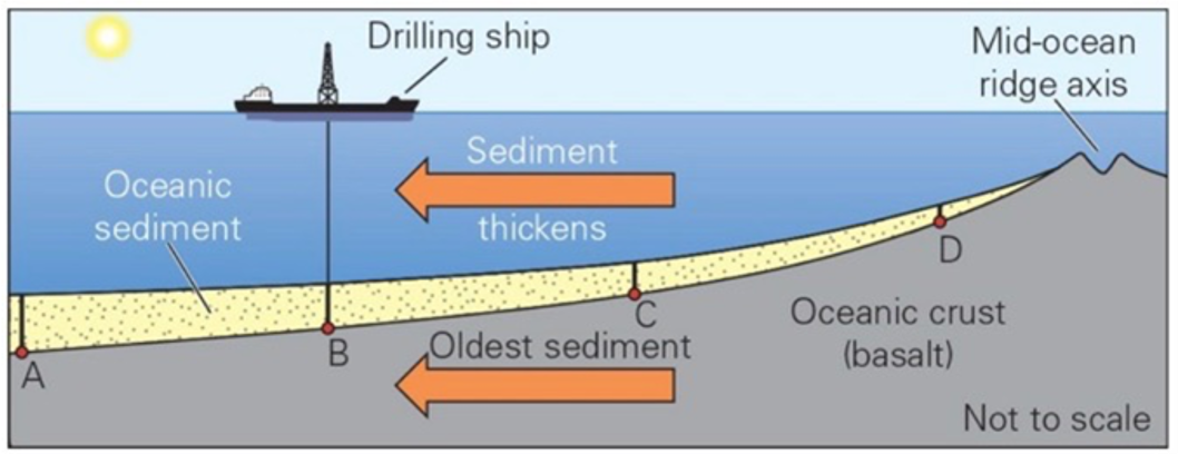
Rate of Plate Movements: ~1- 15 cm per year—about the rate that your fingernails grow.
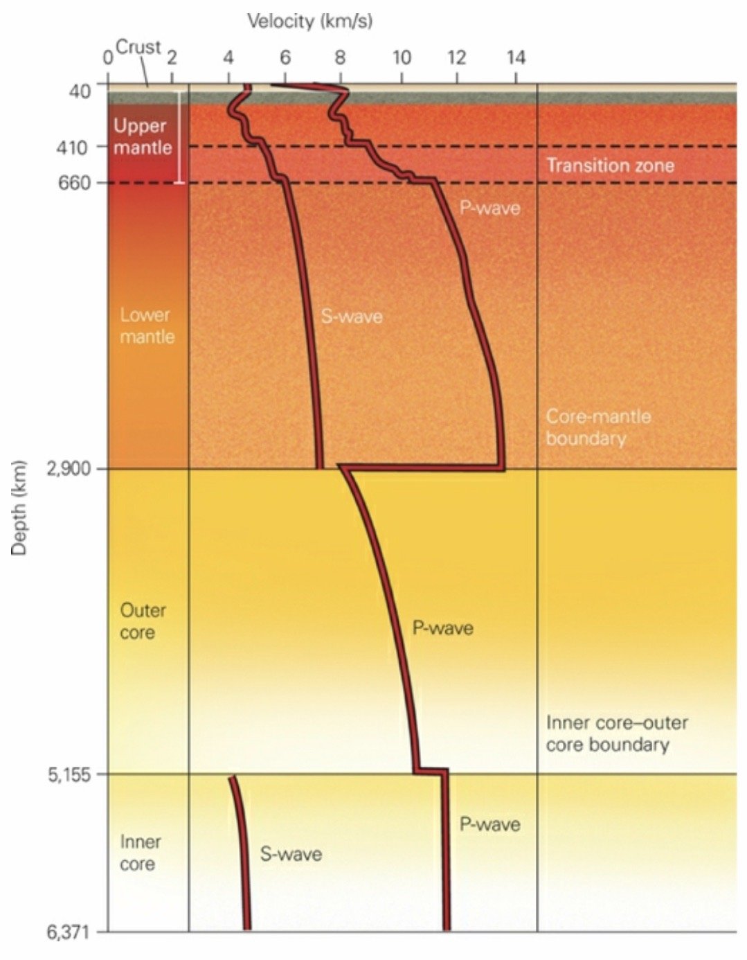
Earth’s Layers
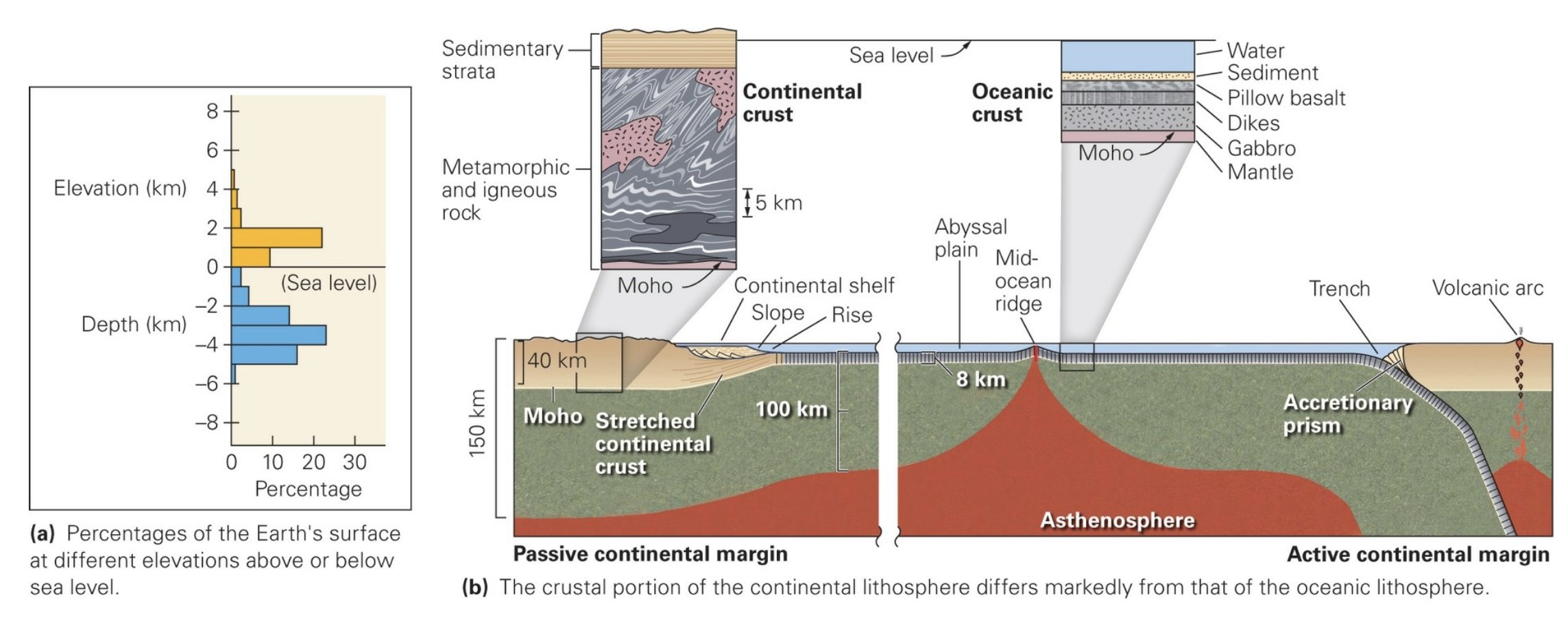
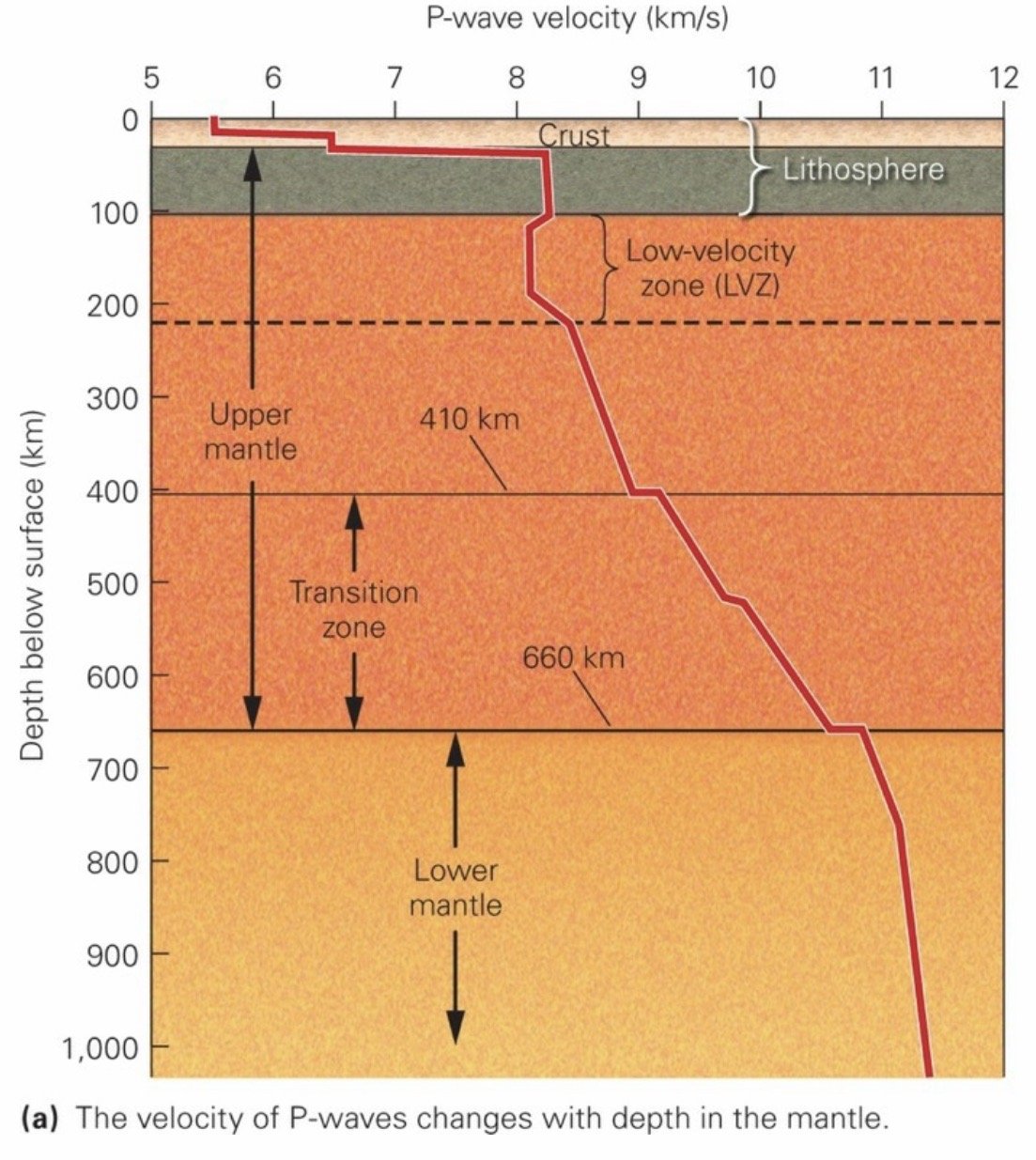
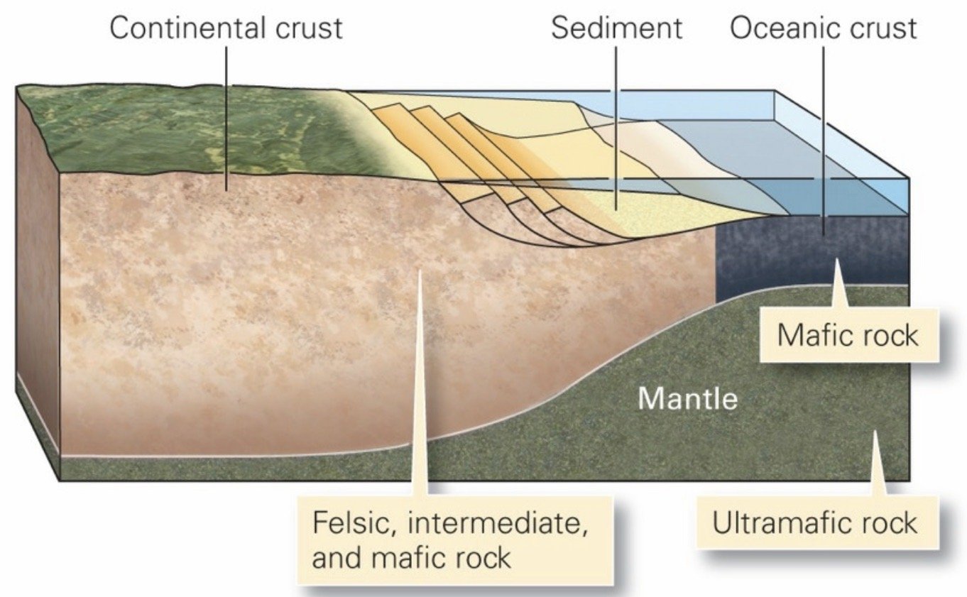
Lithosphere: The outermost layer of the earth’s crust constituting the crust and the top part of the mantal; on average continental lithosphere has a thickness of 150 km, whereas old oceanic lithosphere has a thickness of about 100 km. The crustal part of continental lithosphere ranges from 25 to 70 km thick and consists largely of relatively low-density felsic and intermediate rock (granite). In contrast, the crustal part of oceanic lithosphere is only 7 to 10 km thick and consists of relatively dense mafic rock (basalt and gabbro).
Crust: Varies in thickness from 7-10 km (beneath the oceans) to 25-70 km (beneath the continents).
In the upper part of the crust, the geothermal gradient averages between 20°C and 30°C per km. At greater depths, the gradient decreases, so that 35 km below the surface of a continent, the temperature reaches 400°C to 700°C, and at the mantle-core boundary it is about 3,500°C.
As soon as mantle rock (peridotite) cools below 1,280°C, it becomes, by definition, part of the lithosphere.
Mantle: Part of both continental and oceanic lithosphere consists of very dense ultramafic rock (peridotite).
Transition Zone: The lower part of the upper mantle, between 410-660 km deep. In this zone, seismic-wave velocities increase in a series of steps due to abrupt changes in the character of minerals making up mantle rock.
Asthenosphere: Portion of the mantle in which rock behaves like soft plastic and can flow. The boundary between the lithosphere and asthenosphere occurs where the temperature reaches about 1,280°C, for when temperatures are higher than this value, mantle rock becomes soft enough to flow.
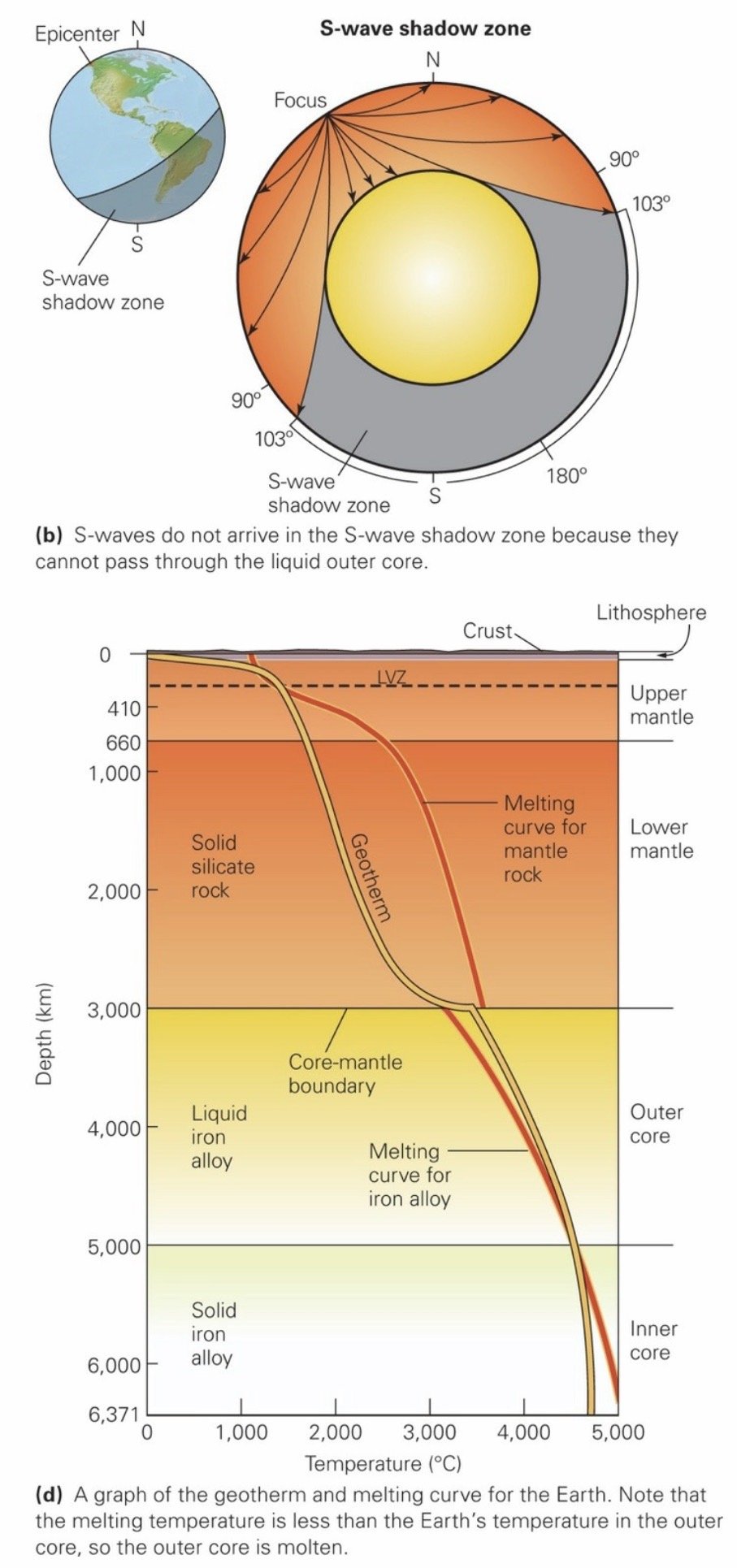
Core: Even though it is hotter than the outer core, the inner core’s alloy remains solid because it endures even greater pressure, enough to keep atoms locked together tightly in solid crystals.
The core-mantle boundary, lies at a depth of about 2,900 km.
Mohorovičić (Moho): The crust-mantle boundary.
___________________________________________________________________
Ch 3: Patterns in Nature: Minerals
Mineral: A homogenous, naturally occurring, solid inorganic substance with a definable chemical composition and an internal structure characterized by an orderly arrangement of atoms, ions, or molecules in a lattice. Most minerals are inorganic and form by solidification of a melt, by precipitation from a water solution or a gas, or by rearrangement of atoms in a solid. Mineralogists distinguish several principal classes of minerals. Minerals can form by solidification of a melt, by precipitation from a water solution or a gas, or by rearrangement of atoms in a solid.
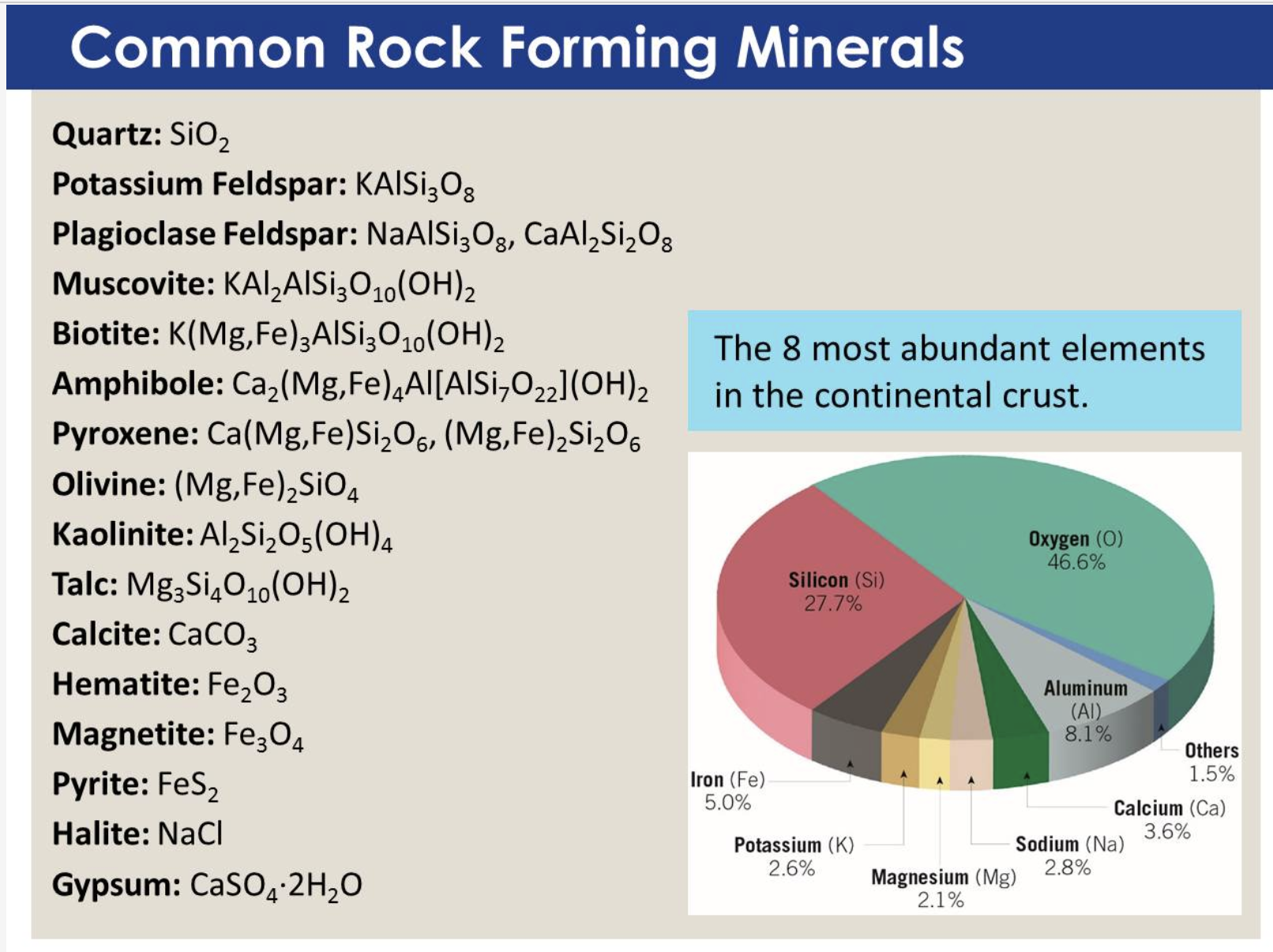
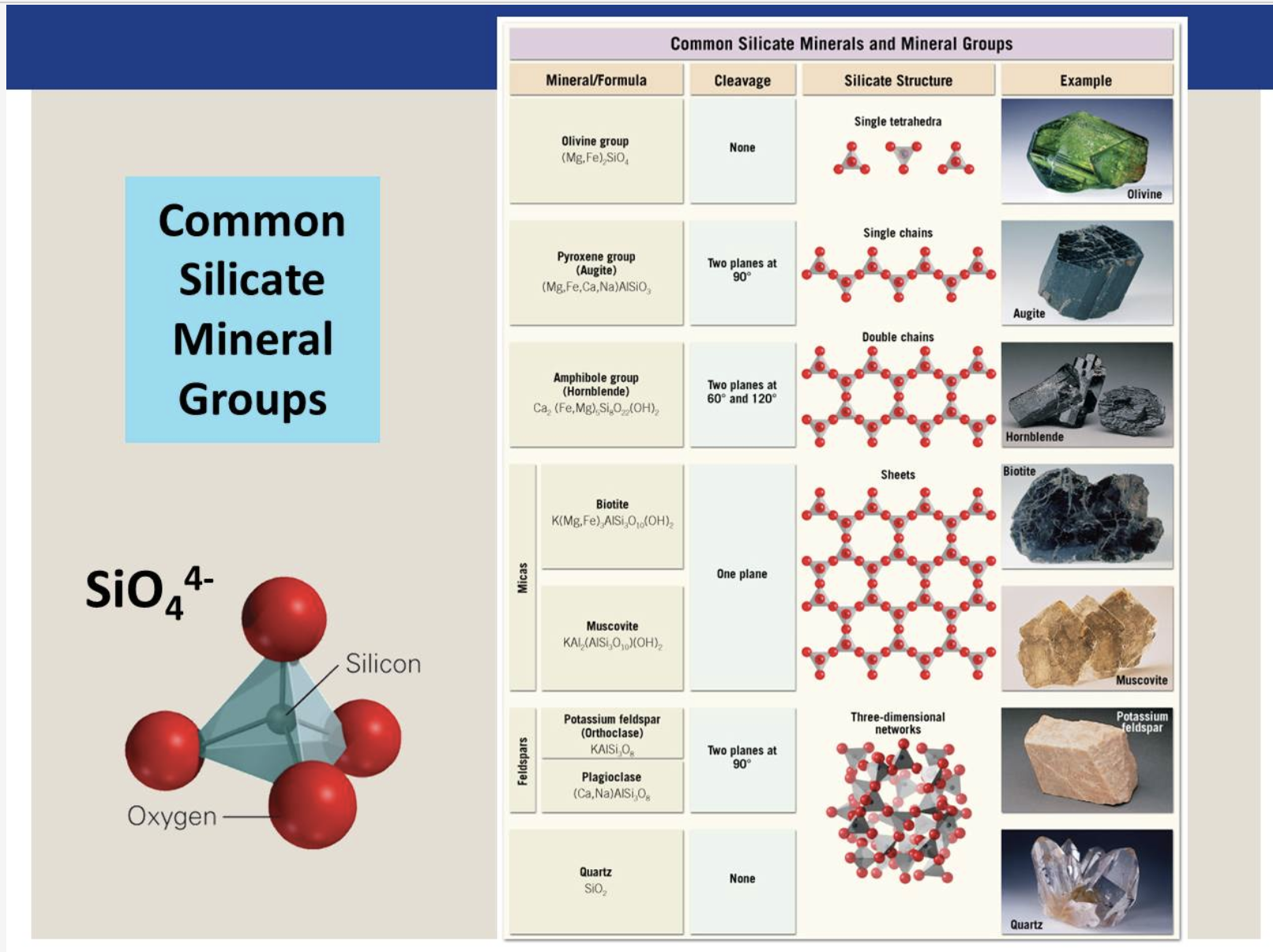
Silicates: The most common minerals on Earth. The fundamental component of most silicates in the Earth’s crust is the SiO4– anionic group. In this group, four oxygen atoms surround a single silicon atom. Groups of silicate minerals are distinguished from each other by the ways in which the silicon-oxygen tetrahedra that constitute them are linked.
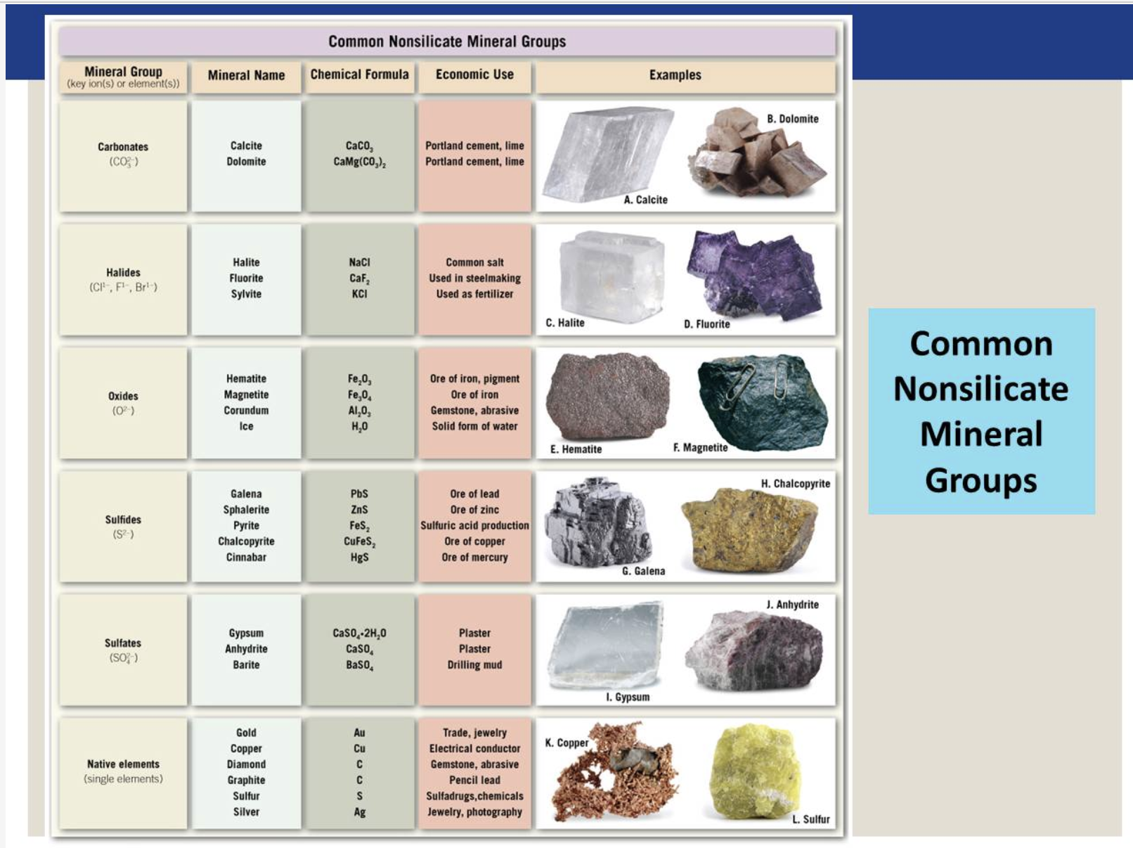
Sulfides: Consist of a metal cation bonded to a sulfide anion (S2–).
Oxides: Consist of metal cations bonded to oxygen anions.
Halides: The anion in a halide is a halogen ion (such as chloride [Cl–] or fluoride [F–]).
Carbonates: CO2– serves as the anionic group. Elements such as calcium or magnesium bond to this group.
Native Metals: Consist of pure masses of a single metal. The metal atoms are bonded by metallic bonds.
Sulfates: Consist of a metal cation bonded to the SO2– anionic group. Many sulfates form by precipitation out of water at or near the Earth’s surface.
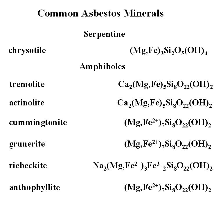
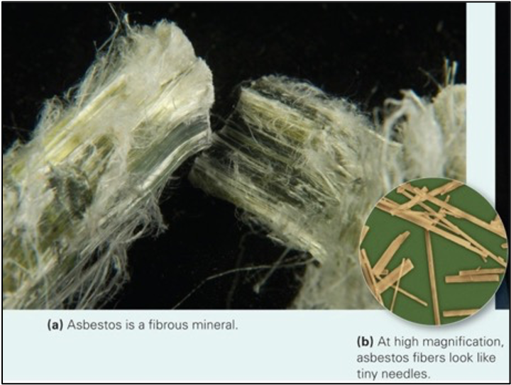
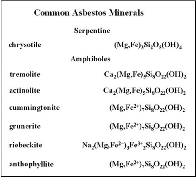
Asbestos (Minerals): Contain a fibrous crystal habit. Thus, samples of asbestos consist of clusters of needle-like crystals. For years, asbestos has been incorporated into floor tiles, roof shingles, brake pads, fireproof clothes, and insulation. Its popularity derived from the fact that because it’s a mineral, it doesn’t burn, and because it’s fibrous, it can be woven into other materials. Its presence in other materials adds strength because fibers have strong bonds along their length. When intact, asbestos-bearing materials are not especially hazardous. But in the form of dust, during mining, or during construction or demolition, the fibers can be dangerous to human health. If inhaled, they lodge in the lungs where they cause irritation and may trigger cancer.
Mineral Properties
Color: Results from the presence of impurities.
Streak: The color of a powder produced by pulverizing the mineral. You can obtain a streak by scraping the mineral against an unglazed ceramic plate
Luster: The way a mineral surface scatters light. Minerals that look like metal have a metallic luster, whereas those that do not have a nonmetallic luster (silky, glassy, satiny, resinous, pearly, or earthy).
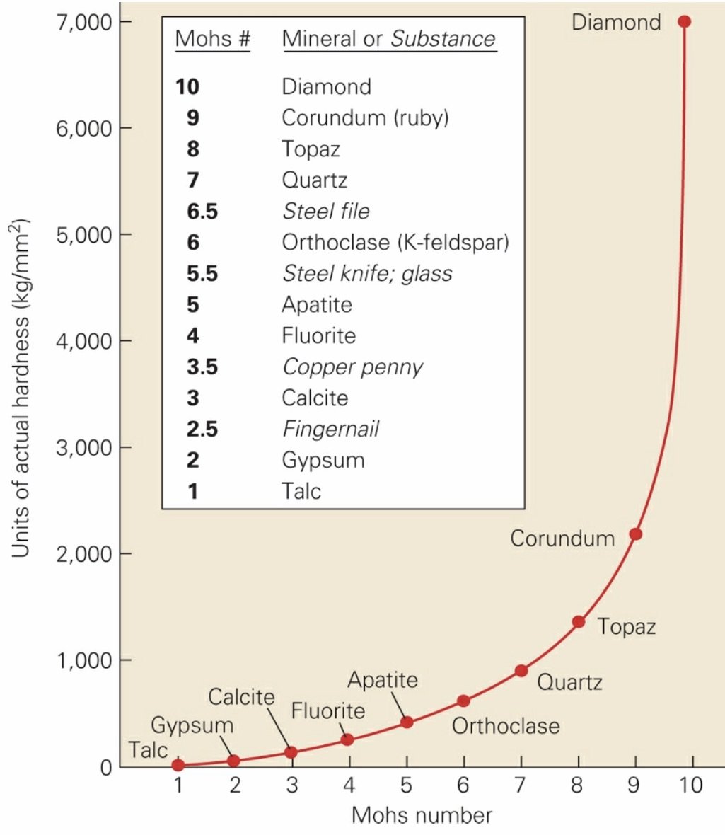
Hardness: A measure of the relative ability of a mineral to resist scratching, and it therefore represents the resistance of bonds in the crystal structure to being broken.
Mohs Scale: In the early 1800s, a mineralogist named Friedrich Mohs listed some minerals in sequence of relative hardness; a mineral with a hardness of 5 can scratch all minerals with a hardness of 5 or less.
Specific Gravity: The density of a mineral, as defined by the ratio between the weight of a volume of the mineral and the weight of an equal volume of water at 4°C.
Crystal Habit: The shape of a single crystal with well-formed crystal faces, or to the character of an aggregate of many well-formed crystals that grew together as a group.
Fracture and Cleavage: Different minerals fracture (break) in different ways. These depend on the internal arrangement of atoms in the minerals. If a mineral breaks to form distinct planar surfaces that have a specific orientation in relation to the crystal structure, then we say that the mineral has cleavage, and we refer to each surface as a cleavage plane. Materials with no cleavage at all (because bonding is equally strong in all directions) break either by forming irregular fractures or by forming conchoidal fractures. Conchoidal fractures are smoothly curving, clamshell-shaped surfaces that typically form in glass.
Mineral Chemistry
Chemical Bond: An attractive force that holds two or more atoms together.
Covalent Bonds: Form when atoms share electrons.
Ionic Bonds: Form when a cation and an anion (ions with opposite charges) get close together and attract each other.
Organic Chemicals: Consist of molecules that 1) include C-C and/or C-H bonds and 2) either form in living organisms or have structures similar to those of chemicals that form in living organisms.
Saturated: The number of dissolved ions per unit volume of solution becomes so great that they can get close enough to each other to bond together.
Crystal Lattice: 3D geometry of points representing a diffractive pattern.
Melting: Heating a mineral to a temperature at which thermal vibration of the atoms or ions in the lattice break the chemical bonds holding them to the lattice.
Dissolution: Occurs when you immerse a mineral in a solvent, such as water. Atoms or ions then separate from the crystal face and are surrounded by solvent molecules.
Gemstones: A mineral that has special value.
Some diamonds rise when rifting cracks the continental crust and causes a small part of the underlying mantle to melt. Magma generated during this process rises to the surface, bringing the diamonds with it. Near the surface, the magma solidifies to form an igneous rock called kimberlite, named for Kimberley, South Africa. Diamonds brought up with the magma are embedded as crystals in solid kimberlite.
1 carat equals 200 mg (0.2 g).
Hope Diamond: In the 1600s, a French trader named Jean-Baptiste Tavernier obtained a large (112.5 carats, where 1 carat = 200 mg), rare blue diamond in India, perhaps from a Hindu statue, and carried it back to France. King Louis XIV bought the diamond and had it fashioned into a jewel of 68 carats. This jewel vanished during a burglary in 1762. Perhaps it was lost forever—perhaps not. In 1830, a 44.5-carat blue diamond mysteriously appeared on the jewel market for sale. Henry Hope, a British banker, purchased the stone, which then became known as the Hope Diamond. It changed hands several times until 1958, when a famous New York jeweler named Harry Winston donated it to the Smithsonian Institution in Washington, DC, where it now sits behind bulletproof glass in a heavily guarded display.
Pearls: Form in living oysters when the oyster extracts Ca and CO3 ions from water and precipitates them around an impurity, such as a sand grain, embedded in its body.
___________________________________________________________________
Interlude A: Introducing Rocks
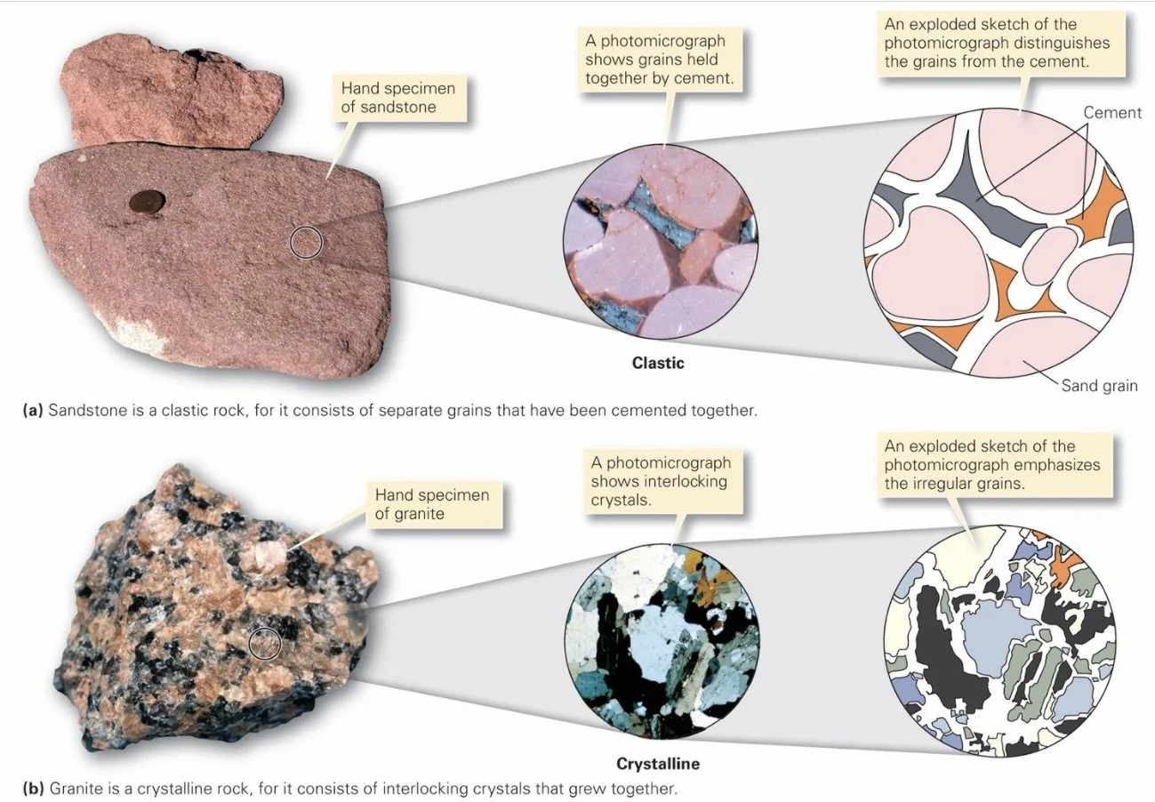
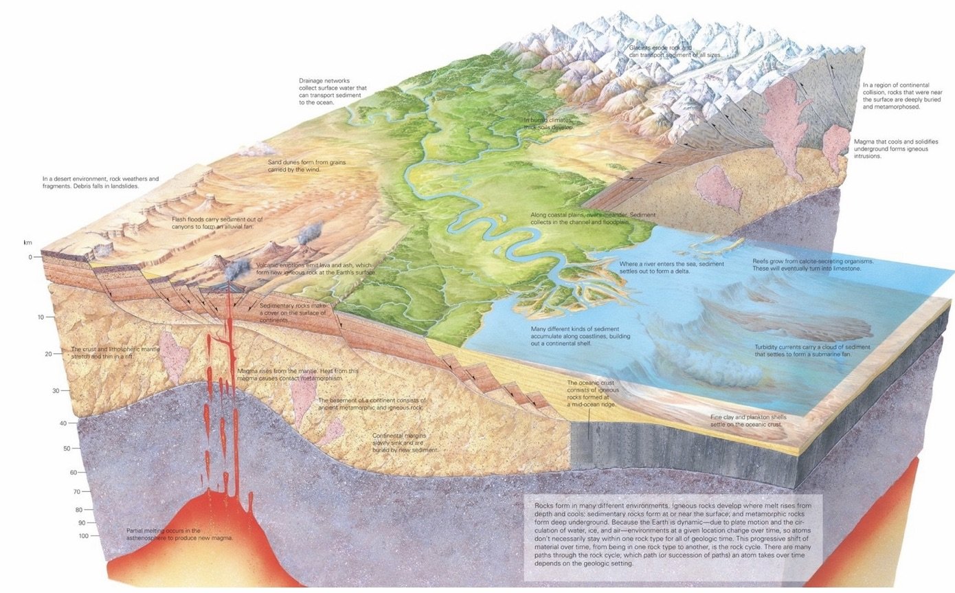
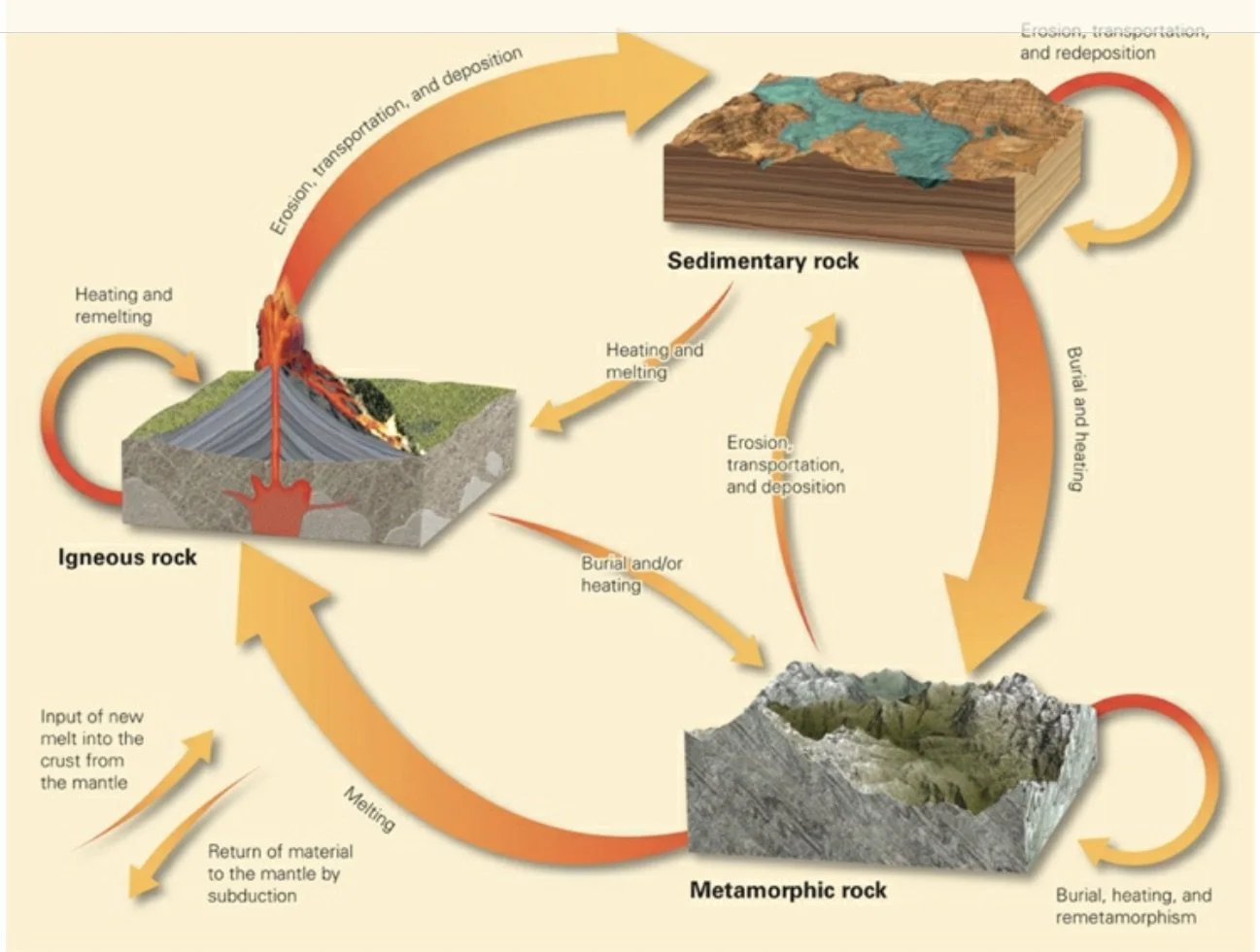
Rock: A coherent, naturally occurring solid, consisting of an aggregate of minerals or a mass of glass. Nonglassy rocks can be classified as crystalline or clastic. Geologists recognize three basic groups; 1) igneous rocks, which form by the freezing (solidification) of molten rock; 2) sedimentary rocks, which form either by the cementing together of fragments (grains) that had broken off pre-existing rocks, or by the precipitation of mineral crystals out of water solutions at or near the Earth’s surface; and 3) metamorphic rocks, which form when pre-existing rocks change character in response to a change in temperature, pressure, or chemical environment.
Grains in rock stick together to form a coherent mass either because they are bonded by natural cement, mineral material that precipitates from water and fills the space between grains, or because they interlock with one another like pieces of a jigsaw puzzle.
At the surface of the Earth, rock occurs either as broken chunks (pebbles, cobbles, or boulders).
Clastic Rocks: Rocks whose grains are stuck together by cement.
Crystalline Rocks: Rocks whose crystals interlock with one another.
Outcrop: An exposure of bedrock.
Cement: A mineral material that precipitates from water and fills the spaces between grains, holding the grains together.
Bedrock: Rock still attached to the Earth’s crust.
Mass Spectrometer: Analyzes the proportions of atoms with different atomic weights contained in a rock.
X-Ray Diffractometer: Identifies minerals by measuring how X-ray beams interact with crystals.
___________________________________________________________________
Ch 4: Magma and Igneous Rocks
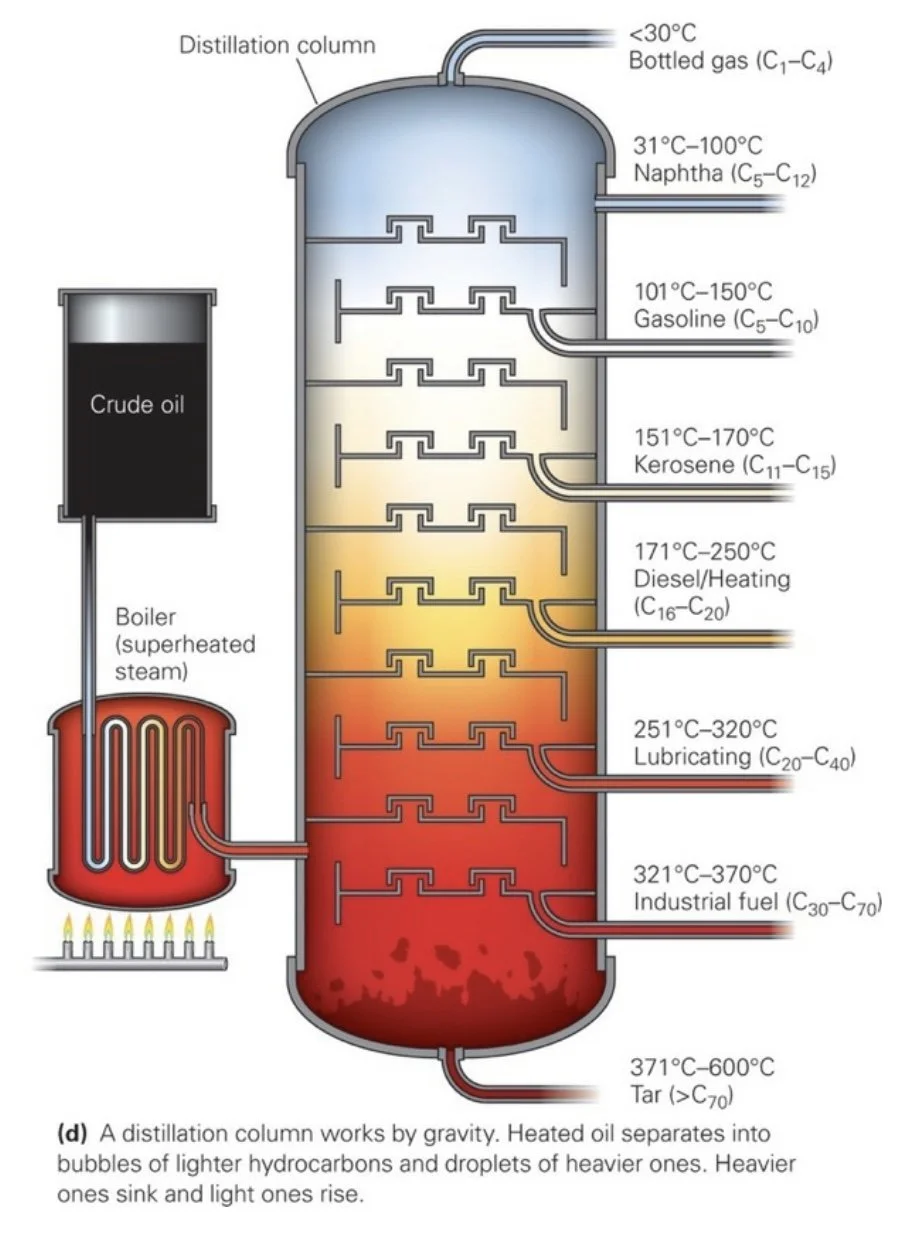
All molten rocks (magma or lava) contain silica, a compound of silicon and oxygen (SiO2).
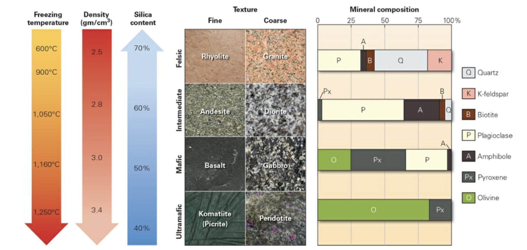
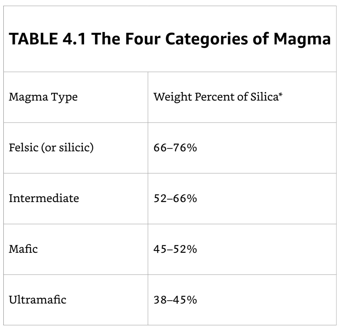
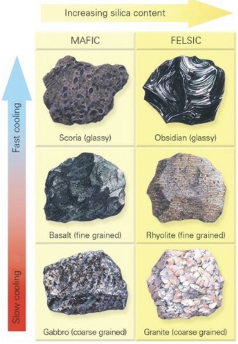
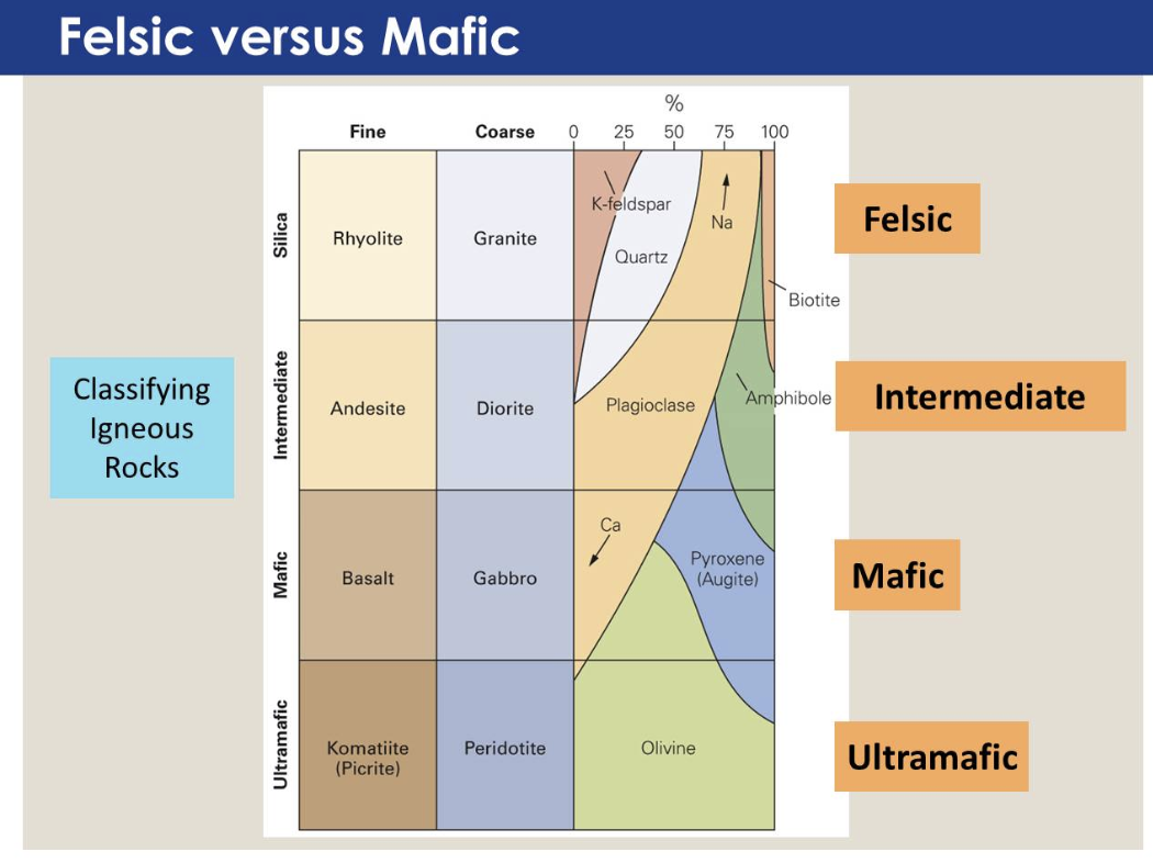
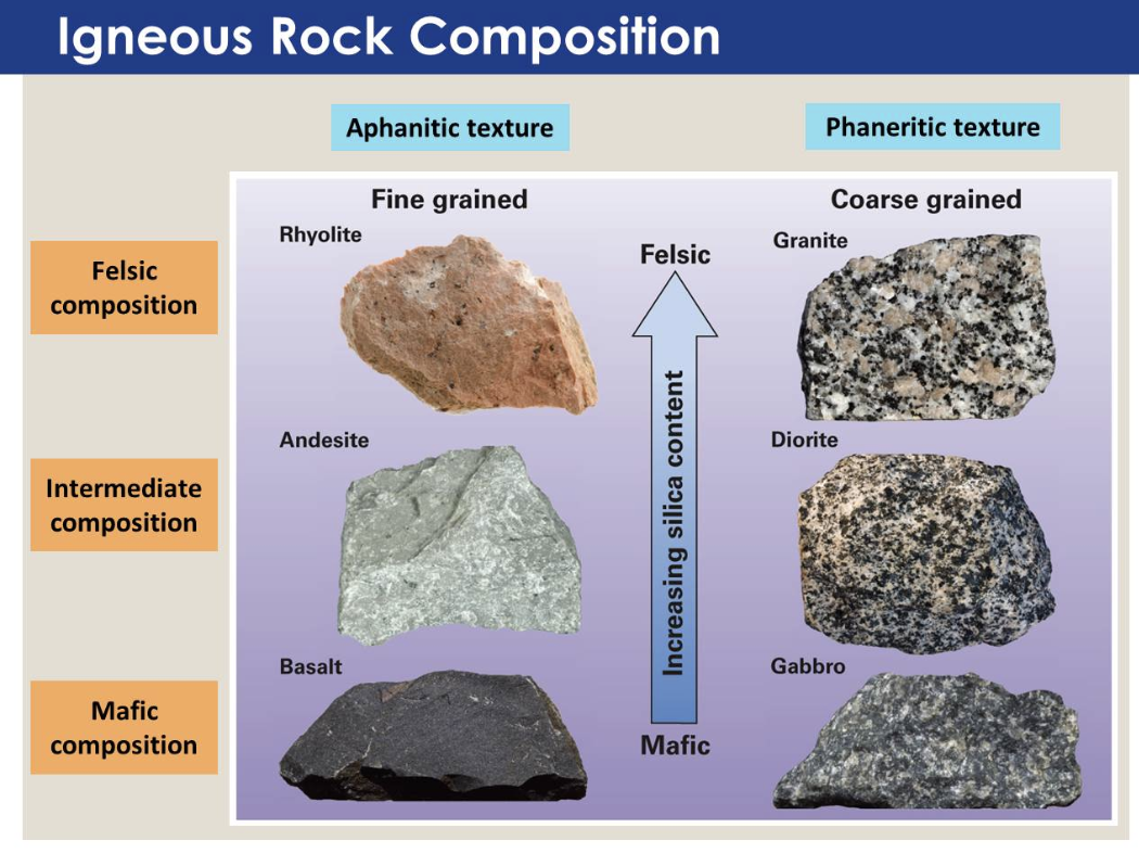
Geologists distinguish among four major compositional melt types depending, overall, on the proportion of silica (SiO2) relative to the sum of magnesium oxide (MgO) and iron oxide (FeO or Fe2O3 ) in the melt.
Mafic (Ma- Mg, -fic- Fe): Contain a relatively high proportion of MgO & FeO compared to silica.
Ultramafic: Contain an even higher proportion of MgO & FeO, relative to silica.
Felsic (aka silicic): Contain a fairly high proportion of silica, compared to MgO & FeO.
Intermediate: Composition is partway between that of mafic and felsic melts.
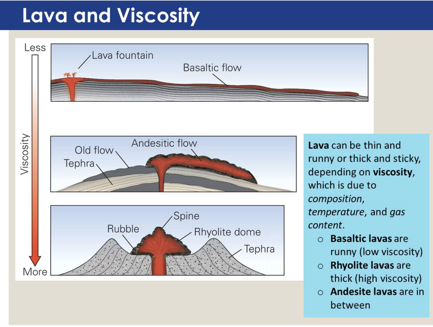
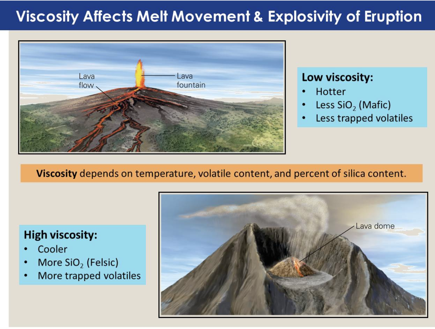
Viscosity: Resistance to flow.
Mafic Lavas: Tend to have low viscosity and spread in broad, thin flows.
Felsic Lavas: Tend to erupt explosively and form thick ash and debris deposits.
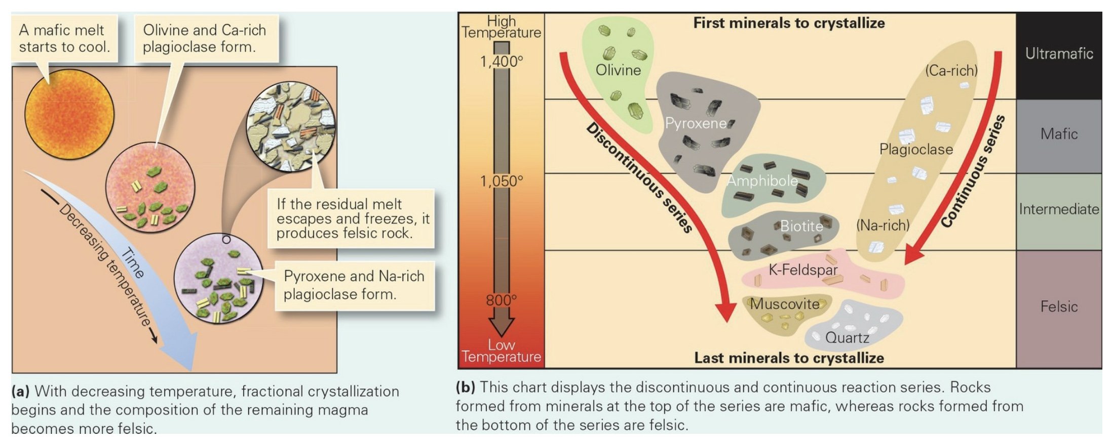
Fractional Crystallization: The process of sequential crystal formation, as cooling takes place.
If a mafic magma freezes before much fractional crystallization has occurred, a mafic igneous rock forms. Freezing of the magma that remains after much fractional crystallization has occurred yields a felsic igneous rock.
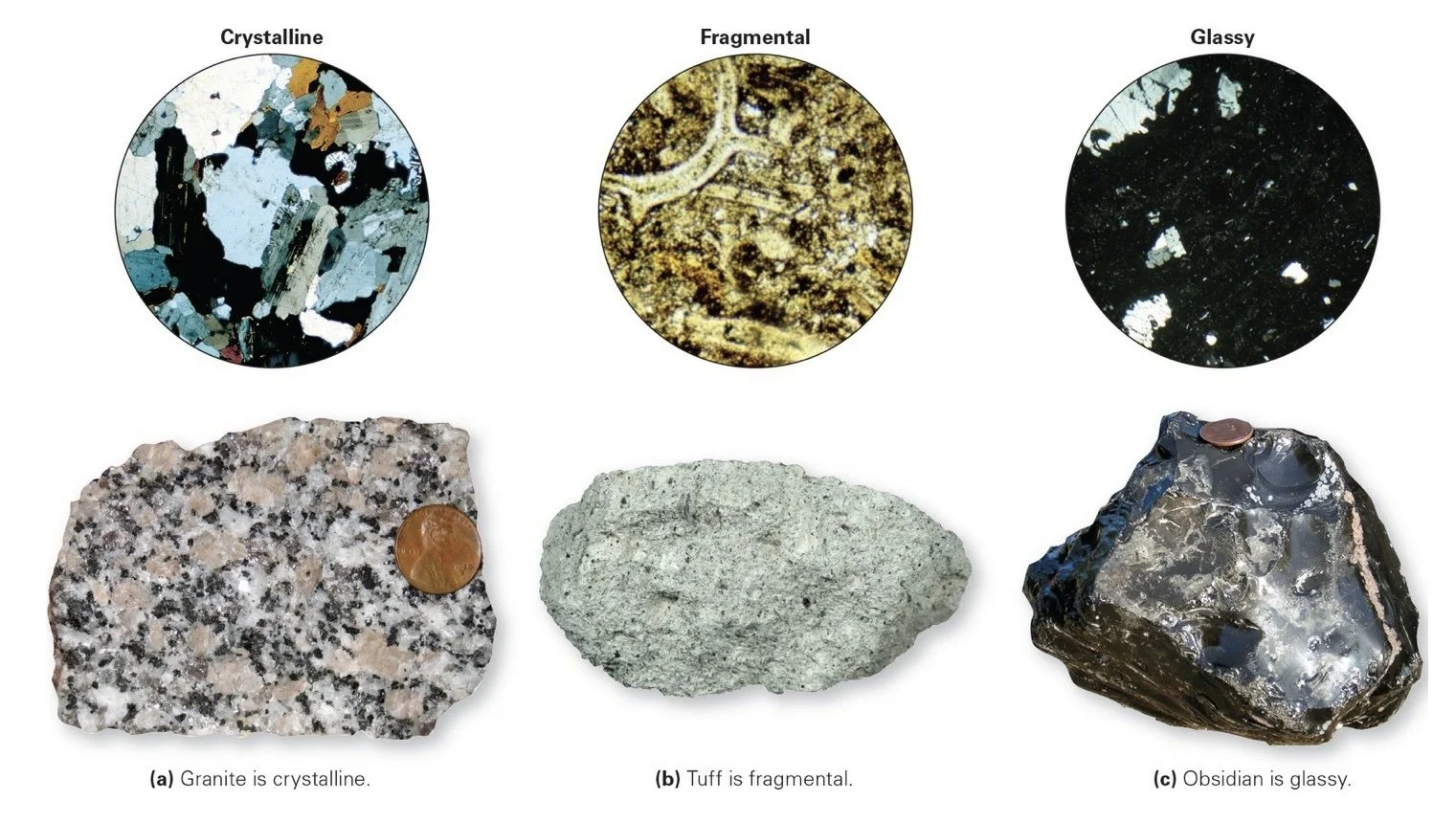
Rapid Cooling: Solidifies before seeds have grown into crystals, resulting in a glassy texture.
Fast Cooling (rapid, but not rapid enough to form glass): Develops a fine-grained (aphanitic) texture. Many crystals in the resulting rocks will have grown from seeds, but none of those crystals will have had enough time to grow large.
Slow Cooling: Successful crystals have time to grow large before the rock solidifies completely.
Vesicles: The open holes present in rocks that occurs when a rapidly cooling lava freezes while it still contains a high concentration of gas bubbles.
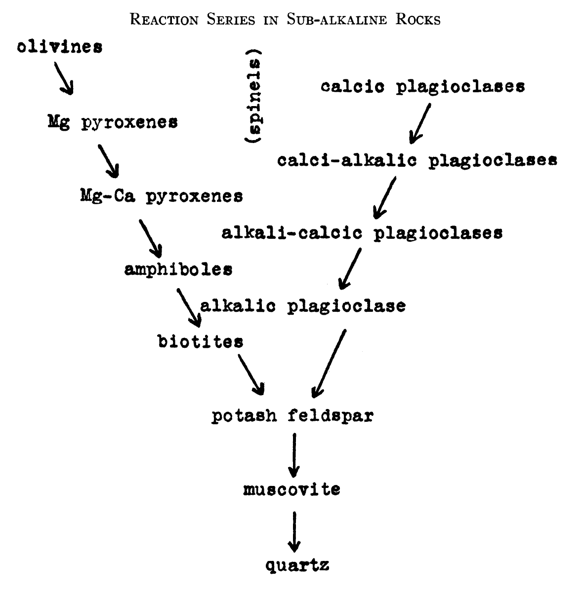
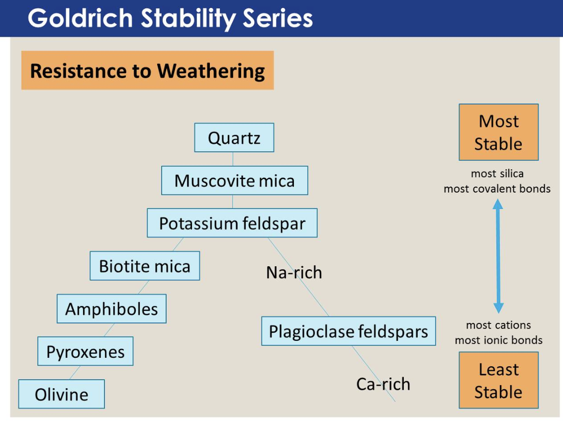
Bowens Reaction Series: Has two distinct tracks (based on Norman L. Bowens 1920’s experiments to determine the sequence in which silicate minerals crystallize from a melt).
Discontinuous Reaction Series: Refers to the sequence of olivine, pyroxene, amphibole, biotite, K-feldspar/muscovite/quartz, in that each step yields a different kind of silicate mineral.
Continuous Reaction Series: Refers to the sequence from Ca-rich to Na-rich plagioclase, in that each step yields a different version of the same mineral.
Rock Texture: Distinguished by fine or coarse grained. A rock’s texture tells us about the rate at which it cooled.
Phaneritic: Coarse-grained rocks with crystals large enough to identify with the naked eye.
Aphanitic: Fine grained rocks with crystals too small to identify with the naked eye.
Porphyritic: Rocks comprised of larger crystals (called phenocrysts) surrounded by a mass of fine crystals (called groundmass).
Glassy Texture: Rocks made of a solid mass of glass or of tiny crystals surrounded.
Fragmental Igneous Rocks: Form from pyroclastic debris and consist of chunks or shards that are packed together, welded together, or cemented together after they have solidified
Igneous Rock Types
Obsidian: A mass of solid, felsic glass; tends to be black or brown. It breaks conchoidally, sharp-edged pieces split off its surface when you hit a sample with a hammer.
Pumice: A felsic volcanic rock that contains abundant (75-90% of the rock’s volume) tiny vesicles, each surrounded by a thin screen of glass. With far more open space than solid glass, it can look like a sponge, and some specimens can actually float on water, like Styrofoam. Pumice forms from quickly cooling, volatile-rich frothy lava.
Scoria: A mafic volcanic rock with numerous vesicles (>30%). Generally, the bubbles in scoria are bigger than those in pumice, and the rock looks darker, overall.
Tuff: Consists mostly of volcanic ash.
Intrusions
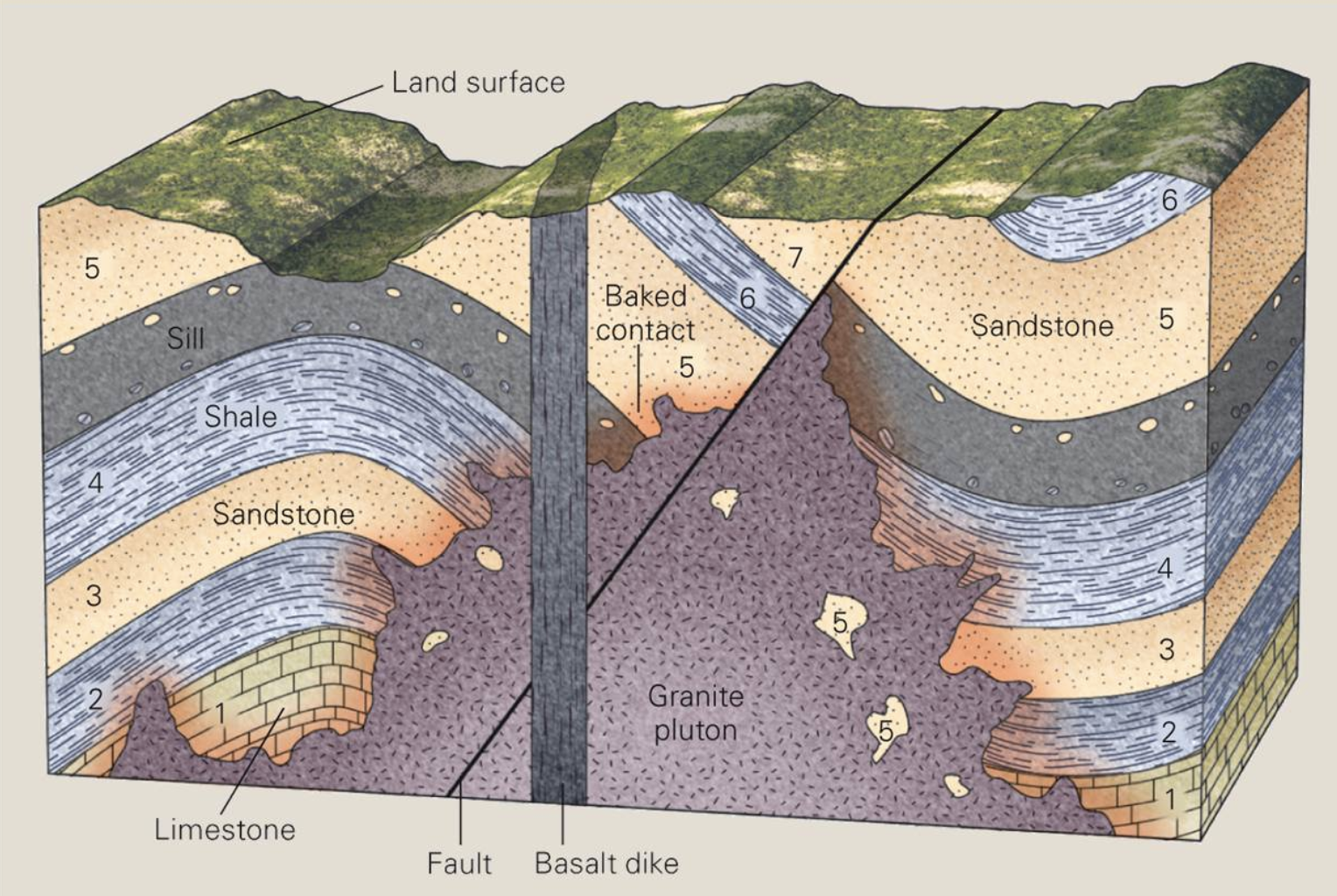
Dike: A tabular intrusion that cuts across pre-existing layering (bedding or foliation).
Sill: A tabular intrusion that injects between layers, and, therefore, parallels layering.
Laccolith: An intrusion that starts to inject between layers but then domes upward, yielding a blister-shaped intrusion.
Plutons: Blob-shaped intrusions that range in size from tens of meters across to tens of kilometers across.
___________________________________________________________________
Ch 5: Volcanic Eruptions
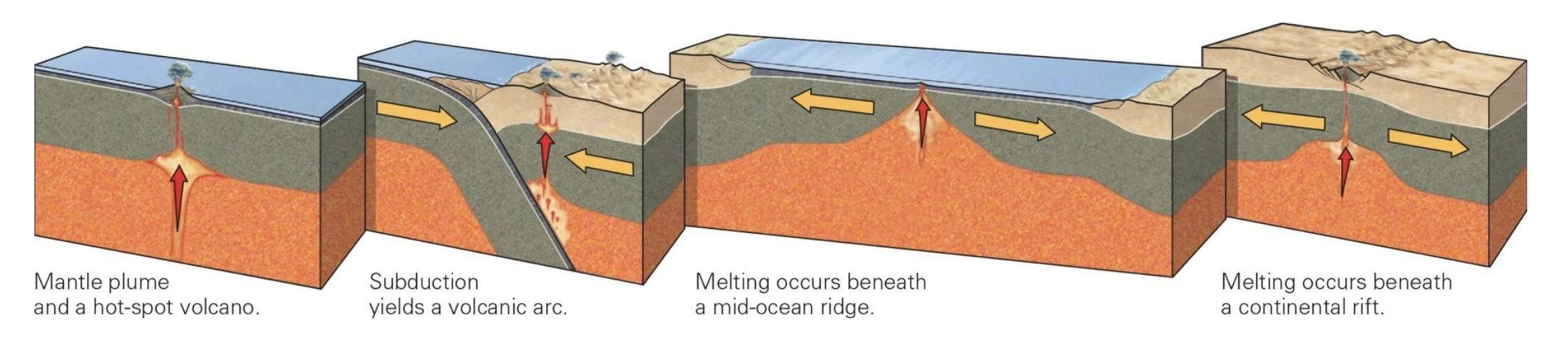
Melting: Occurs in special locations where conditions lead to decompression, addition of volatiles, or heat transfer. The conditions that lead to melting and igneous activity can develop in four geologic settings: 1) hot spots; 2) along volcanic arcs bordering oceanic trenches; 3) along mid-ocean ridges; and 4) within continental rifts.
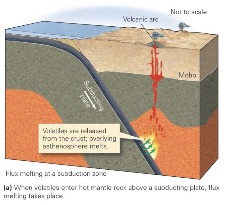
Volcanic Arcs: At shallow depths, volatiles are bonded to other elements within mineral crystals. But when subduction carries crust down into the hot asthenosphere, the crust warms up, and at a depth of about 150 km, it becomes so hot that volatiles separate and diffuse up into the overlying hot ultramafic rock (peridotite) of the asthenosphere as molecules of H2O or, to a lesser extent, CO2. These volatiles cause flux melting of peridotite.
Rifts: Places where continental lithosphere stretches horizontally. As a result of this stretching, the lithosphere also thins vertically. As this process takes place, the asthenosphere undergoes decompression.
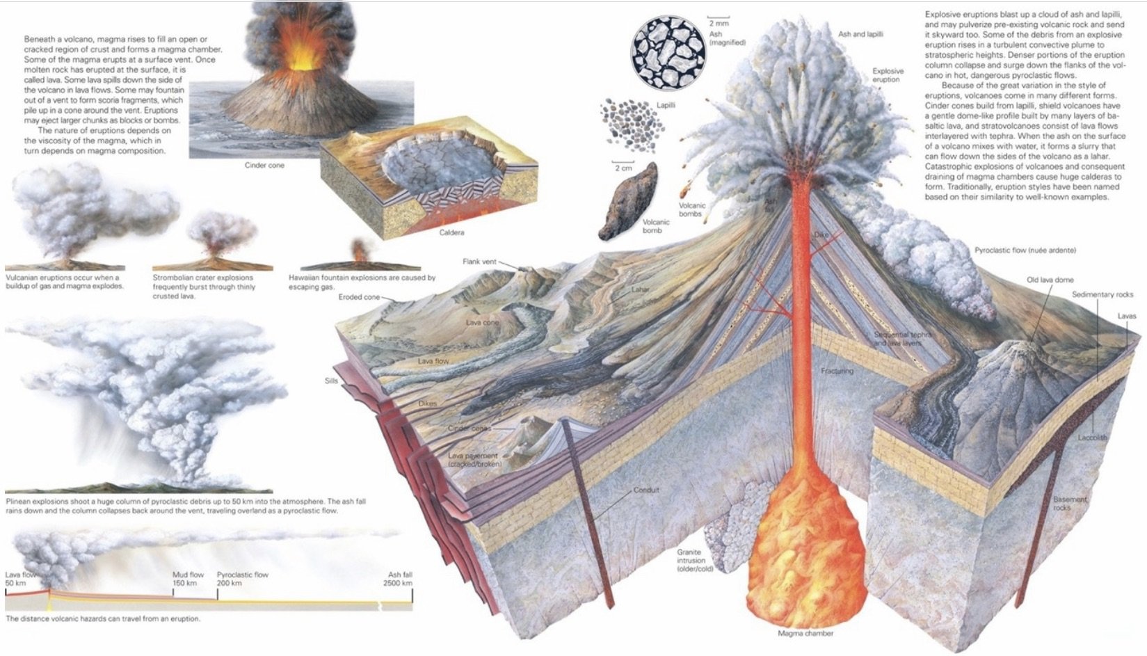
Eruption Products: Come in three forms—lava flows, pyroclastic debris, and gas.
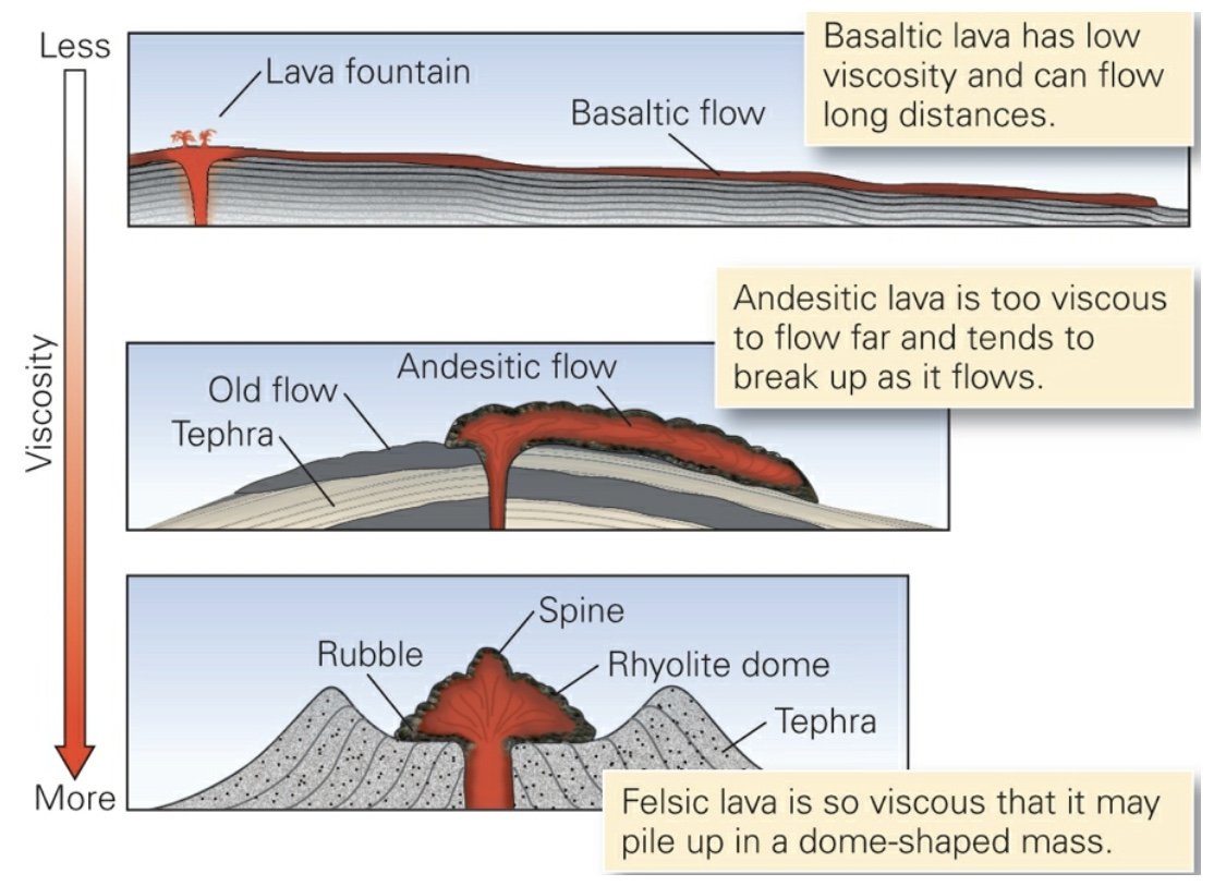
Silica in lava tends to bond together into large molecules that can’t move easily. Therefore, basaltic lava is less viscous than andesitic lava, which in turn is less viscous than rhyolitic lava. As a result, basaltic lava can flow farther than andesitic lava, which can flow farther than rhyolitic lava.
Basaltic (Mafic) Lava: Low viscosity lava. Basalt flows whose surfaces are warm and pasty wrinkle into smooth, glassy, rope-like ridges (pahoehoe). If a moving lava flow becomes too viscous to contort into pahoehoe ropes, the solid surface of the lava breaks up into a jumble of sharp, angular fragments, creating a rubbly flow (a’a’).
Andesitic Lava: Intermediate- composition lava with a higher viscosity than basaltic lava. When erupted, andesitic lava first forms a mound above the vent. This mound advances relatively slowly down the volcano’s flank at about 1 to 5 m a day, in a lumpy flow with a bulbous snout. If the flow extrudes onto a steep slope, the blocks may tumble down the side of a volcano while still glowing red.
Rhyolitic Lava: The most viscous type of lava because it is the most felsic and the coolest. Therefore, it tends to accumulate either above the vent in a lava dome, or in short and bulbous flows rarely more than 1 to 2 km long.
Magma: Generally, contains dissolved gases such as H2O, CO2, and SO2. In fact, up to 9% of a magma may consist of gaseous components—generally, lavas with more silica contain a greater proportion of gas.
Volcanic gases come out of solution when the magma approaches the Earth’s surface and pressure decreases, just as bubbles come out of solution in a soda when you pop the bottle top off. Commonly, water emitted by a volcano condenses into a liquid that dissolves the sulfur-bearing gases to form aerosols (tiny droplets) of sulfuric acid.
Basaltic magma rising in a volcano may contain dissolved gas. As such magma approaches the surface, the gas comes out of solution and forms bubbles. When the bubbles reach the vent of the volcano, they expand and burst, producing enough pressure to drive columns or sprays of basaltic lava upward in dramatic lava fountains.
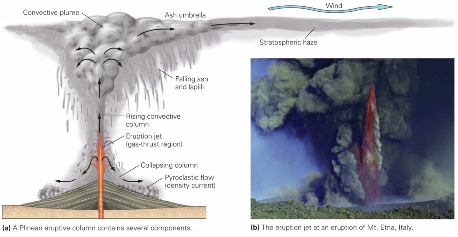
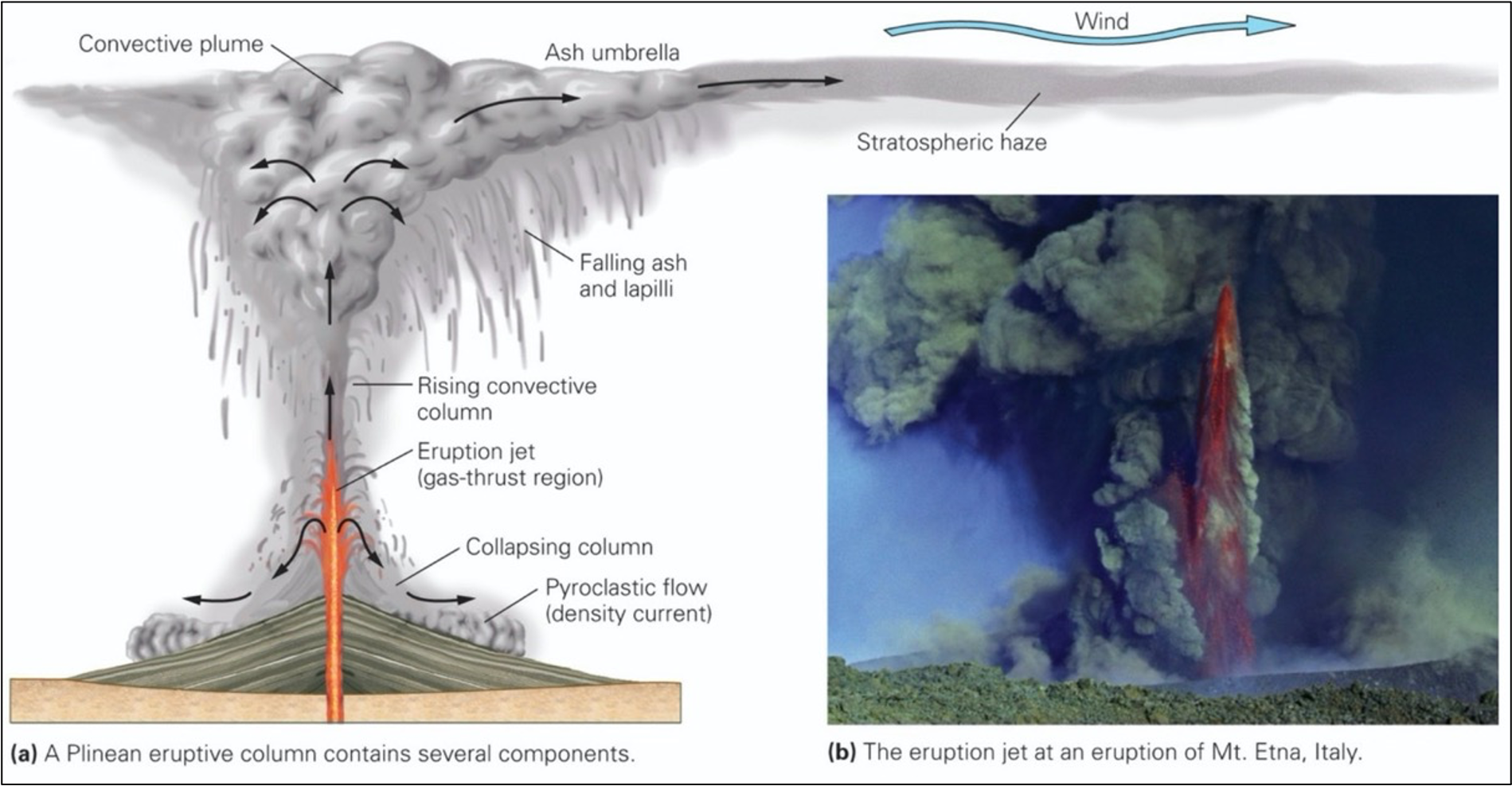
Tephra (‘Pyroclastic Debris’): Unconsolidated accumulation of pyroclastic grains. Includes various materials including specks of glass and pieces of rock formed from drops or clots of molten lava that solidified in midair or on the ground soon after falling, chunks of recently solidified lava or pumice blasted out of the volcano’s vent, and chunks formed by the forceful fragmentation of pre-existing volcanic rock surrounding the volcano’s vent.
Volcaniclastic Debris: Includes not only tephra, but also debris that tumbled down the flank of a volcano in landslides long after an eruption, debris that mixed with water to form a flowing muddy slurry, and debris originally formed at a volcano but later carried and sorted by streams.
Ash: Particles <2 mm in diameter, comprised of glass shards formed when frothy lava explosively breaks up during an eruption and the glassy walls of bubbles separate into small pieces.
Pyroclastic Debris: Fragmented material that sprayed out of a volcano and landed on the ground or sea floor in solid form.
Lapilli: Any pyroclastic particle that is 2 to 64 mm in diameter (i.e., marble-sized); the particles can consist of frozen lava clots, pumice fragments, or ash clumps.
Volcanic Ash: Tiny glass shards formed when a fine spray of exploded lava freezes instantly upon contact with the atmosphere.
Tuff: A pyroclastic igneous rock composed of volcanic ash and fragmented pumice, formed when accumulations of the debris cement together.
Volcanic Topography
Shield Volcanoes: Volcanoes built with only low-viscosity lava eruptions.
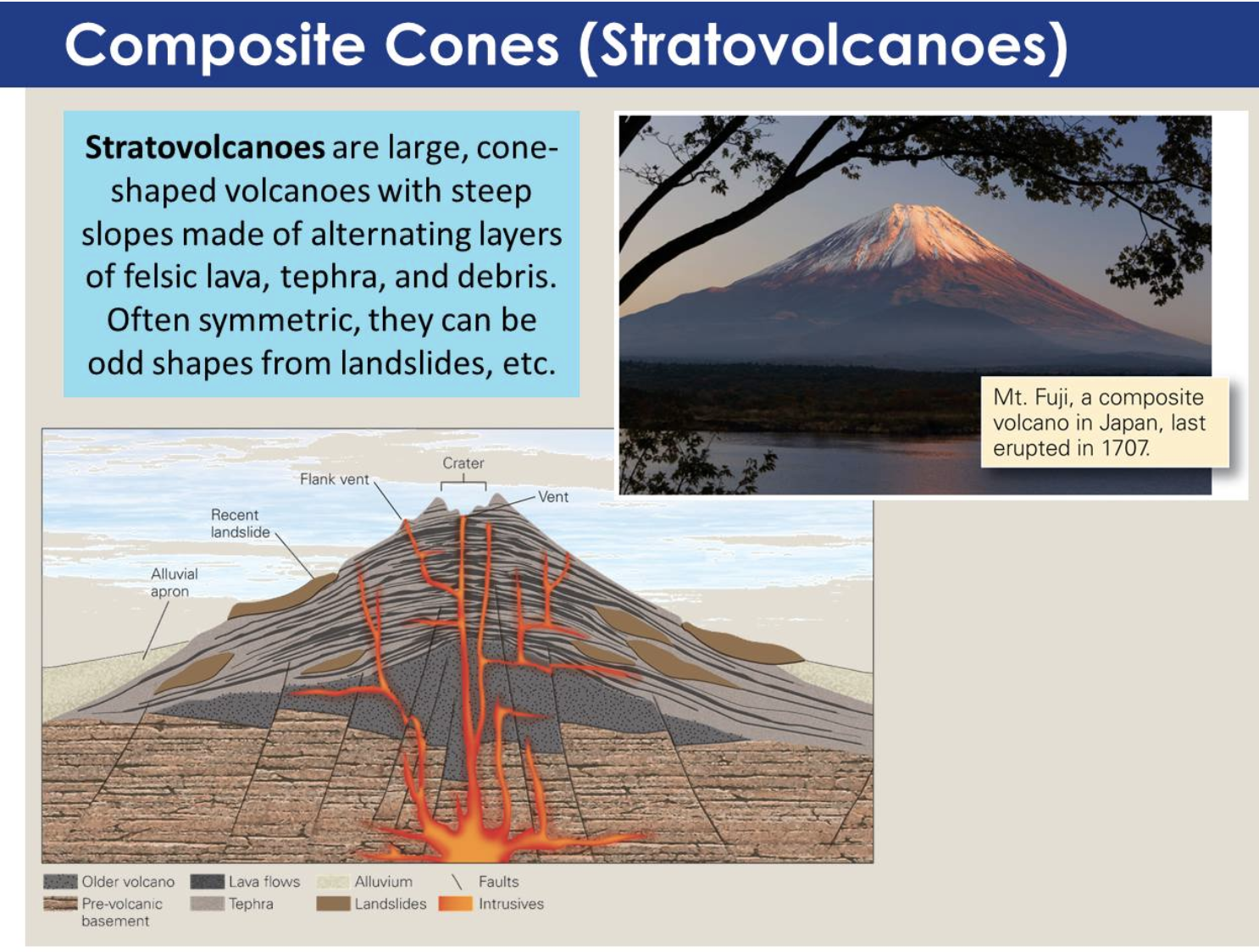
Stratovolcanoes: Volcanoes built of alternating lava and pyroclastic eruptions.
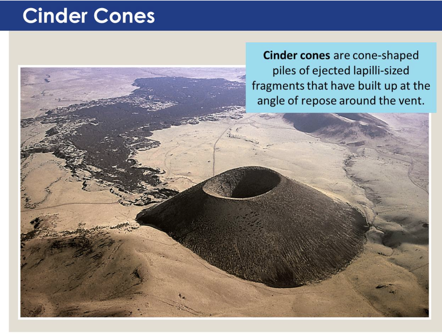
Cinder (Scoria) Cones: Consist of cone-shaped piles of basaltic lapilli and blocks that generate small pyroclastic eruptions due to fountaining basaltic lava. The steep slopes of a cinder cone represent the angle of repose for lapilli, meaning the maximum slope that the loose fragments can sustain before sliding down.
Craters: Up to 1km across and 200m deep; form either during eruption, as material accumulates around the summit vent, or just after eruption, as the summit collapses into the drained conduit.
Caldera: The much larger bowl-shaped depression that is created when a large magma chamber drains.
Ring of Fire: A 20K km chain of volcanic arcs found at convergent boundaries which border over 60% of the Pacific Ocean.
Eruptions: Gas forms bubbles as lava rises. During the final stages of its rise, as magma slowly moves up into the volcano itself, the magma may partly solidify into glass and trap the bubbles. When overlying material erupts, the pressure pushing down on a magma decreases. As external pressure decreases, because bubbles can’t expand, their internal gas pressure increases. If cracks occur in the glass screens between bubbles, the gas escapes and suddenly has room to expand. The sudden expansion blasts out any remaining melt and pulverizes the glass that had surrounded the bubbles, as well as pre-existing rock and debris that had formed the volcanic edifice. The resulting pyroclastic debris shoots out of the volcano like a shotgun blast, or like champagne spouting from a newly opened shaken bottle.
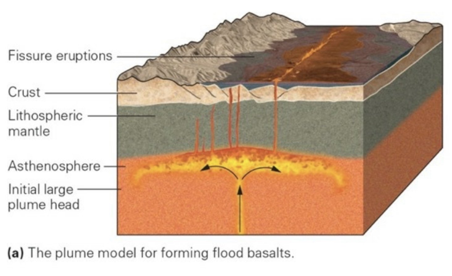
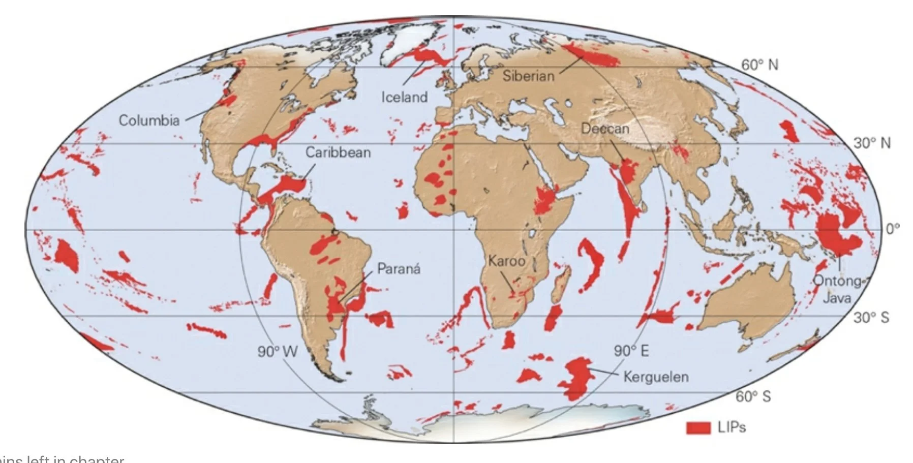
Flood Basalts: Eruptions of huge amounts of low-viscosity mafic lava that erupts out of fissures and spreads out in vast sheets. Over time, many successive eruptions of flood basalt can build up a broad plateau. The aggregate volume of rock produced by these eruptions can be so great that geologists consider them to be large igneous provinces (LIPs).
Large Igneous Province (LIP): A region in which huge volumes of lava and/or ash erupted over a relatively short interval of geologic time.
When a large explosive eruption takes place, ash and aerosols enter the stratosphere. In only about 2 weeks, winds distribute the ash and aerosol cloud around the planet. Because they circulate above the weather and do not get washed away by rainfall, the ash and aerosol may remain suspended for many months to years. The resulting haze keeps the Sun’s heat from reaching the Earth. Unlike GHGs, such as CO2, volcanic haze does not prevent heat from escaping the Earth.
Volcanic-Hazards
Lava flows overrun roads and towns.
Ash falls blanket the landscape.
Pyroclastic Flow: Move extremely fast (100 - 300 kph) and are hot (500 - 1,000°C). Pyroclastic flows incinerate towns and fields.
Landslides and lahars bury the land surface.
Earthquakes topple structures and rupture dams.
Tsunamis wash away coastal towns.
Gases suffocate people and animals.
Volcanic-Hazard Assessment Map: Maps that show areas that lie in the path of potential lava flows, lahars, or pyroclastic flows and should therefore be evacuated if a volcano starts to erupt.
___________________________________________________________________
Interlude B: Sediments and Soils
Soil Formation
1) Chemical and physical weathering produce loose debris and ions in solution. The resulting detritus consists of mineral grains (such as quartz sand or silt), as well as new weathering products (such as clay).
2) Downward-percolating water, mostly from rain that has seeped into the ground, redistributes ions and fine clay flakes. Closer to the ground surface, in the zone of leaching, the water extractions, picks up clay, and carries this material further downward. Deeper down, in the zone of accumulation, new mineral crystals precipitate out of the percolating water, and because the rate of water movement slows, the water leaves behind its load of fine clay.
3) At and just below the ground surface, detritus interacts with organisms. Organic material such as dead leaves, roots, and animals, along with waste materials from animals, mixes into the inorganic minerals of the detritus. Microbes, fungi, and insects decompose this organic material, breaking large and complex organic chemicals down into simpler ones. Some of these organisms also absorb nutrients from inorganic minerals or release acids that dissolve minerals. Finally, plant roots or burrowing animals (insects, worms, and gophers) churn and break up the debris that may have clumped together.
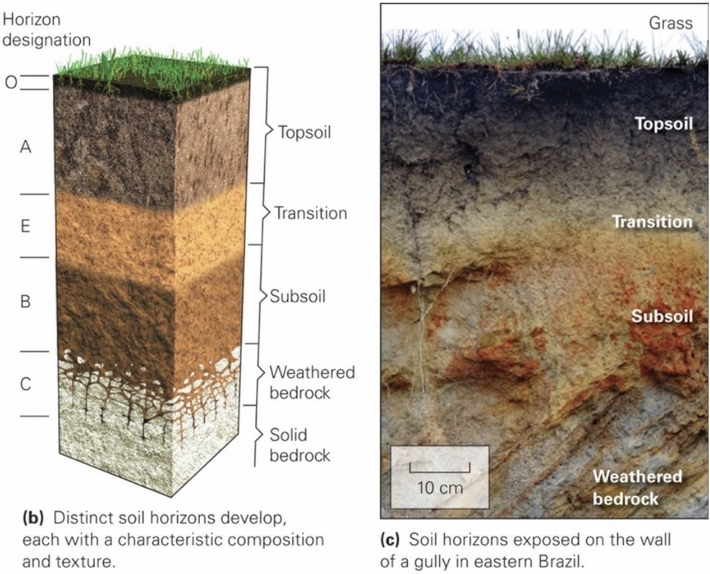
Soil Profile: A vertical sequence of distinct zones of soil.
Soil Horizon: Distinct zones within a soil, distinguished from each other by factors such as chemical composition and organic content.
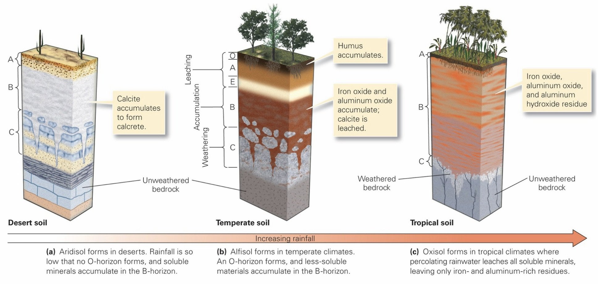
Temperate Forest Soil Profile (from top to bottom)
O-Horizon: The highest (O is for organic); consists almost entirely of humus (plant debris) with barely any mineral matter.
A-Horizon: Beneath the O-horizon; humus has decayed further and has mixed with clay, silt, and sand. Water percolating down through the A-horizon causes further chemical weathering reactions to occur, yielding ions in solution and new clay minerals. Downward-moving water eventually carries soluble chemicals and fine clay deeper into the subsurface. The O- and A-horizons constitute dark-gray to blackish-brown topsoil, the fertile portion of soil that farmers till for planting crops.
In some places, the A-horizon grades downward into the E-horizon, a soil level that has undergone substantial leaching but has not yet mixed with organic material.
B-Horizon (‘Subsoil’): Zone of accumulation; Ions and clay accumulate in the B-horizon, or subsoil
C-horizon: The base of subsoil; consists of material derived from the substrate that’s been chemically weathered and broken apart, but has not yet undergone leaching or accumulation. The C-horizon grades downward into unweathered bedrock or into unweathered sediment.
Zone of Leaching: The layer of regolith in which water dissolves ions and picks up very fine clay; these materials are then carried downward by infiltrating water. Includes the O, A, and E horizons.
Zone of Accumulation: The layer of regolith in which new minerals precipitate out of water passing through, thus leaving behind a load of fine clay. Also the area of a glacier in which snowfall adds to the glacier.
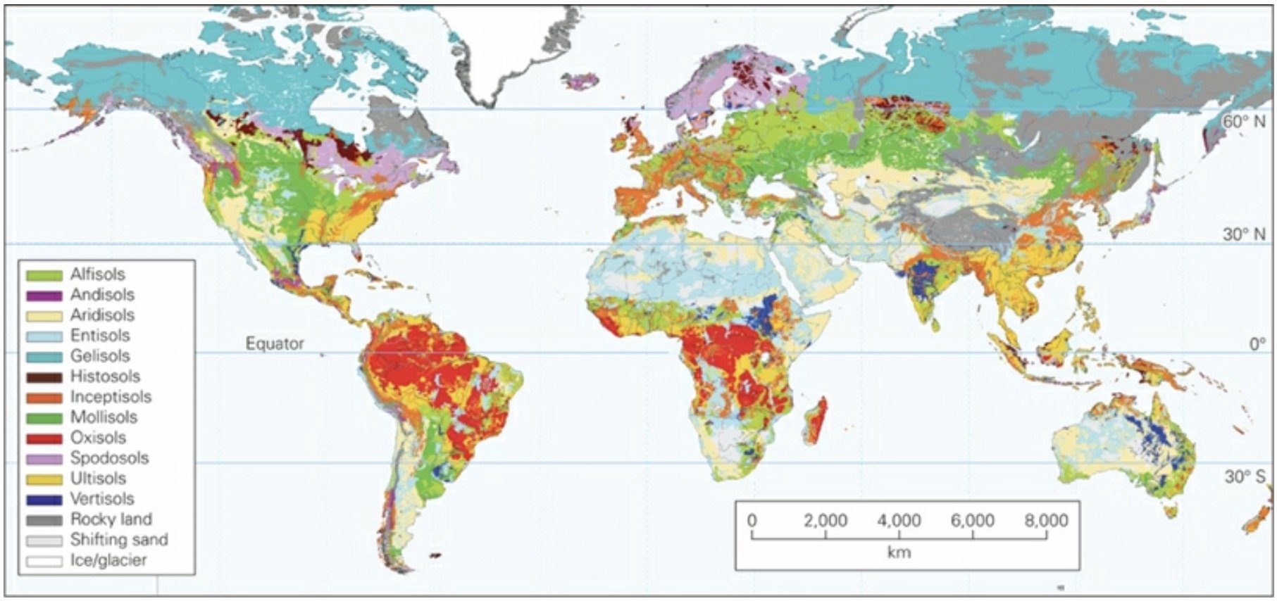
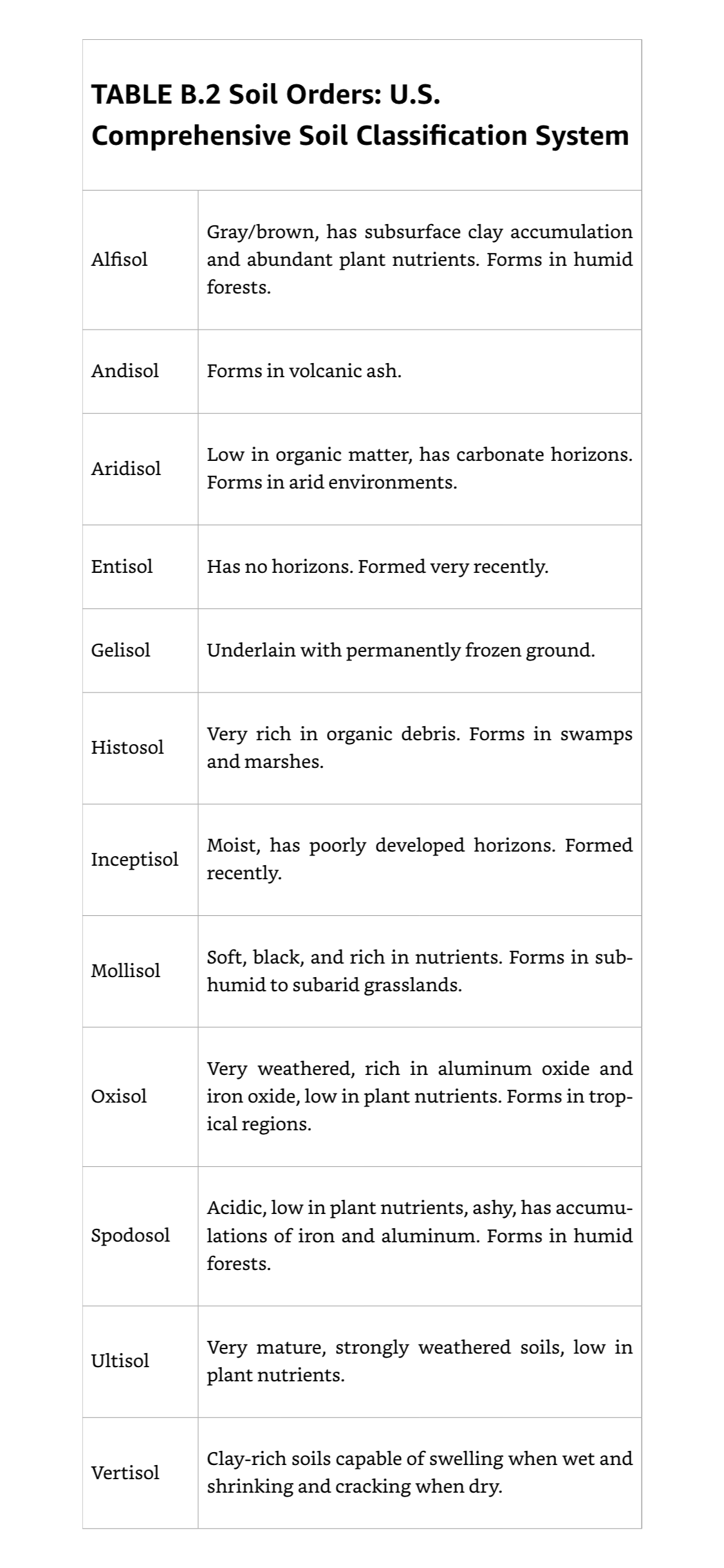
US Comprehensive Soil Classification System: Used by soil scientists to distinguish among 12 soil orders based on the physical characteristics and environment of soil formation; https://www.nrcs.usda.gov/resources/guides-and-instructions/soil-taxonomy.
___________________________________________________________________
Ch 6: Sedimentary Rocks
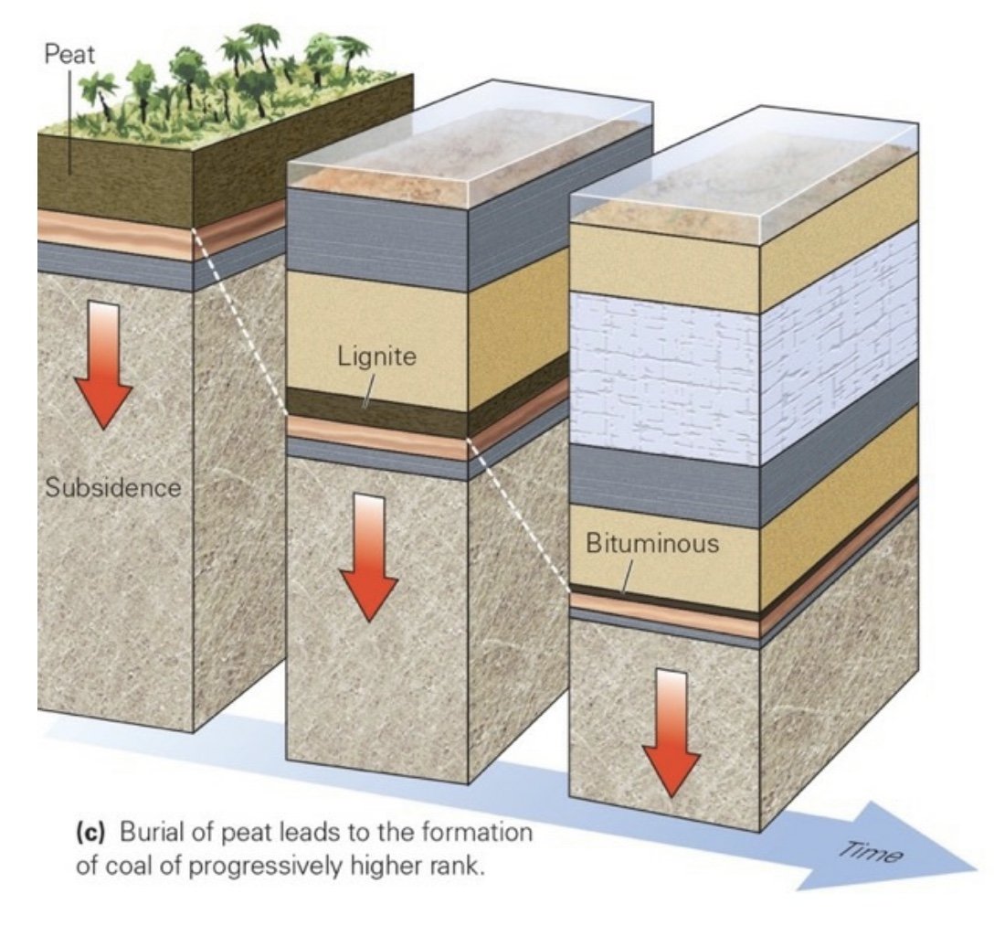
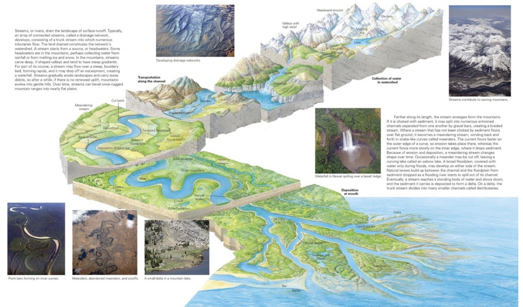
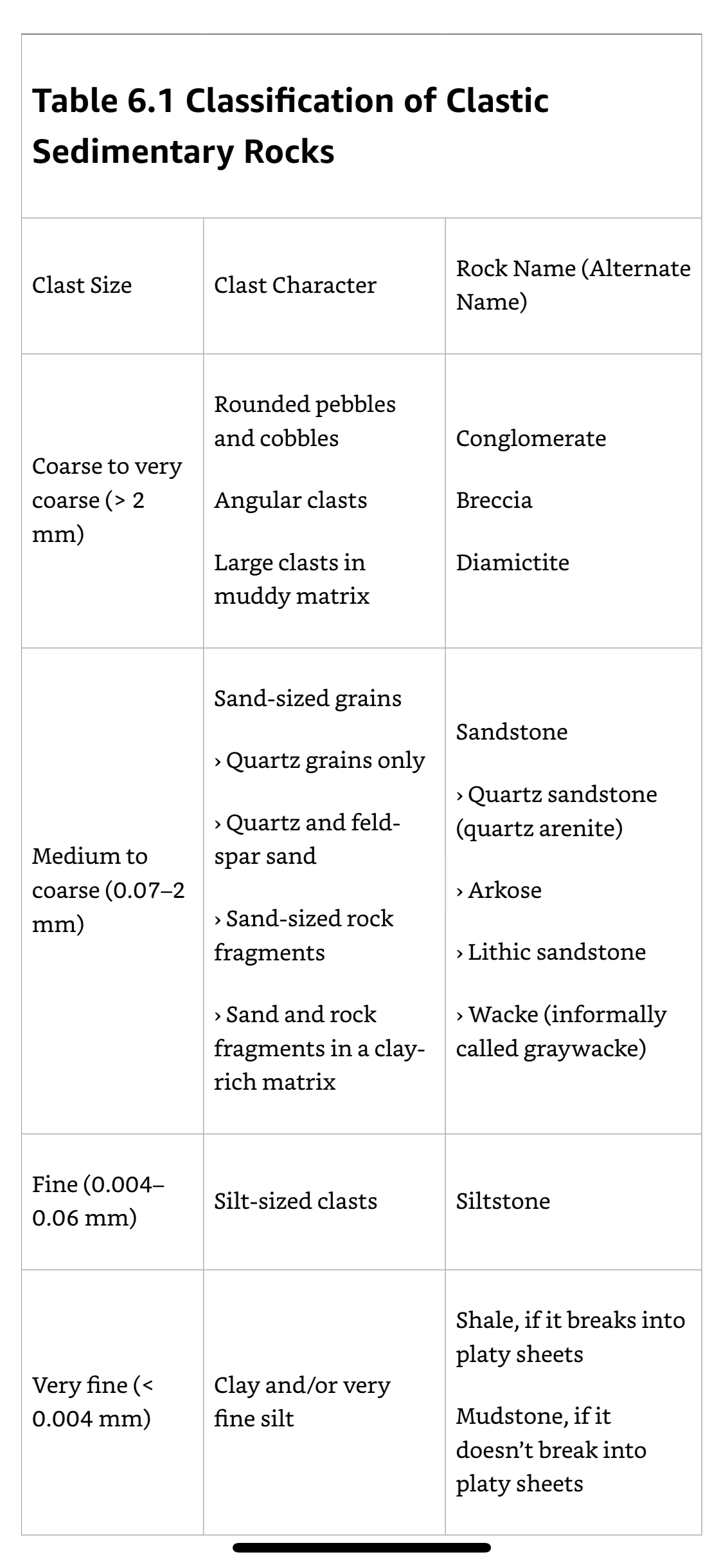
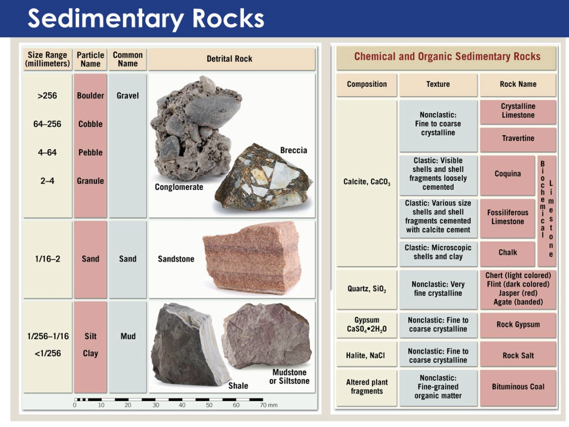
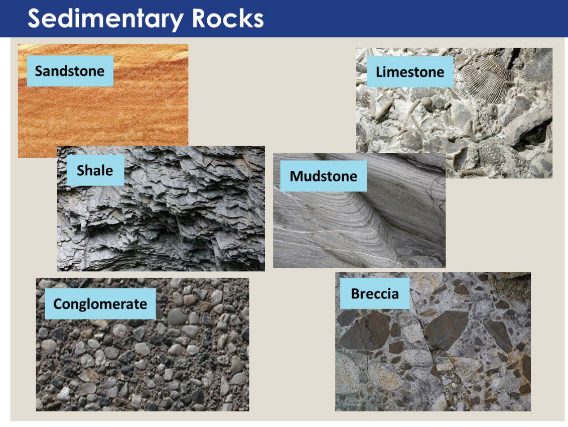
Sedimentary Rock: Rock that forms at or near the surface of the Earth by the cementing together of loose clasts (fragments or grains) produced by physical or chemical weathering; by the growth of mounds of shells; by the cementing together of shells and shell fragments; by the accumulation and subsequent alteration of organic matter derived from living organisms; and by the precipitation of minerals directly from surface-water solutions. Rocks are divided into 4 major classes, based on their mode of origin.
Clastic Sedimentary Rocks: Form from cemented-together grains that were first produced by weathering and were then transported, deposited, and lithified. Formation of clastic rocks begins when grains erode from pre-existing rock. Moving water, air, or ice transport these grains to a site of deposition, where they accumulate. Lithification, involving compaction and cementation, which converts loose sediment into rock. Clastic rocks are classified primarily by grain size.
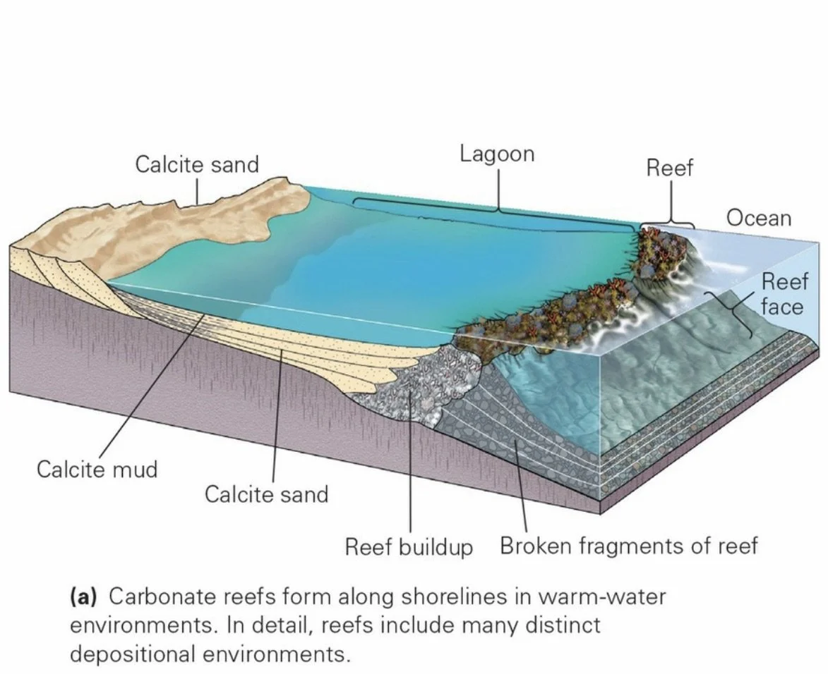
Biochemical Sedimentary Rocks: Sedimentary rock formed from the shells of organisms.
Organic Sedimentary Rocks: Sedimentary rock formed from plant debris or the altered remains of plankton.
Petrified Wood: Chert that forms when silica-rich sediment, such as ash from a volcanic eruption, buries trees. The silica dissolves in groundwater and then later precipitates as microcrystalline quartz within wood, gradually replacing the wood’s cellulose
Chemical Sedimentary Rocks: Sedimentary rock that precipitates directly from water.
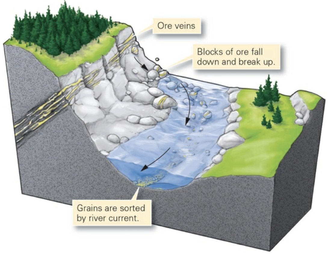
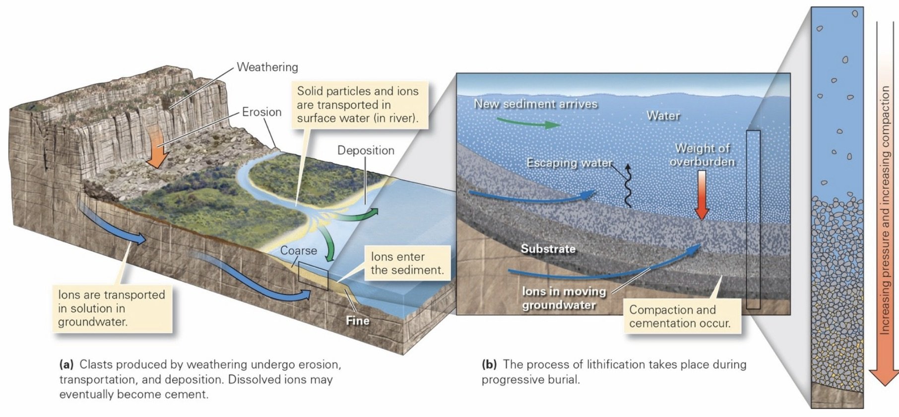
Sediment: Loose fragments of rocks or minerals broken off bedrock, mineral crystals that precipitate directly out of water, and shells or shell fragments. The materials in sediments ultimately comes from the weathering (physical and chemical breakdown) of pre-existing rock.
Diagenesis: The physical, chemical, and biological processes that transform sediment into sedimentary rock and that alter characteristics of sedimentary rock after the rock has formed.
Weathering: Clasts form by disintegration of bedrock into separate grains due to physical and chemical weathering.
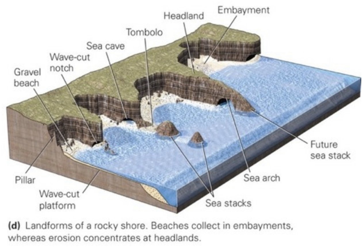
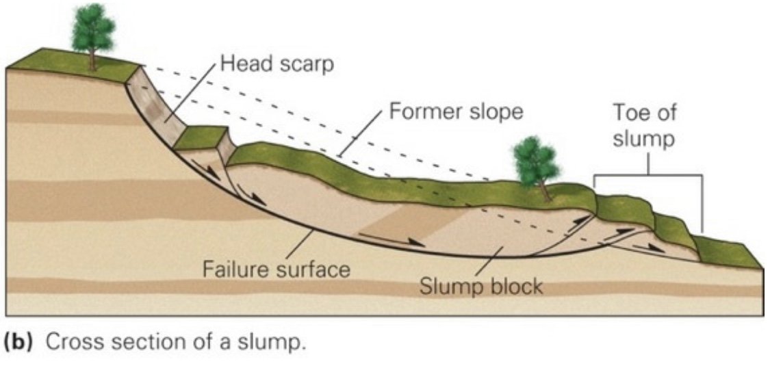
Erosion: The combination of processes that separate rock or regolith (surface debris) from its substrate. Erosion involves abrasion, falling, plucking, scouring, and dissolution, and can be caused by moving air, water, or ice.
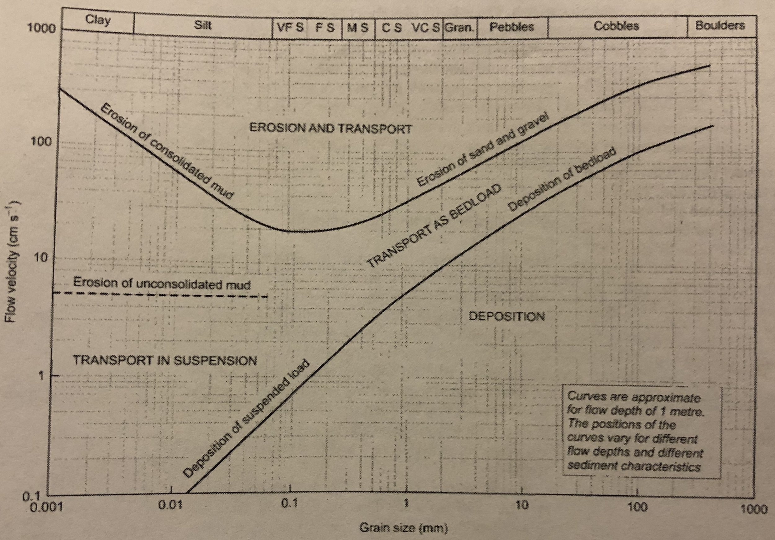
Transportation: Gravity, wind, water, or ice can carry sediment. The ability of a medium to carry sediment depends on the medium’s viscosity and velocity. Solid ice can transport sediment of any size, regardless of how slowly the ice moves. Very fast-moving, turbulent water can transport coarse fragments (cobbles and boulders), as well as finer ones; moderately fast-moving water can carry only sand and gravel; and slow-moving water carries only finer-grained sediments, such as silt and clay. Strong winds can move sand and dust, but gentle breezes carry only dust.
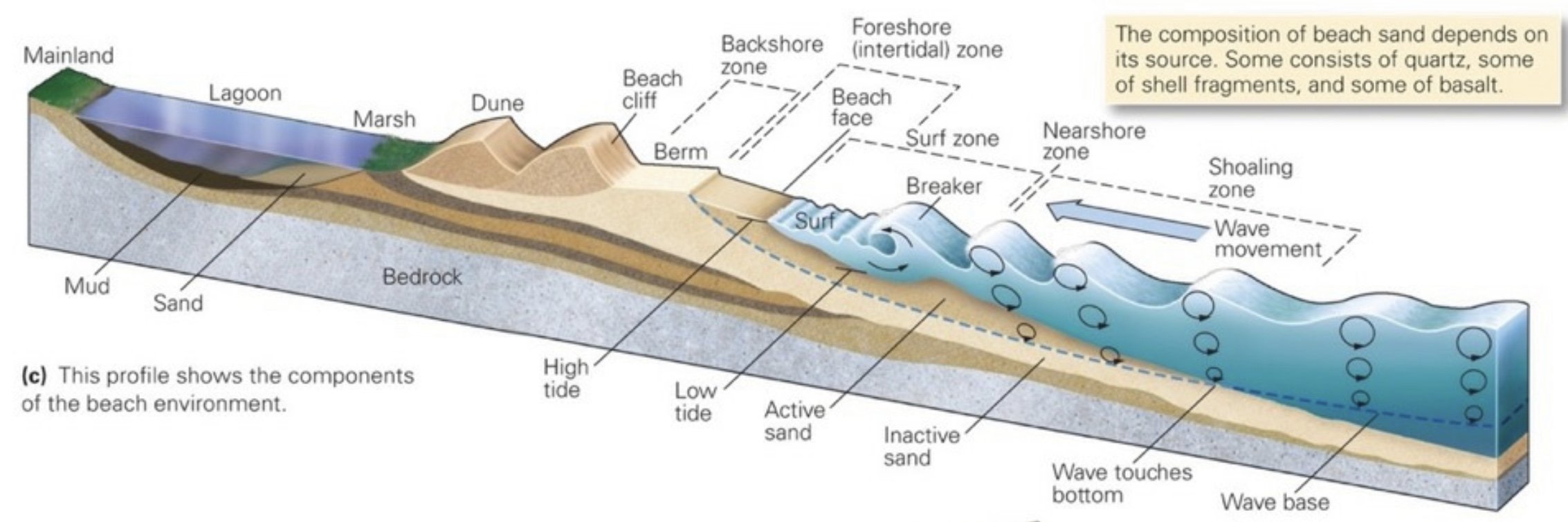
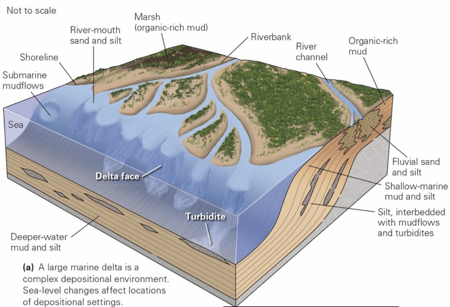
Deposition: The process by which sediment settles out of the transporting medium. Sediment settles out of wind or moving water when these fluids slow down, because as the velocity decreases, the fluids no longer have the ability to carry sediment. Sediment carried by ice accumulates when the ice melts. Three basic categories of depositional environments: terrestrial, coastal, and marine.
Terrestrial Depositional Environment: Those that develop inland, far enough from the shoreline that they are not affected by ocean tides and waves.
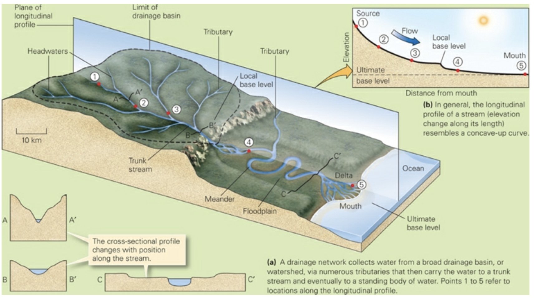
Fluvial Sediments (fluvius: river, Latin): River deposits.
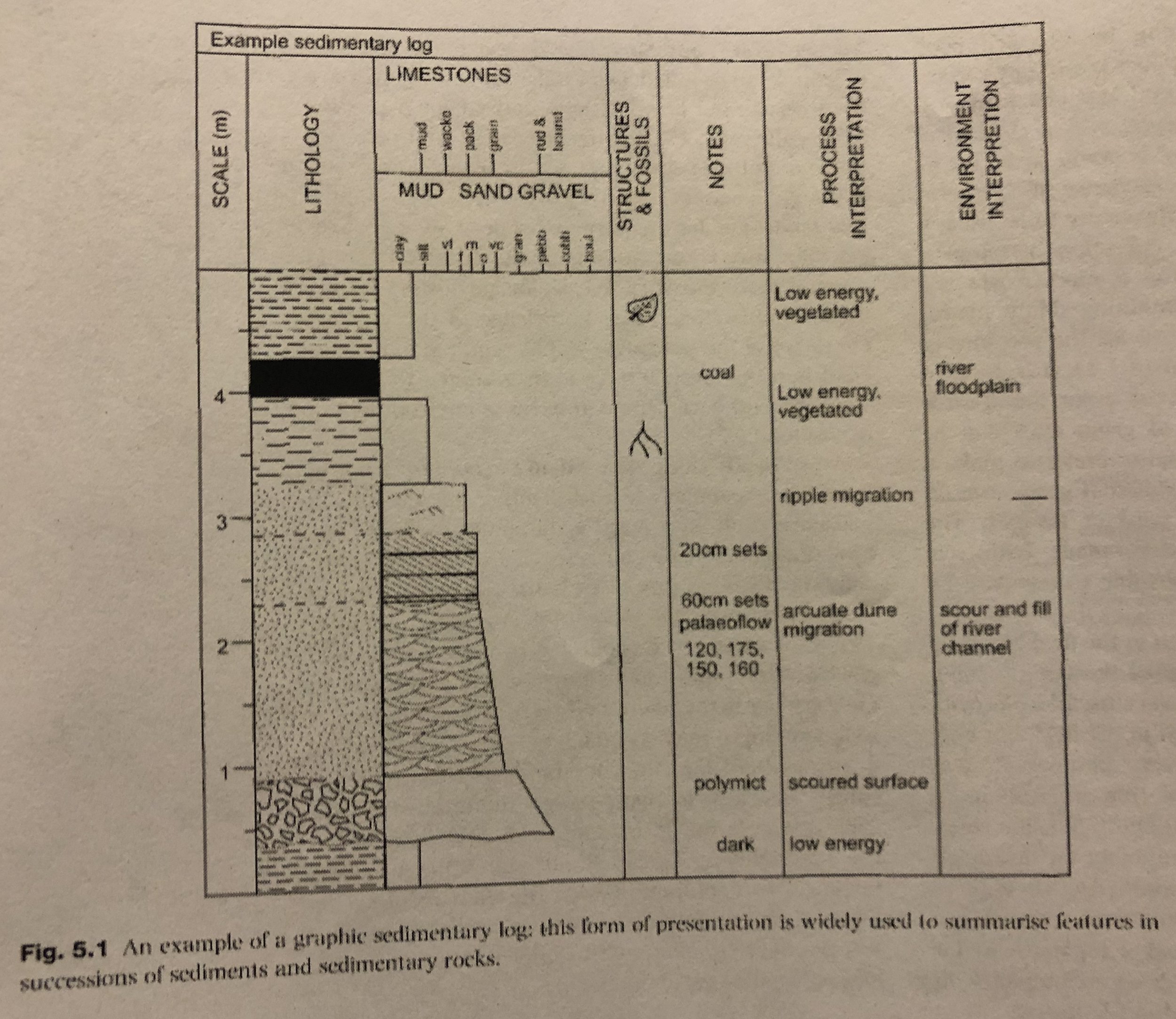
Bed: A single layer of sediment or sedimentary rock with a recognizable top and bottom.
Bedding Plane: The boundary between rock beds.
Strata: Several beds together.
Bedding (Stratification): The overall arrangement of sediment into a sequence of beds.
Lithification: The transformation of loose clasts into solid rock; takes place in two stages.
1) Compaction: The weight of overburden squeezes air or water out from between grains, so the grains can fit together more tightly.
2) Cementation: When minerals (commonly quartz or calcite) precipitate from groundwater and fill the remaining spaces between clasts, to form a cement that binds grains together.
Sedimentary Rock Structures
Joint: Natural crack in a rock.
Talus: Rock rubble at the base of a slope.
Floodplain: The flat land on either side of the river that water covers only during floods.
Subsidence: The process by which the surface of the lithosphere sinks.
Sedimentary Basin: A sediment-filled depression.
Rift Basin: Form in continental rifts, regions where the lithosphere is stretching horizontally, and therefore thins vertically.
Passive-Margin Basins: Form along the edges of continents that are not plate boundaries.
Intracontinental Basins: Develop in the interiors of continents, initially because of subsidence over a rift.
Foreland Basins: These form on the continental side of a mountain belt because the forces produced during convergence or collision push large slices of rock up faults and onto the surface of the continent.
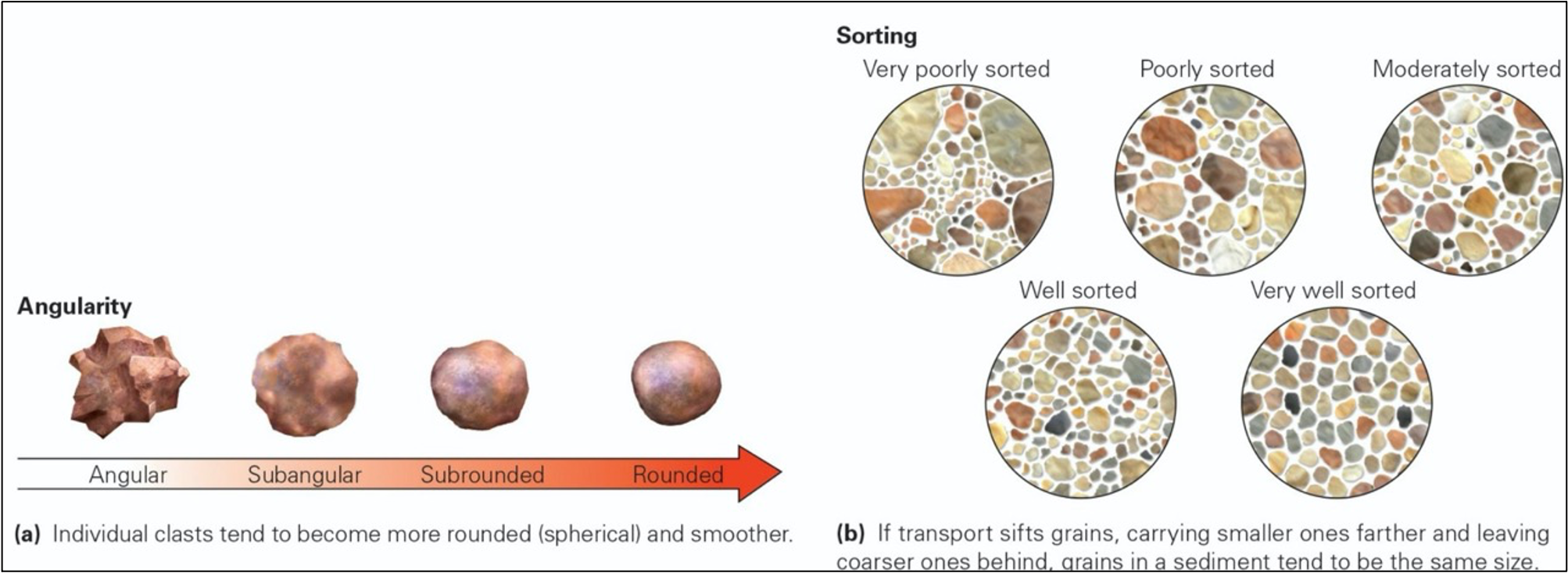
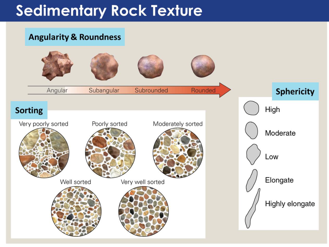
Sedimentary Rock Characteristics: Clast size, angularity, sphericity, sorting.
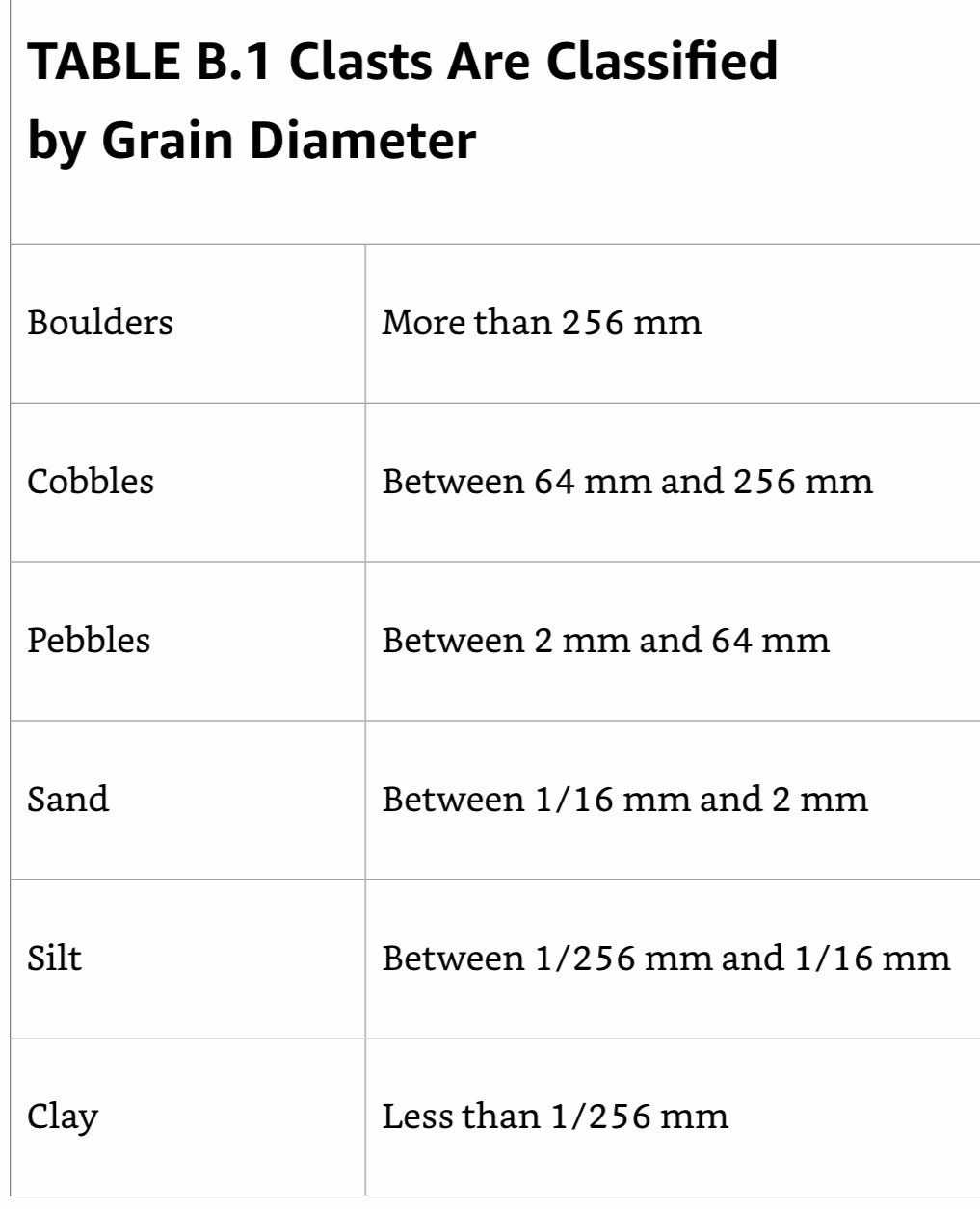
Clast Size: The diameter of fragments or grains making up a rock. The names used for clast size, listed in order from coarsest to finest, are: boulder, cobble, pebble, sand, silt, and mud.
Composition: The makeup of clasts in sedimentary rock. Clasts may be composed of rock fragments or individual mineral grains. Sand typically consists mostly of quartz grains.
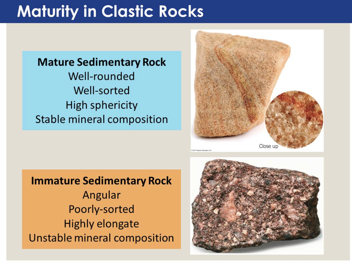
Angularity: The degree to which clasts have smooth surfaces, or have sharp corners and edges
Sphericity: How closely the shape of a clast resembles a sphere.
Sorting: Indicates the proportion of clasts in a rock that are the same size. Well-sorted sediment consists entirely of clasts that are the same size, whereas poorly sorted sediment contains a mixture of clast.
___________________________________________________________________
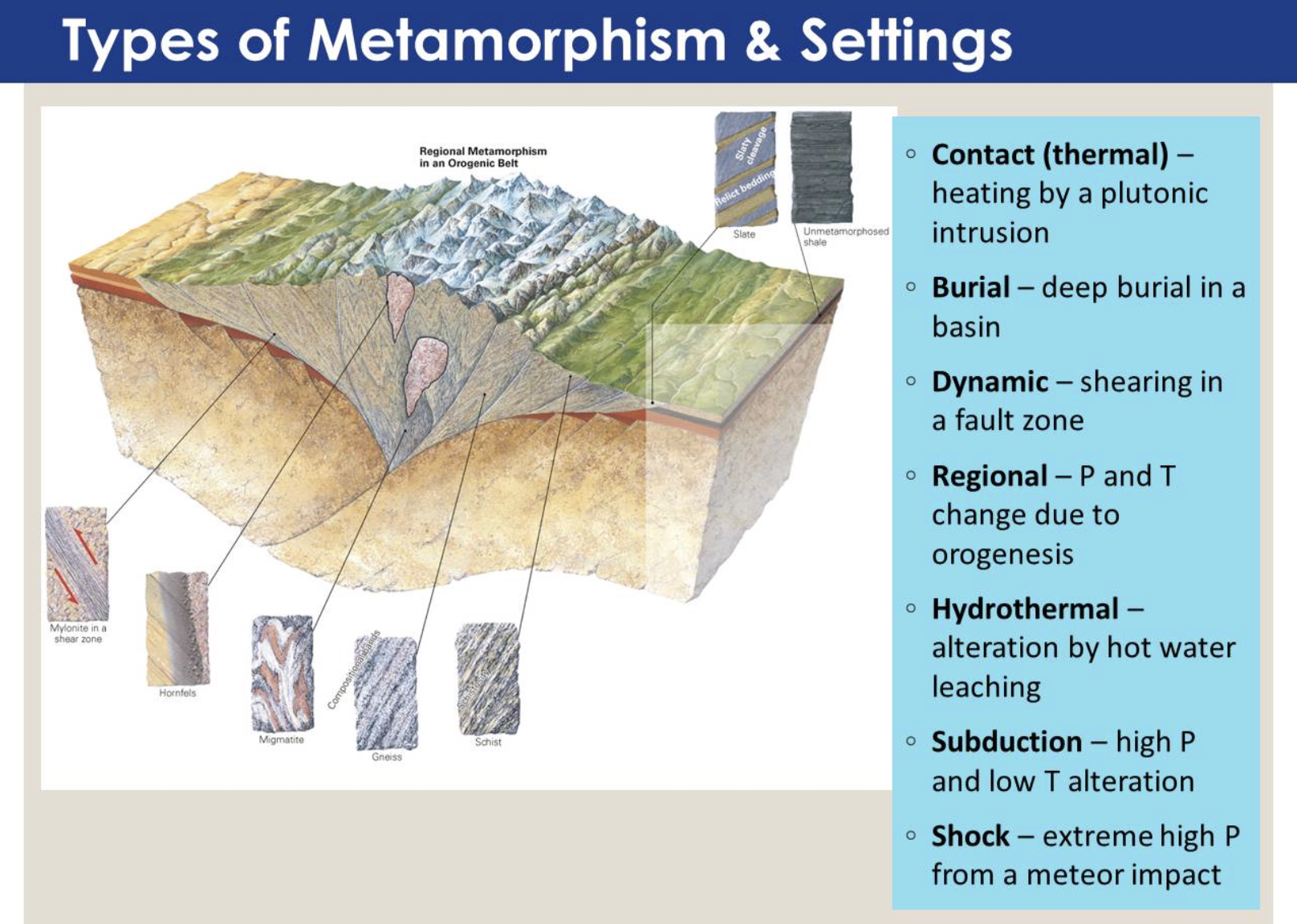
Ch 7: Metamorphism: A Process of Change
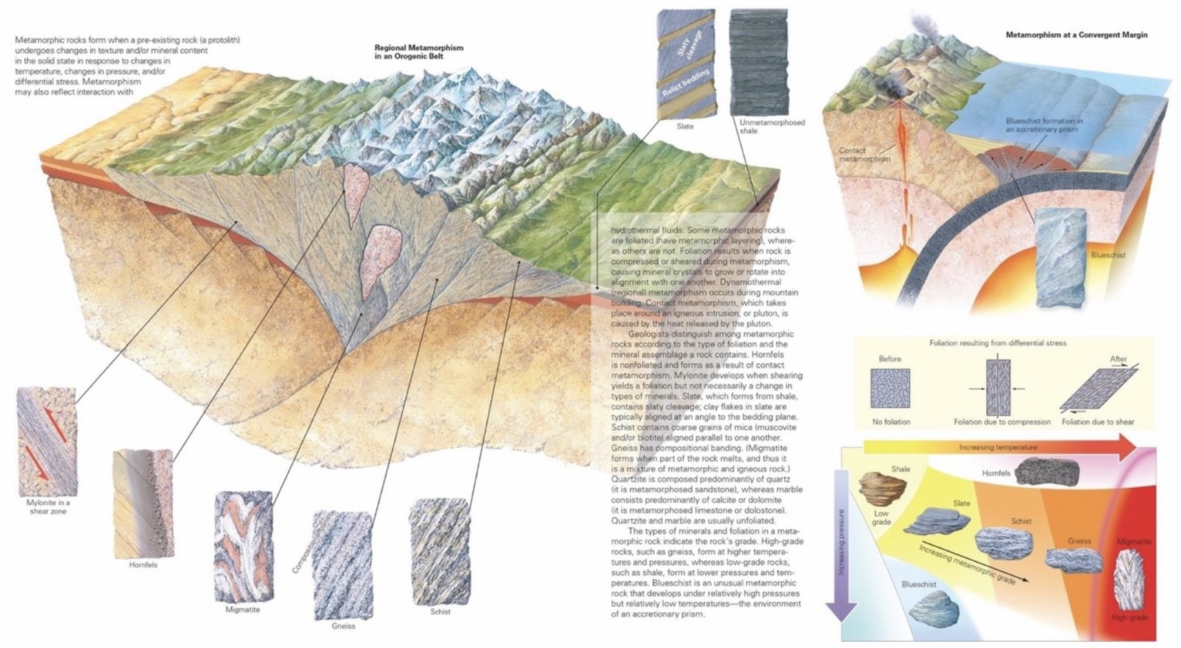
Metamorphic Rock: Rock that forms when preexisting rock changes into new rock as a result of an increase in pressure and temperature and/or shearing under elevated temperatures.
Protolith: The original rock from which a metamorphic rock formed.
Metamorphism: The process by which one kind of rock transforms into a different kind of rock.
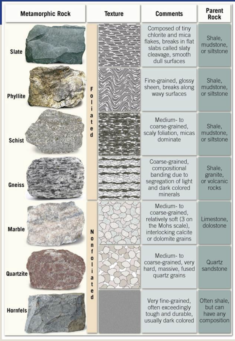
Metamorphic Rock Types; based on whether the rock contains foliation
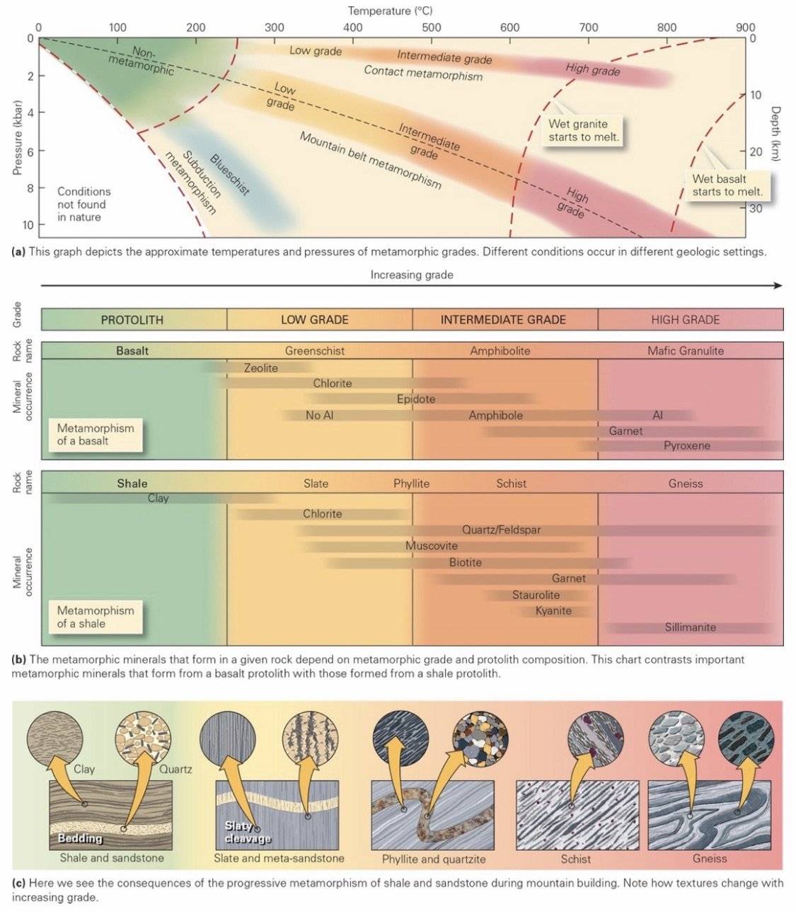
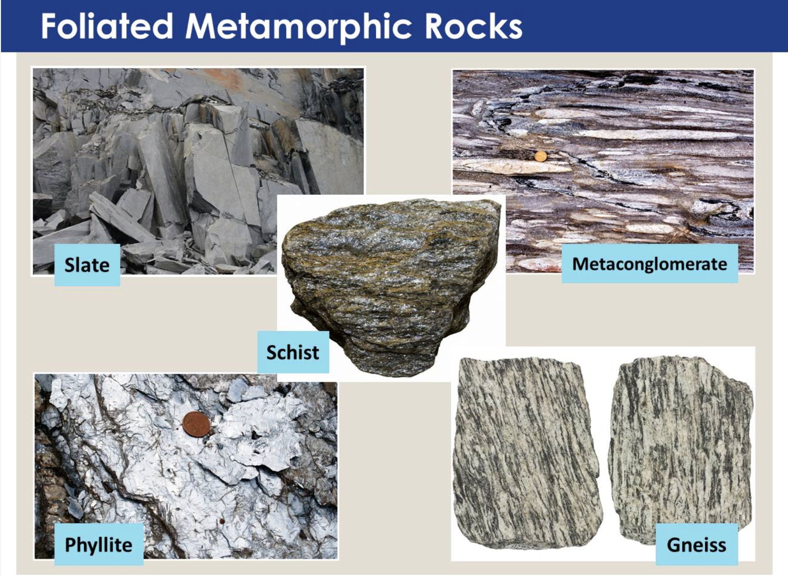
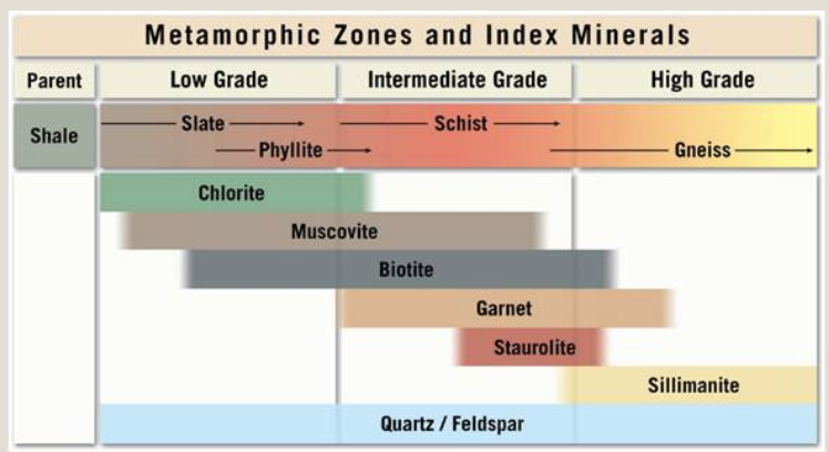
Foliated Rocks: Distinguished from one another according to their composition, grain size, and nature of foliation; include slate, schist, and gneiss.
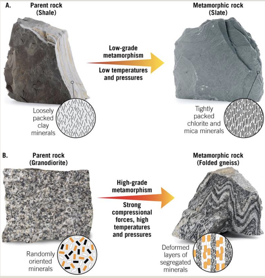
Slate: The finest-grained foliated metamorphic rock; formed by the metamorphism of shale or mudstone (rocks composed predominantly of clay) at shallower depths (relatively low pressures and temperatures).
Phyllite: A fine-grained metamorphic rock with a foliation caused by the preferred orientation of very fine-grained white mica. Phyllite forms when slate undergoes metamorphism at a temperature high enough to cause neocrystallization and the growth of white mica.
Metaconglomerate: A metamorphic rock produced by metamorphism of a conglomerate; typically, it contains flattened pebbles and cobbles.
Schist: A medium- to coarse-grained metamorphic rock containing a type of foliation called schistosity. This fabric is defined by the preferred orientation of large mica flakes (typically, muscovite or biotite). Schist forms at a higher temperature than does phyllite, for under hotter conditions, mica crystals can grow larger.
Gneiss: A compositionally banded metamorphic rock typically composed of alternating dark- and light-colored layers. The former have a higher concentration of mafic minerals, whereas the latter have a higher concentration of felsic minerals; formed by metamorphism at greater depths.
Nonfoliated Rocks: Contain minerals that recrystallized or grew during metamorphism. The rock has no foliation, which means either that metamorphism occurred in the absence of compression or shear, or that most of the new crystals are equant; include hornfels, marble and quartzite.
Hornfels: Hornfels is a fine-grained nonfoliated rock that contains a variety of metamorphic minerals. The specific mineral assemblage in a hornfels depends on the composition of the protolith and on the temperature and pressure of metamorphism.
Quartzite: Most quartzite forms by the metamorphism of pure quartz sandstone. During metamorphism, pre-existing quartz grains recrystallize, yielding new, larger grains. In the process, the distinction between cement and grains disappears, open pore space disappears, and the grains become interlocking. When quartzite fractures, cracks cut across grain boundaries—in contrast, cracks in a sandstone curve around grains. Quartzite looks glassier than sandstone and does not have the grainy, sandpaper-like surface characteristic of sandstone. Quartzite can be white, gray, maroon, or green, depending on the impurities it contains.
Marble: The metamorphism of limestone yields marble. During the formation of marble, calcite of the protolith recrystallizes, so fossil shells, pore space, and the distinction between grains and cement disappear. Therefore, marble typically consists of a fairly uniform mass of interlocking calcite crystals.
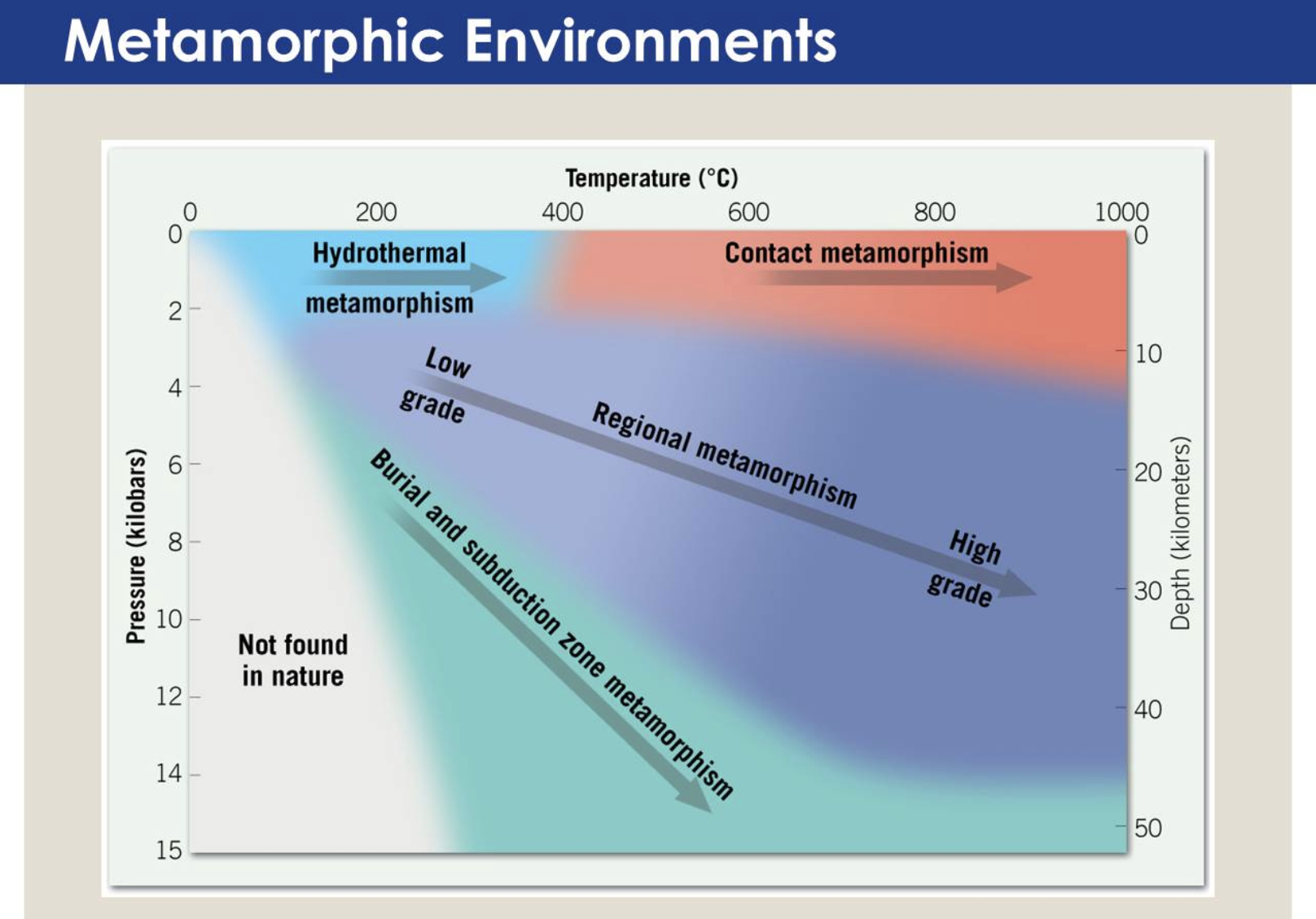
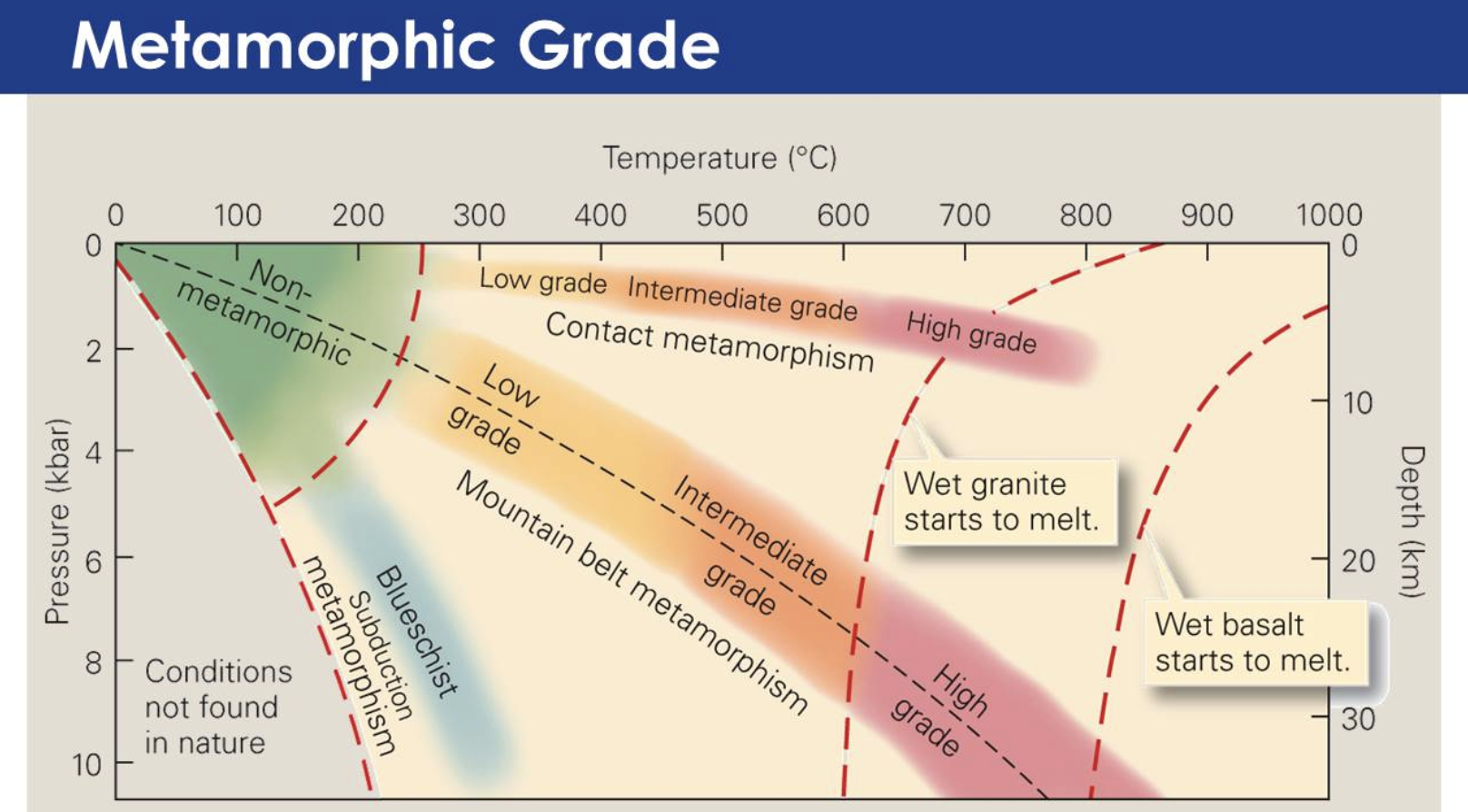
Metamorphism: The process by which one kind of rock transforms into a different kind of rock; occurs at temperatures between those at which diagenesis (sedimentary rock formation) occurs and those that cause melting; most metamorphic rocks form at temperatures between 250°C and 850°C.
Temperature plays the dominant role in determining the extent of recrystallization and neocrystallization that take place during metamorphism. Metamorphic rocks that form at relatively low temperatures (between about 250°C and 400°C) are low-grade rocks, and metamorphic rocks that form at relatively high temperatures (over about 600°C) are high-grade rocks. Intermediate-grade rocks form at temperatures between these two extremes. As grade increases, recrystallization and neocrystallization tend to produce coarser grains and new mineral assemblages that are stable at higher temperatures and pressures.
Contact Metamorphism: Develops adjacent to the contact between an intrusion with its wall rock. Because such metamorphism takes place without application of differential compression or shear, aureoles typically contain hornfels, a nonfoliated metamorphic rock. Contact metamorphism occurs anywhere that plutons intrude into the crust. In the context of plate tectonics theory, plutons intrude at convergent boundaries, in rifts, and during mountain building, so thermal metamorphism can occur in these settings.
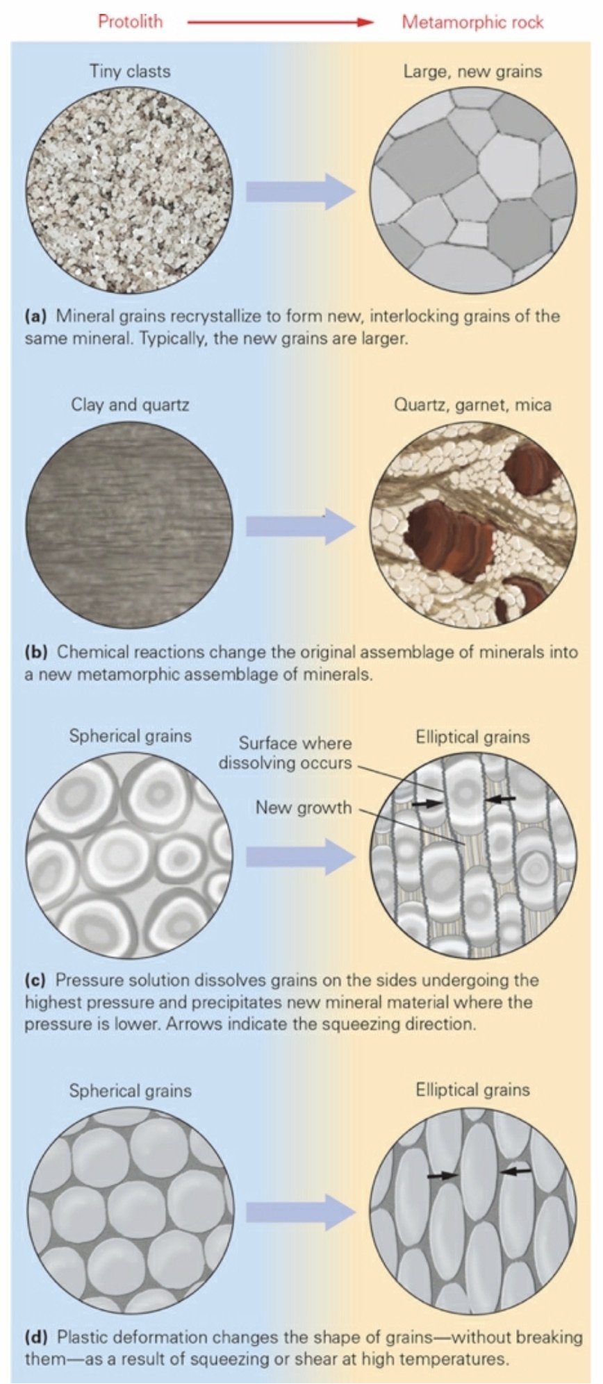
Recrystallization: Changes the shape and size of grains without changing the identity of the mineral making up the grains.
Metamorphic Reaction (‘Neocrystallization’): Results in growth of new minerals that differ from those of the protolith. During neocrystallization, chemical reactions digest minerals of the protolith and cause new minerals to grow.
Phase Change: Transforms one mineral into another mineral (a polymorph) with the same composition but a different crystal structure.
Pressure Solution: Occurs when the surface of one mineral grain pushes against the surface of another, under conditions where a water film separates the grains. The grains preferentially dissolve at the surface of contact, and the resulting ions migrate away
Plastic Deformation: Occurs when a rock becomes warm enough to behave like soft plastic, so the minerals within it can change shape without breaking.
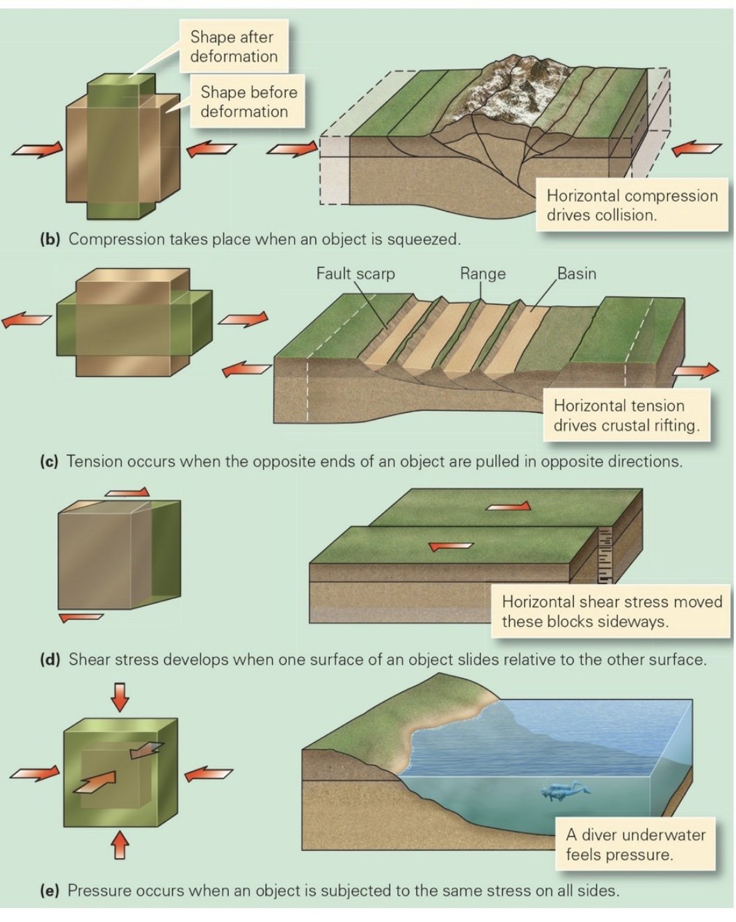
Normal Stress: Pushes (compressions) or pulls (tensions) perpendicular to a surface
Shear Stress (Shear): Moves one part of a material sideways relative to another part.
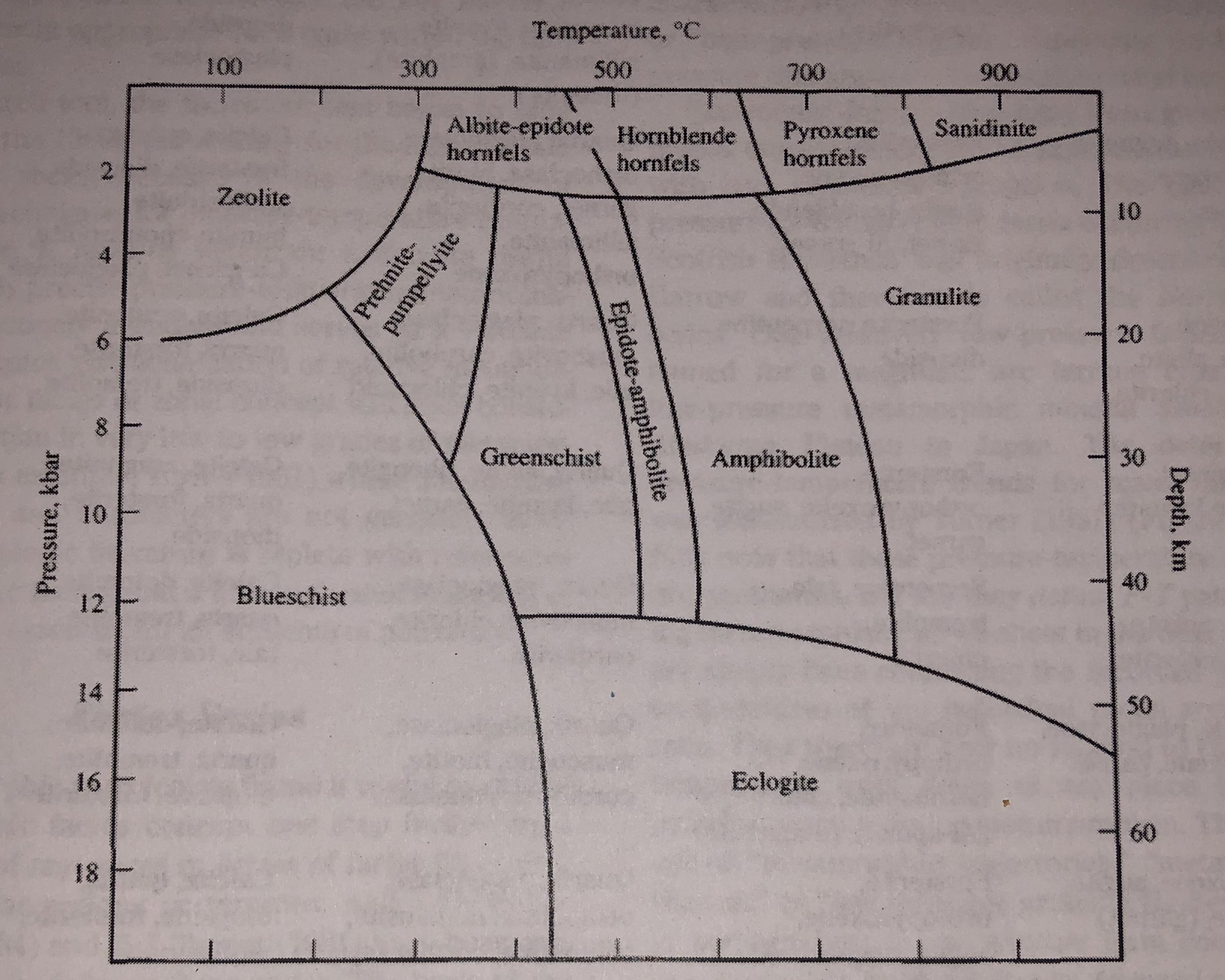
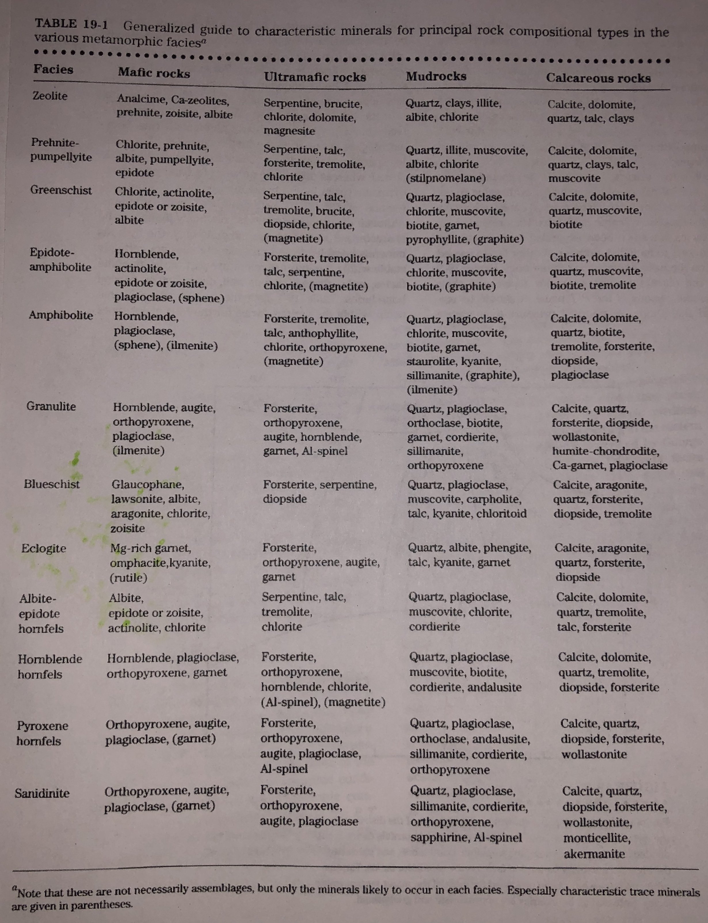
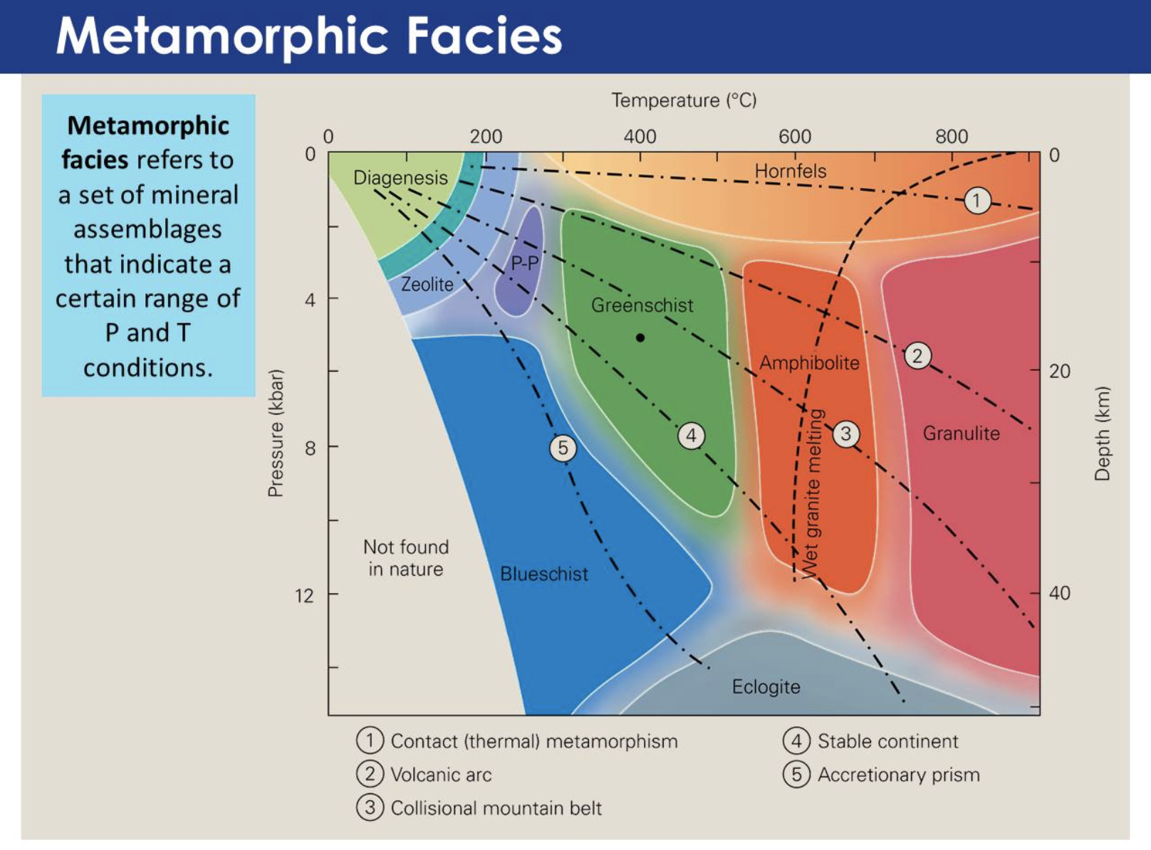
Metamorphic Facies: A set of metamorphic mineral assemblage’s indicative of a certain range of pressure and temperature. Each area of the graph, labeled with a facies name, represents the approximate range of temperatures and pressures in which mineral assemblage’s characteristic of that facies grew.
Porcelain: To produce porcelain—fine china—the clay must be heated to even higher temperatures, up to 1,400°C, for under these conditions the clay begins to melt. If the potter cools the slightly molten clay quickly, glass forms, which gives porcelain its translucent, vitreous appearance.
Kaolinite: Fine potter’s clay for making white china contains a particular clay mineral called kaolinite, named after Kauling, a locality in China where it was originally discovered.
Migmatite: A mixture of igneous and metamorphic rock; under high temperatures in the presence of water, gneiss may begin to melt, producing felsic magma and leaving behind solid, relatively mafic metamorphic rock. If the melt freezes again before flowing out of the source area, a mixture called migmatite, consisting of igneous rock and relict metamorphic rock, forms.
Hot magma rises beneath the axis of a mid-ocean ridge, so when cold seawater sinks down into the oceanic crust through cracks along the ridge, it heats up and transforms into hydrothermal fluid. This fluid then rises through the crust, near the ridge, causing hydrothermal metamorphism of ocean-floor basalt. Eventually, the fluid escapes through vents back into the sea at black smokers.
___________________________________________________________________
Interlude C: The Rock Cycle
___________________________________________________________________
Ch 8: Earthquakes
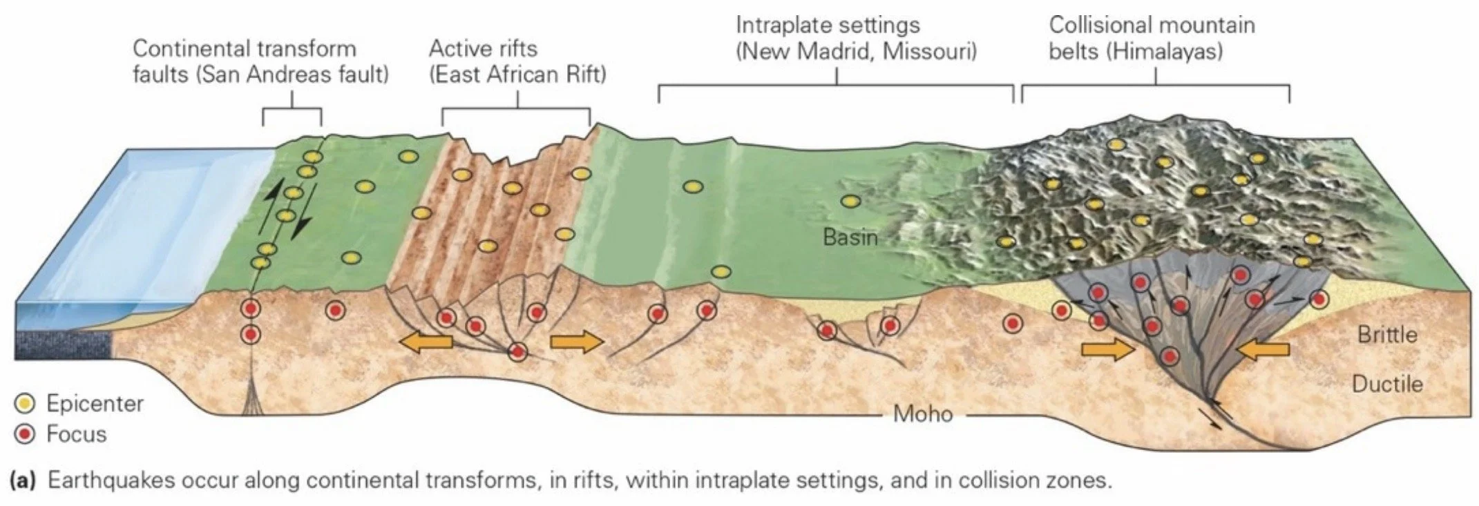
Most catastrophic earthquakes occur at convergent boundaries, or along continental transforms. Events also occur in rifts and collision zones, and along weak faults within plate interiors.
Geophysics: A subdiscipline of geoscience that focuses on the study of seismic waves, magnetism, gravity, and other physical characteristics of the Earth.
During fault formation, rock bends elastically, then cracks. Eventually, cracks link to form a throughgoing fracture on which sliding occurs. When this happens, the elastic rebound generates vibrations (an earthquake).
Once formed, faults exhibit stick-slip behavior. Most earthquakes happen when stress overcomes friction on a pre-existing fault.
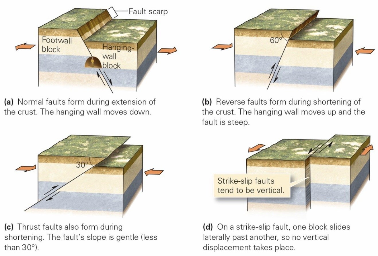
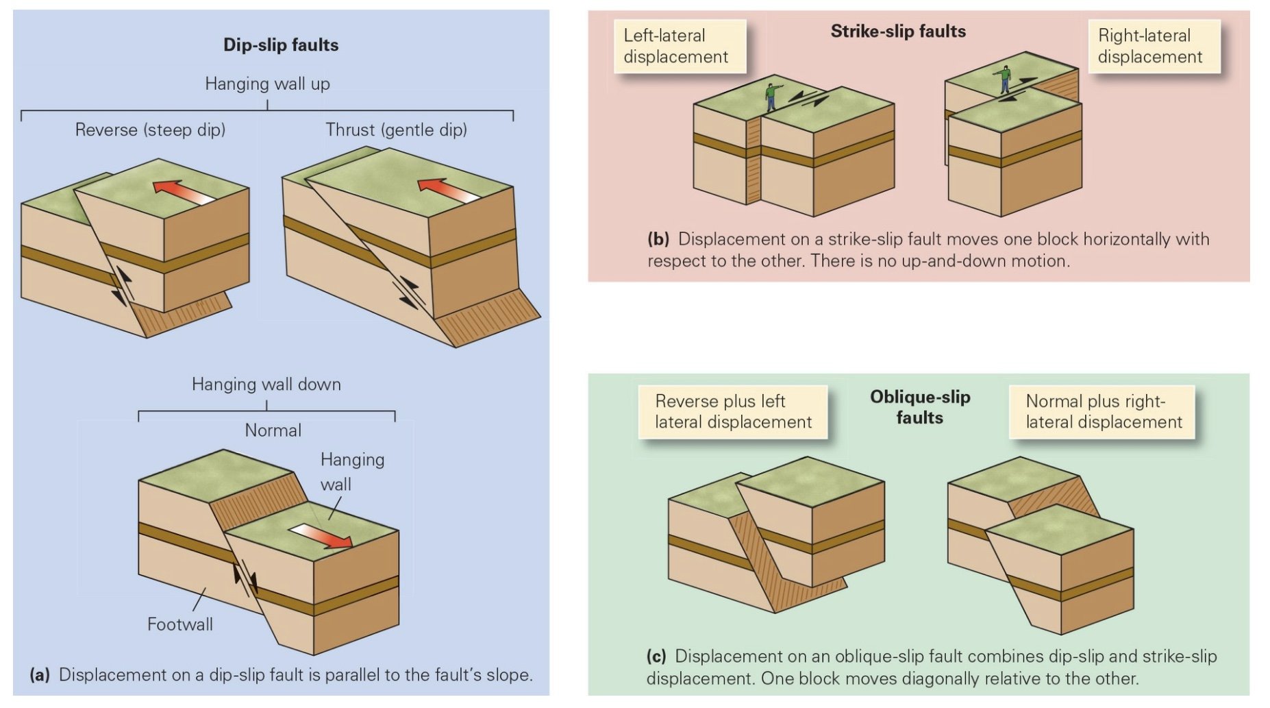
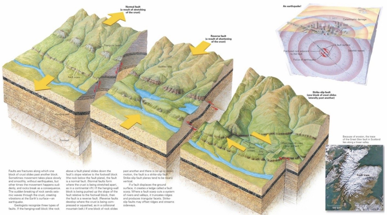
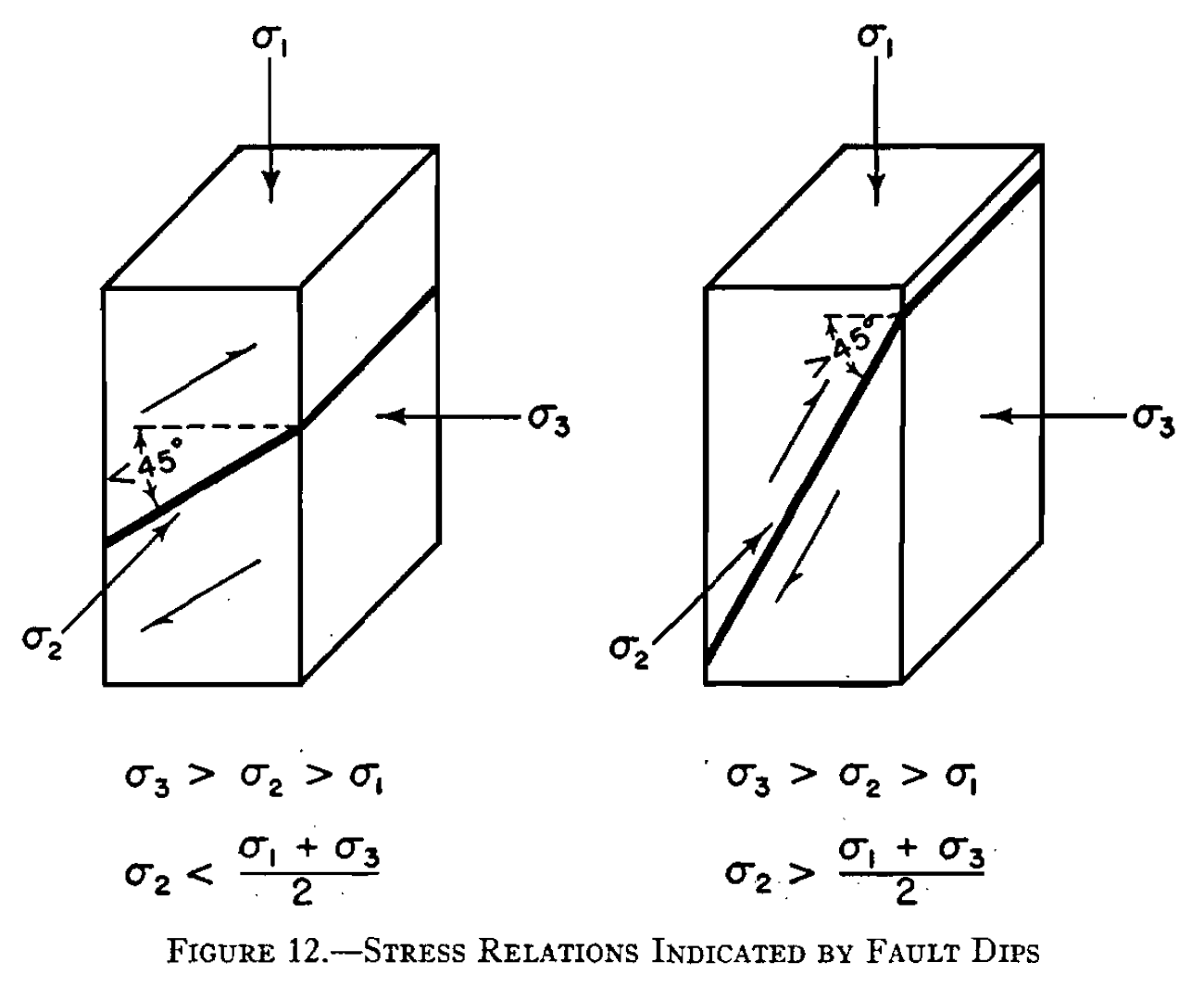
Fault: A fracture plane on which sliding occurs, and slip events, or faulting, can generate earthquakes. Fault classification focuses on two characteristics: 1) the dip or slope of the fault surface—the dip can be vertical, horizontal, or any angle in between; and 2) the shear sense across the fault—material on one side of the fault moves relative to the material on the other side.
Dip-Slip Faults: A fault in which movement parallels the dip line, a line going down the slope of the fault surface. Therefore, the hanging-wallblock, meaning the material above the fault surface, slides up or down relative to the footwall block, the material below the fault surface.
Reverse Fault: The hanging-wall block slides up, accommodating shortening of the crust, as happens during continental collision.
Thrust Fault: A reverse fault with a gentle dip (< 30°).
Normal Fault: The hanging-wall block slides down, accommodating a stretching of the Earth’s crust, as happens during rifting.
Strike-Slip Faults: A fault on which the slip direction is parallel to a horizontal line on the fault surface (the strike line. This means that the block on one side of the fault slips sideways, relative to the block on the other side, and there is no up-or-down motion. Most strike-slip faults have a steep to vertical dip. Geologists distinguish between two types of strike-slip faults based on the shear sense as viewed when you are facing the fault and looking across it. If the block on the far side slipped to your left, the fault is a left-lateral strike-slip fault, and if the block slipped to the right, the fault is a right-lateral strike-slip fault. Displacement at a transform plate boundary is accommodated by movement on strike-slip faults.
Oblique-Slip Faults: A fault in which sliding occurs diagonally on the fault plane; a combination of a strike-slip and a dip-slip fault.
Fault Topography
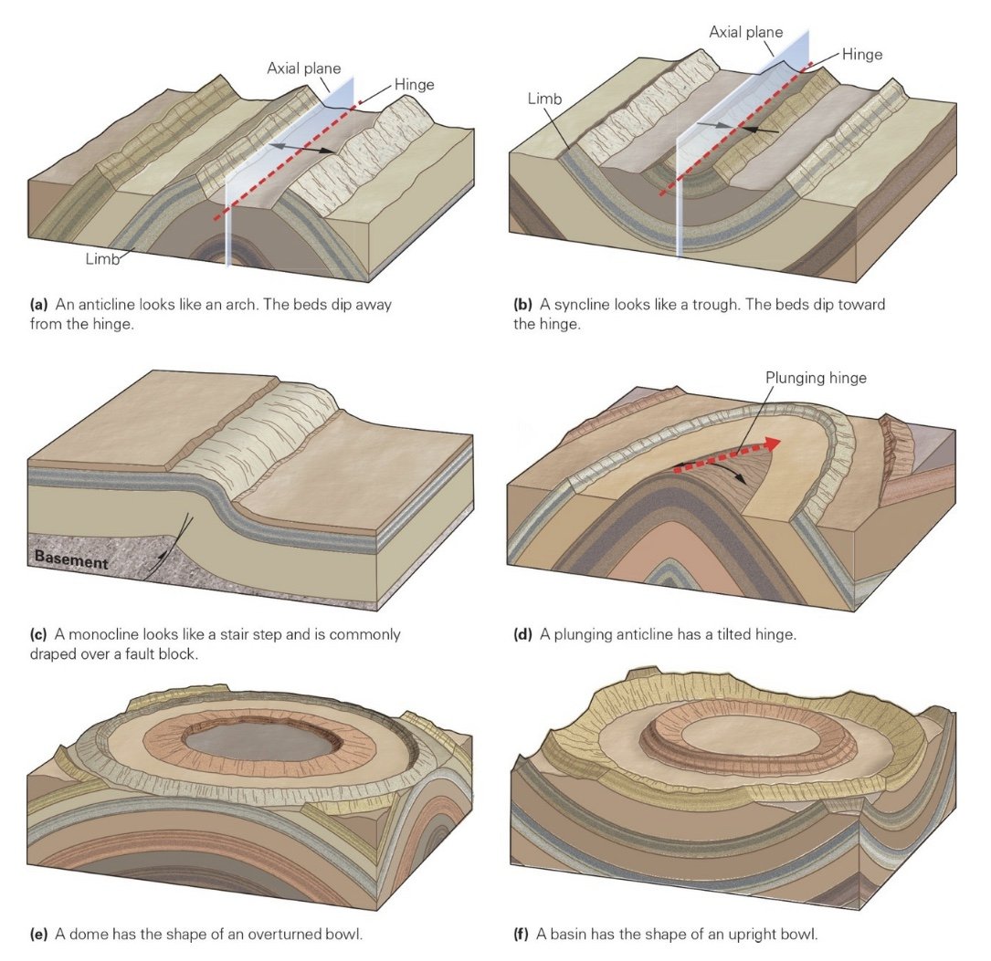
Anticlines: Folds that have an arch-like shape in which the limbs dip away from the hinge.
Synclines: Folds with a trough-like shape in which the limbs dip toward the hinge.
Monoclines: Folds that looks like the shape of a carpet draped over a stair.
Nonplunging Fold: A fold with a horizontal hinge.
Plunging Fold: A fold with a plunging (tilted) hinge.
Dome: A fold with the shape of an overturned bowl; appear as a bullseye on a topo map.
Basin: A fold with the shape of an upright bowl; appear as a bullseye on a topo map.
Earthquakes: Occurs when masses of rock suddenly vibrate. The energy released by this process travels away from the source in the form of seismic waves or earthquake waves, that can reach and shake the surface of the Earth. An earthquake can happen when a new fault forms by rupturing previously intact rock or when a pre-existing fault suddenly slips again.
Elastic Rebound Theory of Earthquake Generation: Earthquakes happen because stresses build up, causing rock to develop elastic strain until either intact rock breaks or a pre-existing fault reactivates. When slip takes place, the once-bent rocks adjacent to the fault rebound and vibrate back and forth until they regain their relaxed shape, thereby relieving the elastic strain.
Foreshocks: Smaller earthquakes that precede a major earthquake. These possibly result from the development or propagation of smaller cracks in the vicinity of what will be the major fault.
Aftershocks: Smaller earthquakes that occur after the main earthquake because slip during the mainshock does not leave the fault in a perfectly stable configuration. For example, after the mainshock, bumps on one side of the fault surface may, in their new position, push so hard into the opposing side that they generate new stresses that are large enough to cause a small portion of the fault around the bump to slip again, or to cause slip on a nearby fault.
Stick-Slip: Alternations between stress buildup and earthquake-generating slip events.
Shallow-Focus Earthquakes: Occur in the top 60 km of the Earth’s crust.
Intermediate-Focus Earthquakes: Occur at depths between 60-300km.
Deep-Focus Earthquakes: Occur down to a depth of about 660 km. Earthquakes do not happen below 660 km.
Displacement (offset): The amount of movement or slip across a fault plane.
Intraplate Earthquakes: Earthquakes that occur away from plate boundaries.
Earthquake Topography
Epicenter: The point on the surface of the Earth that lies directly above the focus as the earthquake’s epicenter.
Focus (aka Hypocenter): The location where the slip begins and seismic waves are first generated.
Fault Scarp: A small step on the ground surface where one side of a fault has moved vertically with respect to the other.
Wadati-Benioff Zone: A sloping band of seismicity defined by intermediate- and deep-focus earthquakes that occur in the downgoing slab of a convergent plate boundary.
Earthquake Waves: Body and Surface Waves.
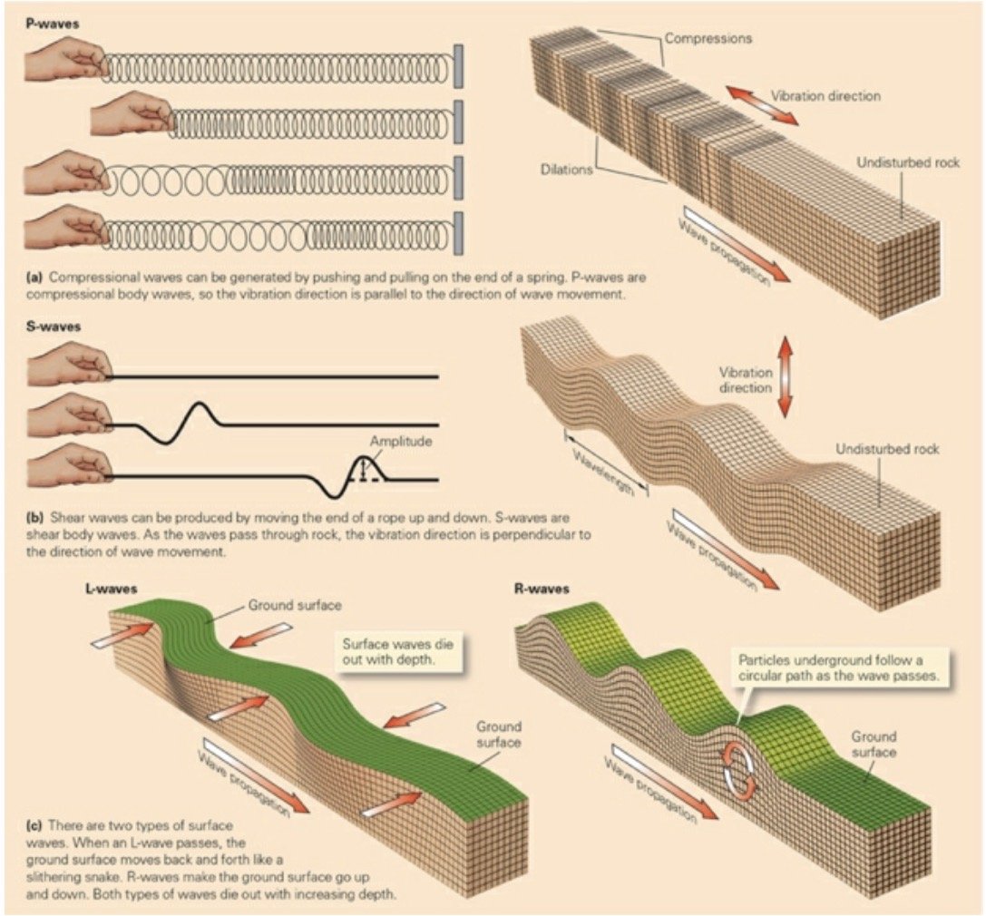
Body Waves: Cause a material to vibrate in two different ways: 1) compressional waves cause particles of material to move back and forth parallel to the direction in which the wave itself moves. As a compressional wave passes, the material first compresses (squeezes together), then dilates (expands). To see this kind of motion in action, push on the end of a spring and watch as the little pulse of compression moves along the length of the spring. 2) Shear waves cause particles of material to move back and forth perpendicular to the direction in which the wave itself moves. To see shear-wave motion, jerk the end of a rope up and down and watch how the up-and-down motion travels along the rope.
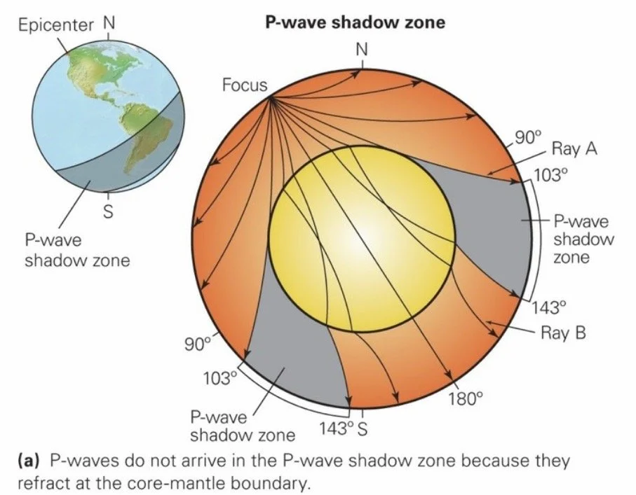
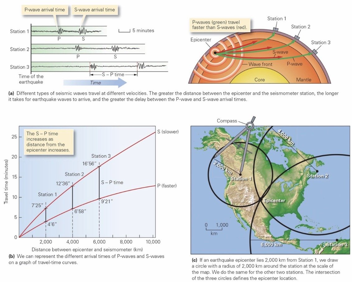
P-Waves (Primary): Compressional body waves that travel through both solids and liquids.
P-waves reaching distant seismometers had refracted at the crust-mantle boundary, and for part of their route they had passed through the mantle, in which they traveled relatively rapidly. Mohorovičić was able to calculate the depth of the crust-mantle boundary from this observation and proposed that, beneath continents, it occurred at a depth of about 35 to 40 km.
P-Wave Shadow Zone: P-waves from an earthquake do not arrive at seismometer stations lying in a band at a distance of between 103° and 143° from the epicenter, as measured along the surface of the Earth (Gutenberg, 1914).
S-Waves (Secondary): Shear body waves, travel only through solids. Seismologists have found that S-waves do not arrive at stations located beyond 103° from the epicenter, defining a band called the S-wave shadow zone. This means that S-waves cannot pass through the core at all.
Surface Waves: Vibrate in two different ways—some cause the ground surface to go up and down in rolling undulations, and some cause the surface to go back and forth sideways, like the movement of a snake.
L-Waves (Love): Surface waves that cause the ground to shimmy back and forth.
R-Waves (Rayleigh): Surface waves that cause the ground to undulate up and down.
Seismometers
The instant at which a seismic wave appears at a seismometer station is the arrival time of the wave. The first squiggles on the record represent P-waves, because P-waves travel the fastest. Next come the S-waves, and finally the surface waves (L-waves and R-waves).
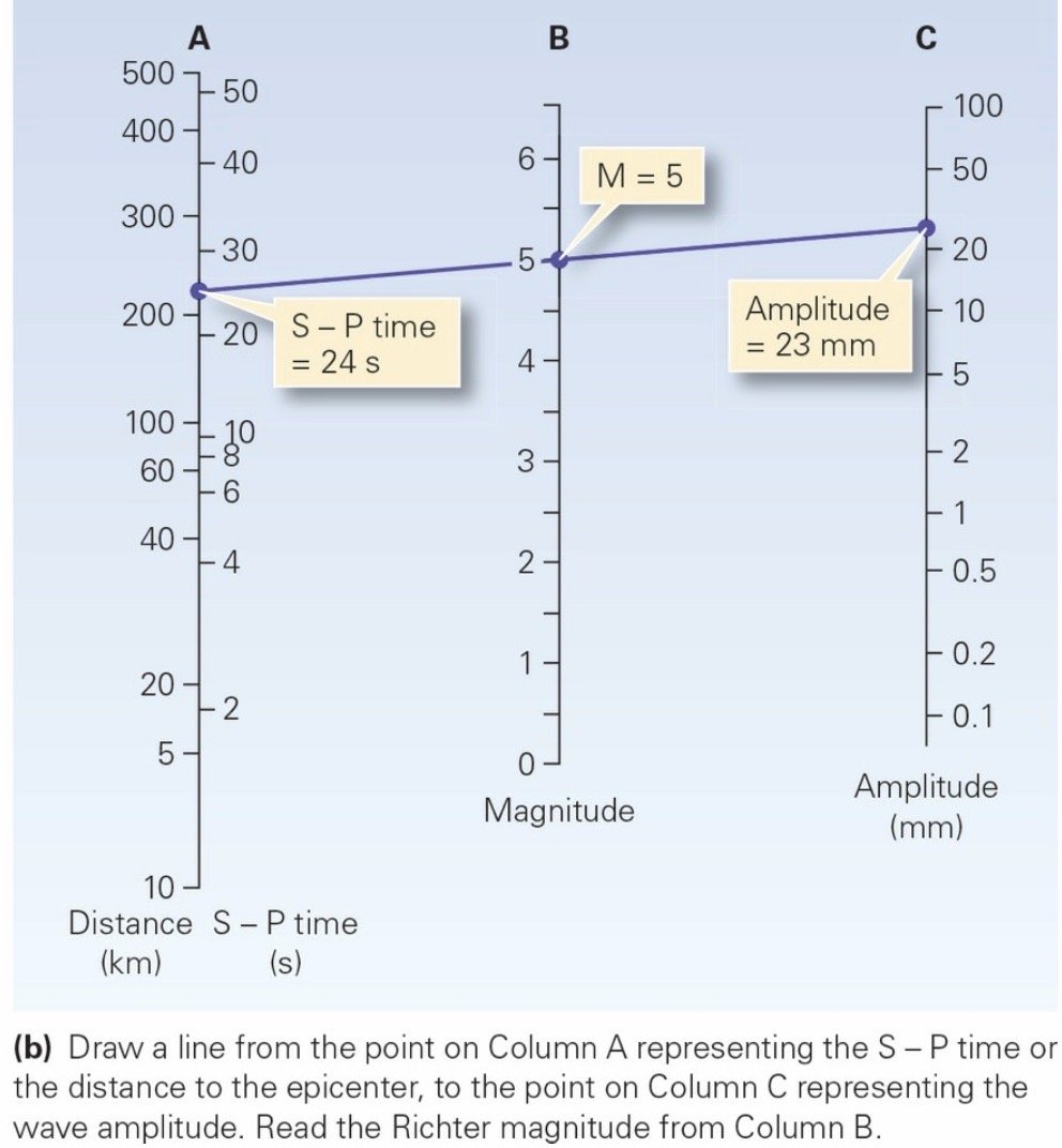
Measuring the difference between the P-wave arrival time and the S-wave arrival time provides an easy way to calculate the distance between the epicenter and a seismometer, for these waves are very distinctive. We can represent the time delay between P-waves and S-waves by depicting a travel-time curve on a graph whose horizontal axis indicates distance from the epicenter and whose vertical axis indicates time. The curve shows the increase in time that it takes for an earthquake wave to move from its origin to a seismometer station, as the distance between the epicenter and the seismometer station increases. Start by measuring the time difference between the P- and S-waves on a seismogram. This quantity is called the S – P (pronounced “S minus P”) time. Then draw a line segment on a piece of tracing paper to represent this amount of time, at the scale used for the vertical axis of the graph. Orient the line segment parallel to the time axis and move it back and forth until one end lies on the P-wave curve and the other end lies on the S-wave curve (this gives the S – P time). Extend the line down to the horizontal axis, and simply read off the distance to the epicenter from the seismic station.
In a modern electronic seismometer, the weight consists of a magnet that moves relative to a wire coil, thereby producing an electric signal that can be recorded digitally. Such seismometers are so sensitive that they can record ground movements of a millionth of a millimeter- movements that people can’t feel. Typically, seismologists place the instruments in an underground vault, preferably on bedrock, located away from traffic, urban noise, or swaying trees that could cause vibrations that are not due to earthquakes. The entire configuration comprises a seismometer station.
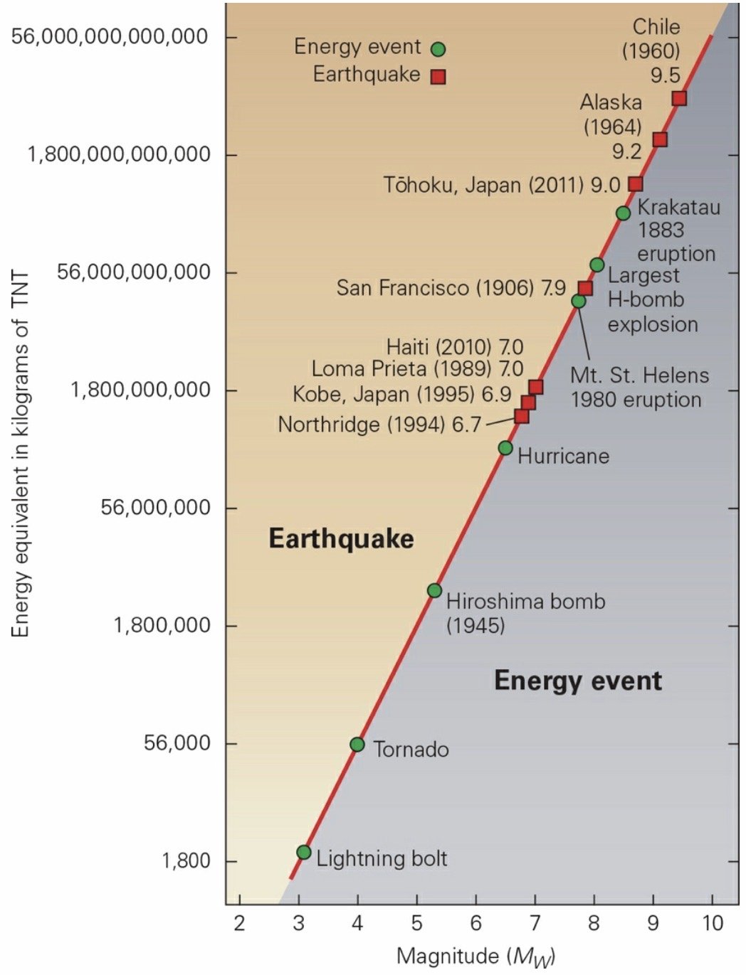
Earthquake Magnitude: The amount of energy released from the seismic source, as indicated by the amplitude of ground shaking recorded by a seismometer.
Earthquakes cause devastation in many ways. Ground shaking, landslides, sediment liquefaction, and tsunamis can topple buildings and disrupt the land. Fire and disease may follow.
Moment Magnitude Scale: A modern scale for measuring the relative size of earthquakes that involves studying the amplitude of waves on a seismograph, along with other parameters.
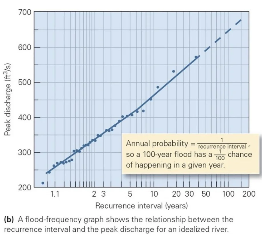
Earthquake Prediction: Seismologists base long-term earthquake predictions on two pieces of information: the identification of seismic belts and the recurrence interval.
Recurrence Interval: The average time between successive events of a specified size.
Earthquake Engineering: Designing buildings that can withstand shaking.
Earthquake Zoning: Determining where land is stable and where it is not.
Tsunamis
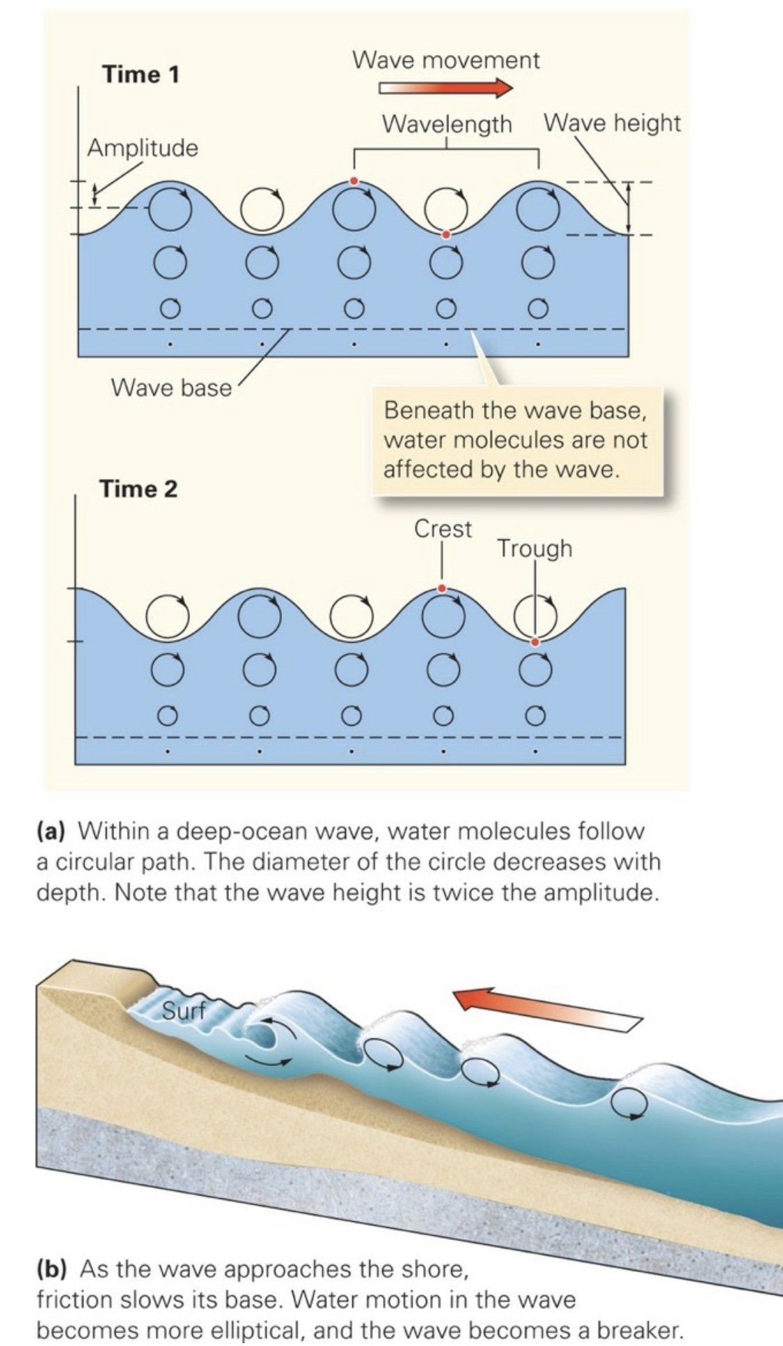
A tsunami in deep water may cause a rise in sea level of at most only a few tens of centimeters, which means a ship crossing one wouldn’t even notice, a tsunami has a wavelength of 10 to 500 km—so such a wave can involve a huge volume of water.
When any wave approaches the shore, friction between the base of the wave and the seafloor slows the bottom of the wave, so the back of the wave catches up to the front, and the added volume of water builds the wave higher. The top of the wave may fall over the front of the wave and produce a breaker. In the case of a wind-driven wave, the breaker may be tall when it crashes onto the beach, but because the wave doesn’t contain much water, it runs out of water and friction slows it to a stop on the beach. Gravity then causes the water to flow seaward, back down the beach. The width of a beach indicates the width of the coast affected by wave action. In the case of a tsunami, the wave is so wide that, as friction slows the wave, it builds into a plateau of water that can be many kilometers wide. If the tsunami is high—some are up to 30 m high—it can cross the beach, and if the land is low-lying, the tsunami can keep moving, eventually submerging a huge area. A smaller tsunami will probably affect only the near-shore area.
___________________________________________________________________
Interlude D: The Earth’s Interior
Magnetism
Chinese sailors discovered that a piece of lodestone, when suspended from a thread, points in a northerly direction and can help guide a voyage.
Fe is an electrical conductor, and flow of a conductor in the presence of a magnetic field generates an electric current.
The magnetic field has an inclination of 0° at the magnetic equator and 90° at the magnetic pole.
Magnetic Declination: The angle between the direction a compass needle points at a given location and the direction of true N.
Magnetic Inclination: The angle between a magnetic needle free to pivot on a horizontal axis and a horizontal plane parallel to the Earth’s surface.
Gravity Anomaly: A value of gravitational pull that deviates from the geoid’s reference spheroid.
The highest point on the geoid lies 85 m above the reference spheroid, and the lowest lies 107 m below.
Gravity pulls more strongly over a positive gravity anomaly and pulls less strongly over a negative gravity anomaly. A positive anomaly indicates that extra mass lies below the site, perhaps due to a body of particularly dense rock underground, whereas a negative anomaly means that a deficit of mass lies below the site,
A large negative gravity anomaly occurs over trenches at convergent plate boundaries. There, subducting plates are bent downward to a depth greater than where they would be if at isostatic equilibrium. The deep water over a trench has less density than rock, so it does not produce as much gravitational pull.
Positive gravity anomalies occur over continental rifts filled with thick successions of dense basalt layers, because the dense basalt produces a stronger gravitational pull than does the less-dense surrounding rock.
In order to maintain isostasy, addition of a load, such as growth of an ice sheet or building of a volcano, causes the lithosphere’s surface to sink, whereas removal of a load, say by melting of an ice sheet, causes the lithosphere’s surface to rise. But, since asthenosphere flows very slowly, isostasy can’t be achieved instantly. In addition, because the lithosphere has strength, it can support small, heavy loads in places, or keep relatively low-density materials from rising, without the surface of the lithosphere sinking or rising overall. Places on the Earth where isostasy does not exist are the places where we observe gravity anomalies.
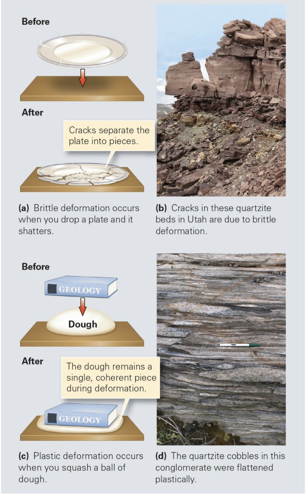
Deformation: The geological process which affects the shape, size, or volume of an area of the crust of the Earth. Influenced by the strength of the rock, temperature, confining pressure, rock type, and time.
Brittle Deformation: The cracking and fracturing of a material subjected to stress.
Plastic Deformation: The deformational process in which mineral grains behave like plastic and, when compressed or sheared, become flattened or elongate without cracking or breaking.
Brittle-Plastic Transition: Rocks generally behave brittlely above a depth of about 10 to 15 km and plastically below this depth.
Warmer rocks tend to deform plastically, whereas colder rocks tend to deform brittlely.
Under great pressures deep in the Earth, rock behaves more plastically than it does under low pressures near the surface.
A sudden change in shape causes brittle deformation, whereas a slow change in shape can cause plastic deformation.
Vein: A mineral filled crack; occurs if groundwater or hydrothermal fluids seep through cracks in rocks, minerals such as quartz or calcite may precipitate out of the groundwater and fill the cracks.
Deformation Forces
Stress: The push, pull, or shear that a material feels when subjected to a force; formally, the force applied per unit area over which the force acts. Stress causes strain (the shape of a rock).
Compression: Causes shortening of a rock.
Tension: Causes plastic deformation.
___________________________________________________________________
Ch 9: Mountain Building
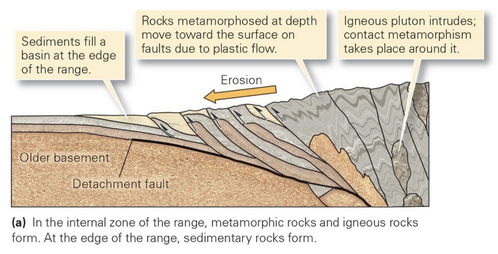
Mountain belts form in association with convergence, collision, and rifting. During convergent and collisional orogeny, continental crust thickens, large thrust faults and folds form, and regional metamorphism develops. Rifting yields fault-block mountains, separated by narrow basins.
The elevation of the top surface of the lithosphere, over a broad region, represents a balance between buoyancy force pushing lithosphere up and gravitational force pulling the lithosphere down.
Uplift in mountains, over broad regions, is controlled by isostasy, meaning that the elevation of the Earth’s surface reflects the level at which lithosphere naturally rests on the asthenosphere.
Collision
During collision, intense compression generates fold-thrust belts on the margins of the orogeny. In the interior of the orogen, where one block overrides the edge of the other, high-grade metamorphism occurs, accompanied by formation of passive-flow folds and tectonic foliation.
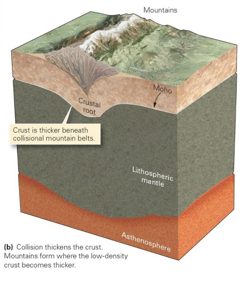
During collisional orogeny or during certain types of convergent-margin orogeny, horizontal compression causes the crust to shorten horizontally and thicken vertically. To isostatically compensate for the thickening of the crust, the geologic equivalent to adding another block of low-density wood to the top of a floating block, the base of the crust and underlying lithospheric mantle sink, or subside. For example, continental crust is about 70 km thick, almost twice its normal thickness, beneath the Himalayas. Because the Himalayas rise about 8 km above sea level, most of the thickened crust extends downward beneath the range just as most of a floating ice cube is underwater. This downward protrusion of crust is called a crustal root.
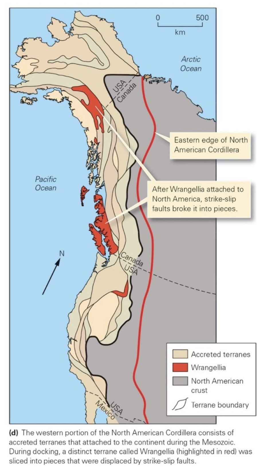
Accretion: The process of building out a continent by attaching new crustal fragments.
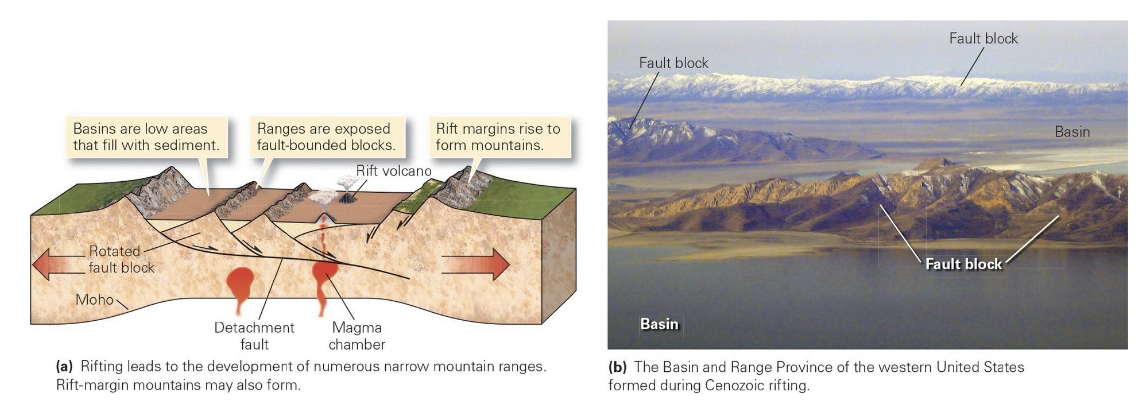
Rifting
During rifting, tensional stress causes normal faulting in the upper crust.
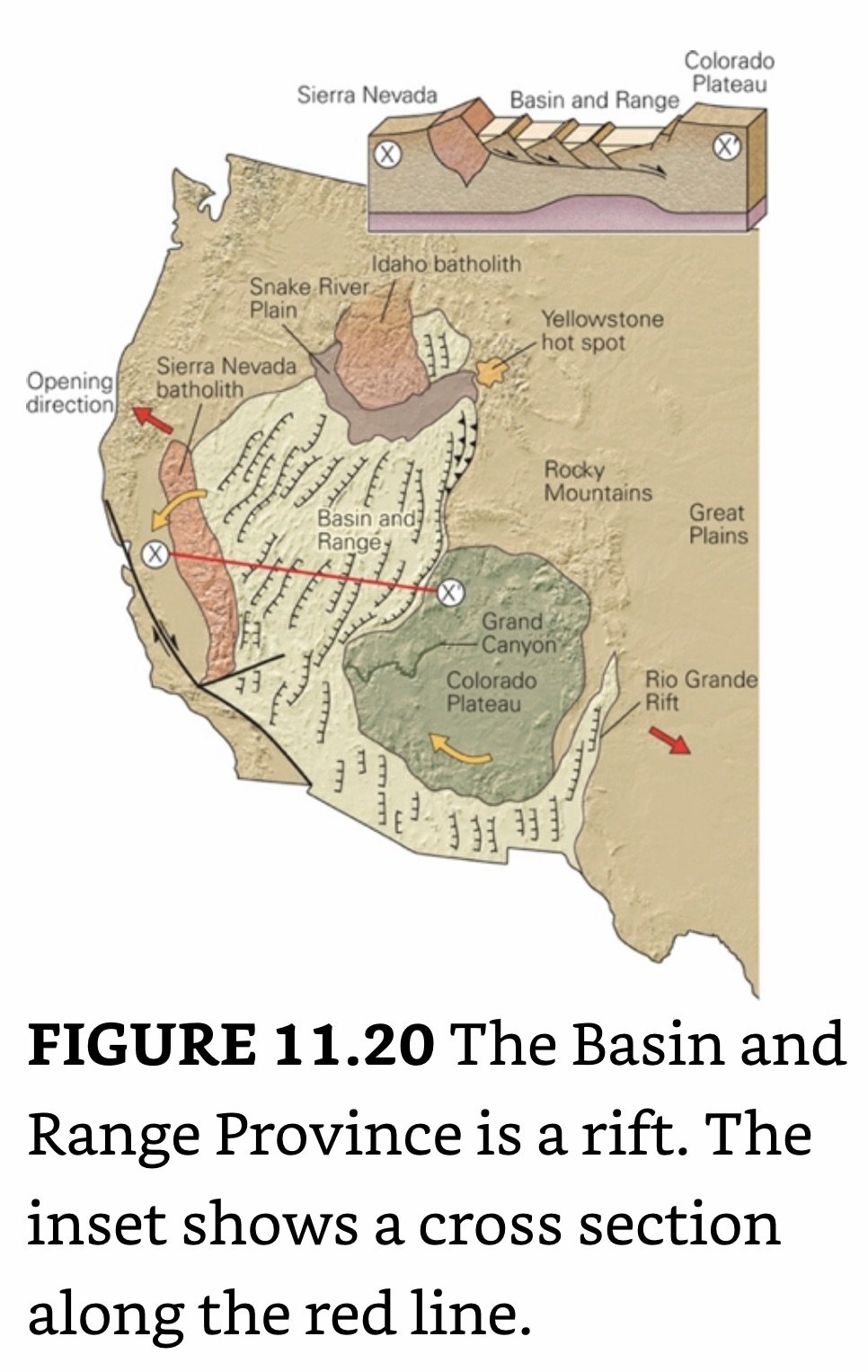
In North America, rifting yielded the broad Basin and Range Province of UT, NV, and AZ.
In rifts, the lithosphere undergoes stretching and thinning. As a result, relatively less-dense asthenosphere rises beneath the rift, and the remaining lithosphere heats up. Replacing denser lithospheric mantle with less-dense asthenosphere, together with heating the remaining thinned lithosphere (which causes the lithosphere to expand and become less dense), causes the overall region of the rift, as well as the margin of the rift, to rise in order to maintain isostasy.
Orogeny Characteristics
Orogenic Collapse: At the high temperatures that occur at depths of 10 to 30 km, quartz-rich crustal rocks become so weak that it is relatively easy for them to flow plastically. When this flow begins, overlying mountains effectively begin to collapse under their own weight and spread laterally. During orogenic collapse, the upper crust breaks and a system of normal faults develops to accommodate the horizontal stretching.
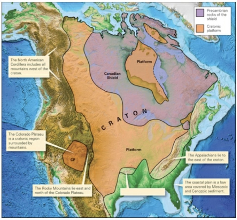
Craton: Crust that has not been affected by orogeny for at least about the last 1B years. Cratons are divided into shields and cratonic platforms.
Shields: Cratons where Precambrian metamorphic and igneous rocks crop out at the ground surface.
Cratonic Platforms: Cratons where a relatively thin layer of Phanerozoic sediment covers the Precambrian rocks.
___________________________________________________________________
Interlude E: Fossils and Evolution
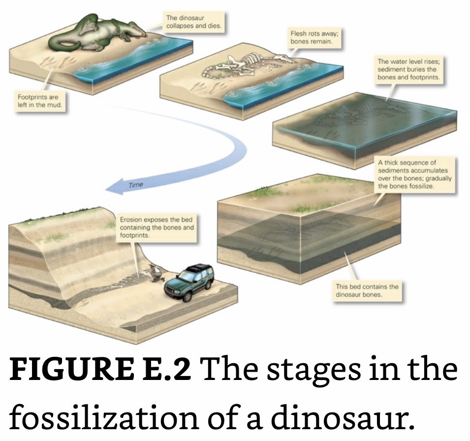
Fossils (Fossilis: Dig Up- Latin): The remnants or traces of ancient living organisms that were buried with the material from which the rock formed and were preserved after lithification.
Preservation Potential of Organisms: The likelihood that an organism will be buried and eventually transformed into a fossil.
If a carcass settles into an anoxic environment, oxidation occurs slowly, scavenging organisms are scarce, and bacterial metabolism takes place very slowly. In such environments, the organism will have a chance to be buried and preserved, so the likelihood increases that the organism will become fossilized.
Species: A distinct group of organisms capable of breeding.
Evolution: The progressive change over time in characteristics of species that has led to the appearance of new species.
Tar: Occurs in isolated regions where oil has seeped to the surface, the more volatile components of the oil evaporate away and bacteria degrade what remains.
Bones: The internal skeletons of vertebrate animals.
Shells: The external skeletons of invertebrate animals.
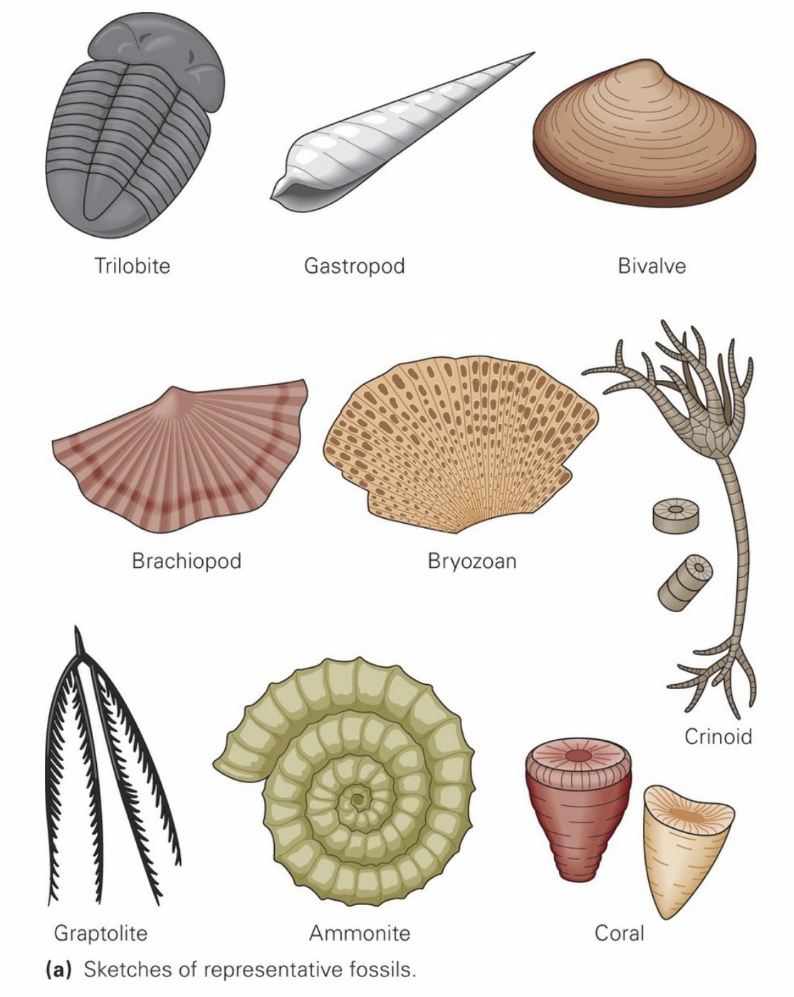
Common Fossils
Petrified Wood: Forms when volcanic ash buries a forest. Groundwater passing through the ash dissolves silica and carries it into the wood, where the silica replaces cell interiors. Eventually, the wood completely transforms into hard chert.
Trilobites: These arthropods have a segmented shell that is divided lengthwise into three parts.
Gastropods: Snails; most fossil specimens have a spiral shell that does not contain internal chambers.
Bivalves: Clams and oysters; these invertebrates have a shell that can be divided into two similar halves. The plane of symmetry lies parallel to the plane of the shell.
Brachiopods (Lamp Shells): The top and bottom parts of lamp shells have different shapes, and the plane of symmetry lies perpendicular to the plane of the shell. Fossils typically have ridges radiating out from the hinge.
Bryozoans: Colonial invertebrates; their fossils resemble a screen-like grid. Each box in the grid represents the shell of a single animal.
Crinoids: Sea lilies; these organisms look like flowers but are actually animals. They have a stalk consisting of numerous circular plates stacked one on top of the other.
Graptolites: These fossils look like tiny saw blades. They are remnants of colonial animals that floated in the sea.
Cephalopods: These squid-like organisms include ammonites, with a spiral shell, and nautiloids, with a straight shell. Their shells contain internal chambers and have ridged surfaces.
Corals: These invertebrates include colonial organisms that form distinctive mounds or columns in tropical reefs. Paleozoic examples include solitary individuals with a cone-like shell.
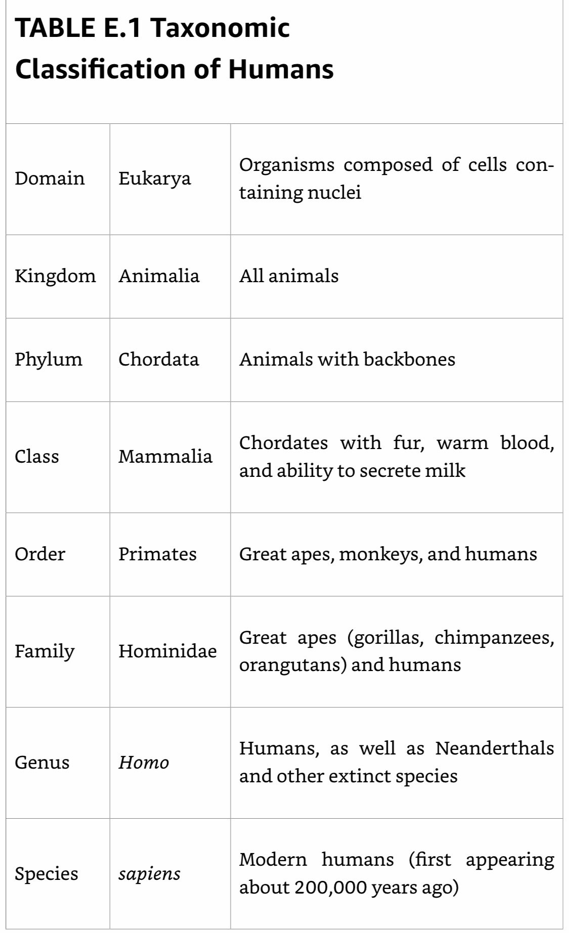
Taxonomy
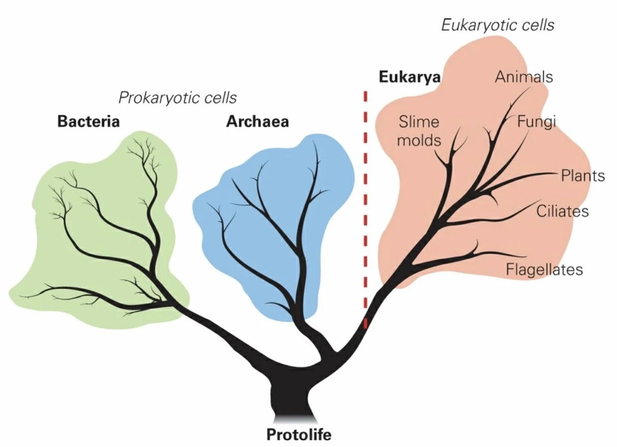
The principles of taxonomy, the study of how to classify organisms in a systematic way, were first proposed in the 18th century by Carolus Linnaeus, a Swedish biologist. Linnaeus based his classification scheme, which divides organisms into a hierarchy of divisions, or taxa, on observable similarities in form and function.
Modern taxonomists divide all life into three domains: Archaea, Bacteria, and Eukarya. (Note that we capitalize these terms only when talking about domain names.) The domains differ from one another based on fundamental characteristics of their DNA.
Archaea: include a vast array of tiny single-celled microorganisms (microbes) that occur not only in the mild environments of oceans, soils, and wetlands, but also in the harsh environments of hot springs, black smokers, salt lakes, very acidic streams, and deep subsurface water.
Extremophiles: Microbes that can survive in harsh environments- they do not need light, but rather live off the energy stored in the chemical bonds of minerals.
Bacteria: Tiny single-celled microbes that inhabit almost all livable environments on the Earth.
Eukarya: Organisms whose cells contain a nucleus. Divided into kingdoms, phyla, class, order, family, genus, species.
Protista: Various unicellular and simple multicellular organisms, including algae.
Fungi: Mushrooms and yeast.
Plantae: Trees, grasses, mosses, and ferns.
Animalia: Sponges, corals, dinosaurs, birds, humans.
Evolution
Phylogeny: Evolutionary relationships.
___________________________________________________________________
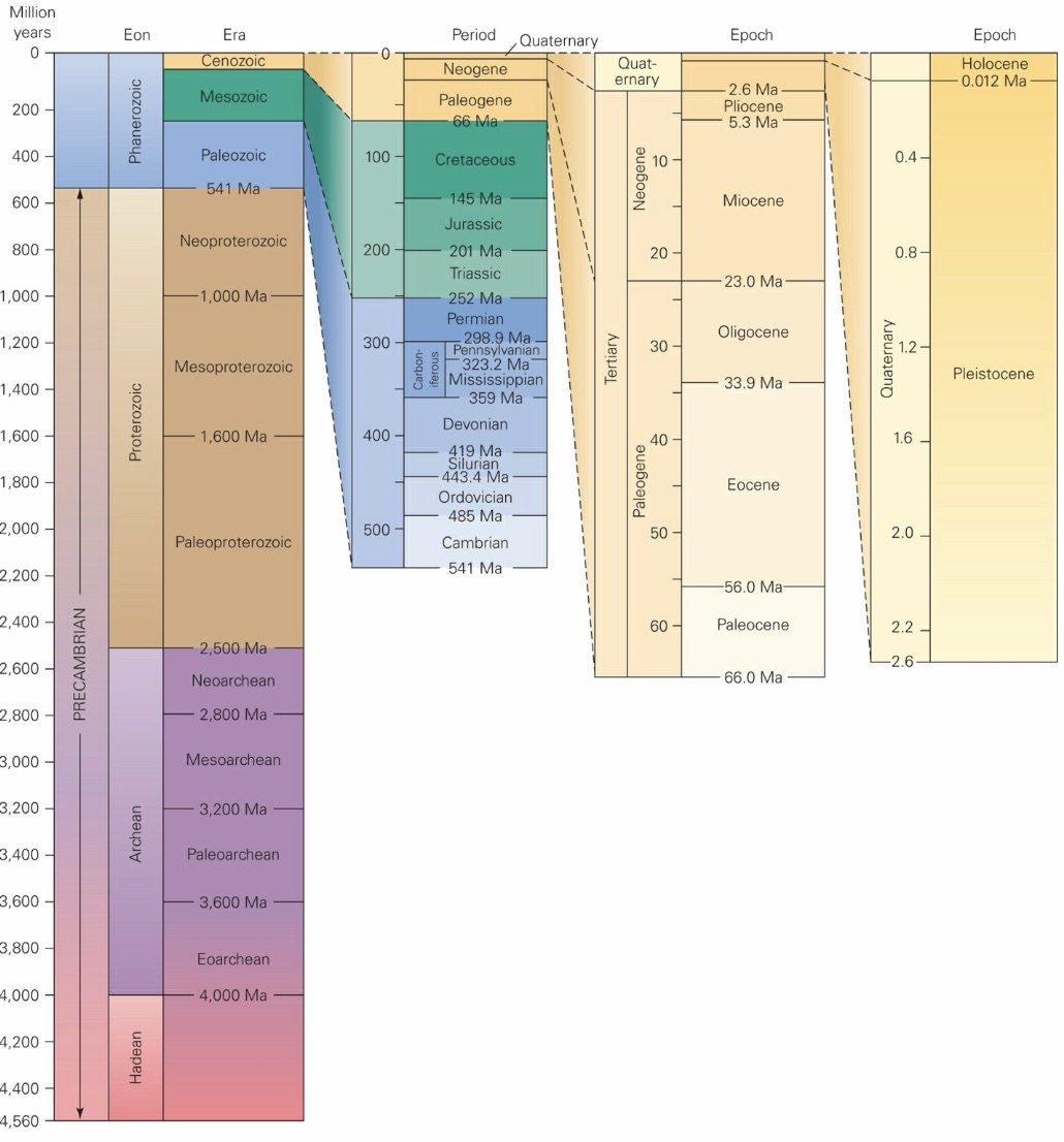
Ch 10: Deep Time
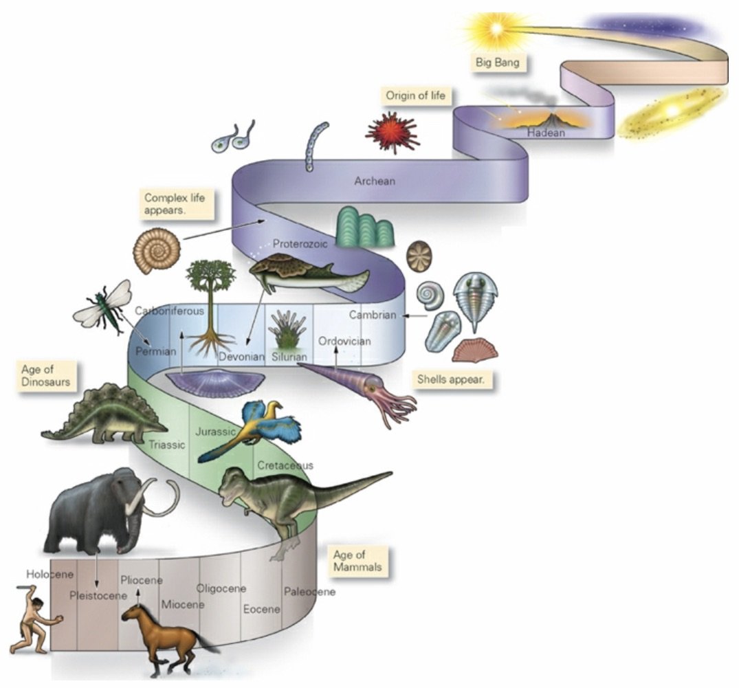
Principle of Uniformitarianism (Hutton): Physical processes we observe operating today also operated in the past, at roughly comparable rates. Put concisely, “the present is the key to the past.”
Stratigraphy
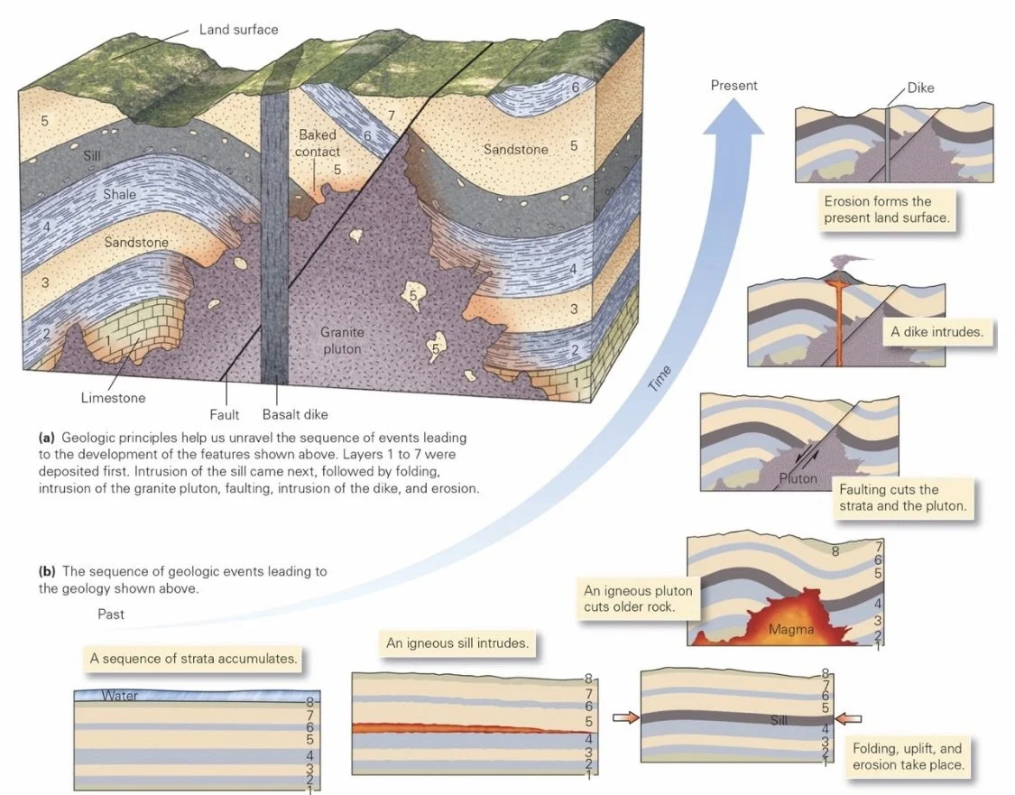
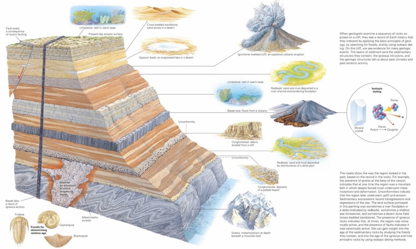
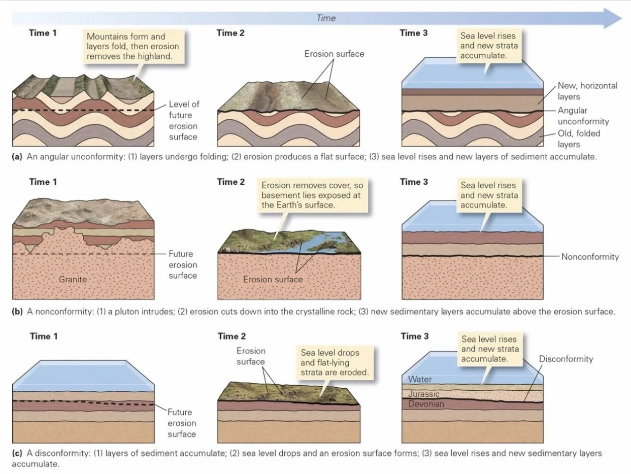
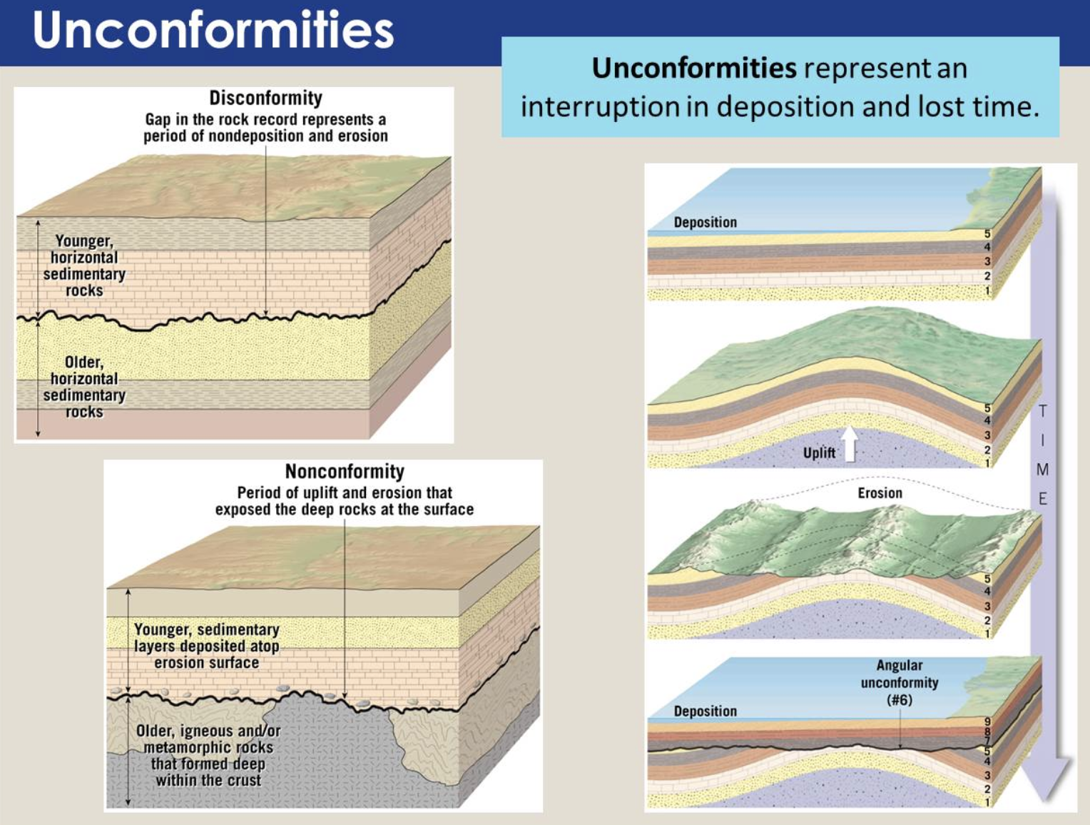
Angular Unconformity: Rocks below an angular unconformity were tilted or folded before the unconformity developed. Unconformities are depicted by a wavy line.
Nonconformity: At a nonconformity, sedimentary rocks overlie generally much older intrusive igneous rocks or metamorphic rocks
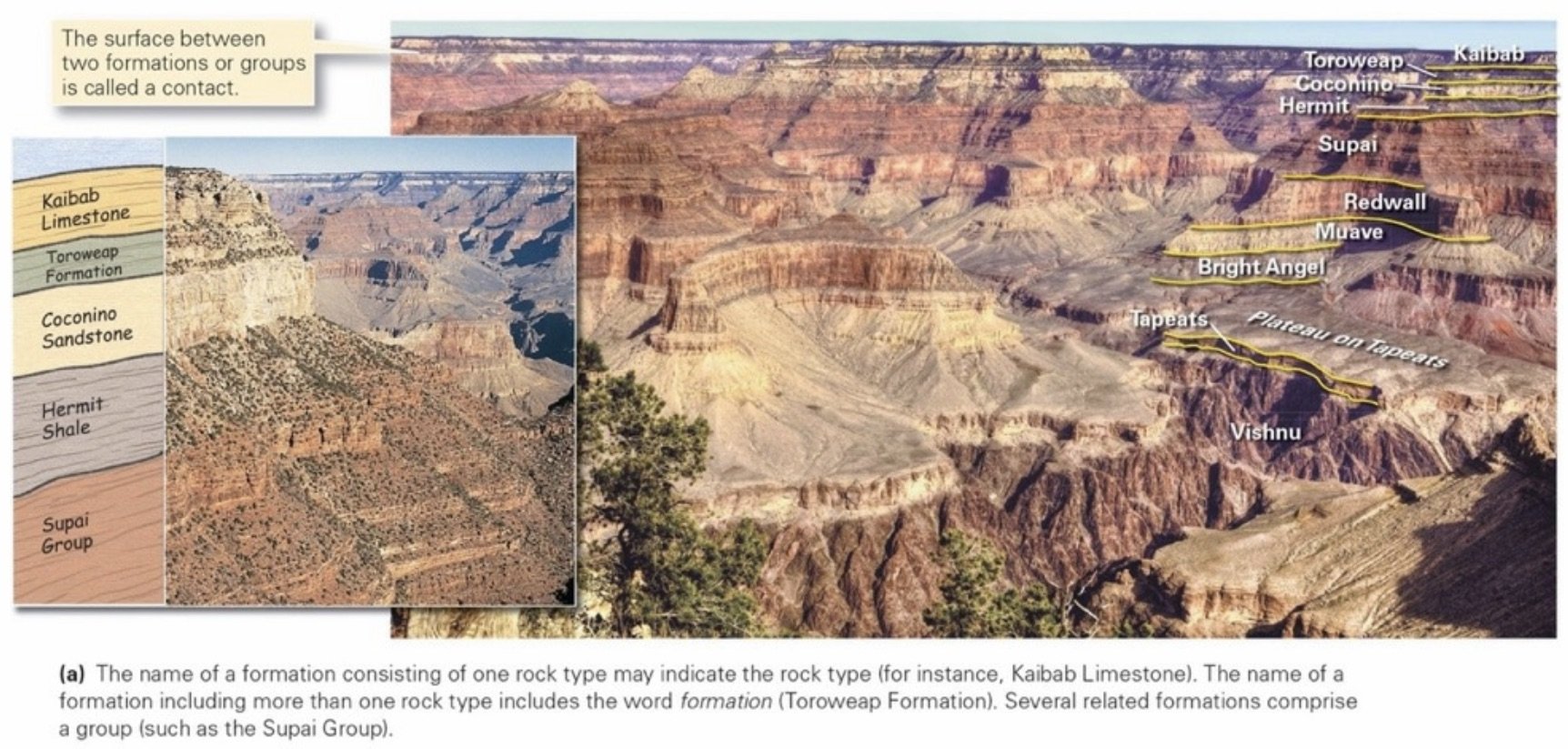
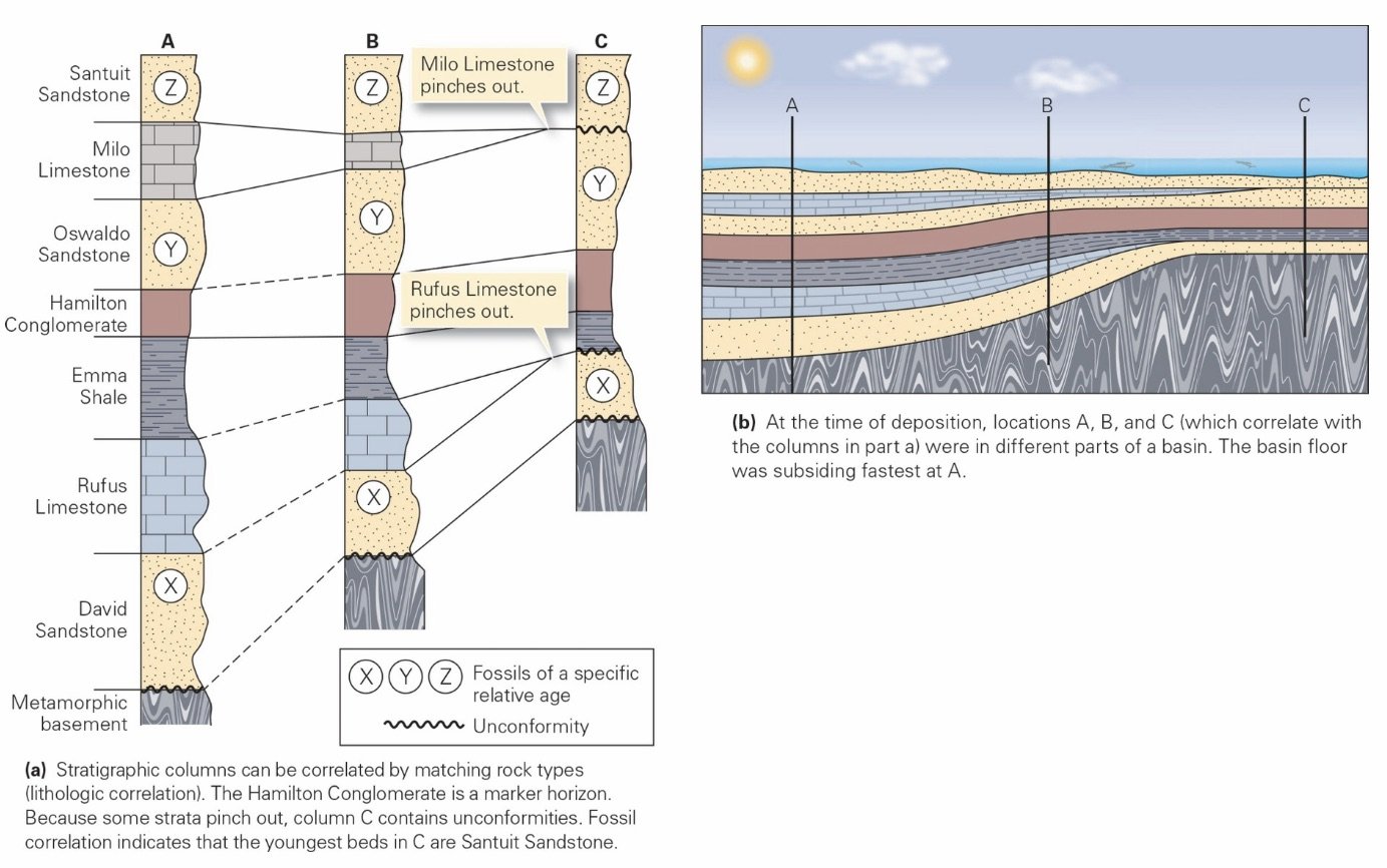
Stratigraphic Formation: An interval of strata composed of a specific rock type or group of rock types that together can be traced over a fairly broad region.
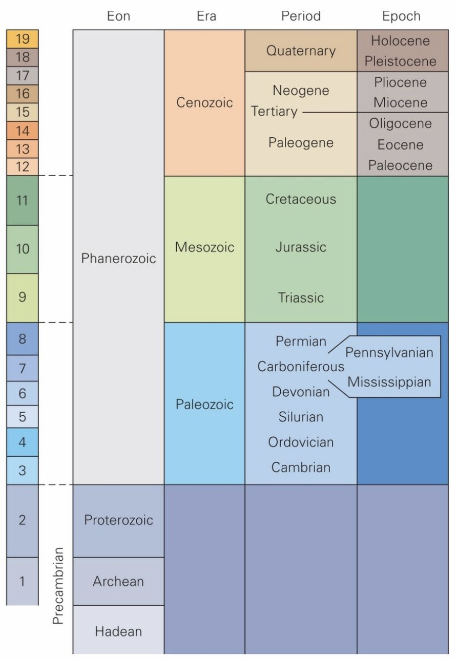
Stratigraphic Column: A chart that depicts the order of the units (with the oldest at the bottom and the youngest at the top), the relative thicknesses of formations, and in some examples, the rock types within each unit.
Rock Age
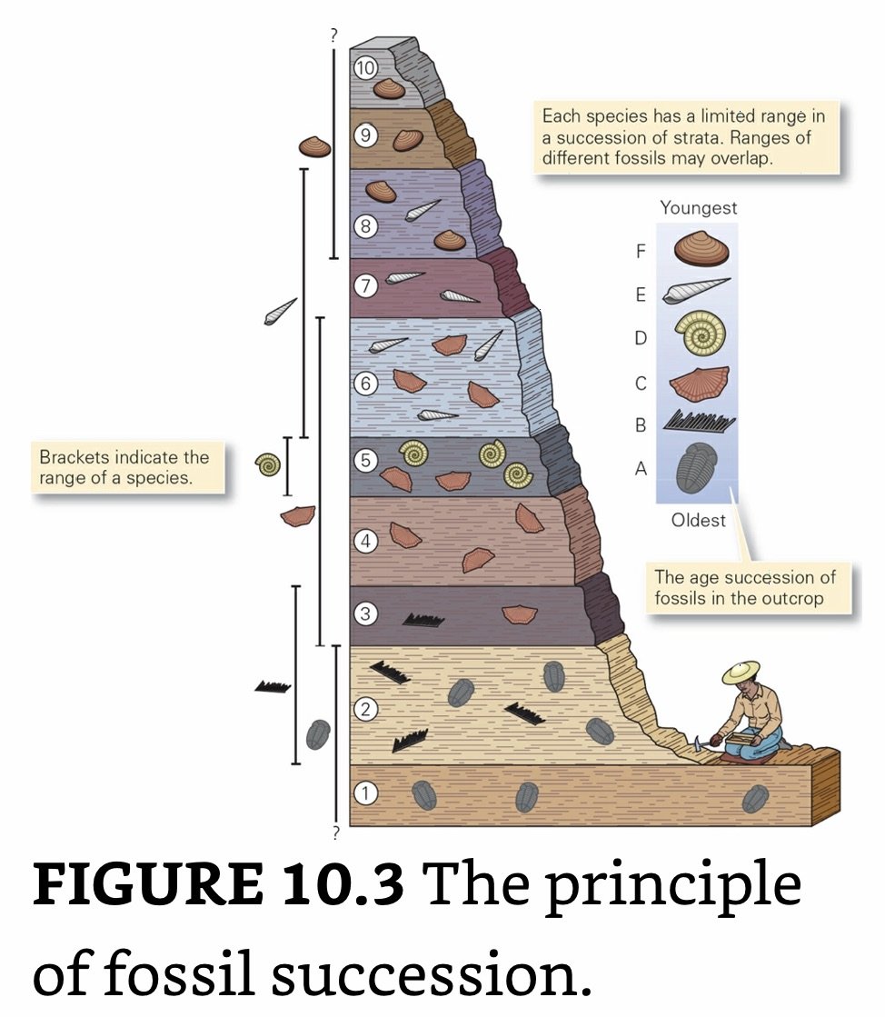
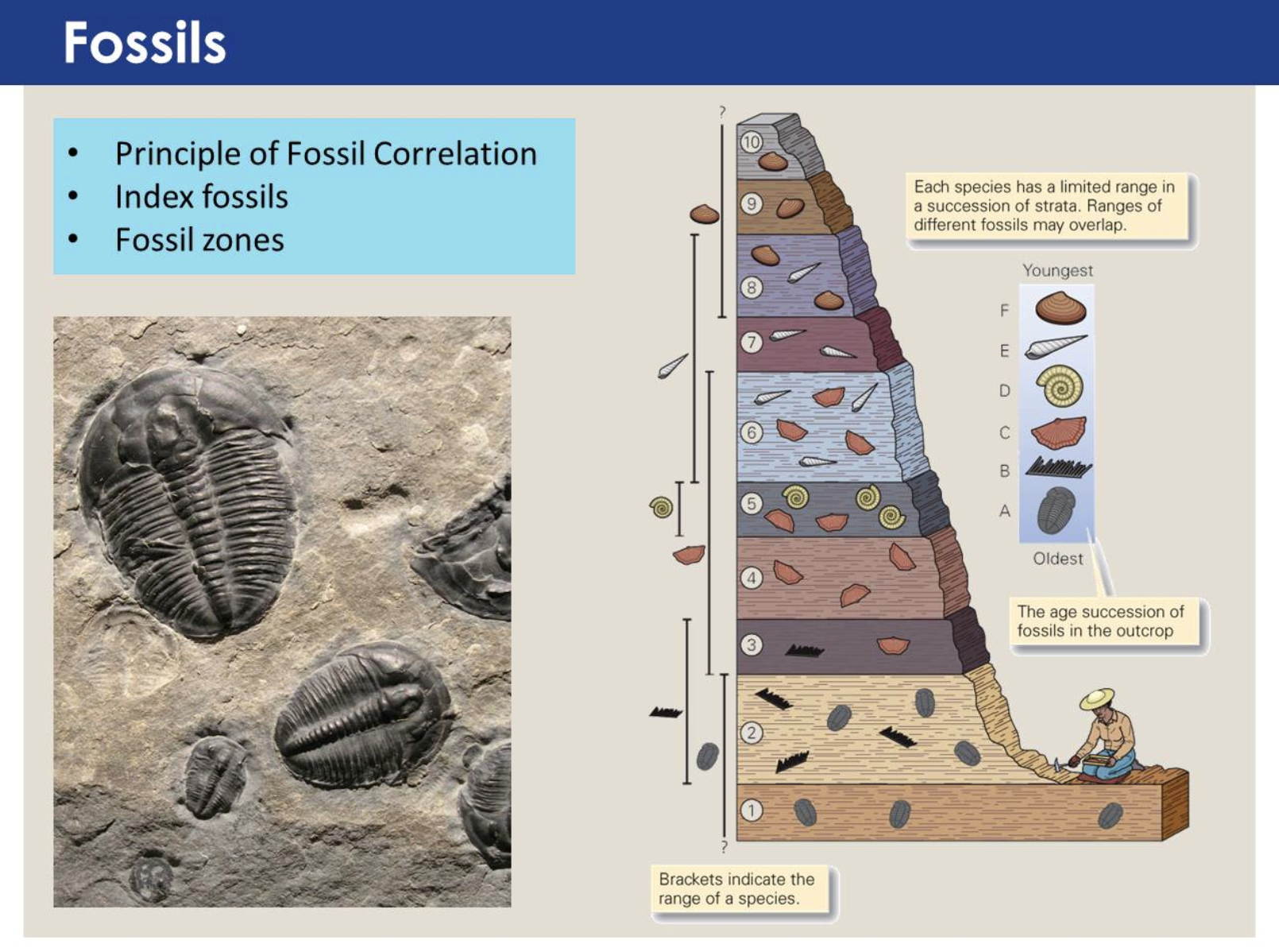
Stratigraphic Correlation: Using relative deposition of rock layers to determine relative age.
Lithologic Correlation: Using sequences of strata from different locations to understand relative age.
Fossil Correlation: Using fossils to determine the relative age of rock strata.
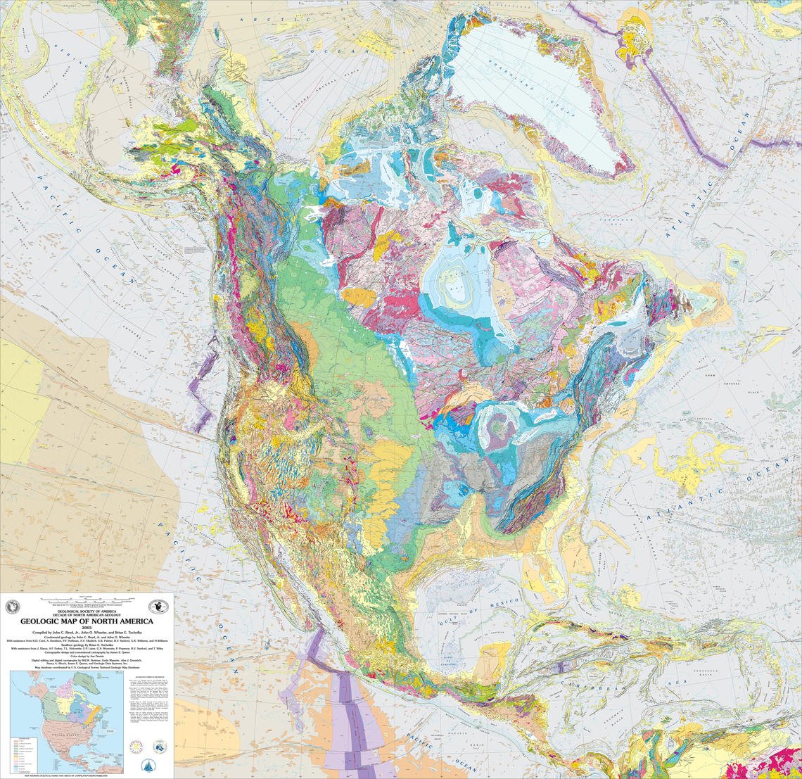
Geologic Map: Portrays the spatial distribution of rock units (stratigraphic formations, metamorphic rocks, and extrusive or intrusive igneous rocks), the contacts among them, and the structures that affect them, at the Earth’s surface.
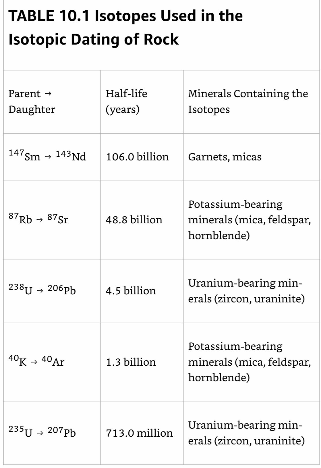
Isotopic/Radiometric Dating
Radioactive (Nuclear) Decay: A process that releases energy stored in nuclear bonds in the nucleus. Some types of radioactive decay result in the expulsion of fragments (alpha and beta particles) from the nucleus of an atom.
Half-Life: We can calculate the age of a mineral by measuring the ratio of parent to daughter atoms.
1) Collecting the Rocks: We need to find unweathered rocks for dating, since the chemical reactions that happen during weathering may lead to the loss of daughter atoms, and in some cases, to the loss of parent atoms.
2) Separating the Minerals: The rocks are crushed, and the appropriate minerals are separated from the debris.
3) Extracting Parent and Daughter Atoms: Done using several techniques, including dissolving the minerals in acid or evaporating portions of them with a laser.
4) Analyzing the Parent-Daughter Ratio: Once we have a sample of appropriate atoms, we pass them through a mass spectrometer, an instrument that uses a strong magnet to separate atoms from one another according to their respective masses. The instrument can count the number of atoms of specific isotopes separately.
5) Calculate the Age: At the end of the laboratory process, we can define the ratio of parent to daughter atoms in a mineral and from this ratio calculate the age of the mineral.
If we date minerals in a sedimentary rock, we determine only when these minerals first crystallized as part of an igneous or metamorphic rock, not the time when the minerals were deposited as sediment, or the time when the sediment lithified to form a sedimentary rock. For example, if we date the feldspar grains contained within a granite pebble in a conglomerate, we’re dating the time the granite cooled below feldspar’s closure temperature, not the time the pebble was deposited by a stream.
Isotopic dating determines when an igneous rock solidified and when a metamorphic rock cooled. To date sedimentary strata, we must examine cross-cutting relations with dated igneous or metamorphic rock.
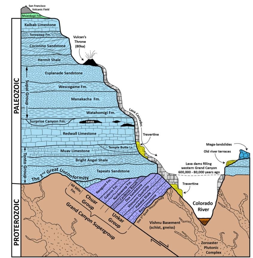
Grand Staircase
Using correlation techniques, geologists have determined that the oldest sedimentary rocks of the region crop out near the base of the Grand Canyon, whereas the youngest form the cliffs of Cedar Breaks and Bryce Canyon.
When the Precambrian metamorphic and igneous rocks exposed in the inner gorge of the Grand Canyon first formed, the region was a high mountain range, perhaps as dramatic as the Himalayas today. When the fossiliferous beds of the Kaibab Limestone at the rim of the canyon first developed, the region was a Bahamas-like carbonate reef and platform, bathed in a warm, shallow sea. And when the rocks making up the towering red cliffs of sandstone in Zion Canyon were deposited, the region was a Sahara-like desert, blanketed with huge sand dunes.
___________________________________________________________________
Ch 11: A Biography of the Earth
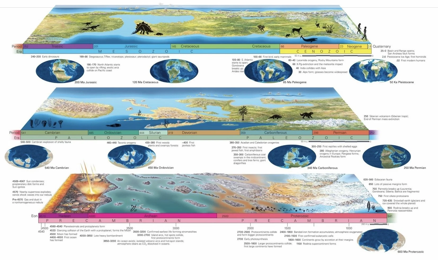
The Earth formed about 4.56 billion years ago. At times during the Hadean Eon, the planet was so hot that its surface was a magma ocean. The Archean Eon began at 4.0 Ga, about when the oldest rock that remains formed. Continental crust, assembled out of volcanic arcs and hot-spot volcanoes that were too buoyant to subduct, grew during the Archean, and the first life forms—bacteria and archaea—appeared. During the Proterozoic Eon, which began at 2.5 Ga, Archean cratons collided and sutured together along orogenic belts, forming large Proterozoic cratons. Photosynthesis added oxygen to the atmosphere. By the end of the Proterozoic, complex shell-less marine invertebrates populated the planet. Most continental crust assembled to form a supercontinent called Rodinia at about 1 Ga.
At the beginning of the Paleozoic Era, rifting yielded several separate continents. During the Paleozoic, sea level rose and fell, yielding sequences of strata in continental interiors. Collisional orogeny’s produced another supercontinent, Pangaea, at the end of the era. Early Paleozoic evolution produced many invertebrates with shells, as well as jawless fish. Land plants and insects appeared in the middle Paleozoic. And, by the end of the era, there were land reptiles and gymnosperm trees. In the Mesozoic Era, Pangaea broke apart and the Atlantic Ocean formed. Convergent-boundary tectonics dominated along the western margin of North America. Dinosaurs appeared in Late Triassic time and became prominent land animals through the Mesozoic Era. During the Cretaceous Period, sea level was relatively high, and the continents flooded. Angiosperms appeared at this time, along with modern fish. A huge mass-extinction event.
In the Cenozoic Era, continental fragments of Pangaea collided again. The collision of Africa and India with Asia and Europe formed the Alpine-Himalayan orogen. Convergent tectonics has persisted along the margin of South America, producing the Andes, but ceased in North America when the San Andreas fault formed. Rifting in the western United States during the Cenozoic Era produced the Basin and Range Province. During the Cenozoic, various kinds of mammals filled niches left vacant by the disappearance of dinosaurs. The human genus, Homo, appeared and evolved throughout the radically shifting climate and ice ages of the Pleistocene Epoch.
Origin & Evolution of Life
Recent researchers suggest that submarine hot-water vents, ‘black smokers’, served as the hosts of the first organisms. These vents emit clouds of ion-charged solutions from which sulfide minerals precipitate and build chimneys.
Archean (4.0–2.5 Ga): The first continental crust formed. As the oceans filled, the atmosphere lost its H2O and CO2, but throughout the Archean, it remained devoid of O2.
Later in the Archean, organisms similar to cyanobacteria evolved the ability to carry out photosynthesis and moved into shallower, well-lit water. Although these organisms produced O, very little accumulated in the atmosphere.
Phanerozoic Eon: Consists of the Paleozoic (‘ancient life’- Greek), the Mesozoic (middle life), and the Cenozoic (recent life).
At the beginning of the Paleozoic Era, Pannotia broke up, yielding smaller continents, including Laurentia (North America and Greenland), Gondwana (South America, Africa, Antarctica, India, and Australia), Baltica (Europe), and Siberia.
Cambrian Explosion: The appearance of invertebrates with shells defines the Precambrian-Cambrian boundary. At this time, a sudden diversification in life took place, with many new types of organisms appearing over a relatively short interval.
The first fish appeared in Ordovician seas, land plants started to spread over the continents during the Silurian (prior to this time the land surface was unvegetated), and amphibians appeared during the Devonian. Although the first reptiles appeared during the Pennsylvanian Period, the first dinosaurs did not stomp across the land until the Triassic. Dinosaurs continued to inhabit the Earth until their sudden extinction at the end of the Cretaceous Period. For this reason, geologists refer to the Mesozoic Era as the Age of Dinosaurs. Small mammals appeared during the Triassic Period, but the diversification (branching into many different species) of mammals to fill a wide range of environments did not happen until the beginning of the Cenozoic Era, so geologists call the Cenozoic the Age of Mammals. Birds also appeared during the Mesozoic (at the beginning of the Cretaceous Period) but underwent great diversification in the Cenozoic Era.
Devonian: At the end of the Devonian, the first tetrapod’s, animals with legs, crawled out onto land and inhaled air with lungs
Amphibians and, later, reptiles populated the land. The appearance of reptiles marked the evolution of a radically new component in animal reproduction—eggs with a protective shell. Such eggs permitted reptiles to reproduce without returning to the water.
Triassic: The earliest ancestors of mammals appeared at the end of the Triassic, in the form of small, rat-like creatures.
Pterosaurs, with wingspans of up to 11 m, soared overhead,
Later Cenozoic: Our own direct ancestors first appeared. Specifically, ape-like primates diversified in the Miocene Epoch (about 20 Ma), and the first human-like primate evolved at about 4 Ma, followed by the first members of the human genus, Homo, at about 2.4 Ma. Fossil evidence, primarily from Africa, indicates that Homo erectus, capable of making stone axes, appeared about 1.6 Ma. According to the fossil record, modern people appeared about 200 Ka, initially sharing the planet with two other species of the genus Homo, the Neanderthals and the Denisovans. When the Neanderthals and Denisovans died out more than 25 Ka, Homo sapiens remained as the only human species on Earth.
Orogeny
Alleghenian Orogeny: The final stage in the development of the Appalachians; occurred when eastern North America rammed into northwestern Africa, and what is now the Gulf Coast region of North America squashed against the northern margin of South America.
___________________________________________________________________
Ch 12: Energy and Mineral Resources
Energy: The capacity to do work.
Solar Energy & Wind: Energy from the Sun heats the air, which becomes buoyant and rises. As this happens, gravity causes cooler air to sink, resulting in wind, which turns windmills.
Hydro-energy: Moving water can drive waterwheels that power machines or generators that produce electricity.
Photosynthesis: Algae and green plants absorb solar energy and, through photosynthesis, produce sugar. From this sugar, they manufacture complex organic chemicals.
Biomass: The burning of organic chemicals react with O and break apart to produce CO2, H2O, and C (soot). These reactions release the energy stored in chemical bonds. More recently, chemists have developed processes to convert biomass into flammable liquids, including ethanol.
Fossil Fuels: Hydrocarbon based fuels, such as oil, natural gas, and coal, store solar energy that reached the Earth long ago. This solar energy was converted into organic matter; which, when buried, can be preserved in rocks over geologic time.
Earth’s Internal Energy: The Earth remains very hot inside—some of this internal energy dates from the birth of the planet, while some comes from later radioactive decay. Internal energy heats underground water, which can warm buildings at the surface or, when transformed to steam, can drive electrical generators.
Hydrocarbons
The viscosity (ability to flow) and the volatility (ability to evaporate) of a hydrocarbon product depend on the size of its molecules. Products made of short chains of molecules tend to be less viscous (they flow more easily) and more volatile (they evaporate more easily) than products composed of long chains, because the long chains tend to tangle up with each other.
Oil and gas have a high energy density, meaning that they provide a relatively large amount of energy per unit volume.
The chemicals that make up oil and gas came mostly from plankton.
How Organic Matter becomes Oil: At relatively low temperatures, buried organic matter decays, releasing biogenic natural gas. As organic shale becomes buried more deeply, they warm, for temperature increases with depth in the Earth. Chemical reactions take place in source rocks as they exceed 50°C, slowly transforming the organic material in the shale into a mass of waxy molecules called kerogen. Shale with more than 25% to 75% kerogen is called oil shale. If oil shale becomes buried even more deeply, warming to temperatures above 90°C, kerogen molecules break into smaller oil and gas molecules, a process known as hydrocarbon generation. At temperatures between 150°C and 225°C, oil molecules break down into thermogenic (produced by heat) natural gas, and at temperatures over 225°C, organic matter loses all its hydrogen and transforms into graphite (pure carbon). Thus, oil forms only at temperatures between 90°C and 150°C, a range called the oil window. Thermogenic natural gas can form in the larger gas window (90°C to 225°C). A typical value for the geothermal gradient, the rate at which temperature increases with depth, is 25°C/km. At this gradient, the oil window occurs at depths of 3.5 to 6.5 km, and the gas window extends down to 9 km.
Porosity: The proportion of a rock that consists of open spaces, or pores.
Shale typically has porosity of less than 10%. In contrast, a poorly cemented sandstone has porosity of up to 35%, so about a third of a block of sandstone would consist of open space. Note that oil and gas in a reservoir rock reside in the pores, not in underground pools.
Permeability: The degree to which pore spaces and cracks connect to one another, either because adjacent pores happen to open into each other or because fracturing broke apart otherwise solid rock. Permeability allows fluids (water, oil, or gas) to flow through the rock.
When we say that a good reservoir rock has high porosity and permeability, we mean that the rock can contain a lot of oil or gas, and that oil or gas can be pumped out of the rock relatively easily.
Oil Seep: A migration pathway that connects the reservoir rock to the Earth’s surface.
An oil or gas trap has two components. First, a seal rock, a relatively impermeable rock such as shale, salt, or unfractured limestone, must lie above the reservoir rock and stop the hydrocarbons from rising further. Second, the seal and reservoir rock bodies must be arranged in a geometry that holds the hydrocarbons in a restricted area to make pumping economical.
Oil Extraction
Rock Oil (later ‘petroleum’, petra: rock + oleum: oil, Latin).
Mud: Drillers pump drilling mud, a slurry of water mixed with clay and other materials, down the center of the pipe. The mud flows down, past the propeller that rotates the drill bit, and then squirts out of holes at the end of the bit. The extruded mud cools the bit, which otherwise would heat up due to friction as it grinds against rock. Then, the mud flows up the hole on the outside of the drill pipe, carrying cuttings (fragments of rock that had been broken up by the drill bit) along with it. Mud also serves another very important purpose—its weight counters the pressure of the oil and gas in underground reservoir rocks, and thus prevents the hydrocarbons from entering the hole. Were it not for the mud, the natural pressure in the reservoir rock would drive oil and gas into the hole, and if the pressure were great enough, the hydrocarbons would rush up the hole and spurt out of the ground as a gusher or blowout. Blowouts are disastrous, because they spill oil onto the land or into the sea and, in some cases, ignite into a deadly inferno.
After completion, workers remove the derrick and either cap the hole or install a pump. When pumping begins, the completed well becomes a producing well.
Simple pumping brings only about 20% to 30% of the oil from a reservoir rock out of the ground.
Once extracted, crude oil, the unrefined oil that comes straight out of the ground, is pumped into storage tanks. Later, pipelines or tankers transport crude oil to a refinery, where workers separate crude oil into different-sized molecules by heating it in a vertical pipe called a distillation column. Lighter molecules rise to the top of the column, while heavier molecules stay at the bottom. The heat may also “crack” larger molecules to make smaller ones. Chemical factories buy the largest molecules left at the bottom and transform them into plastics.
Where the costs are too high to process natural gas that comes up with oil, rig operators vent the gas from a pipe and “flare it” (burn it) where it enters the air.
Middle East Oil: Reconstructions of past positions of continents indicate that much of this region was situated in tropical areas, between latitude 20° south and 20° north, during the time between the Jurassic (135 Ma) and the Late Cretaceous (66 Ma). Biological productivity was high, so sediments deposited at that time were rich in organic matter. Thick successions of porous sandstone buried the source rocks of the Middle East, and crustal compression due to the collision between Africa and Asia folded the strata to produce excellent traps.
Shale Oil/Gas: Huge quantities of oil and natural gas remain in source beds of organic shale, even after the strata have been heated to the oil window or gas window.
Hydrofracturing: Using traditional drilling and producing methods, it was not cost-effective to extract source-bed hydrocarbons, for two reasons. First, since the hydrocarbons had not migrated into a trap, a vertical well could not access a significant supply. Second, the source beds are so impermeable that the hydrocarbons would not flow to a pumping well. The development of directional drilling and hydrofracturing radically changed this picture. As a result of directional drilling, a single well can follow a source bed horizontally for many kilometers, and several wells can be drilled from the same platform in different directions into the source bed, so a large volume of reserves can be accessed. Because of hydrofracturing, a rock’s permeability can be increased sufficiently to permit the hydrocarbons to flow into the drillhole…Once hydrofracturing concludes, drillers pump out the fracking fluid. Hydrocarbons then flow along the fractures into the drillhole and up to the surface, where drillers capture it.
Fracking Fluid: Typically consists of ~90% water, 9.5% quartz sand, and 0.5% other chemicals. The sand props the holes open once the fluid has been removed—without the sand, the cracks opened by hydrofracturing would close up tightly under the pressure applied by surrounding rock, and thus they could not serve as permeability pathways. The 0.5% portion of fracking fluid that is not water or sand contains many chemicals, including: oils that make the fluid slippery so it can inject farther into the rock; acid, which dissolves cement between grains and increases porosity; detergent, which lowers the surface tension of water so it doesn’t stick to grains; guar gum, to make the fluid more viscous so that it can carry more sand; antifreeze, to prevent scale buildup or fluid freezing; and biocides, which prevent the growth of bacteria that could clog pores.
The most common concern is that fracking fluid can contaminate drinking water underground.
Carbon Capture and Sequestration (CCS): Involves three steps; 1) CO2 is removed from the effluents sent up smokestacks at power plants or factories; 2) CO2 gas is transformed into liquid; and 3) CO2 is pumped down wells into reservoir rocks deep underground.
Blowout: Occurs when the pressure within a HC reserve penetrated by a well exceeds the pressure that drillers had planned for, causing the HCs (oil or gas) to rush up the well in an uncontrolled manner and burst out of the well at the surface in an oil gusher or gas plume.
Hubbert’s Peak: The peak of production for a given reserve.
Geologists estimate that we’ve already used a substantial proportion of our conventional reserves, but that about 1,250 billion barrels of proven conventional oil reserves remain. Proven reserves have been documented and are still in the ground. Optimistically, an additional 2,000 billion barrels of conventional oil supplies may exist. Thus, the world conceivably holds as much as 3,250 billion barrels of conventional oil. Presently, humans consume oil at a rate of about 35B barrels per year. At this rate, conventional oil supplies may last no more than about 100 years.
Hydrocarbon Types
Bitumen: Tar-like heavy oil exist.
Tar/Oil Sand: Sandstone containing high concentrations of bitumen.
Oil Shale: Rock strata containing shale oil that have been through the oil window.
Shale Oil: Oil extracted from source beds.
Energy companies produce liquid oil from oil shale. The process involves heating the oil shale in a kiln to a temperature of 500°C, which causes the shale to decompose and the kerogen to transform into liquid hydrocarbons and gas. As is the case with tar sand, producing oil from oil shale is possible but very expensive.
Coal: Bonded C atoms that form large, complicated molecules called coal macerals. Coal forms from vascular plant material (wood, stems, leaves), not plankton; occurs in beds, called coal seams, that may be centimeters to meters thick and may be traceable over broad regions.
Peat: When vegetation of an ancient swamp dies, falls down, and becomes buried in an O-poor environment, such as stagnant water. In this way, the organic matter can become incorporated in a sedimentary sequence before it gets eaten or undergoes complete decay. Compaction and partial decay of the vegetation transforms it into peat, which consists of up to 50% to 60% C and can itself be dried and then burned as fuel.
Peat- Coal: To transform peat into coal, the peat must be buried by 4 to 10 km of overlying sediment. Heat accelerates chemical reactions that gradually destroy plant fiber and release molecules of H, NH3, CH4, and sulfur dioxide as gases. These gases seep out of the reacting peat layer, leaving behind a residue concentrated with C. Once the proportion of C in the residue > 60%, the deposit formally becomes coal.
Peat- Lignite: Shallower burial transforms peat into a soft, dark-brown coal called lignite.
Lignite- Bituminous Coal: At greater depths and higher temperatures (about 100°C–200°C), lignite, in turn, becomes dull, black bituminous coal.
Bituminous Coal- Anthracite: At still greater depths and even higher temperatures (about 200°C–300°C), bituminous coal transforms into shiny, black anthracite.
Coal Mining
Strip Mining: Used to mine coal that lies within ~100m of the ground surface. In strip mines, miners use a giant shovel called a dragline to scrape off soil and layers of sedimentary rock above the coal seam. Draglines are so big that the shovel could swallow a two-car garage without a trace. Once the dragline has dug an open pit or trench to expose the seam, miners use smaller power shovels to dig out the coal and dump it into trucks or onto a conveyor belt.
Underground Mining: Used to mine deep coal.
Nuclear Energy
Nuclear Fission: Breaking the nuclear bonds that hold protons and neutrons together in the nucleus, to split a large atom into smaller pieces. During this process, a small amount of mass transforms into a large amount of thermal and electromagnetic energy. Fission occurs when a neutron strikes a radioactive atom, causing it to split and release more neutrons. Uranium-235 splits into Ba-141 and Kr-92, plus three neutrons. The neutrons released during fission of one atom will then strike three other atoms, thereby triggering more fission in a self-perpetuating process called a chain reaction that produces lots of heat. Pipes carry water close to the heat-generating fuel rods, and the heat transforms the water into high-pressure steam. The pipes then carry this steam to a turbine, where it rotates fan blades. The rotation, in turn, drives a dynamo that generates electricity. Eventually, the steam goes into cooling towers, where it condenses back into water that can be reused in the plant or returned to the environment.
The rate of nuclear fission must be regulated by the insertion of control rods, which absorb neutrons and thus decrease the number of collisions between neutrons and radioactive atoms. If not properly controlled, the fuel could become so hot that it would melt. Such a meltdown might cause a steam explosion that could breach the containment building and scatter radioactive debris into the air. In some cases, the water gets so hot that it splits into H and O gases that can recombine explosively.
Nuclear Fuel: Consistsof pellets of concentrated U-oxide or a comparable radioactive material, packed into metal tubes called fuel rods.
235U: The radioactive isotope of uranium that serves as the most common fuel for nuclear power plants, accounts for only about 0.7% of naturally occurring U—most natural U consists of 238U.
Nuclear engineers have designed new generations of power plants that produce far less waste and cannot have a meltdown. But many people view nuclear plants with concern because of issues pertaining to radiation, accidents, terrorism, and waste storage, and these concerns have slowed down the industry.
Biofuels: Liquid HC’s produced from crops. The most commonly used biofuel is ethanol, a type of alcohol.
Producers grind corn into a fine powder, mix it with water, and cook it to produce a mash of starch. They then add an enzyme to the mash, which converts the starch to sugar. The sugar, when mixed with yeast, ferments to produce ethanol, water, and CO2. Finally, the ethanol is distilled to concentrate the ethanol. Ethanol can also be produced directly from sugar extracted from sugarcane, without fermentation, so sugarcane ethanol is less expensive than corn alcohol.
Renewable/Sustainable Energy Sources
Hydroelectric Power Plants: Water flows from a higher elevation to a lower elevation. The flowing water turns turbine blades placed in a pipe, and the turbine drives an electrical generator.
Solar Collector: Made up of mirrors that focus light striking a broad area into a smaller area. On a small scale, such devices can be used for cooking; on a large scale, they can produce steam to drive turbines.
Photovoltaic Cells (Solar Cells): Convert light energy directly into electricity. Most photovoltaic cells consist of two wafers of silicon pressed together. One wafer also contains atoms of arsenic, and the other wafer includes atoms of boron. When light strikes the cell, arsenic atoms release electrons that flow over to the boron atoms. If a wire loop connects the back side of one wafer to the back side of the other, this phenomenon produces an electrical current.
Metals & Minerals
Metal: An opaque, shiny, smooth solid that can conduct electricity and is malleable, meaning it can be bent, drawn into wire, or hammered into thin sheets.
Metallic Mineral Resources: Materials containing gold, copper, aluminum, iron, or other metals.
Nonmetallic Mineral Resources: Building stone, gravel, sand, gypsum, phosphate, salt used in construction.
Ore: A rock containing a relatively high concentration of ore minerals or native metals. The weight percent of a useful metal in an ore determines the grade of the ore—the higher the weight percent, the higher the grade.
Most copper ore used today has a grade of 0.4% to 1.0%.
Quarry: Provides stone.
Mine: Supplies ore.
Mortar/Concrete: Both mortar and concrete start out as a slurry, but when allowed to set, they harden into a hard, rock-like substance. The slurry from which mortar and concrete form consists of aggregate (sand and/or gravel) mixed with water and cement. Before mixing, the cement in mortar and concrete is a powder made of lime (CaO), quartz (SiO2), aluminum oxide (Al2O3), and iron oxide (Fe2O3). Typically, lime accounts for 66% of cement and silica for 25%. When cement powder mixes with water, the chemicals in it dissolve. Mortar and concrete set (solidify) when dissolved chemicals recombine to produce a complex assemblage of new mineral crystals. These minerals bind together the grains of aggregate, much as quartz or calcite binds together grains of quartz in a sandstone.
Portland Cement (Johnson, 1844): The majority of cement today; produced by mechanically mixing limestone, sandstone, and shale in just the right proportions, then heating it in a kiln to yield a powder with the correct chemical makeup to mix into cement.
___________________________________________________________________
Interlude F: Landscapes & The Hydrologic Cycle
Landscapes
Uplift: The upward movement of the Earth’s surface
Subsidence: The sinking or downward movement of the Earth’s surface.
Relief: The elevation difference between two points separated by a specified horizontal distance on a map.
Hydrologic Cycle: Solar radiation heats water, making water molecules vibrate faster. Some of the molecules evaporate—they effectively shake free of the liquid, drift upward in a gaseous state, and mix into the atmosphere. About 30% of the total ocean volume evaporates every year. Atmospheric water vapor moves with the wind to higher elevations, where it cools, undergoes condensation, and rains or snows. About 76% of this water precipitates (falls out of the air) directly back into the ocean. The remainder precipitates onto land, where most becomes trapped temporarily in the soil or in plants and animals. It soon returns directly to the atmosphere by evapotranspiration, meaning the sum of evaporation from bodies of water, evaporation from the ground surface, and release of water from plants and animals. Precipitation that does not become trapped in the soil or in living organisms has several potential routes. It becomes surface water (held in lakes, rivers, or swamps), it becomes ice in glaciers, or it sinks deeper into the ground to become groundwater. All of this water eventually ends up in the sea, either by flowing directly or by first returning into the air from which it later precipitates.
Residence Time: The average length of time that water stays in a particular reservoir during the hydrologic cycle.
___________________________________________________________________
Ch 13: Landslides and Mass Movements
Regolith: Soil and loose sediment or debris.
Landslide: Any mass movement of rock or regolith down a non-vertical slope, distinguished based on four features: 1) the type of material involved (rock or regolith); 2) the velocity of movement (slow, intermediate, or fast); 3) the character of the moving mass (coherent or chaotic; wet or dry); and 4) the environment in which the movement takes place (subaerial or submarine).
Creep: The slow, gradual downslope movement of regolith on a slope. Creep happens when regolith alternately expands and contracts in response to freezing and thawing, wetting and drying, or warming and cooling.
Solifluction: A type of creep characteristic of tundra regions; during the summer, the uppermost layer of permafrost melts, and the soggy, weak layer of ground then flows slowly downslope in overlapping sheets.
Slump: A relatively slow-moving mass movement during which moving rock or regolith does not disintegrate but rather stays somewhat coherent.
Cornice: A large drift of snow that builds up on the lee side of a windy mountain summit.
Debris Flow (‘Debris Slide’): The sudden downslope movement of material consisting only of regolith.
Lahar: A thick slurry formed when volcanic ash and debris mix.
Rockslide: A sudden downslope movement of rock.
Snow Avalanche: Rapid downslope movement of a mass of snow; typically, the movement transforms the snow into a turbulent cloud.
Rockfall: A mass of rock that separates from a cliff, typically along a joint, and then free-falls downslope.
Debris Fall: A mass movement event in which fragments of various sizes, including large chunks and fine sediment, free fall down a slope.
Talus: A sloping apron of fallen rock along the base of a cliff.
Turbidity Current: A submarine avalanche of sediment and water that speeds down a submarine slope.
Mudflow (‘Mudslide’): A downslope movement of mud at slow to moderate speed.
Submarine Slump: The underwater downslope movement of a semi-coherent block of sediment along a weak mud detachment.
Angle of Repose: The steepest slope that a pile of unconsolidated sediment can have and remain stable. The angle depends on the shape and size of grains.
___________________________________________________________________
Ch 14: Stream and Floods
River Types
Dendritic: When rivers flow over a fairly uniform substrate, they develop a dendritic network that looks like the pattern of branches connecting to the trunk of a deciduous tree.
Radial: Drainage networks forming on the surface of a cone-shaped mountain flow outward from the mountain peak, like spokes on a wheel. Such a pattern defines a radial network.
Rectangular: In places where a rectangular grid of fractures (vertical joints) breaks up the ground, channels follow pre-existing fractures and streams join each other at right angles, creating a rectangular network.
Trellis: Where a drainage network develops across a landscape of parallel valleys and ridges, major tributaries flow down a valley and join a trunk stream that cuts across the ridges. The resulting map pattern resembles a garden trellis, so such an arrangement of streams is called a trellis network.
Parallel: On a steep, uniform slope, several streams with parallel courses develop simultaneously. The group comprises a parallel network.
Stream Channels: Form by downcutting and lengthen by headward erosion. They carry water from sheetwash, lakes, springs, and melting snow or ice.
Drainage Networks: Carry water from a watershed to the sea and have a variety of geometries.
Permanent Streams: Streams that flow all year; exist where the water table lies above the bed of the channel or when large amounts of water enter the channel from upstream.
Ephemeral Streams: Streams that flow intermittently; exist where the water table lies below the channel bed.
Competence: The maximum particle size carried by a stream; dependent on both the speed and viscosity of the water. A stream with high competence can carry large particles, whereas one with low competence can carry only small particles.
Braided Stream: In some localities, streams carry abundant coarse sediment during floods, but they cannot carry this sediment during normal flow. As a result, during normal flow, the sediment settles out and chokes the channel. Because the gravelly sediment can’t stick together, the stream cannot cut a single deep channel with steep banks—the channel walls simply collapse. As a consequence, the stream divides into numerous strands weaving back and forth between elongate bars of gravel and sand.
Precipitation
Sheetwash: A film of water less than a few mm thick that covers the ground surface during heavy rains.
Discharge: The volume of water passing through a cross section of the stream in a given time. We can calculate stream discharge by using a simple formula: D = AC × vA. In this formula, AC is the area of the stream, as measured in an imaginary plane perpendicular to the stream flow, and vA is the average velocity at which water moves in the downstream direction.
Flooding
Flood Stage: The water level just before flooding begins.
Flood Crest: The Maximum level of water above the flood stage.
___________________________________________________________________
Ch 15: Oceans and Coasts
Plate Tectonics
Mid-Oceanic Ridge: A submarine mountain belt as high as 2 km above the surrounding seafloor creating from seafloor spreading at a divergent boundary. Because crust stretches and breaks as seafloor spreading continues, the ridge axis may be bordered by steep escarpments produced by normal faulting. Oceanic transform faults, strike-slip faults along which one plate shears sideways past another, typically link segments of mid-ocean ridges. Transform faults are delineated by fracture zones, narrow belts of steep escarpments and broken-up rock. These fracture zones can be traced into the oceanic plate away from the ridge axis where they are not seismically active but are still distinct because they form the boundary between lithosphere of different ages.
Oceans
Ocean Floors: The floor beneath all major oceans includes abyssal plains, which are broad, relatively flat regions of the ocean that lie at a depth of about 4 to 5 km below sea level, and mid-ocean ridges, submarine mountain ranges whose peaks lie only about 2 to 2.5 km below sea level. Geologists call the crest of a mid-ocean ridge the ridge axis. Trenches border volcanic arcs.
Salt Water: The ions of dissolved salt in the sea come from three sources: 1) chemical weathering of rocks on land, 2) volcanic emissions, and 3) seafloor hydrothermal vents.
Tides: Develop in response to the tide-generating force, which in simple terms develops in part due to the gravitational attraction of the Sun and Moon, and in part due to centrifugal force produced as the Earth-Moon system revolves around its center of mass.
Tide-Generating Force: Results in two tidal bulges in the oceans on opposite sides of our planet. The larger of these occurs on the side of the Earth closer to the Moon, because the force due to the pull of the Moon’s gravity is stronger than that of other contributors to the tide-generating force. When a location lies under a tidal bulge, it experiences a high tide, and when it underlies a depression between two bulges, it experiences a low tide.
Ocean Waves: Develop because of shear between air molecules in the wind and water molecules at the surface of the sea.
Thermohaline Circulation (THC): Upwelling and downwelling due to contrasts in water density, caused by differences in temperature and salinity. During THC, denser (colder or saltier) water sinks, while less-dense water (warmer or less salty) rises. On a global scale, THC causes warm, equatorial water to move northward at shallow depths. As this water enters polar latitudes it cools, gets denser, and sinks down to the floor of the ocean, where it flows back toward the equator.
Coriolis Effect: The deflection of objects, winds, and currents on the surface of the Earth owing to the planet’s rotation.
Coral: Colonies of tiny invertebrates including individual coral animals, or polyps, that have a tube-like body with a head of tentacles. Corals obtain part of their livelihood by filtering nutrients out of seawater; the remainder comes from algae that live on the corals’ tissue. Corals have a symbiotic (mutually beneficial) relationship with the algae in that the algae photosynthesize and provide nutrients and oxygen to the corals, while the corals provide carbon dioxide and nutrients to the algae.
Coral polyps secrete calcite shells, which gradually build into a mound of solid limestone whose top surface can extend from just below the low-tide level down to a depth of about 60 m. At any given time, only the surface of the mound is alive—the mound’s interior consists of shells from previous generations of now-dead coral. The realm of shallow water underlain by coral mounds, associated organisms, and debris composed of loose shells and reef fragments comprises a coral reef.
Coastal Topography
Emergent Coast: Land rises relative to sea level.
Submergent Coast: Land sinks relative to sea level.
Storms
Hurricane: Global-scale convection of the atmosphere, influenced by the Coriolis effect, causes currents of warm air to flow steadily from east to west in tropical latitudes. As the air flows over the ocean, it absorbs moisture. Because air becomes less dense as it gets warmer, tropical air eventually begins to rise like a balloon. As the air rises, it cools, and the water vapor it contains condenses to form clouds (mists of very tiny water droplets). If the air contains sufficient moisture, the clouds grow into a cluster of large thunderstorms, which consolidate to form a single, very large storm. Because of the Coriolis effect, this large storm starts to rotate, and if it remains over warm ocean water, as can happen in late summer and early fall, it grows. The storm gets the energy to continue growing from the evaporation of warm water, a process that releases heat. This heat keeps the moist air within the storm buoyant enough to rise up to the stratosphere. Eventually, the storm evolves into a spiral of intense winds called a tropical storm. If a tropical storm becomes powerful enough, it becomes a tropical cyclone—a huge rotating storm that forms in tropical latitudes, in which winds exceed 119 km per hour. It resembles a giant counterclockwise spiral of clouds, 300 to 1,500 km wide, when viewed from space. Such a storm is called a hurricane in the Atlantic and eastern Pacific, a typhoon in the western Pacific, and simply a cyclone around Australia and in the Indian Ocean.
Storm surge: The sustained winds of a hurricane not only generate waves, but they push water into a mound where sea level becomes significantly higher than normal, over an area of 60 to 80 km in diameter. Beneath the hurricane, the mound rises even higher, because such storms cause the local air pressure to drop significantly, and when the downward push of the air decreases, the sea surface rises. When it reaches the coast, this bulge of water, known as storm surge, swamps the land. If the bulge hits the land at high tide, the sea surface will be especially high and will affect a broader area.
___________________________________________________________________
Ch 16: Groundwater
Pore: Any open space within a volume of sediment or within a body of rock.
Porosity: The total amount of open space within a material, as a percentage, i.e. 20% porosity means 20% of the block consists of open space.
Permeability: The ease with which fluids can pass through the material; depends on several factors including size, straightness, and number of available conduits.
Equipotential Surface: An imaginary surface that groundwater will rise to in a stand pipe.
Aquifers: Sediments or rocks with high permeability and porosity.
Aquitards: Sediments or rocks with lower permeability, regardless of porosity; slows the motion of groundwater.
Water Table: The separation between the unsaturated zone above from the saturated zone below.
Unsaturated Zone: The region between the ground surface and the water table.
Saturated Zone: The region below the water table.
Hydraulic Head: Energy available to drive the flow of groundwater, at a given location. To measure the hydraulic head at a point in an aquifer, you can drill a vertical hole down to the point and insert a pipe in the hole. The height above a reference elevation to which water rises in the pipe represents the hydraulic head: water rises higher in the pipe where the head is higher. As a rule, groundwater flows from regions where it has higher hydraulic head to regions where it has lower hydraulic head. This statement generally implies that groundwater flows from locations where the water table is higher to locations where the water table is lower.
Recharge Area: The place where water enters the ground and flows down is a recharge area.
Discharge Area: The place where groundwater flows back up to the surface and may seep out at the surface.
Groundwater: Moves at ~4 to 500m per year. Darcy’s law is used to calculate the flowrate for a given location.
Water Well: A hole that penetrates an aquifer below the water table. Water from the pore space in the aquifer seeps into the well and fills it to the level of the water table.
Drawdown: Overextraction of water from a well causing the water table to sink. The water table in this case becomes a downward-pointing, cone-shaped surface called a cone of depression. Drawdown by a deep well may cause nearby shallower wells to run dry.
Water Tank (elevated): The city pumps water into an elevated tank, so that the water has a significant hydraulic head relative to the surrounding areas. A large pipe called the water main runs from the tank into the community network, and a vertical pipe connects the water main to each house. Pressure caused by the height of the water in the tank pushes the water up each vertical pipe and into home plumbing.
Heated Water
Hot Springs: In nature, the mineral content and temperature of hot springs can incubate life, and as a result, natural pools of geothermal water may be brightly colored—the gaudy greens, blues, and oranges of these pools come from thermophilic (heat-loving) bacteria and archaea that thrive in hot water and eat the sulfur-containing minerals dissolved in groundwater.
Geyser: An episodic fountain of hot, steamy water. A geyser overlies a network of irregular fractures in very hot rock; one of these fractures connects to the ground surface. Groundwater sinks and fills these fractures and absorbs heat from the rock. Because the boiling point of water increases with growing pressure, hot groundwater at depth can remain in liquid form even if its temperature has become greater than the boiling point of water at the Earth’s surface (100°C). When such “superheated” groundwater begins to rise through a conduit toward the surface, the pressure in the groundwater decreases until eventually some of the water boils and transforms into steam. The pressure generated by the expansion of this steam drives water upward in the fracture so that it spills out of the conduit at the ground surface. When this spill happens, the pressure deeper in the conduit exerted by the weight of overlying water suddenly decreases. This sudden drop in pressure causes the superheated water at depth to “flash” into steam instantly, and this steam quickly rises, ejecting all the water and steam above it from the conduit in a geyser eruption. Once the conduit empties, the eruption ceases, and the conduit fills once again with water that gradually heats up, starting the eruptive cycle all over again.
Water Issues
Bioremediation: A technique that involves injecting O and nutrients into a contaminated aquifer to foster growth of bacteria that can break down molecules of contaminants.
Hard Water: Groundwater that has passed through limestone or dolostone contains dissolved calcium (Ca2+) and magnesium (Mg2+) ions; can be a problem because carbonate minerals precipitate from it to form scale that clogs pipes, and soap won’t develop a lather in hard water. Groundwater that has passed through iron-bearing rocks may contain dissolved iron oxide that precipitates to form rusty stains. Some groundwater contains dissolved hydrogen sulfide (H2S), a poisonous gas with a rotten-egg smell that forms due to the metabolic processes of certain underground bacteria.
Karst Systems
Cave(rn)s: Develop in limestone bedrock because limestone dissolves relatively easily in corrosive groundwater. Generally, the corrosive component in groundwater is dilute carbonic acid (H2CO3), which forms when water absorbs carbon dioxide (CO2) from materials, such as soil, that it has passed through as it percolates down. When carbonic acid comes in contact with calcite (CaCO3) in limestone, it reacts to produce a solution containing dissolved HCO3− and Ca2+ ions. In places where downward-percolating groundwater containing dissolved calcite emerges from the ceiling or walls of the cave, the surface of the cave gradually changes. As this water emerges into the air, it evaporates slightly and releases some dissolved CO2. As a result, calcite precipitates out of the water, producing dripstone, which can accumulate to form travertine and various intricately shaped formations called speleothems.
Karst Landscape: A region underlain by caves in limestone bedrock; the collapse of the caves creates a landscape of sinkholes separated by higher topography, or of limestone spires separated by low areas.
___________________________________________________________________
Ch 17: Deserts
Desert: A region that is so arid (dry) that it supports vegetation on no more than 15% of its surface. In general, desert conditions exist where less than 25 cm of rain falls per year, on average.
Subtropical Deserts: The world’s largest deserts (Sahara, Arabian, Kalahari, and Australian); form because of the global-scale pattern of air circulation in the atmosphere. At the equator, hot, moisture-laden air rises to great heights. As this air rises, it expands and cools, so the water it contains condenses and falls in downpours that feed the lushness of the equatorial rainforest. The now-dry air high in the troposphere spreads laterally north or south. When this air reaches latitudes of 20° to 30°, a region called the subtropics, it has become cold and dense enough to sink. Because the air is dry, no clouds form, and intense solar radiation strikes the Earth’s surface all day. The sinking, dry air becomes denser and warmer, soaking up any moisture present. In a subtropical desert, swept by this hot air as it heads back to the equator, evaporation rates greatly exceed rainfall rates, so the land becomes parched.
Rain-Shadow Deserts: As moist air flows from the sea toward a coastal mountain range, the air must rise. The rising air expands and cools, so the water it contains condenses and falls as rain on the seaward flank of the mountains, where it drenches a coastal rainforest. When this air finally reaches the inland side of the mountains, it has lost all its moisture and can no longer provide rain. As a consequence, a rain shadow forms, and the land beneath becomes a rain-shadow desert.
Coastal Deserts: Form near cold ocean currents; cold ocean water cools the overlying air by absorbing heat. This reduces the capacity of the air to hold moisture. For example, the cold Humboldt Current, which carries water northward from Antarctica to the western coast of South America, cools the low-elevation air that blows east over the coast. Because this low-elevation air is cooler than the air at higher elevations, it cannot rise buoyantly to high elevations. As a result, conditions that lead to formation of rain clouds do not develop. (Rain clouds only form when moisture-laden air can rise to high elevation where conditions cause the water to condense.) Without rain, western regions of Chile and Peru host coastal deserts, including the Atacama Desert. Astonishingly, portions of the Atacama received no rain at all between 1570 and 1971.
Continental-Interior Deserts: As an air mass moves across a continent, it progressively loses moisture by dropping rain, even in the absence of a coastal mountain range. By the time an air mass reaches the interior of a broad continent, it has become so dry that the land beneath becomes arid. The largest example of such a continental-interior desert is the Gobi, in central Asia.
Polar Deserts: So little precipitation falls in the Earth’s polar regions (north of the Arctic Circle and south of the Antarctic Circle) that these areas are, in fact, arid.
Desert Topography
Dry Washes (Arroyos, Wadis): Dry Channels or ephemeral streams.
Desert Varnish: A dark, rusty-brown coating of FeO2 and MgO2 that accumulates on the surface of the rock.
Mesas: Large hills with a top surface area of several square km.
Buttes: Medium size flat topped hills.
Chimneys: Small sized flat-topped hills whose height greatly exceeds their top surface area.
___________________________________________________________________
Ch 18: Glaciers and Ice Ages
Glaciers: Rivers or sheets of ice that flow across the land surface. As a glacier flows, it carries sediment grains of all sizes (clay, silt, sand, pebbles, and boulders). Grains protruding from the base of the moving ice carve scratches, called striations, into the substrate. When the ice melts, sediment stays behind in a deposit called till, which may bury striations.
Plastic Deformation: Permanent distortion that occurs when material is subjected to tensile, compressive, bending, or torsion stresses, that exceed its yield strength and cause it to elongate, compress, buckle, bend, or twist; occurs at depths of only about 60 m, a depth known as the brittle–plastic transition for ice.
Ablation: A decrease in ice due to melting (turning to liquid), sublimation (vaporizing directly), and calving (breaking off chunks).
Zone of Accumulation: Glacier Zone where Snowfall > Ablation.
Zone of Ablation: Ablation > Snowfall.
Equilibrium Line: Boundary between the Zones of Accumulation and Ablation; Ablation = Snowfall.
Glaciers pick up fragments of their substrate in several ways:
Glacial Incorporation: Ice surrounds loose rock and carries it away.
Glacial Plucking: A glacier breaks off fragments of bedrock. Plucking occurs when ice flows into joints that intersect the bedrock’s surface. Freezing and thawing, along with the push of moving ice, causes joints to grow until a joint-bounded block of rock finally breaks free of its substrate and starts to move with the ice.
Glacial Abrasion: As glaciers flow, sand and silt embedded in the ice act like the teeth of a giant rasp and grind away the substrate. This process pulverizes rock into a fine powder known as rock flour, and yields shiny glacially polished surfaces on bedrock.
Glacial Striations: Scratches in bedrock caused be clasts moving with the ice.
Glacial Topography
Cirque: A bowl shaped depression that develops on the side of a mountain; freezing and thawing during the fall and spring help fracture the rock bordering the head of the glacier (the ice edge high in the mountains). This rock falls on the ice or gets picked up at the base of the ice, and moves downslope with the glacier.
Tarn: A lake that forms in a cirque after the ice melts.
Arête: A residual knife-edge ridge of rock, which separates two adjacent cirques.
Horn: A pointed mountain peak surrounded by at least three cirques is called a horn.
The Matterhorn, a peak in Switzerland, is a particularly beautiful example of a horn; each of its faces began as a cirque.
Moraine: The pile of sediment either carried on or left behind by a glacier.
Lateral Moraine: Sediment dropped on the side margins of a glacier that becomes a stripe of debris adjacent to the valley wall on the top of the glacier.
Medial Moraine: The merging of two lateral moraine that becomes a stripe down the interior of the composite glacier.
Ground Moraine: Sediment left at the base of the glacier after the glacier melts.
End Moraine: Sediment transported to a glaciers toe.
Trunk glaciers: Form by the merging of many tributary glaciers containing several medial moraines.
Ice Ages
Shells of many plankton species consist of calcite (CaCO3). The oxygen in the shells includes two isotopes, a heavier one (18O) and a lighter one (16O). The ratio of these isotopes tells us about the water temperature in which the plankton grew, for as water gets colder, plankton incorporate a higher proportion of 18O into their shells. The isotope record confirms that many distinct cold events occurred during the past 2.6M years.
Great Lakes: Large ice-margin lakes formed when the weight of continental ice sheets depressed the surface of the lithosphere sufficiently to generate depressions that filled with water. The largest known ice-margin lake covered portions of Manitoba and Ontario in south-central Canada and ND and MN in the US.
Milanković Cycles: Once an ice age has started, for whatever reason, continental glaciers advance and retreat many times, and there is a periodicity to these changes. Why? In 1920, Milutin Milanković, a Serbian astronomer and geophysicist, published work that provides the basis for an explanation. Milanković studied how the Earth’s orbit changes shape and how its axis changes orientation through time, and he calculated the frequency of these changes. In particular, he evaluated three aspects of the Earth’s movement around the Sun and found the following: The eccentricity of the Earth’s orbit gradually changes from being more circular (low eccentricity) to being more elliptical in shape (high eccentricity) over a time period of around 100,000 years. When the Earth’s orbit has higher eccentricity, it spends part of the year farther from the Sun. The tilt of the Earth’s axis varies between 22.5° and 24.5°, over a time period of 41,000 years—we experience seasons because the Earth’s axis is not perpendicular to the plane of its orbit, so when the tilt is greater, seasonal differences in high latitudes are greater. The precession of the Earth’s axis changes over the course of about 23,000 years. The Earth wobbles like a spinning top—this affects the relationship between the timing of the seasons and the position of the Earth along its orbit around the Sun. Milanković showed that precession combines with variations in orbital eccentricity and tilt to affect both the total annual amount of insolation (exposure to the Sun’s rays) and the seasonal distribution of insolation that the Earth receives at mid-latitudes to high latitudes by as much as 25%. According to Milanković, these changes are enough to cause periodic cooler summers on a time frame measured in tens of thousands of years. When geologists began to study the climate record, they found climate cycles with the frequency predicted by Milanković. These climate cycles are now called Milankovitch cycles.
Laurentide Ice Sheet Case Study: A possible case history of a single advance and retreat of the Laurentide ice sheet.
Stage 1: When the Earth reaches a point in the Milankovitch cycle when the average mean temperature in temperate latitudes drops, not all winter snow melts away during the summer in N. Canada. The snow reflects sunlight, so the region grows still colder and even more snow can accumulate. When the snow gets deep enough, the base of the pile turns to ice, which begins to spread outward as a new continental glacier.
Stage 2: The ice sheet continues to grow as more snow piles up in the zone of accumulation, and the atmosphere continues to cool because of the albedo effect. Note that increasing albedo is a positive feedback, meaning that its development enhances the effect that caused it. Eventually, however, the weight of the ice loads the continent and makes it sink, so the elevation of the glacier’s surface decreases, and it becomes warmer. Also, sea ice covers the ocean offshore, cutting off the source of moisture for snow, so the amount of snowfall diminishes. In effect, the glacial advance chokes on its own success—the rate of ablation begins to exceed the rate of accumulation, and the glacier begins to retreat.
Stage 3: As the glacier retreats, albedo decreases, temperatures gradually increase, and the sea ice begins to melt. The supply of water to the atmosphere from evaporation increases once again, but with the warmer temperatures and lower elevations, this water precipitates as rain during the summer. The rain drastically accelerates the rate of ice melting, so the retreat progresses rapidly.
___________________________________________________________________
Ch 19: Global Change
Global Change: The modifications of physical and biological components in the Earth System over time.
Plate Tectonics: Flow in the asthenosphere permits plate tectonics, which in turn leads to continental drift, volcanism, and mountain building.
Solar Heat: Keeps streams, glaciers, waves, and wind in motion, thereby causing erosion and deposition, and it also fuels photosynthesis.
Climate Change: Occurs when a new set of conditions—say, an overall increase in average temperature, a rising snow line, a longer growing season, or a change in storm frequency or intensity—becomes the norm for a region.
Greenhouse Effect: The Sun constantly bathes the Earth in visible and UV light. Some of this energy reflects off the atmosphere or off the Earth’s surface, so that our planet shines when viewed from space, and some gets absorbed by gases in the atmosphere. The remaining visible and UV light reaches the surface and gets absorbed by rocks, sediments, soils, or water. These materials heat up and then release the energy back into the atmosphere in the form of IR radiation (thermal energy) that heads back upward. If the Earth had no atmosphere, all of this IR radiation would escape back into space. But our planet does have an atmosphere, and certain gases in the air absorb IR radiation and re-radiate it. Some of the re-radiated energy heads up into space, but some heads downward and warms the lower atmosphere. In effect, these special gases trap thermal energy and keep the lower atmosphere warm, somewhat as glass traps heat in a greenhouse. The overall trapping process is called the greenhouse effect, and gases (such as H2O, CO2, CH4, and N2O) that cause it are called greenhouse gases (GHGs). An increase in the concentration of GHGs in the atmosphere will cause the atmosphere to become warmer, whereas a decrease in the concentration of these gases will allow the atmosphere to become cooler.
Imagine that global average atmospheric temperature increases due to an increase in CO2. This increase will, in turn, cause the oceans to warm and evaporate more, so more water transfers into the atmospheric reservoir globally, causing still more warming—this is a positive feedback. Warming may also cause permafrost in arctic regions and methane hydrates on the seafloor to melt. This would release CH4 into the atmosphere, which would cause even more warming, another example of positive feedback.
Microfossils: In Pleistocene and Holocene deposits, a record of climate change can come from the study of fossil plankton and pollen.
Studies of plankton shells preserved in marine deposits at a given location, for example, can define variations in seawater temperature over time at the location, for plankton shells have distinctive shapes that allow species to be identified accurately, and the species that live at a locality reflect the water temperature.
Studies of delicate pollen grains preserved in lake deposits have allowed researchers to determine how the type of forest at a given latitude changed in association with the advance and retreat of continental ice sheets.
Oxygen-Isotope Ratios: Researchers have found that the ratio of 18O to 16O—two isotopes of O that are preserved in the calcite (CaCO3) or silica (SiO2) molecules of shells or in the water (H2O) molecules of glacial ice—depends on global climate at the time the shells or ice formed. Therefore, by measuring the 18O/16O ratio in fossil shells in a succession of layers in marine sediment or in a succession of layers in glacial ice, researchers can quantify how global climate has changed over time. For example, during times of cooler climates, when continental glaciers grow, the 18O/16O ratio in shells tends to be higher, and the 18O/16O ratio in glacial ice (formed at high latitudes) tends to be lower.
Researchers have now obtained ice cores down to a depth of almost 3 km in Antarctica and Greenland; these cores provide a record of global climate change for the past 800,000 years. Drill cores of marine sediments extend the paleoclimate record back over millions of years.
Growth Rings: If you’ve ever looked at a tree stump, you will have noticed the concentric rings visible in the wood. In general, each ring represents one year of growth, and the thickness of the ring indicates the rate of growth in a given year. Trees grow faster during warmer, wetter years and more slowly during cold, dry years. Thus, the succession of ring widths provides a record of climate during the lifetime of the tree. Growth rings in corals and shells may provide similar information.
17 Ka- 12.9 Ka: The Earth warms during which the last ice-age glaciers retreat.
12.9 Ka- 11.6 Ka: The Younger Dryas period; the Earth cools, named for an Arctic flower that became widespread during the interval.
11.6 Ka- ~5 Ka: The Earth warms, with temperatures reaching a peak at ~5,000 to 6,000 years ago, a period called the Holocene maximum, when average temperatures peaked at about 2°C above temperatures of today. This warming led to increased evaporation and therefore to increased precipitation, making the Middle East unusually wet and fertile—conditions that may have contributed to the rise of civilization in Mesopotamia and Egypt.
5 Ka- 3 Ka: The Earth cools, with temperatures on dipping to a low by ~3 Ka.
3 Ka- ~1500: The Earth warms, reaching a high during the Middle Ages.
1500-1800: The Little Ice Age; the Earth cools, with Alpine glaciers advancing and the canals of the Netherlands freezing over in winter.
Causes of Climate Change in Earth’s History
Milankovitch Cycles: Changes in the Earth’s orbit and tilt: As Milanković first recognized in 1920, the change in tilt of the Earth’s axis, the Earth’s precession cycle, and changes in the eccentricity of its orbit together cause variation in the amount of summer insolation at high latitudes. These changes correlate with observed ups and downs in atmospheric and oceanic temperature.
Changes in Ocean Currents: Recent studies suggest that the configuration of currents can change quite quickly, and that this configuration affects the climate.
Large Eruptions of Volcanic Aerosols: Not all of the sunlight that reaches the Earth penetrates its atmosphere and warms the ground. Some is reflected by the atmosphere. The degree of reflectivity, or albedo, of the atmosphere increases if the concentration of volcanic aerosols in the atmosphere increases.
Changes in Surface Albedo: Regional-scale changes in the nature of continental vegetation cover, or the proportion of snow and ice on the Earth’s surface, or the sudden deposition of reflective volcanic ash affect our planet’s albedo. Increasing surface albedo causes cooling, whereas decreasing albedo causes warming.
Fluctuations in Solar Radiation: The amount of energy produced by the Sun varies with the sunspot cycle. This cycle involves the appearance of large numbers of sunspots (black spots thought to be magnetic storms on the Sun’s surface) about every 9 to 11.5 years. Whether longer-term cycles exist, capable of contributing to short-term climate change, has not yet been determined.
Fluctuation in Cosmic Rays: Some researchers suggest that changes in the rate of influx of cosmic rays affect climate, perhaps by generating clouds. According to this concept, cosmic rays striking the atmosphere produce clusters of ions that become condensation nuclei around which water molecules congregate, leading to the formation of droplets making up clouds. This concept remains controversial.
Abrupt Changes in Concentrations of GHGs: A sudden change in GHG concentration in the atmosphere could affect climate. One such change might happen if sea temperature warmed. This could cause sudden melting of a large amount of the methane hydrate that crystallized in sediment on the seafloor, releasing CH4 to the atmosphere to cause warming. Sudden melting of permafrost could have a similar effect, for the resulting rot of organic material preserved in the permafrost produces CH4. Algal blooms and reforestation absorb CO2 and, therefore, could cause cooling.
Agriculture & C: In many regions, farming replaces high-biomass forests with low-biomass crops; in other words, deforestation returns C to the air. Farming also tends to extract C that had been incorporated in soil and puts it back into the air. Planting rice in soggy paddies produces CH4, as vegetation in the bogs decays. Husbandry replaces forest with low-biomass grazing land, and animals produce CH4 as they digest their food.
Fossil Fuels: Burning fossil fuels oxidizes vast quantities of C that took millions of years to accumulate and had been stored underground for millions of years more in oil, gas, or coal to produce CO2 that mixes into the atmosphere. Heating calcite (CaCO3) to produce the lime (CaO) of concrete takes C that had been locked in limestone and produces CO2 that also mixes into the air.
Anthropogenic Climate Change
Anthropogenic: Researchers estimate that all volcanic eruptions together in a given year—including submarine and subaerial eruptions—emit about 0.15B- 0.26B tons of CO2. By comparison, human activities emit about 35B tons of CO2 every year, ~135x as much.
Of the anthropogenic CO2 that humans send into the atmosphere, 85% comes from burning fossil fuels and producing cement, while the remaining 15% is a consequence of deforestation. ~40% to 50% of this gas dissolves in the ocean, reacts with rocks during chemical weathering, or gets incorporated into plants during photosynthesis. The remainder stays in the atmosphere and mixes with other gases.
Using measured CO2 concentrations in air bubbles trapped in ancient ice obtained by drilling into glaciers, researchers have extended the record of atmospheric CO2 concentration further back in time. They found that in 1750, CO2 concentration was only 280 ppm, and thus, atmospheric CO2 concentration has increased by about 40% since the beginning of the industrial revolution. Studies of gas bubbles trapped in the glaciers of Antarctica allow researchers to extend the record of atmospheric CO2 concentrations back almost 800,000 years into the past. This record demonstrates that during the alternating glacial and interglacial periods of the Late Pleistocene, CO2 concentrations varied between about 180 and 300 ppm. Thus, the increases since the beginning of the industrial revolution are beyond the range of natural fluctuations that occurred during the last 800,000 years. Methane (CH4) concentrations have also risen measurably over the past two centuries.
Sustainable Growth: Optimizing economic growth and activity within the constraints of the Earth System.
Astronomers predict that the end of the Earth will occur some 5 billion years from now, when the Sun begins to run out of nuclear fuel. When this happens, outward-directed thermal pressure caused by fusion reactions will no longer be able to prevent the Sun from collapsing inward because of the immense gravitational pull of its mass. Were the Sun a few times larger than it is, the collapse would trigger a supernova explosion that would blast matter out into space to form a new nebula surrounding a black hole. But the Sun is not that large, so the thermal energy generated when its interior collapses inward will heat the gases of its outer layers sufficiently to cause them to expand. As a result, the Sun will become a red giant, a huge star whose radius will grow beyond the orbit of the Earth. Our planet will then vaporize, and its atoms will join an expanding ring of gas.
___________________________________________________________________
Terminology
Compressibility: How easily a material’s volume changes in response to squashing.
Cretaceous (Chalk- Latin).
Density: Mass per unit volume.
Energy: The ability or capacity of a system (a specified region of space, of any size, and all it contains) to do work.
Field Force: A push or pull that applies across a distance; can cause an object to accelerate (change speed or direction) without ever touching it.
Heat
Conduction: The transfer of thermal energy through direct contact.
Convection: The transfer of thermal energy through the movement of a liquid or gas.
Advection: The transfer of heat through physical transport by motion of a solid or fluid.
Magnetic Anomaly: The difference between the expected field and the measured field at a locality. A positive magnetic anomaly occurs where the field is stronger than expected, and a negative magnetic anomaly occurs where the field is weaker than expected.
Radiation: Occurs when electromagnetic waves transmit energy into or out of a body; the transfer of thermal energy through thermal emission.
Reflected Light: The light ray that bounces off the air-water boundary and heads back into the air.
Refracted Light: The light ray that bends at the boundary.
Rigidity: How stiff or resistant to bending a material is.
Sediment Liquefaction: When pressure in the water in the pores push sediment grains apart so that they become surrounded by water and no longer rest against each other, and the sediment becomes able to flow like a liquid.
Smart Grids: Able to accommodate rapid fluctuations in energy input.
Work: Occurs when a mass has changed its position or state.
___________________________________________________________________
Chronology
2013: Typhoon Haiyan, the most powerful storm on record, strikes the Philippines, with winds gusting up to 378 kph.-Geology by Marshak.
2012: Hurricane Sandy devastates coastal regions of the Eastern USA. Reaching a Diameter of 1800km, storm surge flattens countless communities and even submerges tunnels and subways in NYC.-Geology by Marshak.
1446, 11 Mar, 2011: Japan’s Great Tōhoku Earthquake and Tsunami; the “snap” began on a very large, gently sloping fault at a point located about 130 km east of Japan’s coast, and about 24 km below the Earth’s surface. Within a few minutes, the slip had affected a vast area of the fault, as Japan lurched eastward by as much as several meters, relative to the Pacific Ocean floor. Because of the character of this particular movement, a region of seafloor above the fault abruptly rose vertically by as much as 30 cm. The stage had been set for a disaster. The wave had also struck a nuclear power plant. Although the plant had withstood ground shaking and had shut down automatically, its radioactive reactor cores still needed to be cooled by water in order to remain safe. The tsunami not only destroyed power lines, cutting the plant off from the electrical grid, but it also drowned the backup diesel generators, so the cooling pumps stopped functioning. Eventually, water surrounding the reactor cores boiled away. Some of the superheated water separated into H and O gas, which then exploded, thereby breaching the integrity of three of the four reactor buildings and releasing radioactivity into the environment.-Geology by Marshak.
Jul, 2010: Seasonal flooding fed by intense monsoonal rains submerge floodplains of the Indus River drainage system in Pakistan. On some days, it rains up to 40 cm in 24 hours! The floods inundate ~62,000 km2 of the country and severely impact the lives of over 20M people (12% of the population)—many lose all they own. Crops growing in the fertile floodplain floated away or rotted, and over 200,000 cattle drowned.-Geology by Marshak.
20 Apr- 19 Sep, 2010: The Deepwater Horizon Oil Spill; ~4.2M bbl (1 bbl = 1 barrel = 42gal) of hydrocarbons contaminate the Gulf of Mexico.-Geology by Marshak.
19 Sep, 2010: A new relief well intersects the blown well and provides a conduit to pump concrete down to block the original well permanently.-Geology by Marshak.
15 Jul, 2010: The Deepwater Horizon Oil Flow is finally stopped.-Geology by Marshak.
20 Apr, 2010: The Deepwater Horizon Oil Spill; a catastrophic blowout occurs when drillers on the Deepwater Horizon, a huge semisubmersible platform, were finishing a 5.5-km-long hole in 1.5-km-deep water south of Louisiana. Due to a series of errors, the casing was not sufficiently strong when workers began to replace the drilling mud with clear water. Thus the high-pressure, gassy oil in the reservoir strata that the well had accessed rushed up the drillhole. A backup safety device called a blowout preventer, which should have clamped the pipe shut, failed, so the gassy oil reached the platform and sprayed 100 m into the sky. Sparks from electronic gear triggered an explosion, and the platform became a fountain of flame and smoke that killed 11 workers.-Geology by Marshak.
1653, 12 Jan, 2010: On a sunny afternoon, a 70-km-long segment of a large strike-slip fault suddenly slipped by up to 4 m. The motion began at 25 km west-southwest of Port-au-Prince, and 13 km beneath the ground surface, so the shock waves of the resulting MW7 earthquake reached the capital city of Port Au Prince in a matter of seconds, causing the ground to lurch violently over the next 35 seconds.-Geology by Marshak.
2008: The MW 7.9 Sichuan earthquake rocks China killing 70,000 people and leaving 5M homeless due to building failures.-Geology by Marshak.
2007: Flooding in Indonesia displaces nearly half a million people.-Geology by Marshak.
2005: Hurricane Katrina destroys much of New Orleans.-Geology by Marshak.
<0800, 26 Dec, 2004: The Sumatra Earthquake; the crust above a 1,300-km-long by 100-km-wide portion of a fault lurched westward by as much as 15 m. The break started at the focus and then propagated north at 2.8 km/s. Rupturing overall took about 9 minutes. This slip triggered a great earthquake (the MW 9.3 Sumatra earthquake) and pushed the seafloor up by tens of centimeters. The rise of the seafloor, in turn, shoved up the overlying water. Because the area that rose was so broad, the volume of displaced water was immense.-Geology by Marshak.
1993: Mississippi Flood; High-altitude (10- to 15-km-high) winds drifted southward and for weeks formed an invisible wall that trapped warm, moist air from the Gulf of Mexico over the central US. As this air rose to higher elevations and cooled, the water it held condensed and fell as rain, rain, and more rain. In fact, almost a whole year’s supply of rain fell during the spring of 1993, and some regions received 400% more than usual. Eventually, the water in the Missouri and Mississippi Rivers rose above the height of their levees and spread out over the floodplain. By July, parts of nine states were underwater. The roiling, muddy flood uprooted trees, swept cars away, and even unearthed coffins (which floated out of the inundated graveyards). In Des Moines, Iowa, 250,000 residents lost their supply of drinking water when floodwaters contaminated the municipal water supply with raw sewage and chemical fertilizers. Rowboats replaced cars as the favored mode of transportation in towns where only the rooftops remained visible. In St. Louis, Missouri, the river crested 14 m above flood stage. For 79 days, the flooding continued. When the water finally subsided, it left behind a thick layer of silt and mud, filling living rooms and kitchens in floodplain towns and burying crops in floodplain fields. In the end, more than 40,000 km2 of the floodplain were submerged, 50 people died, at least 55,000 homes were ruined, and countless acres of crops were buried. Officials estimated that the flood caused over $12B in damage.-Geology by Marshak.
1992: Hurricane Andrew levels areas of S. Florida, causing over $30B in damage and leaving 250K homeless.-Geology by Marshak.
1990: Flooding of the Ganges Delta during monsoon season in Bangladesh kills >100K people.-Geology by Marshak.
1988: In an attempt to make sense of overwhelming volumes of sometimes contradictory data and interpretations relevant to climate change, a group of leading scientists founds the Intergovernmental Panel on Climate Change (IPCC), whose purpose is to evaluate published climate studies from a broad perspective and provide assessments of conclusions from the studies.-Geology by Marshak.
Apr, 1986: Chernobyl Nuclear Meltdown; while engineers were conducting a test, the fuel became too hot, triggering a H explosion that ruptures the roof of the containment building and spread fragments of the reactor and its fuel around the plant grounds.-Geology by Marshak.
13 Nov, 1985: An eruption in the Columbian Andes melts the volcanoes snowcap, producing a destructive lahar (hot water mixed with ash) that rushes down the river valleys, sweeping over the nearby town of Armero. Of the 25,000 residents, 20,000 perished.-Geology by Marshak.
1979: Three Mile Island; a meltdown occurs at 3 Mile Island Nuclear plant in PA, after a stuck valve allows cooling water to escape, causing the reactor to overheat.-Geology by Marshak.
1973: Formation of Organization of Petroleum Exporting Countries (OPEC).-Geology by Marshak.
1970: Storm surge associated with a cyclone on the low-lying delta lands of Bangladesh kill ~500K.-Geology by Marshak.
31 May, 1970: A landslide strikes the Andean town of Yungay, killing 18K people.-Geology by Marshak.
Early 1960s: Chemist, Charles Keeling, begins began analyzing air samples collected every month at the summit of Mauna Kea, which lies far from local sources of atmospheric pollution. After many years of measurements, Keeling shows not only that distinct seasonal variations take place (CO2 concentration goes down in the warm summer when rates of photosynthesis increase, and it goes up in the winter when organic matter dies and decays), but also that the average annual concentration of CO2 is rising steadily.-Geology by Marshak.
1960: American geologist, Harry Hess, proposes that as continents drift apart, new ocean floor forms between them by a process that his contemporary, Robert Dietz, names seafloor spreading.-Geology by Marshak.
1936: Danish seismologist Inge Lehmann discovered that P-waves passing through the core reflected off a boundary within the core. She proposes that the core is made up of two parts: an outer core consisting of liquid iron alloy, and an inner core consisting of solid iron alloy.-Geology by Marshak.
1935: The Richter Scale; American seismologist, Charles Richter, develops a logarithmic scale for defining earthquake magnitude. Richter used 100 km as the reference distance—and since most seismic stations do not happen to lie exactly 100 km from the epicenter, he developed a simple chart to adjust for distance of the station from the epicenter.-Geology by Marshak.
1931: Heavy snows fall in the upstream portion of the watershed for China’s Yangtze River. When spring came, not only did the snow begin to melt, but rains drenched much of the watershed for many weeks. And to make matters even worse, summer cyclones swept in from the Pacific, dumping torrents of water over the already saturated landscape. The Yangtze and other rivers of the area overtopped their banks, broke through levees, and spread out over the countryside, eventually inundating vast areas of a densely populated region, and the floodwaters didn’t subside for months. No one knows the death toll due to drowning—estimates range between 500K-2M. Millions more succumbed to disease or starvation during or after the flood, and tens of millions more people lost property and livelihood.-Geology by Marshak.
1930s: The Dust Bowl; fertile soils of OK and TX dry up suddenly. The plains in OK and TX has been settled in the 1880s and 1890s, which were unusually wet years. Not realizing its true character, far more people moved into the region than it could sustain, and the land was farmed too intensively. Plowing destroyed the fragile grassland root systems that held the thin soil in place.-Geology by Marshak.
1923: A large earthquake strikes Tokyo; fires set by cooking stoves spread quickly through the wood-and-paper buildings, creating an inferno—a firestorm—that heated the air above the city. As hot air rose, cool air rushed in, creating wind gusts of over 100 mph, which stoked the blaze and incinerated 120,000 people.-Geology by Marshak.
1914: Seismologist Beno Gutenberg noticed that P-waves from an earthquake do not arrive at seismometer stations lying in a band at a distance of between 103° and 143° from the epicenter, as measured along the surface of the Earth. This band is now called the P-wave shadow zone.-Geology by Marshak.
1914: The last member of the passenger pigeon species dies after widespread hunting by humans. Only 44 years earlier in 1870, the population was estimated at 3B.-Geology by Marshak.
1912: Max von Laue first demonstrates diffraction, the use of X-rays passing through crystals to make a pattern of dots.-Geology by Marshak.
17 Jan, 1912: Scott, Wilson, and others succeed in reaching the South Pole, arriving 34 days after Amundsen.-Geology by Marshak.
13 Dec, 1911: Norwegian Explorer Roald Amundsen becomes the first human to reach the South Pole.-Geology by Marshak.
1909: Andrija Mohorovičić, a Croatian seismologist, noted that P-waves arriving at seismometer stations less than 200 km from the epicenter traveled at an average speed of 6 km/s, whereas P-waves arriving at seismometers more than 200 km from the epicenter traveled at an average speed of 8 km/s, suggesting that this increase was caused by an abrupt change in the properties of rock, a boundary now known as the Moho -Geology by Marshak.
0512, 18 Apr, 1905: The San Francisco Earthquake; the fault near San Francisco slips by as much as 7 m, and minutes later seismic waves strike the city.-Geology by Marshak.
1896: Henri Becquerel announces the discovery of radioactivity.-Geology by Marshak.
10 Jan, 1870: John D. Rockefeller establishes the Standard Oil Company, which monopolizes the production, transport, and marketing of oil.-Geology by Marshak.
1869: A one-armed Civil War veteran named John Wesley Powell sets out with a team of nine geologists and scouts to explore previously unmapped expanses of the Grand Canyon, the greatest gorge on the Earth.-Geology by Marshak.
1856: Darcy’s Law; French engineer Henry Darcy carries out a series of experiments designed to characterize factors that control the velocity at which groundwater flows between two locations, 1 and 2, each of which has a different hydraulic head, h1 and h2, respectively. His equation, Q = -KA (h1-h2)/L, is used to model the flow of water through a porous material.-Geology by Marshak.
1854: NY Lawyer, George Bissell, realizes that oil might have broader uses, particularly as fuel for lamps, to replace increasingly scarce whale oil. Bissell and a group of investors contracted a colorful character named Edwin Drake to find a way to drill for oil in rocks beneath a hill near Titusville, Pennsylvania, where oily films floated on the water of springs. Using the phony title “Colonel” to add respectability, Drake hired drillers and obtained a steam-powered drill. Work was slow and the investors became discouraged, but the very day that a letter arrived ordering Drake to stop drilling, his drillers found that the hole, which had reached a depth of 21.2 m, had filled with oil. They set up a pump in an attempt to extract the oil.-Geology by Marshak.
27 Aug, 1859: Drake’s team, for the first time in history, pumps oil out of the ground. No one had given much thought to the question of how to store the oil, so workers dumped it into empty whisky barrels. A barrel of oil (bbl) has become a standard unit of measurement: 1 bbl = 42 gallons = 159 liters. (Another unit, a metric ton [tonne] of oil, equals 6.5 barrels.) This first oil well yielded 10 to 35 barrels a day.-Geology by Marshak.
Jan, 1848: The Gold Rush; James Marshall and a crew of workers were putting the finishing touches on a new sawmill in the foothills of the Sierra Nevada. They had been deepening the channel that would guide a stream to the water wheel that would drive the mill. As Marshall examined the excavation, he noticed a glimmer of metal in the gravel that littered its floor. He picked up a sample and banged it between two rocks, knowing that if the sample crushed into fragments, it was only pyrite (fool’s gold), but if it flattened without breaking, it was real gold. Marshall looked up and said to his crew, “I have found it . . . gold!” Word soon spread, and gold fever spread across the country.-Geology by Marshak.
1849: The ‘49ers’; 40,000 prospectors arrive in CA in search of Gold.-Geology by Marshak.
1844: English Engineer, Isaac Johnson, comes up with the recipe for Portland cement, choosing the name because he thought that concrete made from this material resembled rock exposed in the town of Portland, England.-Geology by Marshak.
1830-1833: British Geologist Charles Lyell publishes “Principles of Geology” a set of formal, usable geologic principles- the first modern textbook of Geology.-Geology by Marshak.
1 Nov, 1755: On All Saints Day, stresses that had been building due to the northward push of Africa against Europe causes a thrust fault beneath the Atlantic Ocean floor west of Lisbon, Portugal, to slip suddenly. The resulting MW 9.0 earthquake and its aftermath destroys Lisbon.-Geology by Marshak.
1750: Earth’s CO2 concentration is ~280ppm.-Geology by Marshak.
1669: Nicolas Steno argues that components of organisms could be incorporated in rock without losing their distinctive shape.-Geology by Marshak.
79: Eruption of Mt. Vesuvius, Italy.-Geology by Marshak.
3 Ka- ~1500: The Earth warms, reaching a high during the Middle Ages.-Geology by Marshak.
1645 BCE: Eruption of the Santorini Volcano.-Geology by Marshak.
5 Ka- 3 Ka: The Earth cools, with temperatures on dipping to a low by ~3 Ka.-Geology by Marshak.
11.6 Ka- ~5 Ka: The Earth warms, with temperatures reaching a peak at ~5,000 to 6,000 years ago, a period called the Holocene maximum, when average temperatures peaked at about 2°C above temperatures of today. This warming led to increased evaporation and therefore to increased precipitation, making the Middle East unusually wet and fertile—conditions that may have contributed to the rise of civilization in Mesopotamia and Egypt.-Geology by Marshak.
12.9 Ka- 11.6 Ka: The Younger Dryas period; the Earth cools, named for an Arctic flower that became widespread during the interval.-Geology by Marshak.
17 Ka- 12.9 Ka: The Earth warms during which the last ice-age glaciers retreat.-Geology by Marshak.
25 Ka: Neanderthals and Denisovans die out, leaving homo-sapiens as the only human species on Earth.-Geology by Marshak.
150 Ka: Appearance of modern humans, Homo sapien sapien.-Geology by Marshak.
5.5ma: The Mediterranean rises to its present level, and gravel, sand, and mud carried by the Nile River accumulates in the pre-Nile canyon.-Geology by Marshak.
6 Ma: The Northward-drifting African Plate collides with the European Plate, forming a natural dam separating the Mediterranean from the Atlantic. At times when global sea level dropped, water stopped flowing over this dam from the Atlantic, and the Mediterranean evaporated. The salt that had been dissolved in its water precipitated to form a solid deposit of halite and gypsum on the floor of the resulting basin, and the pre-Nile canyon formed. At times when sea level rose, water flooded in from the Atlantic into the Mediterranean, filling the basin again.-Geology by Marshak.
When the Mediterranean Sea dried up, the Nile River flowed down into a deep lowland, and in the process, it carved a canyon. Later, when the sea refilled with water, the river could no longer cut down, and the flooded canyon filled with sand and gravel brought in from upstream.-Geology by Marshak.
20 Ma: Ape-like primates diversify.-Geology by Marshak.
55 Ma: Primates become a distinct order of mammals.-Geology by Marshak.
200 Ma: Formation of Earth’s oldest seafloor in the W. Pacific Ocean.-Geology by Marshak.
520 Ma: Shells first appear, life diversifies substantially.-Geology by Marshak.
541 Ma: Dating of the oldest shelled fauna.-Geology by Marshak.
635 Ma: Complex multicellular organisms first appear.-Geology by Marshak.
~750 Ma: Green algae first appears.-Geology by Marshak.
750 Ma: Appearance of Ciliate protozoans, single celled organisms with fibers that give them mobility.-Geology by Marshak.
1 Ga: Formation of Rodinia, the first known supercontinent.-Geology by Marshak.
~1.5 Ga- 1 Ga: Early multicellular organisms (fungi, and shell-less invertebrates of the animal kingdom) come into existence.-Geology by Marshak.
2.5-2 Ga: The Great Oxygenation Event; O becomes a significant proportion of the atmosphere.-Geology by Marshak.
2.5 Ga- 541 Ma: The Proterozoic Eon; cratons forms and then suture together to form continents. Most life was prokaryotic, single celled without a nucleus.-Geology by Marshak.
3.2 Ga: Dating of strata indicate the oldest undisputed fossil forms of bacteria and archaea, which begin adding O to the atmosphere. Sedimentary rocks deposited after about 3.2 Ga locally contain stromatolites, distinctive layered mounds of sediment formed when cyanobacteria secrete a mucus-like substance to which sediment settling from water sticks.-Geology by Marshak.
3.5 Ga: Dating of strata indicate the oldest shapes that look like fossilized cells.-Geology by Marshak.
3.7 Ga: Life appears in the form of single-celled archaea and bacteria.-Geology by Marshak.
3.8 Ga: Permanent oceans exist on Earth, absorbing CO2.-Geology by Marshak.
3.8 Ga: A clear stratigraphic record of marine sediment deposition in crust indicates that global oceans existed in the early Archean.-Geology by Marshak.
3.8 Ga: Dating of Sedimentary rock containing biomarkers, chemical signatures of organisms, suggesting life existed in the early Archean.-Geology by Marshak.
4 Ga: The oldest known whole rock sample is dated in NW Canada, marking the beginning of the Archean Eon (‘Beginning’- Greek). The age of the first whole rocks; crust was locally cool and stable enough, and meteorite impacts rare enough, for rocks to survive and for isotopic clocks to start ticking.-Geology by Marshak.
4.38 Ga: Dating of Earth’s Oldest Minerals.-Geology by Marshak.
4.4 Ga: The Earth’s surface freezes into a skin of solid ultramafic rock.-Geology by Marshak.
4.53 Ga: Formation of the Moon.-Geology by Marshak.
4.55 Ga: Protoplanet Earth reaches nearly its full size and undergoes internal differentiation, so that metallic Fe sinks to the center to form a core, leaving behind a mantle of ultramafic rock.-Geology by Marshak.
4.56- 4.03 Ga: The Hadean Eon (‘Hades’- Greek); the mysterious time interval between the birth of Earth and the beginning of the rock record. At times during the Hadean, the planet was so hot that its surface was a magma ocean.-Geology by Marshak.
4.56 Ga: Formation of the Earth.-Geology by Marshak.
___________________________________________________________________