JHU Watershed Management with Patterson
Ref: Glenn Patterson (2020). Watershed Management. JHU. Email: scampi162@gmail.com
_______________________________________________________________________
Summary
An overview of drinking water, sanitation, and health with Dr. Glenn Patterson, covering water sources, water contaminants, water treatments, and water law with supplementary collated articles.

_______________________________________________________________________
Watersheds
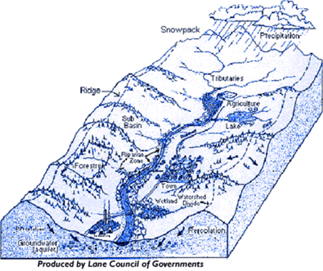
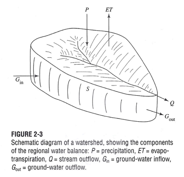
Watershed: All the land that drains into a river, lake, or other body of water. Healthy watersheds support a rich diversity of species, including humans, whose lives depend on the complex interactions between water, geology, soils, vegetation, and wildlife. The two most important functions in a watershed are the transport of water and sediment.
In the US watersheds are mapped to varying degrees of size, with cataloguing units as the smallest followed by accounting units, hydrologic subregions, and finally, hydrologic regions.
Regions (21): Contain the drainage area of a major river or the combined drainage areas of a series of rivers.
Subregions (221): Contains the area drained by a river system, a reach of a river and its tributaries in that reach, a closed basin(s), or a group of streams forming a coastal drainage area.
Accounting Units (378):
Cataloguing Units (~2000): The smallest mapped watersheds in the USA. Each has a unique address comprised of 2 digits from each of the four watershed levels, known as a Hydrologic Unit Code (HUC).
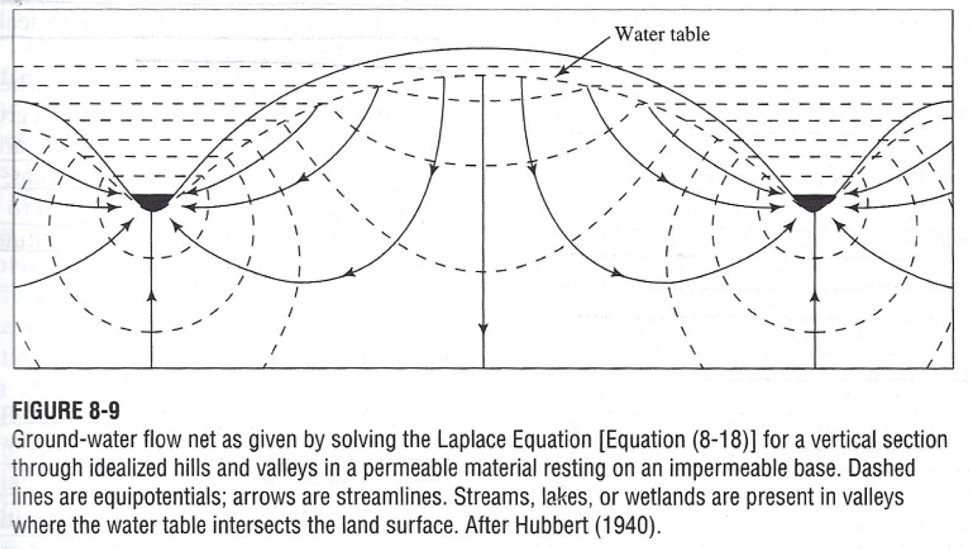
Watersheds underlain by limestone are likely to have dependable springs, well-sustained baseflow, complex patterns of ground-water surface-water interactions involving sinkholes, springs, and caves, and natural buffering against the effects of acid rain and acid mine drainage.
Watersheds with extensive surficial deposits of unconsolidated sediments such as sand and gravel are likely to have water-table aquifers that are susceptible to contamination from surface sources.
Watersheds underlain with extensive deposits of impermeable materials such as clay, and shale are likely to have low rates of infiltration and high likelihood of flooding in response to heavy rains.
In natural watersheds it is typical to see 10% of precipitation wind up as surface runoff, and 90% infiltrate into the soil to feed streams slowly via groundwater flow. In urban areas it is typical to see up to 55% of precipitation wind up as surface runoff, and only 45% infiltrate into the soil.
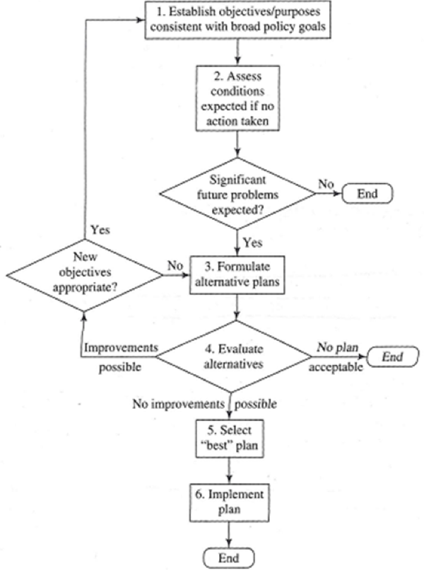
Delineating a Watershed (*Topo lines generally point upstream)
Draw a circle around a river/lake/stream/pond.
Mark the highpoints around it with an X.
Draw a line connecting the X’s while crossing through contours at right angles.
_______________________________________________________________________
Water Flow
The ability of water to pick up and carry sediment in suspension is related to the cube of the water's velocity.
During low flow, sediment tends to settle out and accumulate, and during high flows it tends to go into suspension and move.
Elements of Flow Regime: Magnitude, Duration, Frequency, Timing, and Rate of Change.
Indicators of Hydrologic Alteration (IHA): Assesses the degree to which human activities have changed flow regimes through the magnitude, frequency, duration, timing, and rate of change of flow (the five elements of flow regime).
Range of Variability Approach (RVA): Protect as much river flow as possible (Natural Flow Paradigm).
Sediment Load
Dissolved: Sediment comprised of solutes generally derived from chemical weathering of bedrock and soils.
Suspended: Sediment held aloft in the water column by turbulence; fine sands, clay, and silt.
Bed Load: Comprised of sands, gravel, cobbles, and boulders. Bed load is transported by rolling, sliding, and bouncing along the bed of the channel. Bed load influences channel morphology and stability.
Load = Concentration * Flow
Concentration: Mass of a constituent per unit volume of water, i.e. mg/L.
Load: Total mass of a constituent passing a certain point on the stream in a given time.
Total Maximum Daily Load (TMDL): An important regulatory measure; the maximum mass of a contaminant per day that a designated stream reach can absorb without harming the stream's aquatic ecosystem.
Erosion: Occurs when capacity > load.
Deposition: Occurs when capacity < load.
Equilibrium: Occurs when capacity = load.
Hungry Water: Increase in river energy downstream from river impediments that trap suspended sediment. The higher-energy, clearer flow is more erosive than sediment-laden water would be, so the bed and banks of a stream just downstream of a dam are often subject to elevated rates of erosion, and need some protection.
_______________________________________________________________________
Water Contaminants
Sediment is the most common cause of water-quality impairment and the constituent most commonly regulated in TMDL limits.
Point Source Pollution: Contaminants that enter a body of water at a specific site such as a pipe discharge.
DO Sag: Occurs when the point-source discharge of raw sewage from a small town quickly uses up all the DO in a moderate-sized stream.
Dry-Weather Point Sources: Contaminants released into a stream at a point during dry as well as wet conditions; regulated under the NPDES.
Diffuse Pollution: Contaminants that leach into a body of water as a result of rainfall, soil infiltration, and surface runoff, generally over a wide area. Includes the use of fertilizers in agriculture and forestry, pesticides from a wide range of land uses, contaminants from roads and paved areas, and atmospheric deposition of contaminants arising from industry.
Wet Weather Diffuse: Contaminants released over a large area during rainfall. Includes Urban stormwater runoff (regulated by NPDES), Acid Mine Drainage, Acid Rain, and Hg.
Combined Sewer Overflows (CSO's): Urban stormwater and raw or partially treated sewage are combined and discharged during storm events.
Dry-Weather Diffuse: Contamination from accidental and intentional spillage over a large area; includes common organic chemical contaminants, PCBs, PAHs and pesticides:
Polychlorinated Biphenyls (PCB): Act as a flame retardant in electrical equipment and have also been used in the production of inks, adhesives, sealants and caulk. Although banned in the US since 1977, the chemicals continue to enter the environment through accidental leaks, improper disposal and “legacy deposits.”
Polycyclic Aromatic Hydrocarbons (PAHs): Forms when gas, coal and oil are burned.
Pesticides: Applied to the land to prevent, destroy, repel or reduce pests. While agriculture accounts for ~75% of all pesticide use, 85% of US households store at least one pesticide at home (and more than half of US households store between 1 and 5).
Underground Leaks: Contaminations from dry-weather point, wet-weather point, or wet-weather diffuse; efforts to reduce these sources of contamination typically fall under CERCLA (Superfund), RCRA, and underground storage tank regulation.
Dissolved Oxygen (DO): O dissolved as a gas in water that is required to sustain all aquatic life. Cold water holds more DO than warm water, but even cold water can no more than ~15mg/L DO.
Most resilient streams from the standpoint of reaeration are shallow, cold, turbulent streams.
If DO falls below ~5 mg/L, some species, such as trout, must move or die. If DO falls below ~ 2mg/L, many species die. If DO falls to 0, all aquatic life except for anaerobic bacteria die.
Biological Oxygen Demand (BOD): The amount of DO consumed by aerobic bacteria in a water sample at a specific temperature over a specific time; most commonly expressed in mg-O/liter/5 days at 20C. Sewage is very rich in reduced organic matter, the leftover food not absorbed in our digestive tracts, and therefore sewage has a very high BOD.
Eutrophication: Overstimulation of algal or macrophyte plant growth in water. Occurs when the water becomes enriched with nutrients, particularly N and P.
Acid Rain: Results when sulfur dioxide (SO2) and nitrogen oxides (NOX) are emitted into the atmosphere and transported by wind and air currents. The SO2 and NOX react with water, O and other chemicals to form sulfuric and nitric acids. These mix with water and other materials before falling to the ground.
The major sources of SO2 and NOX in the atmosphere are the burning of fossil fuels to generate electricity (2/3 of SO2 and ¼ of NOX), vehicles and heavy equipment, manufacturing, oil refineries, and other industries.
Dead Zones: Form when algae die, sink to the bottom, and are decomposed by bacteria- a process that strips DO from the surrounding water; caused by excessive N and P pollution from human activities, including:
Agricultural runoff from farmland that carries nutrients from fertilizers and animal manure into rivers and streams.
Urban/suburban runoff from developed areas that washes nutrients from fertilizers, septic systems, and other pollutants into local waterways.
Wastewater treatment plants that release treated water—often still containing large amounts of nutrients—into streams and rivers.
Air pollution from our cars, factories, gas-powered tools, and power plants.
Sealcoat: The black, viscous liquid applied to many asphalt parking lots, driveways, and playgrounds in North America to protect and enhance the appearance of the underlying asphalt. Coal-tar-based pavement sealcoat is a potent source of polycyclic aromatic hydrocarbon (PAH) contamination in urban and suburban areas and a potential concern for human health and aquatic life.
_______________________________________________________________________
Soil
Among the characteristics by which soils are infiltration capacity and frequency of inundation.
Universal Soil Loss Equation (USLE): Rate of soil loss from disturbed areas; predicts the long-term average annual rate of soil erosion; A = R x LS x C x P.
A: the long term average annual soil loss (in tons per hA per year).
R: The erosion potential, dependent on the rainfall and runoff of the region.
K: The soil erodibility factor, primarily dependent on soil texture.
LS: The steepness and length of the slope.
C: The crop type and tillage method.
_______________________________________________________________________
Watershed Law
Common Law: Long before there was a Congress to enact legislation, the basic rules of civil society in England were gradually assembled together into the Common Law, which is based largely on previous decisions made in similar cases. The Common Law recognizes rights of individuals, and thus includes a long history of decisions in tort cases where one party sues for damages caused by another.
Riparian Doctrine: The owner of any land adjacent to a stream has the right to draw water from the stream for a beneficial use. In times of drought, all water users are expected to suffer equally in diminished access to water. This doctrine formed the basis for water law in most of the humid eastern part of the US.
Prior Appropriation Doctrine: First in time, first in right. No matter who owns the land, the first person divert water from a stream and put it to beneficial use has the most senior right to use that water. Each successive person who diverts water from the same source has a successively junior water right. Those with senior water rights are entitled to their full share even when others do not get water. Those with the most junior rights frequently get no water, except during abnormally wet years. The basis for water law in the arid W. US.
Law of the Biggest Pump: Landowners can pump as much ground water as they wish from beneath their land, no matter how it affects their neighbors (TX).
_______________________________________________________________________
US Water Acts
Clean Water Act (CWA): Passed by the USG in 1972, requiring the EPA to work with the states to compile and update a list of impaired waters, and to produce periodic reports on a national water quality inventory. Major provisions of the CWA include:
A permit system for all industrial and municipal wastewater discharges. This system was called the National Pollutant Discharge Elimination System (NPDES) because its original goal was to eliminate the discharge of pollutants by 1985 as a result of anticipated new treatment and water-use technology.
Controls on accidental or intentional spills and releases of pollutants.
Prohibitions and permit requirements for dredging and filling waterways and wetlands (administered by the Corps of Engineers).
Grants to communities and states to help build wastewater treatment systems.
State programs to control point and non-point pollution in watersheds.
State programs to assess and report on water quality.
National Environmental Policy Act (NEPA): Passed in 1969 to require environmental impact statements (EIS) for legislation and major federal actions. EIS must describe the environmental consequences of taking the proposed action, often with separate descriptions of consequences for various alternatives of the proposed action, AND the consequences of taking no action.
Safe Drinking Water Act (SDWA): Passed in 1974 and sets forth EPA overseen primary and secondary standards for drinking water, and provides grants and loans for communities and states to improve drinking-water treatment plants.
1996: The USG passes an amendment to the SDWA, requiring states to develop a source-water assessment for each public water supply system in the state. The assessment has to provide, for each system, a delineation of the source area (watershed or well capture area), an inventory of potential sources of contamination in the source area (including permitted waste discharges, agricultural operations, landfills, hazardous waste storage areas, urban and industrial areas, etc.), and an analysis of the vulnerability of the system to contamination from those potential sources of contamination.
Resource Conservation and Recovery Act (RCRA): Passed by the USG in 1976; sets forth policies designed to prevent soil and ground-water contamination by hazardous wastes, by ensuring that toxic wastes are handled differently from normal domestic refuse.
Comprehensive Environmental Response, Compensation, and Liability Act (CERCLA, ‘Superfund’): Passed by the USG in 1982, sets forth rules designed to identify parties responsible for soil and water contamination by hazardous wastes and force them to cover costs for remediation. It also sets up a fund to cover remediation with Federal dollars when sufficient funding cannot be recovered from the responsible parties.
Soil Conservation Act: Passed by the USG in 1935 during the Dust Bowl to create the Soil Conservation Service (now known as the Natural Resources Conservation Service), and establish a system for the development of soil and water conservation districts at the county level throughout the country. In these districts, farmers, ranchers, other private landowners, and various levels of government work together to improve farming practices to reduce soil erosion, create buffers to reduce sediment transport to streams, and take other measures to promote healthy watersheds.
_______________________________________________________________________
Watershed Best Practices
Design best management practices (BMPs) for pollutant removal, GW recharge, and stream channel protection.
More Development means more runoff means higher flow velocities and increased pollution and less infiltration. Pollutants runoff into local streams and rivers impacting aquatic life, eroding streams by high volumes and flows, and flooding natural drainage systems.
The Keys to effective stormwater management are:
Reducing imperviousness
Controlling pollutants
Protecting streams from excessive erosion
Nonstructural BMPs
Reduce impacts to water quality
Reduce runoff volume
Reduce flow velocity and erosive discharges
Use natural pollutant removal mechanisms
Provide credits for conserving natural areas, rooftop runoff disconnection- directing rooftop runoff to pervious areas, non-rooftop disconnection- sheet flow, raingardens.
Structural BMPs
Stormwater ponds (min 10 acres) and wetlands.
Infiltration practices (underlying soil must be suitable with infiltration rate (f) >= .52”/hr- loams, sand loams, loamy sands, and sands). GW must be >4’ below and 100’ horizontally from water supply wells.
Filtering systems (max 10 acres).
Introduce oysters to improve water quality.
An acre of restored oyster reef could remove nearly 500 pounds of N from the water per year.
Oysters filter the water above them and consume the phytoplankton and other bits of organic matter. Some of the N in the plants ends up in the oyster itself or in its shell, and the rest gets excreted and lands on the sediment around the reef. Once there, aerobic bacteria living in the top layer of sediment and anaerobic bacteria deeper down transform the N in a series of steps that end with some of it being released as N gas, the most abundant element in the air we breathe.
Engineers at Rice University's Nanotechnology Enabled Water Treatment (NEWT) Center have found a catalyst that cleans toxic nitrates from drinking water by converting them into air and water. In 2013, his group showed that tiny gold spheres dotted with specks of palladium could break apart nitrites, the more toxic chemical cousins of nitrates. we found that covering about 40 percent of a palladium sphere's surface with indium gave us our most active catalyst. the Rice team found that the indium speeds up the breakdown of nitrates while the palladium apparently keeps the indium from being permanently oxidized.
Most erosion occurs when rain falls on bare ground exposed by the tillage of cultivated crops. The most important step In general, the most important step in restoring a watershed that is undergoing severe erosion is to stabilize the soil.
Conservation Tillage: Leaving crop residue (plant materials from past harvests) on the soil surface reduces runoff and soil erosion, conserves soil moisture, helps keep nutrients and pesticides on the field, and improves soil, water, and air quality.
Crop Nutrient Management: Fully managing and accounting for all nutrient inputs helps ensure nutrients are available to meet crop needs while reducing nutrient movements off fields. It also helps prevent excessive buildup in soils and helps protect air quality.
Pest Management: Varied methods for keeping insects, weeds, disease, and other pests below economically harmful levels while protecting soil, water, and air quality.
Conservation Buffers: From simple grassed waterways to riparian areas, buffers provide an additional barrier of protection by capturing potential pollutants that might otherwise move into surface waters.
Irrigation Water Management: Reducing nonpoint source pollution of ground and surface waters caused by irrigation systems.
Grazing Management: Minimizing the water quality impacts of grazing and browsing activities on pasture and range lands.
Animal Feeding Operations (AFOs) Management: Minimizing impacts of animal feeding operations and waste discharges through runoff controls, waste storage, waste utilization, and nutrient management.
Erosion and Sediment Control: Conserving soil and reducing the mass of sediment reaching a water body, protecting both agricultural land and water quality and habitat.
Prior to the late 1970s urban stormwater management focused on reducing localized flooding caused by the artificially heightened storm runoff hydrographs. The preferred solution was to put surface runoff in underground pipes or straightened, concrete-lined channels (like the L.A. River) and convey the runoff to nearest river as quickly as possible. In the late 1970s the EPA conducted a study of urban waterways. They found that urban storm runoff typically contains a wide range of pollutants in significant concentrations, including metals, oils, nutrients, bacteria, and other pollutants. This led to a new paradigm for urban stormwater management, in which the emphasis is on reducing both flow and pollution; bioretention (rain gardens), permeable pavement, disconnected impervious areas, rain barrels/cisterns, green/blue roofs, street planters, and infiltration basins.
Flow Management
Statistically characterize the natural range of streamflow variation.
Select numerical flow management targets, based upon natural flow regime characteristics.
Design a management system or restoration program that will enable attainment of flow targets.
Implement an ecosystem monitoring and research program based on the uncertainty of flow targets and response of ecosystem to management actions.
Review and revise monitoring and research results on an annual basis (at least).
Modify management or restoration program as suggested by monitoring and research results. Management system must be designed with adaptive capabilities from the start.
_______________________________________________________________________
Chesapeake Bay
Chesapeake Bay: Largest Estuary in the USA.
Estuary: A semi-enclosed body of water where freshwater and saltwater mix.
Chesapeake Bay Issues: Submerged aquatic vegetation, intersex fish in tributary rivers, combined sewer overflows in tributaries, nutrients, pesticides, toxics, airborne pollutants, and overharvesting of sport and commercial fisheries.
Eutrophication: The rapid growth of algae in waterways; Algal blooms increase turbidity and prevent sunlight from reaching submerged aquatic vegetation, one of the foundations of the Bay’s food web. Algal blooms also deplete dissolved oxygen when the algae die and decompose. The reduction in dissolved oxygen concentrations creates temporary dead zones within the Bay, where there is little or no dissolved oxygen. The only life that can survive in these dead zones is anaerobic bacteria.
Keys to Restoration
Increased public awareness, public education and involvement programs.
Increased recreational use of the river.
Implementation of improved technology.
Availability of funding from public and private sources.
Involvement of a wide range of governmental and non-governmental entities in coalitions.
Increased monitoring to inform managers of the status of the watershed.
Studies to help define the problems and outline solutions.
Oysters are filter feeders, drawing in water to filter out small organisms for their food, and expelling the filtered water. It has been estimated that in pre-colonial times oysters could filter the entire volume of the Bay in 3.3 days. By 1988 that time had increased to 325 days.
_______________________________________________________________________
Resources
Envirofacts (EPA): Environmental Facts Database; https://enviro.epa.gov/
Environmental Health Program (USGS): https://www.usgs.gov/programs/environmental-health-program
How’s My Waterway (EPA): Status of US waterways; https://mywaterway.epa.gov/state
National Center for Environmental Information (NOAA): https://www.ncei.noaa.gov/
National Geologic Map Database (USGS): https://ngmdb.usgs.gov/ngmdb/ngmdb_home.html
National Hydrography Dataset (NHD) (USGS): A digital representation of the Nation's surface-water network; https://www.usgs.gov/national-hydrography/national-hydrography-dataset
National Hydrography Products (USGS): https://www.usgs.gov/national-hydrography
National Map: https://apps.nationalmap.gov/viewer/
National Water Quality Assessment (NAWQA) (USGS): https://www.usgs.gov/mission-areas/water-resources/science/national-water-quality-assessment-nawqa
North American Drought Monitor (NADM) (NOAA): US, Canada, Mexico Drought Monitor; https://nadm-noaa.hub.arcgis.com/
River Network: Connecting people to their local rivers; https://www.rivernetwork.org/
Science in your Watershed (USGS): https://water.usgs.gov/wsc/trilogy.html
Sparrow Modeling (USGS): Estimating nutrient, sediment, and dissolved solids transport; https://www.usgs.gov/mission-areas/water-resources/science/sparrow-modeling-estimating-nutrient-sediment-and-dissolved?qt-science_center_objects=0#qt-science_center_objects
Topo Maps (USGS): https://ngmdb.usgs.gov/topoview/
US Drought Monitor: https://droughtmonitor.unl.edu/
US Water Monitor (USGS): https://watermonitor.gov/
Water Data for the US (USGS): https://waterdata.usgs.gov/nwis/
Water Quality Data (EPA): https://www.epa.gov/waterdata/water-quality-data
Water Watch (USGS): Near real time US water data; https://waterwatch.usgs.gov/
Watershed Boundary Dataset (USGS): https://www.usgs.gov/core-science-systems/ngp/national-hydrography/watershed-boundary-dataset?qt-science_support_page_related_con=4#qt-science_support_page_related_con
Web Soil Survey (USDA): https://websoilsurvey.nrcs.usda.gov/app/
_______________________________________________________________________
Terminology
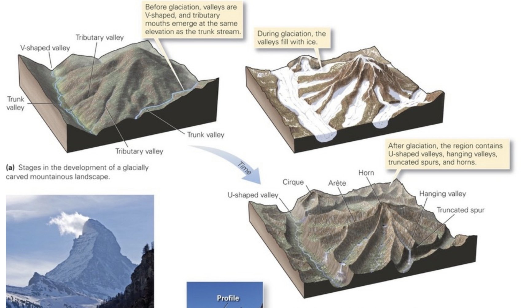
Fjord: A drowned glaciated river valley.
Ria: A drowned, non-glaciated river valley.
Ridge (or divide): Separates two adjacent drainages.
Southern Oscillation (SO): The atmospheric component of ENSO; refers to a “seesaw” effect in sea-level pressure between the tropical Pacific and Indian Oceans. Reduced sea-level pressure in the Pacific combined with increased sea-level pressure in the Indian Ocean leads to a weakening in the trade winds over the E. Pacific. This weakening enables warm water from the central equatorial Pacific to spread eastward and southward along the west coast of South America, creating the classic El Niño condition. Conversely, and about as frequently, the sea-level pressure in the Pacific Ocean increases while pressure in the Indian Ocean decreases, which causes trade winds to intensify over the eastern Pacific. When this occurs, equatorial upwelling of deep, cold water and cold water from the west coast of South America are pulled northward and westward from the coast into the eastern and central Pacific, producing La Niña. Thus, El Niño and La Niña are, respectively, the warm and cold phases of the coupled ENSO system.
Trade Winds (Easterlies): The permanent E to W prevailing winds that flow in the Earth’s equatorial region. They are called “Easterlies” because they originate in the East.
_______________________________________________________________________
Chronology
1996: The USG passes an amendment to the SDWA (1974), requiring states to develop a source-water assessment for each public water supply system in the state. The assessment has to provide, for each system, a delineation of the source area (watershed or well capture area), an inventory of potential sources of contamination in the source area (including permitted waste discharges, agricultural operations, landfills, hazardous waste storage areas, urban and industrial areas, etc.), and an analysis of the vulnerability of the system to contamination from those potential sources of contamination (JHU Watersheds, Patterson).
1991: The Southern Nevada Water Authority (SNWA) is founded and begins initiatives for conserving water (JHU Watersheds, Patterson).
1987: The Rhine Action Programme of 1987 (aka Salmon 2000) is passed with the stated target of returning salmon to the Rhine by the year 2000 (JHU Watersheds, Patterson).
1983: The Chesapeake Bay Agreement is signed establishing the Chesapeake Bay Program (https://www.chesapeakebay.net/) as a collaborative effort involving 6 states, DC, EPA, and the Chesapeake Bay Commission, with specific goals to restore the bay (JHU Watersheds, Patterson).
1982: The USG passes the Comprehensive Environmental Response, Compensation, and Liability Act (CERCLA, ‘Superfund’), setting forth rules designed to identify parties responsible for soil and water contamination by hazardous wastes and force them to cover costs for remediation. It also sets up a fund to cover remediation with Federal dollars when sufficient funding cannot be recovered from the responsible parties (JHU Watersheds, Patterson).
1977: The US bans Polychlorinated Biphenyls (PCBs), used as a flame retardant in electrical equipment and in the production of inks, adhesives, sealants and caulk (JHU Watersheds, Patterson).
1977: The USG passes the Surface Mining Control and Reclamation Act in response to significant environmental damage caused by surface mining (strip-mining) of coal in the Appalachians and Rocky Mountain states. The act requires certain actions to restore and remediate natural resources damaged by surface mining (JHU Watersheds, Patterson).
1976: The USG passes the Resource Conservation and Recovery Act (RCRA), which sets forth policies designed to prevent soil and ground-water contamination by hazardous wastes, by ensuring that toxic wastes are handled differently from normal domestic refuse (JHU Watersheds, Patterson).
1974: The USG passes the Safe Drinking Water Act (SDWA) setting forth EPA overseen primary and secondary standards for drinking water, and providing grants and loans for communities and states to improve drinking-water treatment plants (JHU Watersheds, Patterson).
1969: The USG passes the National Environmental Policy Act (NEPA), requiring environmental impact statements for major federal projects. EIS must describe the environmental consequences of taking the proposed action, often with separate descriptions of consequences for various alternatives of the proposed action, AND the consequences of taking no action (JHU Watersheds, Patterson).
27 Apr, 1935: The USG under POTUS FDR passes the Soil Conservation Act creating the Soil Conservation Service (now the Natural Resources Conservation Service) to establish a system for the development of soil and water conservation districts at the county level throughout the country. In these districts, farmers, ranchers, other private landowners, and various levels of government work together to improve farming practices to reduce soil erosion, create buffers to reduce sediment transport to streams (JHU Watersheds, Patterson).
1913: The 238-mile Owens Valley Aqueduct is completed reaching into Mono Basin (it has been expanded 3x since). By the 1920’s, Mono Lake was almost entirely dry (JHU Watersheds, Patterson).
1911: Las Vegas (Fertile Meadows- Spanish) is founded as a stopover for traders traversing the region (JHU Watersheds, Patterson).
1899: The USG passes the River and Harbors Act granting authority to the US Army Corps of Engineers regulatory permit program to protect navigable waters in the development of harbors and other construction (JHU Watersheds, Patterson).
1872: The USG passes the Mining Act allowing for transfers of public land containing hardrock minerals to private ownership merely in exchange for the filing of a claim and some evidence of effort to extract the minerals. Corporations are allowed to purchase such land at the 1872 price of $5 per acre (JHU Watersheds, Patterson).
10 Ka: Ice age Ice sheets recede leaving rock scars and filling pluvial lakes in cirques, basins, and other general low points including the Great Basin, Death Valley. Lake Bonneville, for example, was around 300 m deep at its crest and covered hundreds of miles (Dutch, 1999). Over time the climate changed for the drier, these glacial lakes disappeared (JHU Watersheds, Patterson).
18 Ka: Ice Sheets peak during the last Ice Age, reaching down from the poles to almost as far south as the OH River in the US Midwest (JHU Watersheds, Patterson).
2.6 Ma- 10Ka: Earth’s Sea levels are ~110m lower than today (JHU Watersheds, Patterson).
35 Ma: A large meteorite strikes the shallow Atlantic Ocean near the mouth of today’s Chesapeake Bay (JHU Watersheds, Patterson).
340 Ma: The Antler Orogeny in the Great Basin; the Antler Arc terrane collides with the N American plate, creating mountains near the modern Great Basin. The mountain range slowly erodes and the sea returns (Blakely, 2006).
_______________________________________________________________________
---Articles---
_______________________________________________________________________
Assessment of the Hydraulic Connection between GW and the Peace River by USGS
Ref: USGS (1998). Assessment of the hydraulic connection between ground water and the Peace River, west-central Florida. vi, 96 p. :ill., maps ;28 cm. DOI: 10.3133/wri974211
Along the upper Peace River, a progressive long-term decline in streamflow has occurred since 1931 due to a lowering of the potentiometric surface of the Upper Floridan aquifer by as much as 60 feet because of intensive GW withdrawals for phosphate mining and agriculture. Another effect from lowering the potentiometric surface has been the cessation of flow at several springs located near and within the Peace River channel, including Kissengen Spring, that once averaged a flow of about 19M gallons a day. The lowering of GW head resulted in flow reversals at locations where streamflow enters sinkholes along the streambed and floodplain.
_______________________________________________________________________