Hiking the Southwest's Geology by Hopkins
Ref: Ralph Hopkins (2002). Hiking the Southwest’s Geology, Four Corners Region. The Mountaineers Publishing.
___________________________________________________________________________
Summary
A geologic history of the Colorado Plateau.
Colorado Plateau: The geologic province in the Four Corners region of the SW US characterized by uplifted, flat-lying sedimentary layers dissected by the CO River and its tributaries.
The unusual colorful hues in the CO Plateau’s rocks are the result of small amounts of oxide minerals trapped in the rock. Oxides are formed when metals like Fe and Mn combine with O. In general, Fe-Oxides tend to stain the rock varying shades of red and yellow, while Mn-oxides add pastels like purple and lavender. Similar to rust, red Fe-oxide minerals- most commonly hematite- coat individual grains within a rock, or are precipitated within the chemical cement (calcite or quartz) that binds the rock together. It only takes tiny amounts of hematite within the rock, typically less than 3-5%, to color the rock’s red.
___________________________________________________________________________
Introduction
Sedimentary Rocks: Rocks composed of fragments or grains of older rocks- mud, sand, gravel, or the skeletal remains of organisms such as shells and coral. These sediments were transported or deposited in layers by the actions of water and wind. Common sedimentary rocks include limestone, sandstone, shale, and conglomerate.
Sandstone: A type of sedimentary rock composed primarily of quartz.
Shale: A type of sedimentary rock composed of both siltstone and mudstone (accumulations of silt and clay). Shales result in low energy environments where silt and mud settle, like river floodplains, coastal tide flats and lagoons, and deeper water environments offshore.
Limestone: A type of sedimentary rock comprised of the remains of organisms such as shells and corals.
Conglomerates: A type of sedimentary rock composed of mixtures of coarse-grained sediments like pebbles, cobbles, and boulders cemented together by quartz or calcite minerals precipitated in the spaces between the particles.
With gentle cooking, existing mineral grains enlarge and become fused. In this way, the sedimentary rock shale transforms into the metamorphic rock slate, sandstone transforms into quartzite, and limestone transforms into marble. As temperature and pressure intensify, the alignment of the minerals becomes more pronounced, which further transforms the rock. This is what happens when slate is altered to schist. If conditions further intensify, the minerals in schist may segregate into light and dark layers to form the metamorphic rock gneiss.
The continental margin of Western North America is a mosaic of fragments, or microplates, added to the continent during phases of its assembly. This process, called continental accretion, in its early phases helped build the basement foundation for the CO Plateau. As accretion continued, the volcanic and sedimentary rocks along this ancient continent were intensely metamorphosed into schist and gneiss. These rocks became part of N. America’s Pre-Cambrian basement rock, and include the Grand Canyon’s 1.7B-yo Vishnu Schist.
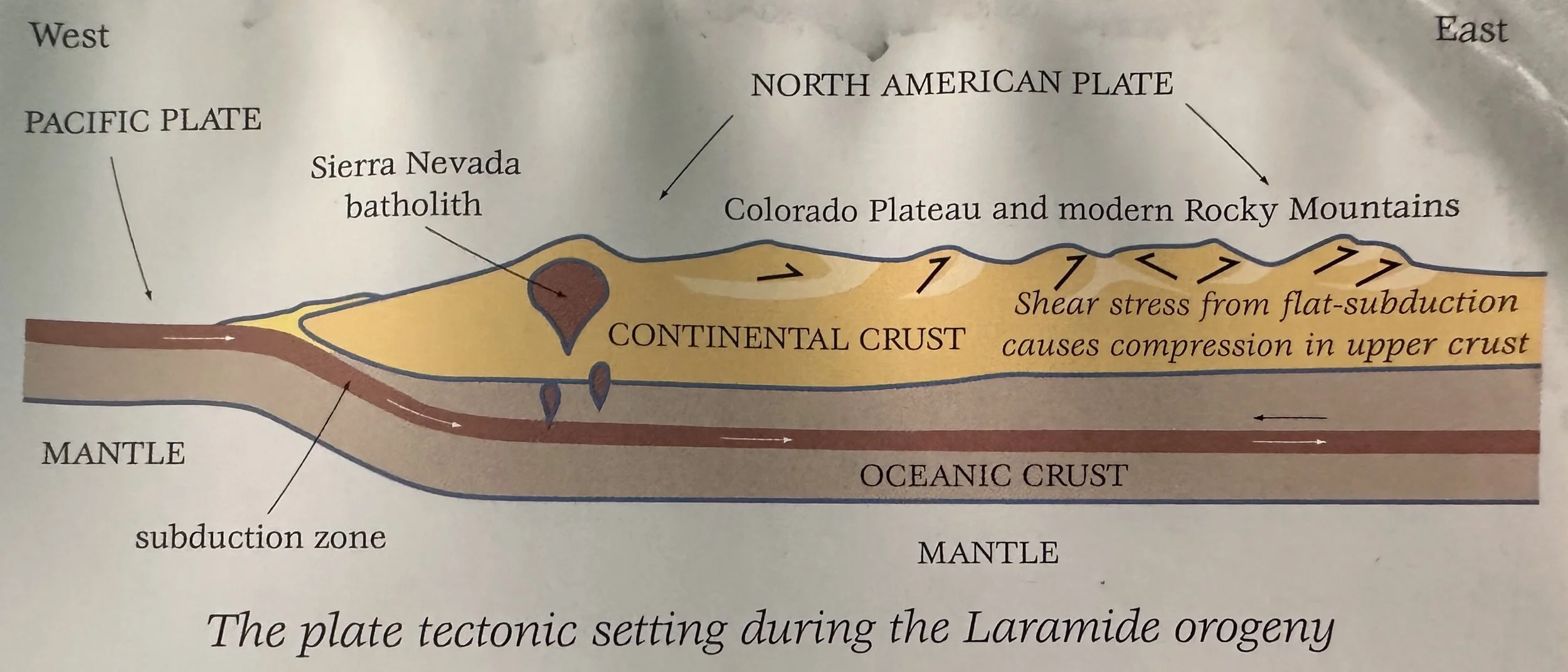
Geologists speculate that about 65 Ma the pace of Atlantic sea-floor spreading may have quickened, accelerating the rate of subduction of the Pacific Sea floor beneath North America. This may have flattened the angle of subduction, causing the Pacific Plate to impinge on the region's basement rocks. The basement squeezed like an accordion, sending some rocks skyward to become mountains (as in Colorado).
___________________________________________________________________________
Arizona’s Plateau Hikes
Pre-Cambrian continents collided to form the twisted igneous and metamorphic roots of the North American continent. These rocks include the Vishnu Schist and Zoraster granite, which are part of the ancient 1.7B yo basement rocks that underlie the CO plateau.
More than 150 lava flows have poured into the western Grand Canyon over the last 1.5 My. Some of these flows stretch for over 80 miles downcanyon from their source. Perhaps as many as 12 times, great dams of lava were constructed in the canyon bottom, effectively blocking the flow of the Colorado River and forming a temporary lake. As the lake behind the dams overflowed, an incredible waterfall spilled downstream carving a new gorge and leaving only remnants of basalt clinging to the walls of the canyon. Later eruptions built new dams, which in turn were also breached and destroyed by the power of the Colorado River.
Petrified Forest: The majority of fossil logs in the Petrified Forest are pine-like conifers of the extinct genus Araucarioxylon. They were similar to the "monkey puzzle" trees (Araucaria) that today grow natively in the warm, temperate parts of South America, Australia, and New Zealand. Other plant fossils found in the Chinle Formation include a variety of ferns, giant horsetails (which grew to 10m tall), and microscopic spores and pollen that tell a great deal about the types of plants living here over 200 Ma. As you make your way around the loop, look closely at some of the amazing specimens of fossil wood, some displaying a rainbow of colors. The vivid colors are caused by trace elements trapped in the quartz minerals that "petrified" the original wood. Amazingly, only trace amounts of iron (and in some cases manganese) in the quartz is responsible for the great variety of colors, including red, yellow, brown, and even blue. The great amounts of silica needed for the fossilization process (the critical ingredient for making quartz is SiOz) was supplied by the volcanic ash that wafted across the Chinle rivers and floodplains during the Triassic. Once the trees were buried by overlying sediment, the silica from the volcanic ash was dissolved into the groundwater, which then soaked into the wood where it precipitated and fossilized the ancient trees.
___________________________________________________________________________
Utah’s Plateau Hikes
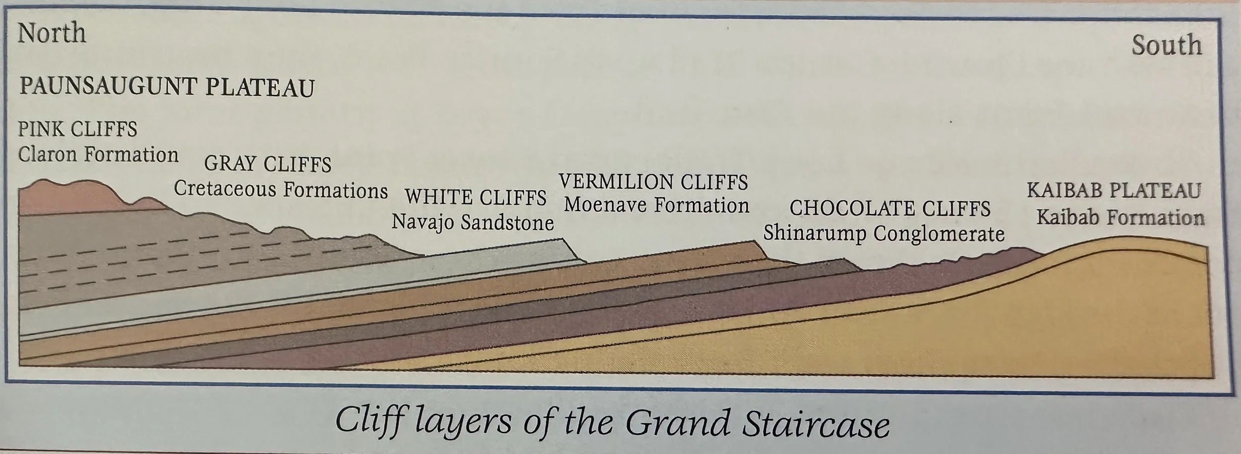
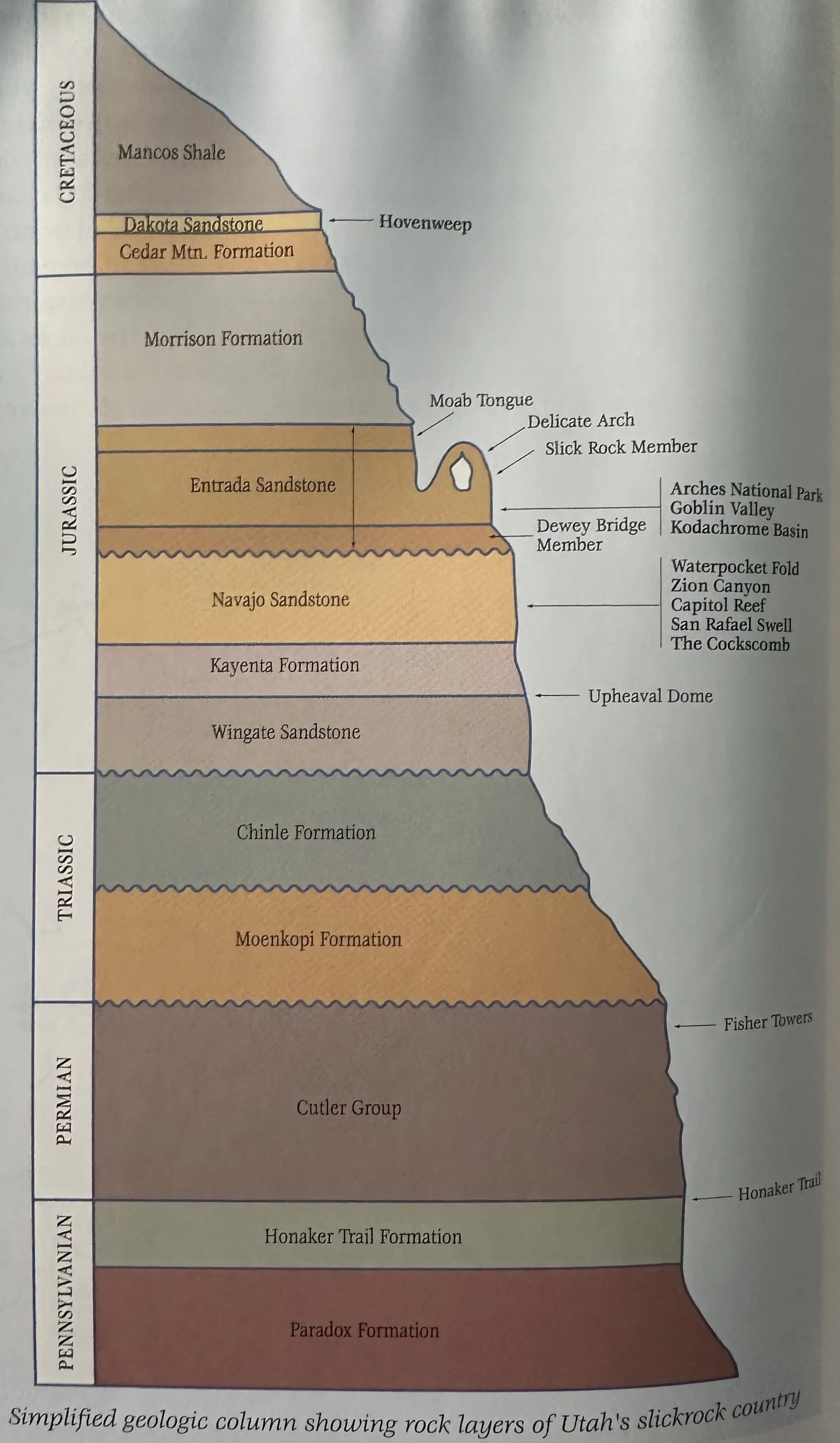
Topping the "who's who" list of the slickrock formations in the Navajo Sandstone are the massive cliffs in Zion National Park, the majestic domes along Capitol Reef's Waterpocket Fold, and the twisting Escalante Canyon-lands of the Grand Staircase-Escalante National Monument. The sandstone fins and arches in Arches National Park, the bizarre hoodoos of Goblin Valley, and the curious sandstone pipes of Kodachrome Basin are all worn from another marquee name —the Entrada Sandstone. And there is also the prominent Wingate Sandstone, known for expansive sheer cliffs that edge many of the mesas, including Canyonlands' Island in the Sky. All three of these formations are part of the Jurassic "sand pile" of wind-blown dunes that swept the Colorado Plateau between about 200-175 Ma.
Delicate Arch: A freestanding sandstone sculpture clinging precariously to the sloping lip of a large stone amphitheater. Like other arches in the park, Delicate Arch is constructed in the colorful wind-blown layers of the Jurassic Entrada Sandstone. Situated high above Cache Valley- a collapsed salt anticline, and set against the perfect background of the La Sal Mountains- a laccolith, the view from Delicate Arch is a shrine for geologists and photographers alike.
La Sal (‘Salt’) Mountains: A laccolith which formed when magma intruded through the sedimentary layers of the Colorado Plateau between 25-28 Ma. As the Colorado Plateau has slowly uplifted over the last 10 My, these resistant igneous rocks have been revealed by erosion as the overlying sedimentary strata have worn away.
From the position of the Lava Point flows high above today's canyon floor, geologists have estimated the rate of canyon-cutting in the Zion Canyon region at about 1300’ per My (1.3’ per thousand years). Thus, just 1 million years ago, the main canyon through Zion National Park was about half as deep as it is today and the famous "Narrows" in the upper canyon had not yet formed. Since the Navajo Sandstone is over 2000’ thick, this means the canyons of Zion that we see today were carved in "only" the last 2 My.
___________________________________________________________________________
Colorado’s Plateau Hikes
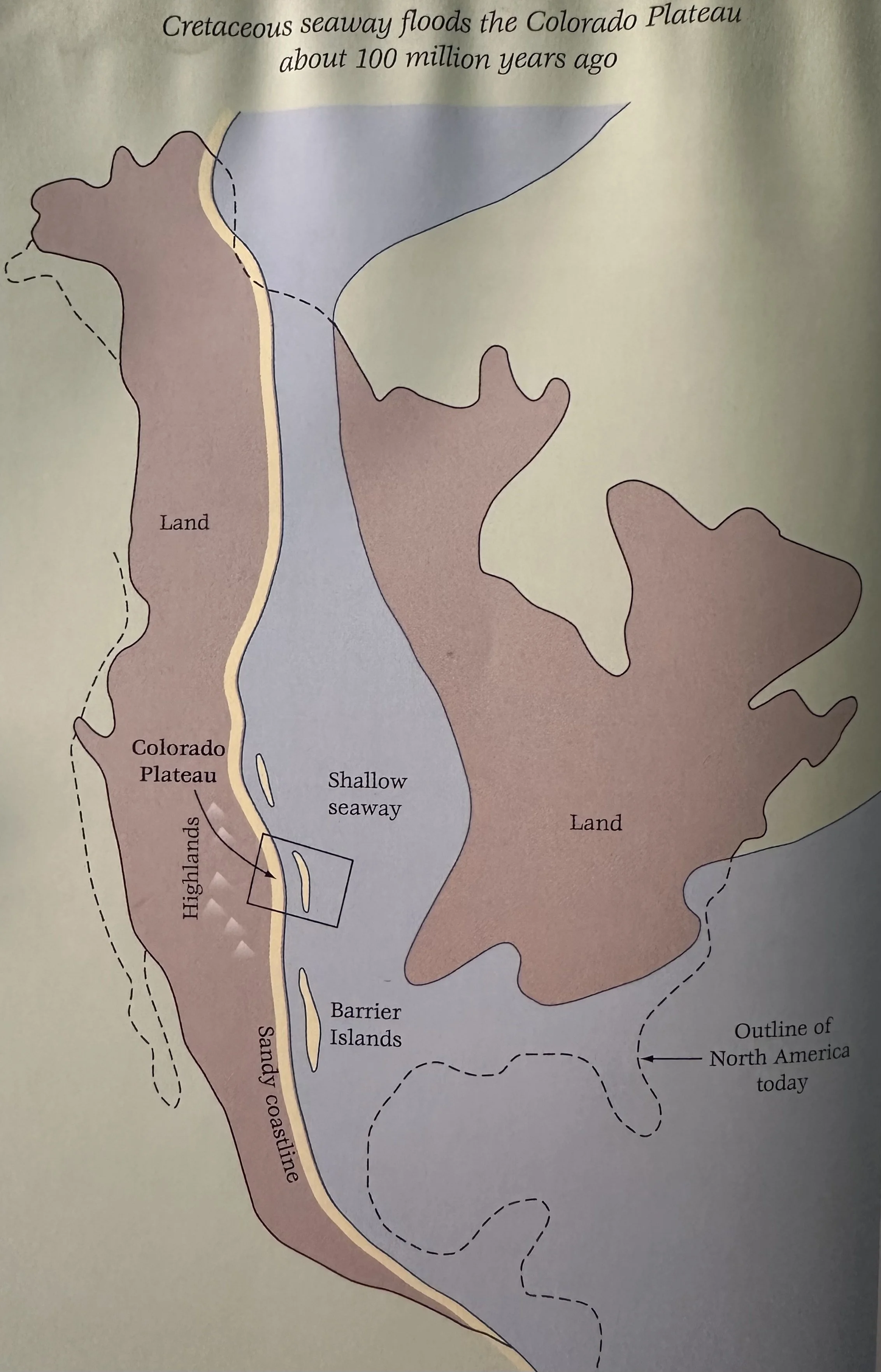
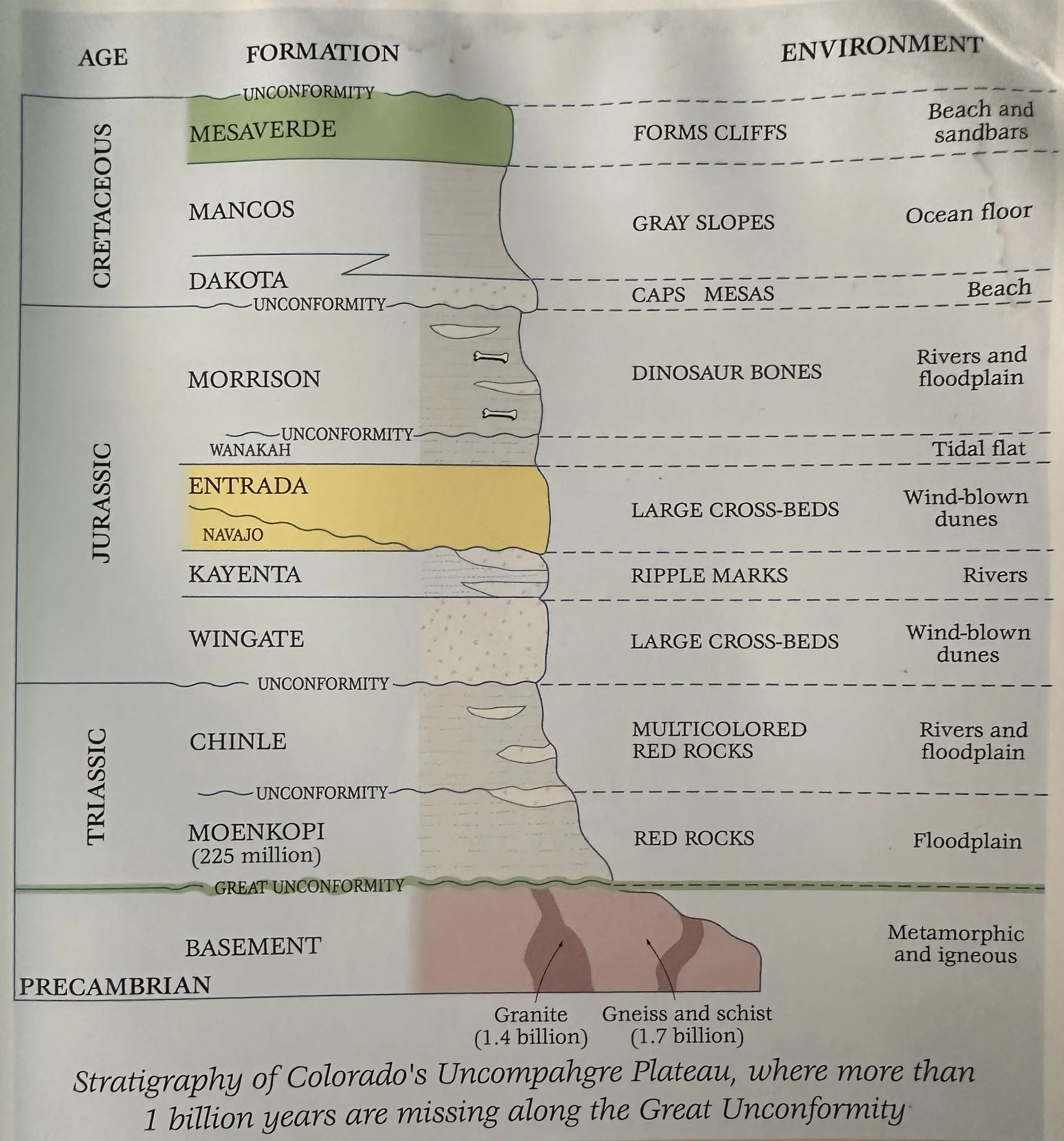
Mesa Verde: A deeply dissected plateau of Cretaceous sedimentary rock that dominates the landscape in the Four Corners region of SW Colorado. It is a relic of a past landscape connected to the lower reaches of the La Plata and San Juan Mountains. Erosion along its north rim separated Mesa Verde from the mountains. Isolated now, it stands >600m above Montezuma Valley to the north. This plateau is most famous for housing the largest Ancestral Puebloan cliff dwellings in the SW. Apart from these spectacular cliff dwellings, the most prominent feature of Mesa Verde is the resistant, massive sandstone cliff that forms the N. edge of the plateau. This imposing cliff is made of the Cretaceous Mesaverde Group, a sedimentary sequence that records the retreat and advance of a vast inland sea which extended from TX and Mexico N. to the Arctic Ocean. Between 100 and 70 Ma, the Cretaceous seaway repeatedly submerged the Colorado Plateau.
___________________________________________________________________________
New Mexico’s Plateau Hikes
___________________________________________________________________________
Misc Quotes
“Earth is very thin, like crackers on top of a huge cauldron of pea soup.”
___________________________________________________________________________
Terminology
Ancestral Rocky Mountains: Ancient basement-cored mountains (the Uncompahgre Highland) and uplifts (Defiance uplift) that rose 300 Ma, warping overlying sedimentary layers.
Anticline: An upward fold in rock layers; arched or dome-like uplift of sedimentary layers.
Basement Rock: A general term for the oldest rocks of Pre-Cambrian age; generally, gneiss, schist, and granitic rocks.
Basin & Range: A vast tectonic province that continues west across UT into NV and CA, and south into AZ and Mexico that is characterized by fault-block mountains separated by down-dropped basins. The basin and range borders the CO Plateau on the south and west.
Cinder Cones: Small volcanoes built of tiny fragments of basalt ejected from a central vent during an explosive volcanic eruption.
Colorado Plateau: The geologic province in the Four Corners region of the SW US characterized by uplifted, flat-lying sedimentary layers dissected by the CO River and its tributaries.
Continental Accretion: Growth or increase in size of a continent by collision of plates that then become part of the continental mass; the process often results in mountain building and intense metamorphism.
Cretaceous Seaway: A shallow inland sea that stretch from the Arctic to the Gulf of Mexico and flooded the Colorado Plateau about 100 Ma.
Diatreme (Volcanic Neck): Eroded pipes or conduits formed during explosive volcanic eruptions.
Differential Erosion: The varying rates of weathering, most common in sedimentary rocks, where some areas or layers of rock are more resistant than others.
Erosion: The physical breakup or removal of rock by an agent such as running water, glacial ice, or wind.
Fault- Block: An uplifted section of rock bounded on either side by faults.
Fault: A break in rocks where movement has occurred.
Graben: A down-dropped block of rock bounded on either side by faults.
Hanging Valley: A valley whose floor is high above a main valley; usually formed where a small glacier once met a large glacier.
Headward Erosion: A weathering process that lengthens a valley in an uphill or upstream direction.
Hurricane Fault: Marks the boundary between the Colorado Plateau and the Basin and Range. The fault continues to be active today and presents a serious threat for future earthquakes.
Laccolith: An igneous intrusion that squeezes between sedimentary layers and domes up the overlying layers.
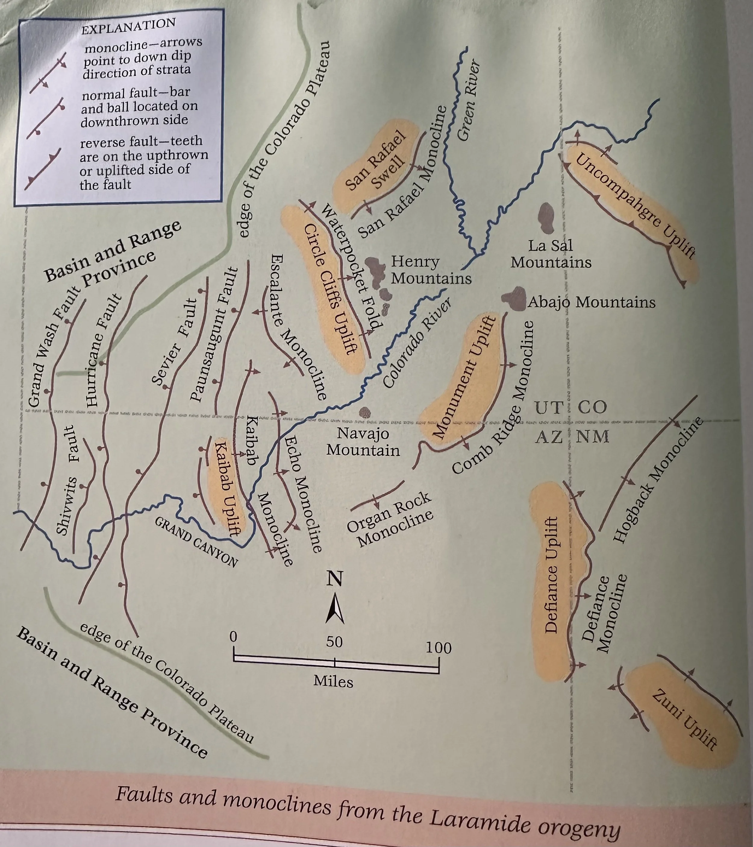
Laramide Orogeny: A major uplift and mountain building event between ~65-50 Ma when huge blocks of basement rocks pushed up from below warping overlying sedimentary layers into steep monoclines and broad anticlines.
Mogollon Highlands: An ancient mountain range that existed South of the Colorado Plateau and shed a tremendous amount of sediment to the North; presumable uplifted ~300 Ma with the ancestral Rocky Mountains and again in the Mesozoic.
Mogollon Rim: A topographic feature defined by a series of cliffs or escarpments which represents the Southern edge of the Colorado Plateau.
Monocline: A bend in rock layers where all strata are inclined in the same direction; step-like fold in rock.
Natural Arch: Natural openings or rock spans with at least 1m of uninterrupted space through which light can pass. Natural arches form by frost action and erosion by moisture and wind and are most common in sedimentary rocks, typically sandstone. Three primary ingredients are required for the formation of natural arches- first, the rocks must erode into narrow vertical walls, or fins, second- the rocks involved must be strong enough to support their own weight if the underlying rocks to the sides are removed, and third- arches typically form where a porous sandstone layer overlies a less permeable shale or siltstone layer.
Natural Bridge: Form as a stream undercuts the neck of a large bend or meander along its course. Armed with tons of grit (i.e., sand, silt, and boulders), the stream continues its work undermining the canyon wall. Over time the river breaks through the canyon wall, creating a "shortcut" downstream and abandoning the old meander loop, leaving it high and dry. Slowly, with the help of continued undercutting by the stream and erosion by moisture from within the rock, the opening in the canyon wall is enlarged, and a bridge is formed.
Normal Fault: A fault caused by extension in which the block above the fault plan has moved down relative to the other block.
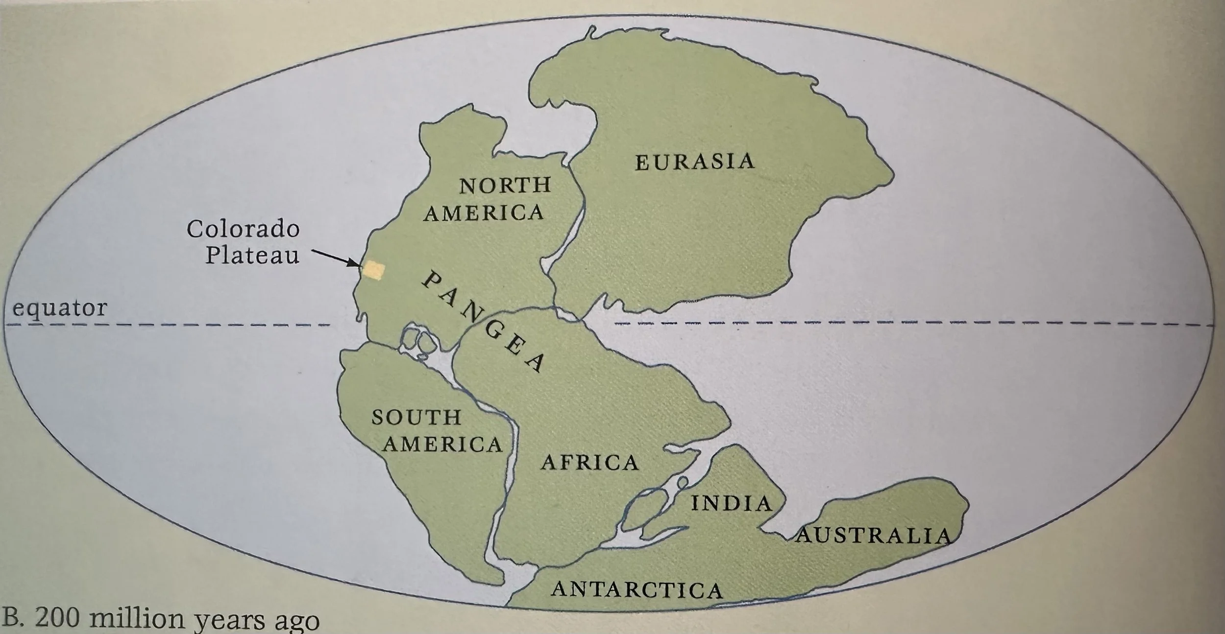
Pangaea: An ancient supercontinent that broke apart 200 Ma to form the present-day continents.
Quartzite: A type of metamorphic rock that forms when sandstone is heated to high temperatures, fusing the individual sand grains together.
Reverse Fault: A fault caused by compression in which the block above the fault plane has moved up relative to the other block.
Rifting: The process whereby Earth’s crust is stretched and thinned; usually where two plates or sections of plates are pulling apart.
Rio Grande Rift: A network of deep, down-faulted valleys or grabens that extend along the Rio Grande, from Central CO south through NM into TX.
Stream Piracy: When a river cuts a channel through soft rocks until it ultimately erodes headward into the course of another river nearby, thereby capturing its flow.
Strike-Slip Fault: A fault where rocks slide horizontally past one another (San Andreas Fault).
Syncline: A trough-like downward sag or fold in rock layers.
Thrust Fault: A special kind of reverse fault where older rock layers are pushed up and over younger rock layers; movement takes place along a low angle (<45 degrees) or almost horizontal surface.
Unconformity: A break or gap in the geologic record where rock layers were eroded or never deposited, resulting in younger layers lying directly atop much older rocks; described as an angular unconformity when the rock layers of different ages meet at an angle.
___________________________________________________________________________
Chronology
1064: Lava erupts along a 10km long fissure creating a curtain of fire on the Southern CO plateau and forming the cinder cone volcano, Sunset Crater (Hiking the Southwest by Hopkins).
900-1150: Chaco canyon is inhabited by Ancestral Puebloan (Hiking the Southwest by Hopkins).
60 Ka: Ice age glaciers are at their max extent (Hiking the Southwest by Hopkins).
100 Ka: Ice age glaciers are at their max extent (Hiking the Southwest by Hopkins).
150 Ka: Ice age glaciers are at their max extent (Hiking the Southwest by Hopkins).
150 Ka: Lava flows from a single cinder cone, Merriam Crater, diverts the course of the Little CO River, creating Grand Falls (Hiking the Southwest by Hopkins).
200 Ka: Formation of the volcano O’Leary Peak, when viscous, silicate-rich rhyolite lava constructs a steep-sided lava dome on the modern CO plateau (Hiking the Southwest by Hopkins).
430 Ka: Volcanic eruption of San Francisco Mountain on the modern CO plateau (Hiking the Southwest by Hopkins).
~1 Ma: The Grand Canyon is cut to its present depth (Hiking the Southwest by Hopkins).
~6 Ma: The CO River begins carving the Grand Canyon (Hiking the Southwest by Hopkins).
10 Ma: Uplift of the Rocky Mountains accelerates (Hiking the Southwest by Hopkins).
10 Ma: Eruption of basalt-dominated volcanoes in the San Francisco Mountains and Springerville Volcanic Fields along the plateau’s Southern margin in Arizona and in the Datil-Mogollon Volcanic field in NM (Hiking the Southwest by Hopkins).
15 Ma: Faulting begins to break apart the western edge of the CO Plateau (Hiking the Southwest by Hopkins).
30 Ma: Renewed uplift occurs on the CO Plateau (Hiking the Southwest by Hopkins).
30-19 Ma: Volcanic eruptions in the Tushar mountains erupt from a cluster of at least five tall composite or stratovolcanoes, spewing tremendous volumes of predominantly rhyolite and andesite tuff and breccia (Hiking the Southwest by Hopkins).
31-20 Ma: Laccolith’s squeeze between the CO Plateau’s sedimentary layers creating the La Sal, Abajo, and Henry Mountains, all now exposed following extensive erosion (Hiking the Southwest by Hopkins).
55 Ma: Formation of the white and pink colored Claron limestone on the modern CO Plateau when the region lay within a large, shallow freshwater lake that covered much of south-central UT. As the level of the lake fluctuated, sluggish meandering streams flowed across mudflats and deltas around the lake basin, depositing a tremendous amount of mud and silt. Local conglomerate layers represent gravel deposited in stream channels (Hiking the Southwest by Hopkins).
65 Ma: The Laramide Orogeny uplifts the Rocky Mountains and pushes the Arizona Precambrian basement layers skyward, creating a highland to the South in Central Arizona called the Mogollon highlands (Hiking the Southwest by Hopkins).
65 Ma: The pace of Atlantic sea-floor spreading possibly quickens, accelerating the rate of subduction of the Pacific Sea floor beneath North America. This may have flattened the angle of subduction, causing the Pacific Plate to impinge on the region's basement rocks. The basement squeezed like an accordion, sending some rocks skyward to become mountains (as in Colorado) (Hiking the Southwest by Hopkins).
100 Ma: Formation of the Cretaceous Ferron sandstone on the modern CO Plateau, when the area lay along a sandy shoreline that bordered the Cretaceous seaway (Hiking the Southwest by Hopkins).
100-70 Ma: The Cretaceous seaway repeatedly submerges the CO plateau region (Hiking the Southwest by Hopkins).
150 Ma: Formation of the Navajo sandstone on the modern CO plateau, when the region was part of a vast Sahara-like desert along the W. coast of N. America. As the dunes were buried under more and more sand, they became saturated with groundwater, which slowly cemented the sand grains together, turning the dunes to stone (Hiking the Southwest by Hopkins).
160 Ma: Formation of the Entrada sandstone on the modern CO Plateau when Sahara like local wind-blown sand dunes blew on a flat coastal plain or tidal flat (Hiking the Southwest by Hopkins).
175 Ma: Formation of the Navajo Sandstone on the modern CO plateau, when stacks of large scale, wind-blown dunes blanketed the entire region (Hiking the Southwest by Hopkins).
200 Ma: Formation of the Wingate sandstone on the modern CO Plateau, when thick piles of wind-blown sand that accumulated during the Jurassic. The Wingate lies below the steam-deposited Kayenta formation (Hiking the Southwest by Hopkins).
200-175 Ma: Formation of the Navajo, Entrada, and Wingate sandstones on the modern CO plateau when the region was part of the Jurassic “sand pile” of wind-blown dunes (Hiking the Southwest by Hopkins).
225 Ma: The pine-like conifer trees of the extinct genus Araucarioxylon that comprise modern Petrified Forest National Monument fall (Hiking the Southwest by Hopkins).
225 Ma: Formation of the brick red Chinle layer on the modern CO plateau comprised of mudstone, siltstone, sandstone, and conglomerates and deposited by Triassic streams (Hiking the Southwest by Hopkins).
250 Ma: Formation of the Kaibab limestone on the modern CO Plateau, when the area was submerged under a warm, shallow sea. The Kaibab comprises the present-day rim of the Grand Canyon (Hiking the Southwest by Hopkins).
260 Ma: Formation of the De Chelly sandstone on the modern CO plateau, when the area was comprised of giant wind-blown dunes (Hiking the Southwest by Hopkins, NPS).
300 Ma: Orogeny of the ancestral Rocky Mountains, which causes uplift and erosion along the Uncompahgre and Defiance plateaus (Hiking the Southwest by Hopkins).
450 Ma: Coral Reefs begin growing in the world’s oceans (Hiking the Southwest by Hopkins).
4.3 Ga: Earth experiences 10M years of intense rainfalls that cool the Earth and wash minerals from the hot rocks into the oceans. As a result, the oceans that form are a complex solution of salts (Hiking the Southwest by Hopkins).
___________________________________________________________________________
