Geological History and Geodiversity of the Amazon by Val
Ref: Val et al (2022). Geological History and Geodiversity of the Amazon. Science Panel for the Amazon
https://www.researchgate.net/publication/359705180_Geological_History_and_Geodiversity_of_the_Amazon
___________________________________________________________________________
Summary
Amazonian history unfolded over the course of 3 Gy. During this time, the geological substrate of the Amazon region formed part of different continents, with the current configuration only taking shape in the past 100 My. Key geographic features such as the Andes mountains at the western margin of the Amazon, and the connection between South and Central America were only completed in the past 20 My. Conversely, the building blocks of the eastern Amazon were configured between 3-1 Ga. The timing of these configurations (west and east) and their legacy effects, such as the stability of the eastern Amazon and mountain building in the western Amazon, were largely dictated by the movement of tectonic plates. The interconnection between these ‘old’ and ‘young’ crustal regions is what makes the Amazon unique. For example, the east-west gradient of geological province ages is reflected in soil types, which in turn creates gradients in soil nutrients and, therefore, ecosystems. The overall distribution of rain in the Amazon is directly shaped by the Andes which, along with soil types, interconnect to affect hydrological conditions in the lowlands. Climate, soils, hydrology, mineral and hydrocarbon wealth, and biodiversity are either derived from or superimposed on this diverse geological tapestry crafted by geological time.

___________________________________________________________________________
Geologic History
As South America drifted westward during the opening of the Atlantic Ocean, the western margin of the South American plate experienced tectonic plate convergence, the driving force of mountain building. However, South America had no significant mountains along its west coast during most of the last 100 Ma. Despite the long history of westward drift and tectonic convergence on its western edge, it wasn't until the last 40 ± 10 Ma that the significant topographic expressions of the Andes began forming. This delayed mountain building is puzzling and remains a matter of debate.
The Andes rose as high as 4 km in southern Peru by 10–15 Ma. As uplift continued, the Andes also became wider, and by 7 Ma it reached 4–5 km elevation about 450 km away from Pacific Coast in southern Peru and northern Bolivia. The southern Peruvian Andes became wider, while northern Peru, Ecuador, and Colombia had much less expressive topography. Evidence diverges on paleo-elevations during the Miocene, but it seems that it was not until 4–5 Ma that a 3 km high Andes flanked the Amazon's NW. Importantly, when the Andes north of the Altiplano reached 2.5 km or more, atmospheric circulation was incrementally blocked, driving high orographic rainfall in the Andean foothills and fundamentally changing the climatic regime over South America. The Andean foothills got wetter, and parts of the eastern Amazon became drier.
Large sedimentary loads were exported from the uplifting and eroding Andes into the alluvial mega-fans, hinterland, and foreland basins. These processes also created the necessary conditions (i.e., thick and porous medium) to form the major groundwater aquifers.
Evidence from paleorecords that cover the last two glacial-interglacial cycles (c. 250,000 years) reveals distinct climate profiles in the eastern and western Amazon, the so-called South American precipitation dipole. This dipole consists of a differential precipitation pattern over the Amazon, where wet-dry conditions varied substantially in the eastern Amazon, while precipitation variability was much less in the western Amazon, including the Andes
Where rivers flow over and out of cratonic areas (i.e., shields), spatial changes in relief are drastic and likely long-lasting. Extending over all the northern and southern edges of the Amazon's drainage basin, there are outcrops of cratonic rocks, which form wide plateaus mostly with 500-1,000 m elevation but reaching upwards to 2,500 m in the northernmost reaches of the Amazon in southern Venezuela and at the border between Brazil and Guyana. Here, the so-called Tepui form astounding table-top mountains which are supported by highly-resistant metamorphic rocks of the Amazon Craton and stand tall above the Amazon lowland.
The geological contrasts described above are 1) deeply entrenched rivers in the uplifting Andes with a mix of equilibrium and non-equilibrium landscapes; 2) low-relief, near-equilibrium landscapes in the western Amazon lowlands over relatively soft sedimentary rocks with text- book examples of dendritic and meandering fluvial patterns; 3) complex topographic forms in the shields with low-relief plateaus surrounded by intensified river excavations and anomalous river network configurations due to lithological contrasts.


___________________________________________________________________________
Geodiversity & Soils
Soils facilitate (i) the storage, supply, and purification of water; (ii) plant growth; (iii) atmospheric modifications; and (iv) habitats for organisms and microorganisms. Moreover, soils provide essential resources for primary production (photosynthesis) through the availability of essential mineral elements and water that support terrestrial and aquatic food webs.
Soil formation and evolution occur through the interactions of five major factors: 1) parent material (e.g., rock type and minerals), 2) geomorphology (local landscape relief), 3) climate (hydrological and evaporative regimes governing water fluxes through sediments), 4) interactions with organisms (e.g., soil and root-associated microfauna and meiofauna), and 5) time.
Chemical weathering processes include carbonation, dissolution, hydrolysis, oxidation- reduction.
Physical weathering occurs through geomorphic processes that break soil particles into smaller sizes, whereas most chemical weathering of Amazonian soils involves reactions with water.
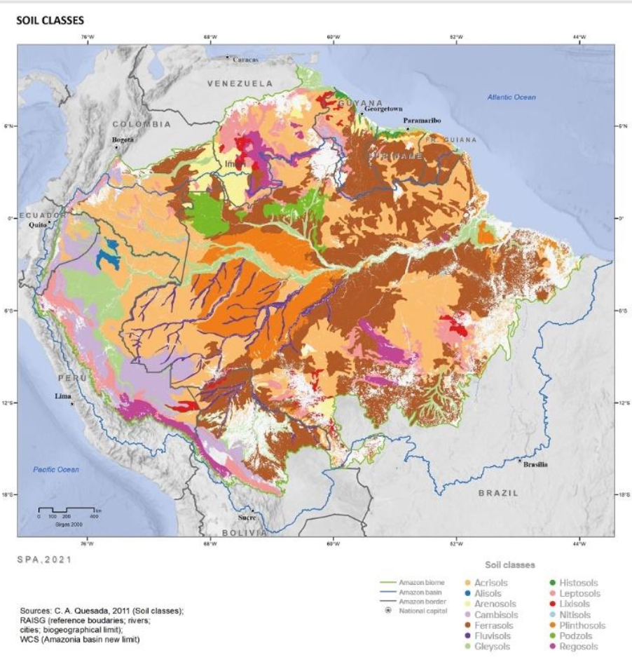
~60% of soils in the Amazon drainage basin are highly-weathered, nutrient-poor ferralsols and acrisols, concentrated mainly in the eastern Amazon.
Because the P pool is gradually transformed to unavailable forms, P is the main nutrient limiting ecosystem productivity in ancient Amazonian soils. On the other hand, N is mainly supplied to soils through atmospheric N deposition and microbial N2 fixation, thus accumulating throughout soil development. N is not limiting in mature forests, but N limitation does occur in disturbed forests (e.g., logging, fires, large scale mortality events) and white sand forests.
Younger soil types that have not suffered extensive weathering almost invariably show a lower degree of vertical development, often being shallow and with hard subsurface horizon that restrict root growth. Soil types that have resulted from many millions of years of weathering usually have favorable physical properties, such as well-developed soil structure, good drainage, and, due to their depth, high water storage capacity. This trade-off between physical quality and nutrient availability contributes strongly to the diversity of environments in the Amazon and causes deep effects on how the ecosystem functions.
___________________________________________________________________________
Hydrology
River Capture (‘stream piracy’): The process by which the tributaries of one river basin capture a fraction of a neighboring river network; often arises from an imbalance in erosion rates between streams sharing a drainage divide.
River Avulsions: Changes in the position of active river channels that arise from hydrological and geomorphological processes. Avulsions are usually autogenic in nature and span timescales of years to thousands of years. As rivers avulse into another channel, they leave fluvial “scars” behind, also called fluvial escarpments, as well as alluvial fans, which are kilometer- wide fan-shaped sedimentary deposits.
The chemical composition of the waters in the Amazon largely reflects the geologic substrates through which the water flows. The geochemistry of soil water, particularly soil nutrients for vegetation, which strongly depend on the bedrock (parent material) and geologic age.
Amazon River Types
Blackwater Rivers: Originate in lowland forests with sandy soils that are nutrient poor and highly acidic (pH = 3.5– 6.0).
Whitewater Rivers: Sourced in the geologically-young Andean cordilleras, which are sediment- and nutrient-rich and have near neutral pH (6.8–7.0).
Clearwater Rivers: Drain the old cratonic shields, which are sediment- and nutrient-poor and slightly acidic (pH = 6.1–6.7).
Some of the main hydrologic landscapes of the Amazon are periodically flooded wetlands such as igapó (blackwater and clearwater) and várzea (whitewater), which contrast with the terra firme that is never flooded.
Amazon Aquifer System (AAS): The Alter do Chão Formation is exposed in the eastern Amazon and continues westward from the Amazonas to Solimões sedimentary basins, where it has been assigned two aquifer names: Alter do Chão (Amazonas sedimentary basin) to the east where it is exposed, and Tikuna (Solimões sedimentary basin) to the west, where it is buried. Three aquifers are stacked vertically: the Iça, Solimões, and Tikuna (or Alter do Chão).
In terms of precipitation, the Amazonian hydrological cycle is closely tied to the seasonal movements of the intertropical convergence zone (ITCZ) over the Atlantic, which shapes the South American monsoon. Additional precipitation forcing is caused by substantial rainforest transpiration playing a role in the onset of the monsoon and contributing large amounts of water vapor and precipitation to the Amazon drainage basin. The dry-to-wet transition season is additionally influenced by the significant amount of evapotranspiration from the Amazonian Forest canopy landscape.

___________________________________________________________________________
Minerals
Ore Deposits: Anomalous concentrations of an element of economic interest within the Earth’s crust. Ore deposits may form as a result of (i) interaction of the lithosphere, hydrosphere, atmosphere, and biosphere; (ii) decrease in internal global heat production, and (iii) changes in global tectonics.
Amazon Ore Deposits
Carajás: Fe, Cu, Au, Mn, and Ni.
Pitinga: Sn, Nb, and rare earth elements (REE).
Serra do Navio: Mn.
Trombetas-Juruti: Al
Al deposits (bauxite ores) are quite common in the Amazon and encompass large reserves.
The first oil reserves were not discovered until the 1980s in the Llanos region of Venezuela. Subsequently, hydrocarbon exploration expanded south from Colombia into Ecuador and Peru. The greatest proven hydrocarbon reserves are now known to occur in the westernmost Amazon, at the foothills of the Andes.
In 1978 the Juruá gas field was discovered by Petrobras (the state-owned Brazilian oil company). Petrobras started a new exploratory campaign which eventually led to the discovery of the oil and gas field of Rio Urucu in 1986, deep in the hinterland of the western Amazon and in the Solimões sedimentary basin. Initially, only the oil of the Urucu Province was exploited. At the very beginning it used barges, but in 1997 an oil pipeline was installed to transfer the oil to a harbor at the town of Coari. From there, oil tankers transport it to Manaus. During the 2000s, a gas pipeline connecting Urucu to Manaus was built and started operating in 2006.

___________________________________________________________________________
Outlook
Major problems in the Amazon include 1) deforestation due to dam and road construction, 2) mineral extraction, and associated land-use changes, 3) global climate change and 4) sea level rise.
Anthropogenic global warming is already having dramatic environmental consequences for Amazon, with the greatest future impacts resulting from sea level rise and pronounced shifts in rainfall patterns and intensities.
Melting polar ice caps will contribute to more than 13 m global sea level rise by 2500, and complete loss of the Earth’s ice caps is projected within the next 400-700 years. In an ice-free world, global sea levels will be c. 60-80 m above the present level, higher than they have been for c. 56 My.
The Amazon is precipitously on the edge of an evolutionarily unique climatic regime shift, an irreversible change from mostly forested to mostly open and environmentally degraded agricultural, marginal, and abandoned landscapes.
Future Amazonian landscapes may look very different from the vast tropical rainforests that have covered most of the region for the past 100 My.

___________________________________________________________________________
Terminology
Pantepui: Amazonian sandstone table-top platforms such as Mount Roraima on the Guiana Shield.
___________________________________________________________________________
Chronology
2500: Global sea levels rise by >13m due to melting polar ice caps (DeConto, 2016).
10-4.5 Ma: Formation of the Amazon River; the rise of the Andes causes an eastward tilt that results in drainage changes and the formation of the transcontinental Amazon River (Val, 2022).
10 Ma: The Amazon’s Pebas mega-wetland system transitions into alluvial mega-fans (Val, 2022).
17-15 Ma: The Middle Miocene Climatic Optimum (MMCO); Earth’s global mean surface temperature is 18.6°C (pre-industrial era temperatures were c. 14°C ) (Inglis, 2020).
20 Ma: The Central and Northern Andes Mountains reach their present altitudes (Val, 2022).
23-10 Ma: Much of the Western Amazon is covered by an immense mega-wetland called the Pebas system. This shallow, lake-dominated wetland system extended over 1M sqkm (Val, 2022).
40 Ma: The Andes mountains begin forming reaching 4 km by 10-15 Ma and 4-5 km by 7 Ma (Val, 2022).
~45 Ma: Antarctica and Australia break away from South America (Val, 2022).
53-51 Ma: The Early Eocene Climatic Optimum (EECO); Earth’s global mean surface temperature is 27°C (pre-industrial era temperatures were c. 14°C ) (Inglis, 2020).
55 Ma: The Paleocene-Eocene Thermal Maximum (PETM); Earth’s global mean surface temperature is 31.6°C (pre-industrial era temperatures were c. 14°C ) (Inglis, 2020).
120-100 Ma: Africa and South America begin separating; leading to the opening of the Atlantic Ocean and, eventually, uplift of the Andes mountains (Val, 2022).
~540 Ma: An E-W rift develops along the Amazon craton, almost splitting it into Northern and Southern portions. However, that rifting process did not persist, but resulted in the formation of an intracontinental depression that subdivided the craton into cores of what would become the modern Guiana and Brazilian shields. This depression formed the basement of the Solimoes and Amazonas sedimentary basins and for the past 400 My, was mostly a depression forming a seaway between the peripheral oceans and interior seaways. Today this depression forms the pathway of the Amazon River with its tributaries in the surrounding uplands (Val, 2022).
640 Ma: The Gondwana mega-continent assembles (Val, 2022).
1 Ga: The Rodinia supercontinent breaks up (Val, 2022).
1.2-1 Ga: The Rodinia supercontinent assembles (Val, 2022).
1.9 Ga: The Columbia supercontinent fragments (Val, 2022).
2.1-1 Ga: Formation of the Amazon craton as crustal terranes amalgamate with the pre-Cambrian shield, occupying most of modern-day Western Brazil (Val, 2022).
3-2.5 Ga: Formation of the Amazon’s Pre-Cambrian shield in the area corresponding to the modern Carajás Province (Val, 2022).
___________________________________________________________________________